Gulf Research Program Awards over $7 Million to Advance Scientific Understanding of Sea-Level Variation and Rise in the Gulf Region
News Release
By Pete Nelson
Last update January 27, 2026
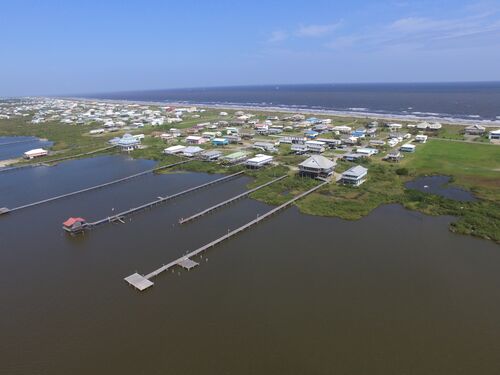
WASHINGTON — The Gulf Research Program (GRP) of the National Academies of Sciences, Engineering, and Medicine today announced an award of more than $7.3 million to support four interdisciplinary research projects aimed at advancing scientific understanding of sea-level variation and rise in the Gulf region to strengthen long-term planning, preparedness, and resilience.
The awarded projects will refine projections of future sea-level rise by integrating high-resolution modeling, machine learning approaches, end-user engagement, and analysis of key physical and human drivers of coastal change. By advancing understanding of the physical processes that cause relative sea-level change and translating that knowledge into usable tools and products, these projects will improve the accuracy, actionability, and regional relevance of sea-level projections. Collectively, they will provide communities, agencies, and decision-makers with more robust and locally relevant information to guide long-term adaptation and hazard preparedness.
“Reliable, actionable, and regionally focused sea-level information is a cornerstone of resilience planning in the Gulf,” said Michael Feldman, program director of GRP’s Gulf Environmental Protection and Stewardship Unit. “The research supported through these awards will provide planners, agencies, and communities with the science they need to make forward-looking decisions.”
The awarded projects are:
Project Title: Shifting Land, Rising Seas: Forecasting How Human and Climate Drivers Shape Gulf Coast Sea-Level Futures
Project Director: Andrew Hoffman, Rice University
Award: $1,955,645
Description: This proposal addresses major uncertainties in Gulf Coast sea-level rise (SLR) projections by integrating vertical land motion (VLM), hydroclimate variability, and community vulnerability into a unified forecasting framework. Current projections often underrepresent the combined effects of subsidence, sediment loading, groundwater and hydrocarbon extraction, and atmospheric variability, all of which shape relative sea-level change. To address these gaps, the team will merge geodetic observations with poromechanical models of compaction and glacial isostatic adjustment, along with climate-model large ensembles that capture short-term variability such as El Niño-Southern Oscillation and decadal atmospheric patterns. These physical projections will be combined with a dynamic vulnerability index using data on infrastructure abandonment, population migration, and housing trends to assess how communities may respond to SLR and flooding stressors. Expected outputs include high-resolution subsidence datasets, improved probabilistic SLR projections that integrate geophysical and human drivers, incorporation of results into the Framework for Assessing Changes to Sea-Level (FACTS) platform, and interactive visualization and mapping tools to support adaptation planning.
Project Title: Predicting Submonthly Gulf Coast Sea-Level Variability and its Effect on Flooding
Project Director: Christopher Little, JANUS Research Group LLC
Award: $1,590,452
Description: This project will take a four-part approach: (1) quantify relationships between coastal sea-level anomalies and flood metrics such as inundation duration, extent, and severity, using NOAA’s high-resolution Coastal Ocean Reanalysis tool; (2) diagnose the origins of submonthly variability, distinguishing local versus remote drivers, and evaluate how well global climate models represent these dynamics; (3) develop a hybrid statistical–dynamical forecasting system that combines climate model output, bias corrections, and reanalysis data to improve predictions of flooding; and (4) integrate these tools into NOAA’s High Tide Flooding Outlooks to enhance operational products. This effort leverages Community Earth System Model high-resolution simulations, tide gauges, satellite altimetry, and fast inundation models to validate and extend results. Anticipated outputs include new probabilistic tools for predicting localized flood impacts, improved understanding of model biases, and prototype products directly usable by NOAA, local planners, and emergency managers.
Project Title: Gulf Sea-Level Rise: Harnessing glObal and Regional High-Resolution Models to Enhance Projections (SHORE)
Project Director: Ping Chang, Texas A&M University
Award: $2,898,540
Description: This project is a two-phase effort to generate advanced projections of Gulf Coast sea-level rise (SLR) using global and regional high-resolution climate and ocean models. In Phase I, the team will expand ensembles of the Community Earth System Model at high resolution (CESM-HR, ~10 km) across a full range of emission scenarios and dynamically downscale them with ultra-high-resolution coastal models that resolve tides, waves, river discharge, and estuarine processes. These simulations will provide sub-100 m flood and inundation maps validated with satellite data from the Surface Water and Ocean Topography mission and in situ buoy observations. In Phase II, the project will transition to CESM3 with an ocean model that simulates barystatic SLR from land ice melt and freshwater fluxes. Diagnostics will assess how large-scale climate modes influence regional SLR. The project will deliver daily-to-decadal projections, probabilistic risk estimates, and visualization tools co-developed with end users.
Project Title: High-Resolution, Scenario-Based Sea-Level Projections: Integrating Vertical Land Motion, Ocean Dynamics, and Atmospheric Forcing
Project Director: Laurent Cherubin, Florida Atlantic University
Award: $900,000
Description: This project will focus specifically on data integration through machine learning forecasting and community decision support. The team will develop a graph-based probabilistic machine learning framework that integrates multivariate predictors such as ocean heat content, atmospheric indices, and vertical land motion to forecast long-term sea-level rise and extreme water-level events. This approach is designed to capture local dependencies and large-scale teleconnections, producing ensemble-based predictions that complement deterministic models. The team will also collaborate with Florida Sea Grant and coastal communities to co-develop an interactive decision-support platform. This tool will provide scenario-specific outputs for 2030, 2050, and 2100, alongside workshops, training, and outreach materials to strengthen local capacity for adaptation and preparedness.
The National Academies’ Gulf Research Program is an independent, science-based program founded in 2013 as part of legal settlements with the companies involved in the 2010 Deepwater Horizon disaster. The GRP’s mission is to develop, translate, and apply science to enhance the safety of offshore energy, the environment, and the well-being of the people of the Gulf region for generations to come. It supports innovative science, guides data design and monitoring, and builds and sustains networks to generate long-term benefits for the Gulf region and the nation.
The National Academies of Sciences, Engineering, and Medicine are private, nonprofit institutions that provide independent, objective analysis and advice to the nation to solve complex problems and inform public policy decisions related to science, engineering, and medicine. The National Academies operate under an 1863 congressional charter to the National Academy of Sciences, signed by President Lincoln.
Contact:
Pete Nelson, Director of Public Engagement and Communications
Gulf Research Program
email PNelson@nas.edu