Tools and Technology for Roadside Vegetation Asset Management: A Guide (2025)
Chapter: Appendix B: Case Studies

APPENDIX B
Case Studies
California Department of Transportation
About Caltrans
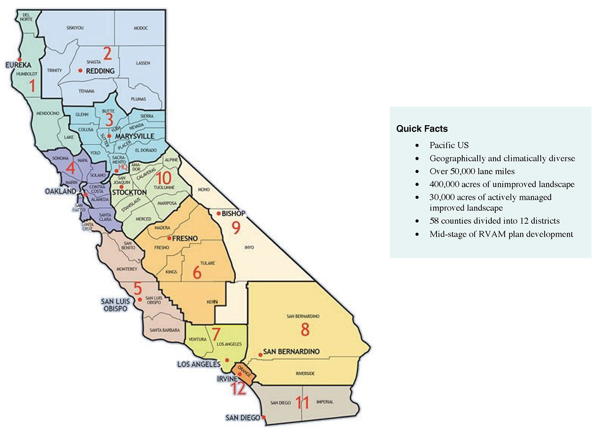
The California Department of Transportation (Caltrans) operates in a hybrid structure with centralized headquarters and 12 individual districts across the state (Figure B-1). The central headquarters establishes statewide goals and performance targets, issues funding, and tracks the progress of districts. Districts identify roadside rehabilitation and vegetation management project locations and detailed scopes of work.
Caltrans operates on a zero-based budget, so funding is not guaranteed for any operation. Caltrans uses both state and federal funds for Roadside Rehabilitation and Vegetation Management (Senate Bill 1 2017, Senate Bill 486 2014, Moving Ahead for Progress in the 21st Century Act [MAP 21] 2012).
Caltrans has the largest number of landscape architects (250 to 300) of any transportation agency in the United States. Caltrans makes use of the Division of Research, Innovation, and System Information (DRISI), a research division within the department. DRISI develops comprehensive solutions and distributes knowledge within Caltrans to help develop tools and technology. DRISI plays a major role in fire-suppression strategies, landslide prevention, and managing other major environmental concerns within California.
Roadside Asset Management Plans
Caltrans is dedicated to improving operations and ensuring goal-based attainable, environmentally conscious, and data-driven efforts to manage roadside vegetation assets. The Roadside Preservation Program (RPP) and the Integrated Vegetation Management Plan (IVP) are Caltransʼs Roadside Vegetation Asset Management (RVAM) plan and capture these goals and the management framework.
Caltrans manages roadside landscape assets under two divisions—Design and Maintenance. The Division of Design manages the long-term RPP performance of assets through geographic information system (GIS)-based maps and dashboards. The Division of Maintenance identifies and addresses the short-term needs of the roadside vegetation through its IVP. While the Division of Designʼs GIS mapping has been incorporated into the state Transportation Asset Management Plan (TAMP) (which includes bridges, pavement, and culverts), the IVP has not been incorporated into the TAMP.
Caltrans is moving toward multi-asset project development, wherein multiple programs simultaneously contribute staff and expertise to a single effort (i.e., road paving is completed directly following pipe replacement, and then permanent vegetation is completed under the same
Long Description.
The twelve districts marked in the map from 1 to 12, respectively, are as follows: Eureka, Redding, Marysville, Oakland, San Luis Obispo, Fresno, Los Angeles, San Bernardino, Bishop, Stockton, San Diego, and Irvine. Quick facts are in a box on the right. They are Pacific US; geographically and climatically diverse; over 5,000 lane miles; 400,000 acres of unimproved landscape; 30,000 acres of actively managed improved landscape; 58 counties divided into 12 districts; and mid-stage of RVAM plan development.
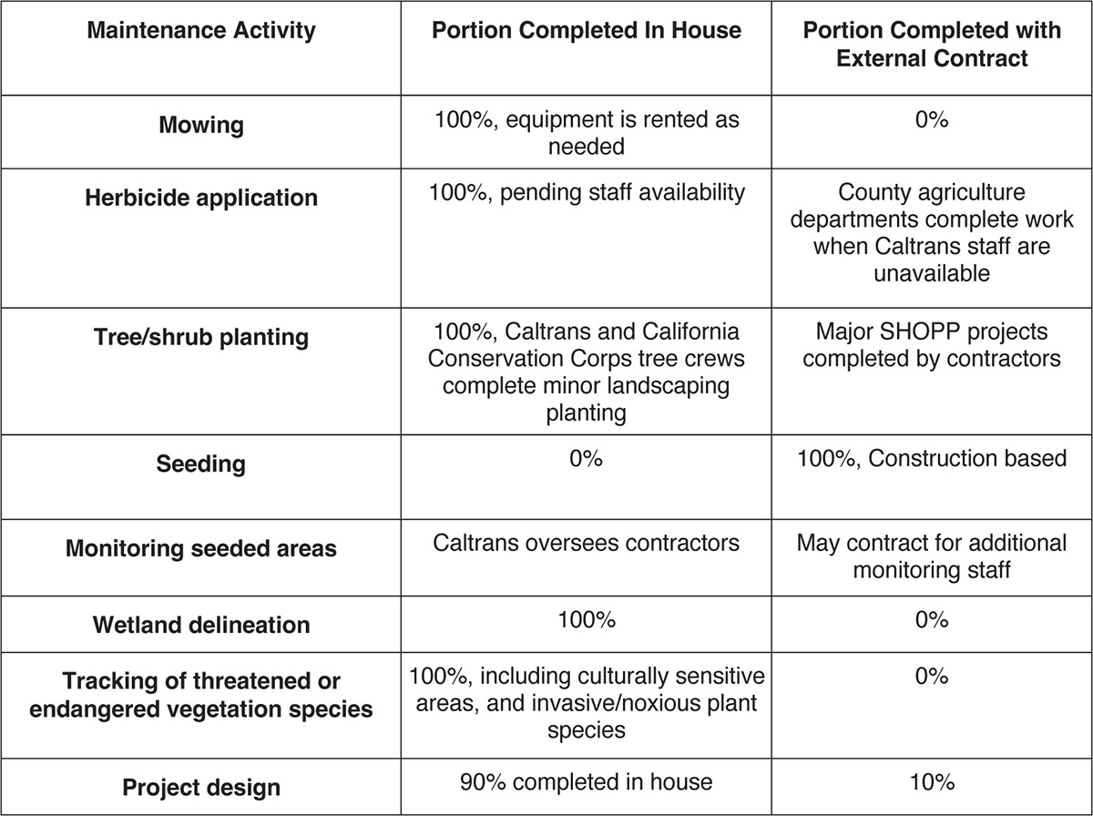
project). This decreases costs and minimizes the number of separate projects affecting the public. The multi-asset approach allows for large-scale projects to be completed with all necessary updates to each component (e.g., sewer, electrical, pavement, bridge, and landscape) under one contract. Most Caltrans roadside vegetation asset management work is completed in house (Table B-1), but Caltrans contracts work externally when staffing or equipment issues arise.
Roadside Vegetation Asset Management
The Division of Maintenanceʼs IVPs are updated annually; the system for IVP development was established in 1992. These plans provide guidelines for vegetation management, including mowing and brush removal. The most recent update to the IVPs includes changes to the operating framework. The Division of Designʼs current system for IVP development is based on the federal 2012 MAP-21, which established asset classes, performance measures, and targets that helped Caltrans shift toward more objective, goal-based asset management. Additionally, the passage of California Senate Bill 1 required Caltrans to document $200 million worth of efficiencies annually. This drove Caltrans to develop performance metrics and a rating system for assets to determine asset conditions accurately and customize specific management actions to improve the site conditions.
Long Description.
The column headers of the table are Maintenance Activity, Portion Completed In-House, and Portion Completed with External Contract. The data given in the table row-wise are as follows: Row 1: Mowing: 100 percent; equipment is rented as needed; 0 percent. Row 2: Herbicide application: 100 percent, pending staff availability; County agriculture departments complete work when Caltrans staff are unavailable. Row 3: Tree or shrub planting: 100 percent, Caltrans and California Conservation Corps tree crews complete minor landscaping planting; Major SHOPP projects completed by contractors. Row 4: Seeding: 0 percent; Construction-based, 100 percent. Row 5: Monitoring seeded areas: Caltrans oversees contractors; May contract for additional monitoring staff. Row 6: Wetland delineation: 100 percent; 0 percent. Row 7: Tracking of threatened or endangered vegetation species: 100 percent, including culturally sensitive areas, and invasive or noxious plant species; 0 percent. Row 8: Project design: 90 percent completed in-house; 10 percent.
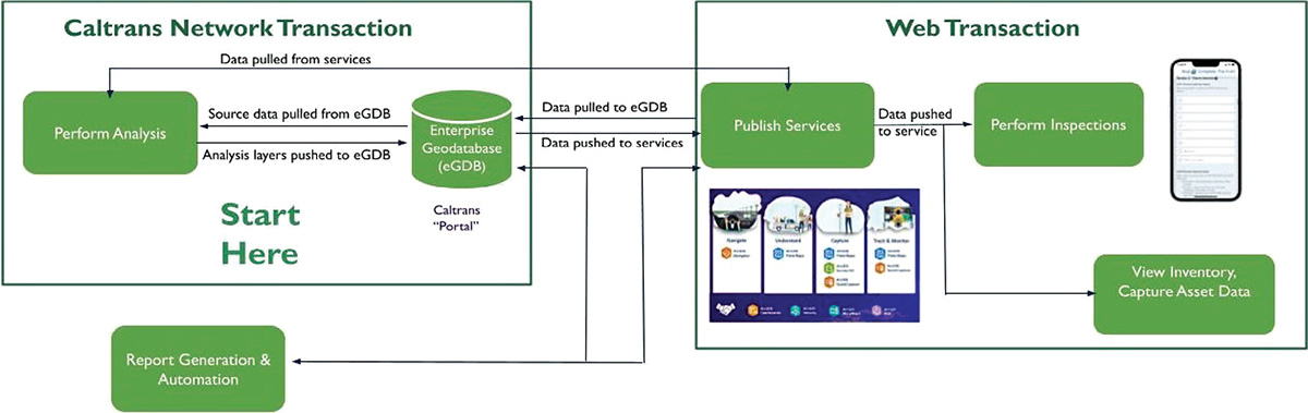
Districts edit GIS maps annually to update roadside landscape condition inventory data for the State Highway System Management Plan (SHSMP) and to update the IVP for each district. The SHSMP examines state and local transportation goals, identifies elements that apply to the state highway system, and assists in developing an executable 10-year plan. The 2023 SHSMP builds on the performance-driven framework from prior plans and further strengthens the integration of the IVP with the state TAMP, the Caltrans strategic plan, and the Climate Action Plan for Transportation Infrastructure (CAPTI). As part of the integration, Caltrans operates, maintains, upgrades, and expands physical assets throughout the asset life cycle. The current SHSMP aims to improve asset conditions from “poor” to “good” within the RPP. Areas within the RPP are actively managed and improved landscape areas in urban and suburban areas along access-controlled freeways and comprise approximately 32,000 acres. Districts are tasked with identifying 20% of the districtsʼ RPP inventory to be included in these updates by March of 2024, using GIS data collection and mapping applications on a state-provided cell phone or desktop. Every year, the districts will need to locate an additional 20% of their districtʼs RPP inventory that requires work. This will ensure that every 5 years, landscape architects will survey the entirety of the actively managed improved landscape areas and determine repairs as needed to prioritize funding for improvements that will enable condition statuses to be updated to “good.” All this information is updated in the statewide mapping system (Figure B-2).
The SHSMP is used to identify federally funded State Highway Operations and Protection Program (SHOPP) rehabilitation projects. These funds help support the maintenance of aesthetically planted areas. Funding for roadside rehabilitation performance in SHOPP projects received $28.9 million from the Roadside Rehabilitation legislation in 2023 per the SHSMP.
SHOPP major rehabilitation work is constructed through private-sector contractors; because of union contracts, Caltrans Maintenance staff perform most minor vegetation maintenance
Long Description.
The flowchart consists of two major sections, Caltrans Network Transaction and Web Transaction. Caltrans Network Transaction: Data is pulled from services and undergoes an analysis process. When performing analysis, the analysis layers are pushed to the Enterprise Geodatabase (eGDB). Source data is pulled from the eGDB or Caltrans "Portal" and leads to the analysis process. Web Transaction: From the eGDB, the data is pushed to services and pulled from services. The data is then published. The published data is also pulled to eGDB. Upon this, the data pushed to the service undergoes an inspection. The inventory is viewed, and the asset data is captured. As a result of both transactions, the report is generated and automated.
work in house. When contractors are hired, it is often because the equipment is unavailable or Caltrans staff are insufficient. As Caltrans has expanded the amount of maintenance completed along its right-of-way, the organization has created additional field maintenance positions for vegetation management, enabling staff to have focused work activities.
Software and Hardware
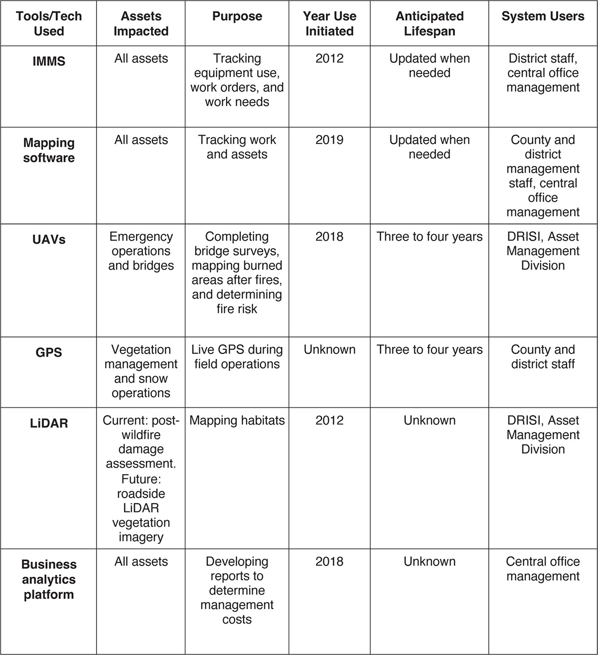
Caltrans is integrating technology into its operations to improve operational efficiency and accuracy in asset maintenance and management. To this end, Caltrans is adopting new systems, including the BIM for Infrastructure System and the IMMS. Caltrans is also expanding its use of current technology like unmanned aerial vehicles (UAVs), GPS, and LiDAR (Table B-2). Collaboration with other state entities and contracting subject matter experts facilitates these efforts.
IMMS: The Integrated Maintenance Management System (IMMS), designed in house for Caltrans, is used across the department. Staff enter vegetation control plans and work orders into the IMMS before beginning the work. The IMMS has an Annual Tree Inspection (ATI) dashboard and treatment data specific to irrigated landscapes (e.g., water management). The system also has a new risk assessment methodology process that analyzes product toxicity and a Pesticide Use Summary Report (PUSR) to track herbicide use. The IMMS tracks both costs and activities. County, route, and post mile information is standardized and will not change with road updates. Caltrans inputs this data into the IMMS. Data is exported from this system into an enterprise performance management system to generate reports and create dashboards.
Mapping software: Caltrans tracks landscape assets in asset management GIS software. Tracked assets include roadside aesthetic landscaped area condition, irrigation system condition, vegetation management acres (e.g., mowing, herbicide, and planting), and high fire-risk areas within the state roadway to prioritize landscape rehabilitation work (Figures B-3 and B-4). Data from the IMMS is imported into the mapping software for analysis and to ensure staff statewide have access to the information. Contracted subject matter experts are redesigning the state transportation asset management system (TAMS) to provide additional data fields, including field inspection data, district input, mobile device input, data quality validation, and detailed identification of specific needs by field staff.
Long Description.
The column headers of the table are Tools or Tech Utilized, Assets Impacted, Purpose, Year Use Initiated, Anticipated Lifespan, and System Users. The data given in the table row-wise are as follows: Row 1: IMMS: All assets; Tracking equipment usage, work orders, and work needs; 2012; Updated when needed; District staff, central office management. Row 2: Mapping software: All assets; Tracking work and assets; 2019; Updated when needed; County and district management staff, central office management. Row 3: UAVs: Emergency operations and bridges; Completing bridge surveys, mapping burned areas after fires, and determining fire risk; 2018; Three to four years; DRISI, Asset Management Division. Row 4: GPS: Vegetation management and snow operations; Live GPS during field operations; Unknown; Three to four years; County and district staff. Row 5: LiDAR: Currently: post-wildfire damage assessment. Future: roadside LiDAR vegetation imagery; Mapping habitats; 2012; Unknown; DRISI, Asset Management Division. Row 6: Reporting software: All assets; Developing reports to determine management costs; 2018; Unknown; Central office management.
UAVs: Caltrans uses UAVs in a limited capacity during emergency operations and for some structural maintenance activities (e.g., bridge inspections). DRISI is the main unit within Caltrans to use UAVs.
GPS: GPS devices are installed in all vehicles used for vegetation maintenance. The systems installed in the snow operations equipment can keep the vehicles within their lanes during operation. All GPS units are capable of live location tracking using 4G or 5G systems. This allows Caltrans to maximize equipment use by sending unused equipment to high-priority locations.
LiDAR: Caltrans uses LiDAR imagery to evaluate areas following wildfires and to identify blocked culverts, dead trees, and damaged roads. A 2019 climate change vulnerability analysis identified areas that are most vulnerable to fire impacts; this predictive analysis helps staff target assessments of pavement status and perform proactive maintenance, including dead vegetation removal. In 2023, Caltrans awarded a statewide contract to expand its use of LiDAR to assist in rating asset conditions, identifying needs, and directing field maintenance worker activities.
Long Description.
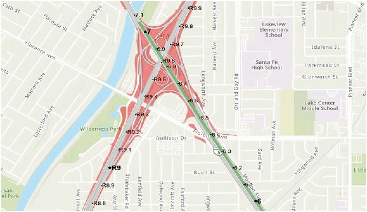
The map shows an intersection with a diagonal green line with gray lines on either side. The lines form a junction and are marked in numbers. The green line shows markings such as 7.1, 7, 6.9 to 6.1, and 6. The gray lines show markings of R 9.9 to R 9.1, R 9, R 8.9, and R 8.8. There are red polygons on either side of the of the gray and green lines. The regions covering this junction are Wilderness Park, Dollison Dr, Beuell Street, Longworth Avenue, Florence Avenue, Harvest Avenue, and Orr and Day Road.
Long Description.
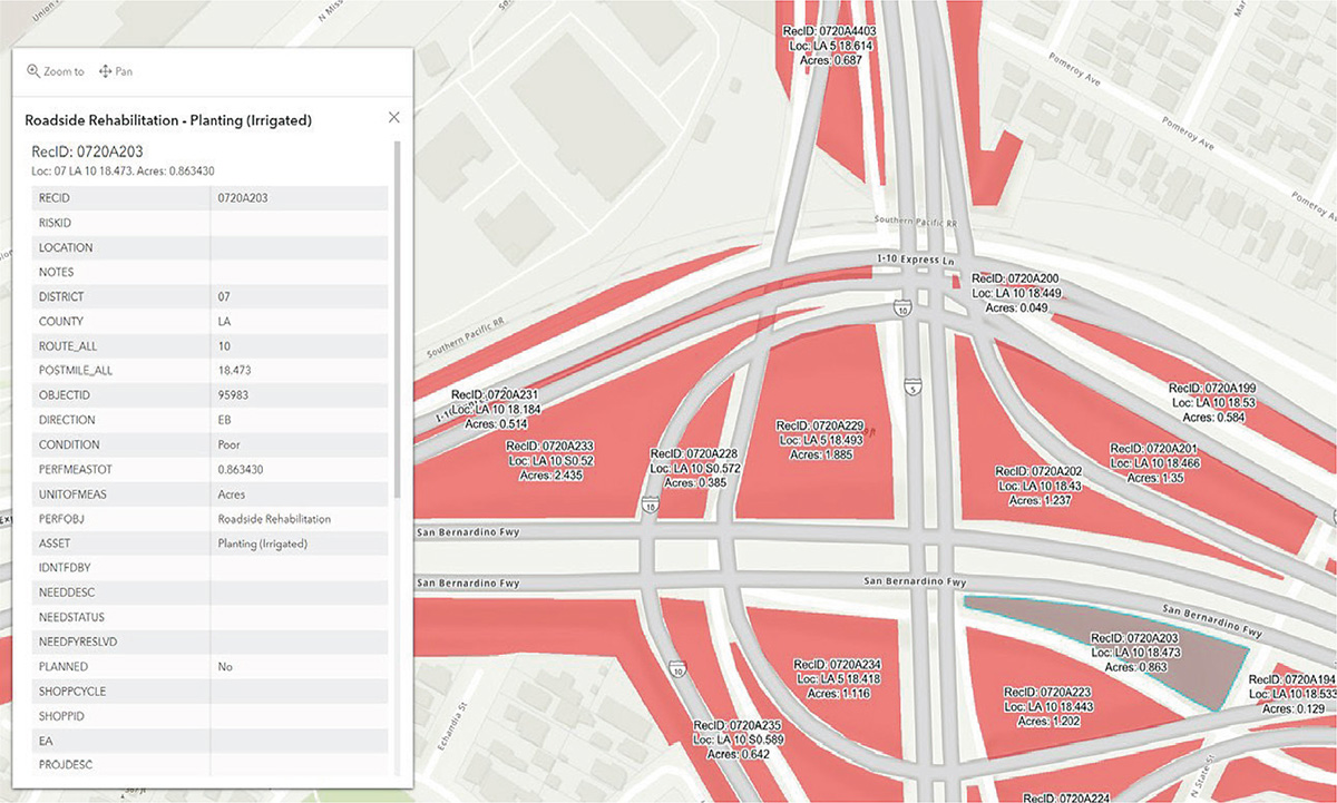
The map shows a close view of a junction along the San Bernardino Freeway. The junction shows several road intersections from all directions. A table within the map is titled 'Roadside Rehabilitation - Planting (irrigated).' The RecID is 0720A203, the location is 07 LA 10 18.473, and the covered areas are 0.863430. The table consists of two columns with data as follows: RECID: 0720A203; RISKID: Blank; LOCATION: Blank; NOTES: Blank; DISTRICT: 07; COUNTY: LA; ROUTE_ALL: 10; POSTMILE_ALL: 18.473; OBJECTID: 95983; DIRECTION: EB; CONDITION: Poor; PERFMEASTOT: 0.863430; UNITOFMEAS: Acres; PERFOBJ: Roadside Rehabilitation; ASSET: Planting (Irrigated); IDNTFDBY: Blank; NEEDDESC: Blank; NEEDSTATUS: Blank; NEEDFYRESLVD: Blank; PLANNED: No; SHOPCYCLE: Blank; SHOPPID: Blank; EA: Blank; PROJDESC: Blank.
DRISI plays a vital part in ensuring collected information can be used for planning. Caltrans has 14 licensed UAV pilots and 9 dedicated GIS team members, these 23 team members coordinate to operate nine UAVs (two with LiDAR sensors and seven with photogrammetry capability).
Business analytics platform: Caltrans business analytics platform is a commercially available tool that allows Caltrans management staff to determine the cost of management across the state accurately. This software enables cost information to be manipulated so that users can access data for specific areas of the state and for specific tasks.
Implementation
Caltrans is committed to improving operations and asset management to meet statewide goals and financial and sustainability targets. Planning and strategy, technology acquisition and expansion, and staff training are all critical components of implementing plans and systems that will help Caltrans effectively meet its mission. All maintenance staff are trained in the IMMS. All managers and a few field employees have access to technology that enables them to view the most up-to-date information available in the Caltrans system.
Problems with Implementation
It has been challenging to delegate roles and responsibilities while implementing the roadside vegetation asset management plan, identifying relevant departmental standards, and designing a plan that meets Caltransʼ needs within each district and program. As Caltrans adopted its asset management geodatabase, staff noted obstacles (e.g., identifying software applications, system architecture, which existing datasets to include, desired data fields, and workflow). Developing the geodatabase and keeping it current requires time and staff resources. Additionally, it takes time and effort to train field staff to collect and input accurate data into the GIS.
Staff have noted some inconsistencies with data quality, some of which can be partly attributed to errors in work order input (e.g., discrepancies in the number of acres treated). Because human error can lead to inaccuracies in determining asset condition data and the identification of specific needs, periodic spot reviews are completed to identify and correct data discrepancies.
Upcoming Implementation and Tasks
The Caltrans Division of Design plans to incorporate its roadside vegetation asset management program into TAMS, which is integrated with the state TAMP. To do this, Caltrans is working with its mapping software contractor to add features and fields to the geodatabase. The updates to TAMS will make it possible to update condition improvements automatically following construction. These TAMS updates will be operational in 2025.
Caltrans uses GIS as a planning tool for asset management. The agency will begin using Building Information Modeling for Infrastructure Initiative Implementation Plan (BIM4I) for project designs. The system will detail all structural and landscape information both above- and below-ground and can inform layered digital maps of structural and vegetation assets. BIM4I can be used in conjunction with LiDAR for effective mapping, moving Caltrans closer to the goal of creating digital twins, that is, digital models identical to their real-life object counterparts. This will ensure that multi-asset development can be completed with fewer issues.
Caltrans is investigating ways to enable district maintenance and design office staff to capture conditions and identify needs in the field with mobile devices. To this end, Caltrans Division of Design is working with the Asset Management Division to create the roadside vegetation asset
management plan. Development is expected to be completed within 2 years. In developing this program, the Office of Landscape Architecture Support and Planning is drawing inspiration and guidance from the Asset Management Division, specifically the culverts program, which recently implemented an asset tracking geodatabase developed over a 4- to-5-year planning period. The culverts program GIS database incorporates data from a dashboard and field data inspection program. Field employees use a combination of applications on mobile devices to capture and upload information about culvert conditions into the geodatabase. Using the culvertsʼ programs as a template, Vegetation Management is working with two advisers to migrate Vegetation Managementʼs current GIS to a simpler version of the one used to track culvert conditions.
Caltrans staff are working to increase the use of LiDAR and UAVs for mapping and assessing assets across the department.
Conclusions
Caltrans seeks to balance the needs of todayʼs organization with the demands of the stateʼs anticipated future. It is committed to continuously improving the use of data-driven approaches for asset management and decision-making. District-wide IVPs combined with advice from headquarters and management inform numerous other statewide plans, helping Caltrans capture diverse funding streams, set goals, and objectively track progress.
Caltrans is expanding its use of GIS, UAV data collection, and LiDAR to track the condition of vegetation assets in 430,000 acres of nonpaved landscape. To address both highly managed landscaped lands and native vegetated landscapes throughout the state, Caltrans staff is using several management strategies. Caltrans is applying lessons from different divisions within Caltrans, including culverts and wildfire management, to expand the integration of field-collected data into vegetation management geodatabases.
Ohio Department of Transportation
About ODOT
The Ohio Department of Transportation (ODOT) is responsible for planning, designing, constructing, and maintaining the stateʼs transportation infrastructure and associated assets, including roadside vegetation assets. ODOT operates in a hybrid centralized and decentralized structure, with 12 districts comprising 88 counties across the state (Figure B-5). The central office provides guidance to the counties and districts about the tools and describes how to use them. The 12 districts decide how and when to use the tools provided to them. The stateʼs central office provides a list of authorized herbicides the districts and counties can order along with recommendations on which ones to use for specific target species. All herbicide for pollinator habitats and enhancement areas is ordered by the central office. ODOTʼs central office manages a $100,000 yearly contract to maintain the native vegetation in these naturalized areas. The counties are responsible for performing all other vegetation management activities, either using in-house crews or contract crews. The percentage of the total ODOT budget allocated for vegetation management was not collected during the interview, but vegetation management funding has historically been a low priority. To make the most of the funding available for vegetation management, ODOT staff stated that revising vegetation management guidelines is a priority of the department. ODOT seeks to increase acreage devoted to pollinator habitats thereby identifying areas where mowing and associated costs can be reduced in addition to safely removing trees that pose as potential hazards, among other goals.

Long Description.
The ODOT districts numbered from 1 to 12. ODOT District 1 serves Allen, Defiance, Hancock, Hardin, Paulding, Putnam, Van Wert and Wyandot counties in northwest Ohio. ODOT District 2 serves Fulton, Henry, Lucas, Ottawa, Sandusky, Seneca, Williams and Wood counties in northwest Ohio. ODOT District 3 serves Ashland, Crawford, Erie, Huron, Lorain, Medina, Richland and Wayne counties in north central Ohio. ODOT District 4 serves Ashtabula, Mahoning, Portage, Stark, Summit and Trumbull counties in northeast Ohio. ODOT District 5 serves Coshocton, Fairfield, Guernsey, Knox, Licking, Muskingum and Perry counties in east central Ohio. ODOT District 6 serves Delaware, Fayette, Franklin, Madison, Marion, Morrow, Pickaway and Union counties in central Ohio. ODOT District 7 serves Auglaize, Champaign, Clark, Darke, Logan, Mercer, Miami, Montgomery and Shelby counties in western Ohio. ODOT District 8 serves Butler, Clermont, Clinton, Greene, Hamilton, Preble and Warren counties in southwest Ohio. ODOT District 9 serves Adams, Brown, Highland, Jackson, Lawrence, Pike, Ross and Scioto counties in southern Ohio. ODOT District 10 serves Athens, Gallia, Hocking, Meigs, Monroe, Morgan, Noble, Vinton and Washington counties in southeast Ohio. ODOT District 11 serves Belmont, Carroll, Columbiana, Harrison, Holmes, Jefferson and Tuscarawas counties in eastern Ohio. ODOT District 12 serves Cuyahoga, Geauga and Lake counties in northeast Ohio. Quick facts in a box on the right are midwest U ;; rolling plains in northwest; thick forest to the southeast; over 43,000 lane miles; 260,000 acres (80,000 acres of managed land); 88 counties across 12 districts; and end-stage of RVAM plan development
Roadside Asset Management Plans
ODOTʼs roadside vegetation asset management plan changed from policy documents to guidance documents during prior gubernatorial administration. This guidance is not incorporated in the state TAMP. Vegetation maintenance guidance is provided primarily through the 2019 Guidelines for Mowing Reduction Outside Clear Zones for Compliance with the Candidate Conservation Agreement with Assurances (CCAA) for the Monarch Butterfly and the Maintenance Operations Manual.
In addition to the guidance documents provided to the counties and districts, ODOT abides by Ohio Revised Code 901:5-37 on noxious weed species and the United States Fish and Wildlife Service (USFWS) T&E species requirements. The Guide for Roadside Integrated Vegetation Management (RIVM) of Prohibited Noxious Weeds in Ohio helps ODOT staff identify and determine the best method and timing for controlling specific weeds and invasive plant species.
Roadside Vegetation Asset Management
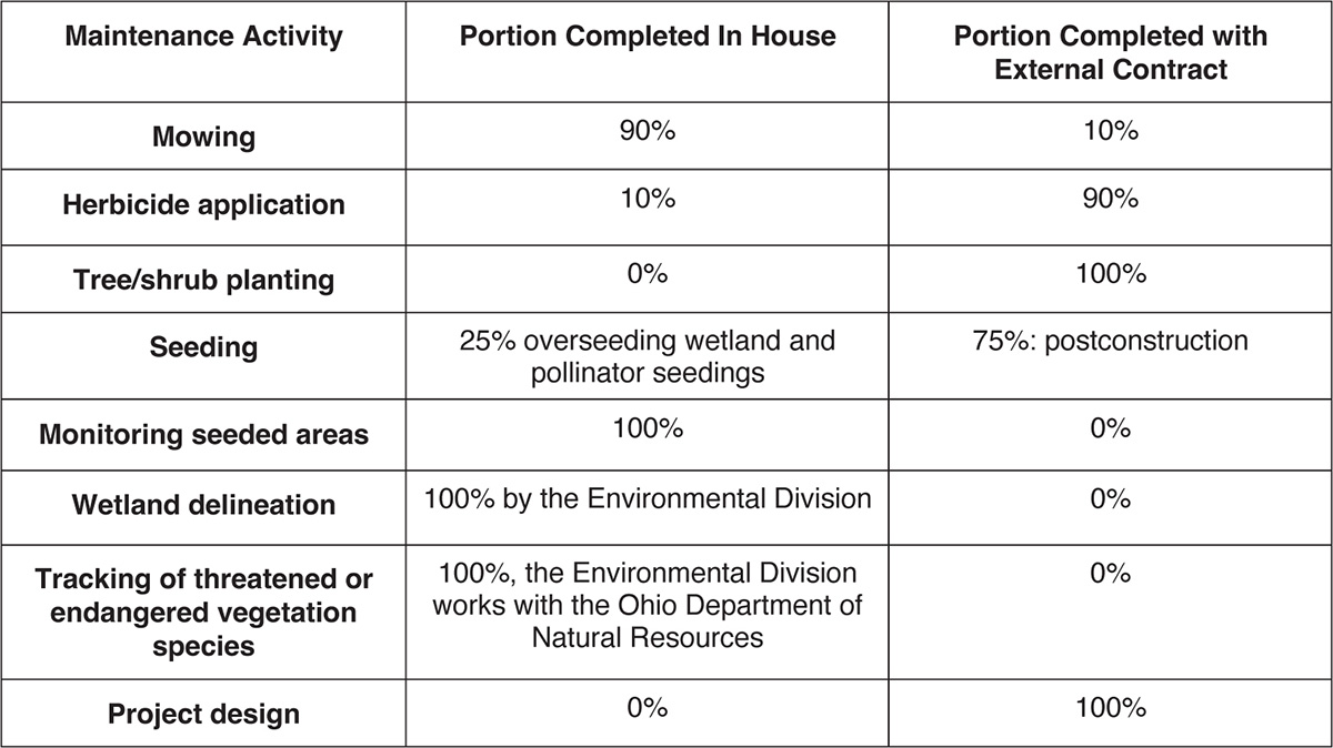
Some districts complete 100% of their herbicide application internally while others employ external contractors to complete their herbicide applications. Districts and counties determine whether mowing will be completed in house or externally on a county-by-county basis based on in-house staffing and availability of appropriate equipment. The statewide percentages can be found in Table B-3.
Long Description.
The column headers of the table are Maintenance Activity, Portion Completed In-House, and Portion Completed with External Contract. The data given in the table row-wise are as follows: Row 1: Mowing: 90 percent; 10 percent. Row 2: Herbicide application: 10 percent; 90 percent. Row 3: Tree or shrub planting: 0 percent; 100 percent. Row 4: Seeding: 25 percent overseeding wetland and pollinator seedings; 75 percent: postconstruction. Row 5: Monitoring seeded areas: 100 percent; 0 percent. Row 6: Wetland delineation: 100 percent by the Environmental Division in conjunction with the Ohio Department of Natural Resources; 0 percent. Row 7: Tracking of threatened or endangered vegetation species: 100 percent; the Environmental Division works with the Ohio Department of Natural Resources; 0 percent. Row 8: Project design: 0 percent; 100 percent.
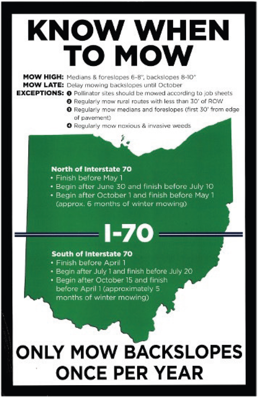
ODOT mowing guidance recommends regularly mowing medians, the first 30 feet from the edge of the pavement, and urban areas, and either mowing or using herbicides to control the growth of noxious and invasive plants. Mowing generally occurs four times per year during the growing season but can be completed more often in urban areas and where sight distance is an issue. Backslopes are mowed only once per year to reduce the negative effect on Monarch butterfly migration patterns. Crews perform routine mowing within immediate areas of the right-of-way during the summer mowing season and an annual mowing of the entire right-of-way and back slopes along all highways during the winter mowing season (Figure B-6). The backslope mowing guidelines preserve protected habitats (by incorporating the Monarch CCAA guidelines) and reduce overall operations costs.
Software and Hardware
Accurately tracking labor and equipment use and associated costs helps ODOT achieve its goal of using data to drive decision-making. Staff upload all information regarding the work and costs so that the central office can review via the software systems. Capturing and analyzing these metrics helps ODOT meet its goals and develop accurate budgets. To this end, ODOT uses multiple software and hardware systems (Table B-4).
EIMS: The Enterprise Information Management System (EIMS) tracks labor, equipment, and work completed in either miles or acreage (depending on the management activity). Crew leaders fill out physical cards each day, detailing the work their crews completed. The county manager reviews this data and sends it to the clerks who enter it into EIMS, and then the county manager reviews it for accuracy (Figure B-7).
Staff can export reports directly from EIMS or they can export the information over to other commercially available software systems in use by ODOT to create more nuanced reports. This information is used to (1) determine whether ODOTʼs county garages are meeting goals throughout the year and (2) develop budgets for the types of work completed. This system has been updated regularly since 2013 to ensure all necessary data is collected, including adding assets.
Long Description.
The text given in the poster is as follows: Mow high: Medians and foreslopes 6 to 8 inches, backslopes 8 to 10 inches. Mow late: Delay mowing backslopes until October. Expectations: 1, Pollinator sites should be mowed according to job sheets. 2, Regularly mow rural routes with less than 30 inches of ROW. 3, Regularly mow medians and foreslopes (first 30’ from edge of pavement). 4, Regularly mow noxious and invasive weeds. North of Interstate 70: Finish before May 1. Begin after June 30 and finish before July 10. Begin after October 1 and finish before May 1 (approx. 6 months of winter mowing). I-70. South of Interstate 70: Finish before April 1. Begin after July 1 and finish before July 20. Begin after October 15 and finish before April 1 (approximately 5 months of winter mowing). The text at the bottom of the poster reads, 'Only mow backslopes once per year.'

Long Description.
The column headers of the table are Tools or Tech Utilized, Assets Impacted, Purpose, Year Use Initiated, Anticipated Lifespan, and System Users. The data given in the table row-wise are as follows: Row 1: EIMS: All assets, Tracking labor, equipment usage, and work completed by individuals, 2013, Updated regularly; County and district staff, central office management. Row 2: Mapping software: All assets; Mapping asset management; Unknown; Updated regularly; Central office management. Row 3: Bi-weekly collector app: All assets; Identifying maintenance needs; 2018; Updated regularly; County and district staff. Row 4: TIMS: All assets; Mapping assets and tracking project status; 2015; Updated regularly; County and district staff, central office management. Row 5: GPS: Snow and ice removal; Tracking snowplows; Unknown; Unknown; County and district staff. Row 6: Tablets: All assets; Mapping activity and structural assets; Unknown; Four years; County and district staff.

Long Description.
The screenshot is titled Work Order Summary. The summary begins with the basic details such as division or cost center, work order number, activity, sub-activity, accomplishment, units, estimate, start date, end date, and comments. Then follows Inv. Element, NLFID, County, Route, Starting MP, Ending MP, Portion Work, and Date. The next segment shows four tabular columns titled Labor, Equipment, Material, and Accomplishments. The end of the information shows data such as labor cost total, labor direct, equipment cost total, equipment direct, material cost total, material direct, contract total, other cost total, work order total, and work order direct.
Mapping software: ODOT uses commercially available mapping software. The enterprise agreement with this company allows ODOT to configure applications specific to the organization, such as the Bi-Weekly Collector App and the Transportation Information Mapping System (TIMS). The central office creates shapefiles using information gathered from the county and district staff. Information is pulled from the Bi-Weekly Collector App and TIMS and made available to ODOT management at the central, district, and county levels.
Bi-Weekly Collector App: The Bi-Weekly Collector App is a geodatabase available on tablets and management staffʼs cellular phones. Each county manager is responsible for driving all DOT-maintained roads within the county every 2 weeks to identify structural and vegetation maintenance needs across the county and inputting work orders into the system. The appʼs large buttons facilitate quick information collection to map maintenance needs and the app allows
managers to upload images of the identified issues. Vegetation with maintenance needs is entered into the system with start and end points. When field staff assigned to maintenance tasks return to the office, they can provide additional comments that can be uploaded into the app by one of the designated users (Figures B-8 and B-9).
The information collected through this application is geospatially recorded and tracked over time. To help ensure information from construction is passed to the maintenance division (e.g., where new or updated assets are located) construction inspectors input assets into the Bi-Weekly Collector App. Per ODOT staff, the system is extremely easy to learn and operate. The system is updated regularly to add assets for tracking. The system has been developed primarily to collect GPS points for where maintenance will need to be completed and does not go into detail about other information (e.g., the equipment or materials needed to complete the work or the size of the area that requires attention).
TIMS: Much of the data in TIMS, the asset management and mapping system, is public facing (Figure B-10). TIMS is used to track inventories, the status of projects, costs, and more. Per ODOT staff, TIMS is a comprehensive software system that necessitates regular operational training for staff to ensure proper use of the system. While it has a steep learning curve, once proficient, staff find the system extremely useful and benefit from the ability to sort information by asset type or ratings.
Asset ratings for items such as culverts are input into the system. This information can inform reports and determine goals for work within the county. Crew leaders are responsible for accessing this system and determining workflow needs for the entire crew.
GPS: GPS/AVL systems are installed on all equipment used for snow and ice removal. This allows staff to know what areas have been treated for snow and ice and when the treatment occurred.
Tablets: Each county has three to four tablets with offline accessibility. These tablets are shared among county staff members, including construction inspectors. Each county manager determines which staff have access to the tablets.
Long Description.
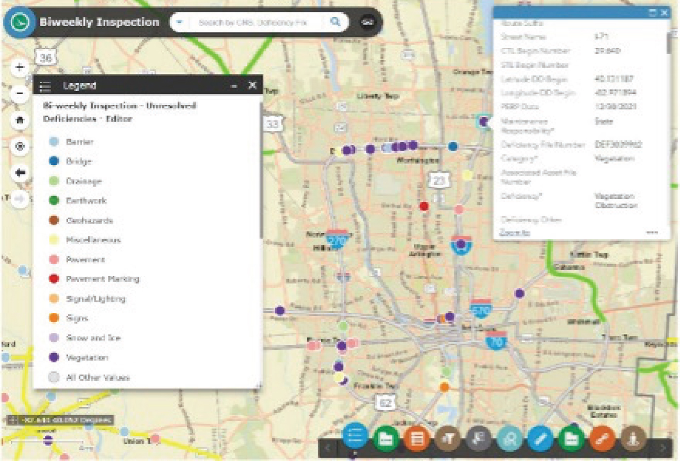
The screenshot is titled 'Biweekly Inspection', followed by a search bar. The legend of the map is titled 'Bi-weekly Inspection - Unresolved Deficiencies - Editor' and lists 13 values. The text in the tables and map is not legible.

Long Description.
The data listed in the table are as follows: Route Suffix: Blank; Street Name: I-71; CTL Begin Number: 29.640; STL Begin Number: Blank; Latitude DD Begin: 40.131187; Longitude DD Begin: Negative 82.971894; PERP Date: 12/30/2021; Maintenance Responsibility asterisk: State; Deficiency File Number: DEF3009962; Category asterisk: Vegetation; Associated Asset File Number: Blank; Deficiency asterisk: Vegetation Obstruction; Deficiency Other: Blank. The end of the table shows the Zoom To option.

Long Description.
The screenshot begins with the heading TIMS. The top row shows options such as Project search, Create a map, Data dashboard, Standard PDF Maps, and Map viewers. The left side of the screenshot shows a legend while the right side shows a map of a section. The data in both sections is not legible.
Implementation
ODOT did not report any issues implementing its roadside vegetation asset management plan at the organizational level due to the cost-saving measures frequently included in the updated guidelines. However, at the local level, field staff sometimes resisted guidance to adjust established practices (e.g., reduce mowing, or other vegetation management guidance updates). However, it was noted that staff are more receptive to maintenance guidelines that come from ODOTʼs central office maintenance operations staff rather than ODOTʼs central environmental office.
Problems with Implementation
When ODOT conducts research to help improve and build on current roadside vegetation asset management practices (e.g., a recent groundcover study that tested seed mixes for pollinator habitat improvement), the organization is slow to implement operational changes. The slow implementation typically results from factors such as infrequent updates to the Construction and Materials Specifications, and technical challenges related to training staff statewide on new procedures. Implementing new software or hardware technology is also challenging because of the integration process, technical challenges related to scaling, deployment across all 13 included assets, large amounts of data such as the current locations of assets and ROW acreages, and many users for software (1,300 staff).
Upcoming Implementation and Tasks
An upcoming urban vegetation management contract will cover Ohioʼs seven largest cities. This work will include tree and brush clearing and herbicide applications within the cities. ODOT staff will continue to perform maintenance on structural assets in these cities.
Conclusions
ODOT is making progress in (1) adopting data-driven operations, technology, and tools and (2) increasing environmental responsibility. The department attributes operational success in part to effective communication among its central office and the individual districts and county-level staff. In addition, ODOT has found that the IT departmentʼs support is necessary for successful implementation.
ODOT has not encountered issues with funding for vegetation management, but they are always seeking ways to keep vegetation maintenance practices as cost-effective as possible. The state supports ODOTʼs mission by authorizing new equipment as needed. ODOT seeks to manage its funding responsibly and invest in resources that improve operations, such as specific software and user-friendly technology. Since 2013, ODOT has been updating asset management software and ensuring that vegetation is included in its asset tracking systems. The Bi-Weekly Collector App allows county managers to ensure vegetation hazards, such as hazard trees, can be included in the work plan for the county alongside structural assets such as bridges and culverts. County staff make the final determination of what maintenance must be performed based on the safety of the traveling public. The use of a simplified application ensures staff are fully trained in the apps and can complete inspections using the statewide platform. Although change management and technical challenges have slowed some efforts to implement changes, ODOT has made significant progress in improving asset tracking and vegetation management efforts.
Tennessee Department of Transportation
About TDOT
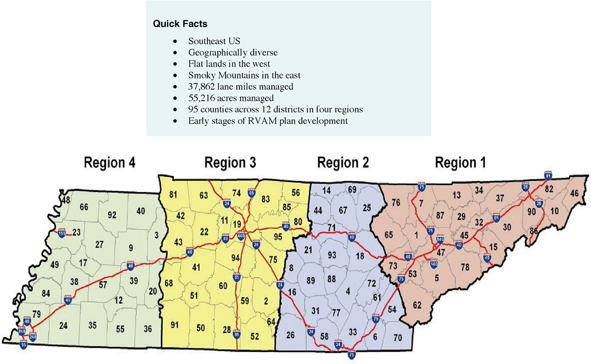
The Tennessee Department of Transportation (TDOT) is responsible for planning, designing, constructing, and maintaining the stateʼs transportation and associated assets, including roadside vegetation assets. TDOT operates a combined centralized and decentralized system with four regions across the state and headquarters in Nashville. Each of the 4 regions is divided into 3 districts for a total of 12 districts across the state (Figure B-11). The central office provides minimum maintenance requirements to the counties and districts. TDOT ensures statewide contracts are in place for the tools and technology used across all counties. TDOT is one of only five debt-free state transportation agencies in the United States. All roadside vegetation asset management is state funded. In 2023, TDOT dedicated 13.5% of its annual budget to vegetation management.
Roadside Asset Management Plans
Internally, TDOT refers to its roadside vegetation asset management plan as the Integrated Vegetation Management (IVM) plan. The IVM plan has not been incorporated into the state TAMP. At present, bridges and pavement are the only assets included in the TAMP. Originally developed in 2016, TDOTʼs IVM plan contains general guidance for vegetation management practices. Staff implemented the IVM plan without issue. TDOT attributes the smooth plan adoption to general guidance included in the plan and minimum state requirements. This allows local staff to conduct management work as needed. A 2020 update is awaiting approval for distribution; however, contractual changes and changes in allowable herbicide formulations must be resolved and integrated before TDOT maintenance staff can implement the updated plan. In addition to the IVM plan, TDOT abides by the United States Fish and Wildlife Service (USFWS) threatened and endangered species requirements.
TDOT or other state government agency staff complete between 30 and 40% of roadside vegetation asset management work in house. TDOTʼs roadside vegetation asset management program uses a combination of in-house and external (contractor-led) labor for asset management.
Long Description.
The state of Tennessee is divided into four regions and numbered from 1 to 4. The map shows a few red lines depicting highways connecting all four regions with two intersections between them. The highways are numbered with the following: 155, 240, 40, 55, 65, 440, 75, 640, 140, and 81. Quick facts in the box on top are southeast US; geographically diverse; flat lands in the west; Smoky Mountains in the east; 37,862 lane miles managed; 55,216 acres managed; 95 counties across 12 districts in four regions; early stages of RVAM plan development
Roadside Vegetation Asset Management
TDOTʼs IVM plan requires two cycles of 15-foot-wide mowing swaths two times per year. These occur at the beginning and ending of the growing season. Urban areas are mowed more frequently for travelersʼ safety. Regions, districts, or counties can require additional mowing cycles to be completed each year. Often, additional mowing is completed around holidays (Figure B-12).
Herbicides are purchased pre-blended to increase TDOT staff safety and eliminate staff having to determine proper mixture procedures. The IVM plan includes guidance about when, where, how, and under what circumstances these blends can be used.
The Tennessee Department of Environment and Conservation (TDEC) defines areas that cannot receive maintenance activities or have special requirements for mowing and herbicide application. These areas include pollinator plots, wetlands, and other sensitive environmental areas. TDEC reviews all new maintenance areas to ensure compliance with environmental laws. The local IVM plan does not provide guidance for sites selected by TDEC for special maintenance requirements. TDEC provides guidance for maintenance in these areas when needed. Field signs can be used to identify sites in need of specialized management, but this is mostly managed through staffʼs memories (Figure B-13).
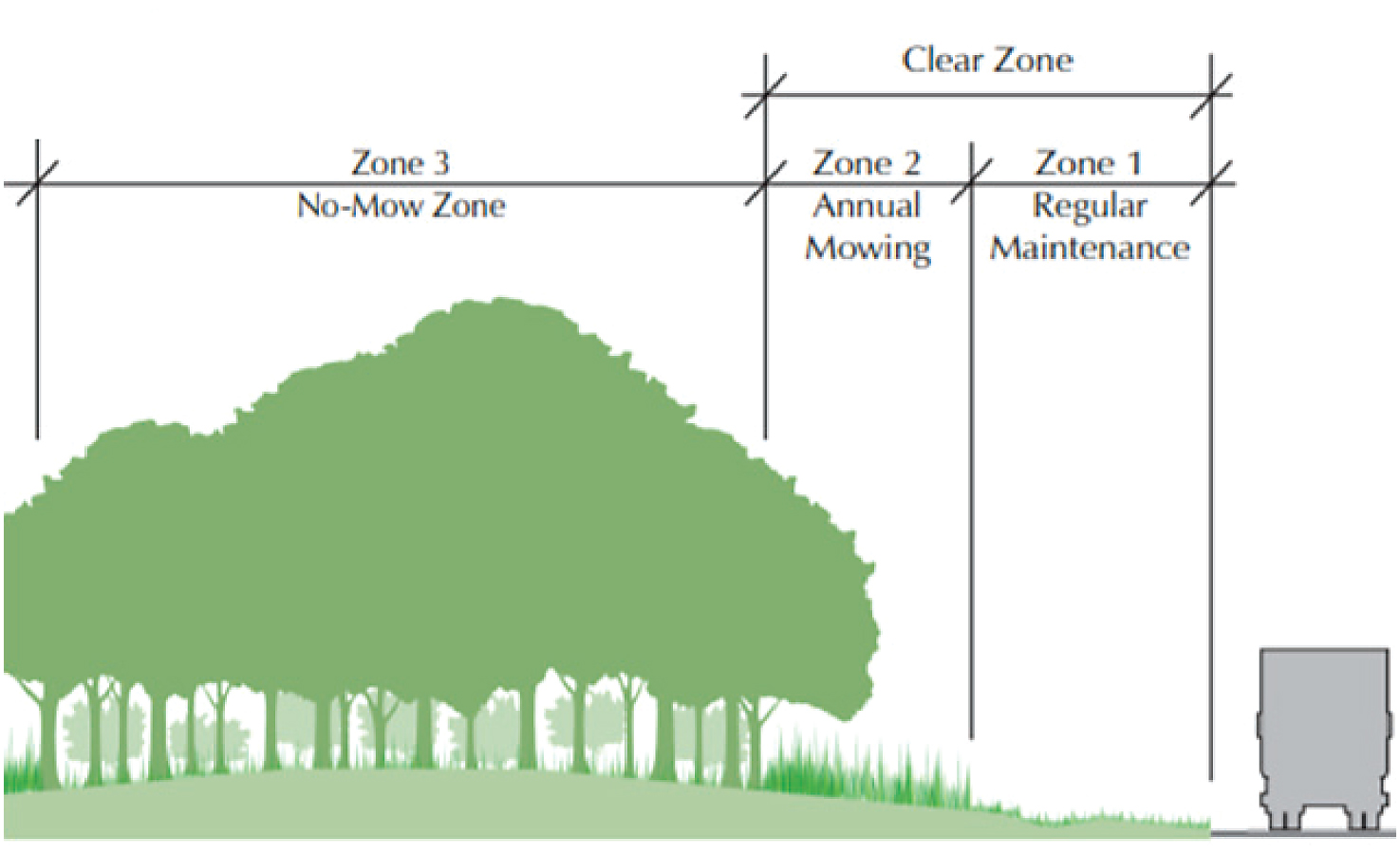
TDOT removes trees as needed. There is a shift toward managing trees more proactively—TDOT has contracted with a mapping software company to map trees along the roadside. This will enable TDOT to identify areas where routine tree maintenance can help prevent trees from falling onto the road.
Long Description.
The illustration shows a dense forest with large trees. Next to the trees are areas with shorter plants and grass. The region with trees is marked 'Zone 3: No-Mow Zone.' The region with shorter plants and grass together is marked 'Clear Zone.' The region with shorter plants is marked 'Zone 2: Annual Mowing.' The region with grass is marked 'Zone 1: Regular Maintenance.'

Long Description.
A highway with a signboard that reads, 'Herbicide Test Pilot. DO NOT MOW. March 1, 2021, to February 28, 2022. 38A' along a four-lane highway.
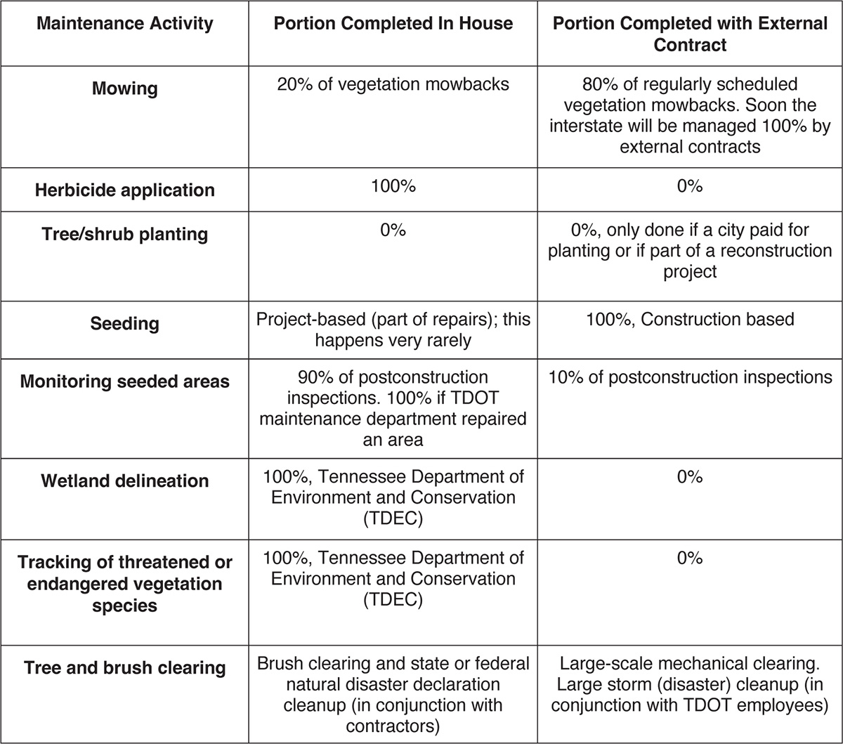
Table B-5. Internal maintenance versus contracted maintenance activities within TDOT.
Long Description.
The column headers of the table are Maintenance Activity, Portion Completed In-House, and Portion Completed with External Contract. The data given in the table row-wise are as follows: Row 1: Mowing: 20 percent of vegetation mow-backs; 80 percent of regularly scheduled vegetation mowbacks. Soon, the interstate will be managed 100 percent by external contracts. Row 2: Herbicide application: 100 percent; 0 percent. Row 3: Tree or shrub planting: 0 percent; 0 percent; only done if paid by the city or if part of the reconstruction project. Row 4: Seeding: Project-based (part of repairs); this happens very rarely; Construction-based, 100 percent. Row 5: Monitoring seeded areas: 90 percent of postconstruction inspections. 100 percent if the TDOT maintenance department repaired an area; 10 percent of postconstruction inspections. Row 6: Wetland delineation: 100 percent; Tennessee Department of Environment and Conservation (TDEC); 0 percent. Row 7: Tracking of threatened or endangered vegetation species: 100 percent; Tennessee Department of Environment and Conservation (TDEC); 0 percent. Row 8: Tree and brush clearing: Brush clearing and state or federal natural disaster declaration cleanup (in conjunction with contractors); Large-scale mechanical clearing. Large storm (disaster) cleanup (in conjunction with TDOT employees).
TDOT is reviewing which maintenance items will be redistributed from in-house completion to contracts with parties outside of the Tennessee State Government (Table B-5).
Software and Hardware
TDOT uses statewide contracts to provide tools and technology for vegetation management and vegetation safety asset management (Table B-6). TDOT has a goal of accurately mapping needed maintenance and using that collected data to drive decision-making.
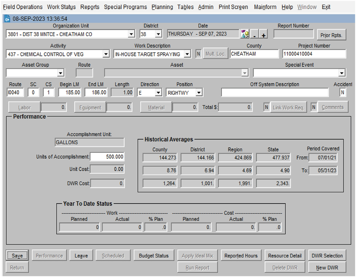
MMS: TDOTʼs Maintenance Management System (MMS) tracks maintenance requests, staff time, and the status of maintenance activities. The MMS is a proprietary system developed exclusively for TDOT (Figure B-14). The MMS is supplemented by external tracking spreadsheets. This system includes a large amount of information and requires an average of 4 days of training to ensure proficiency.
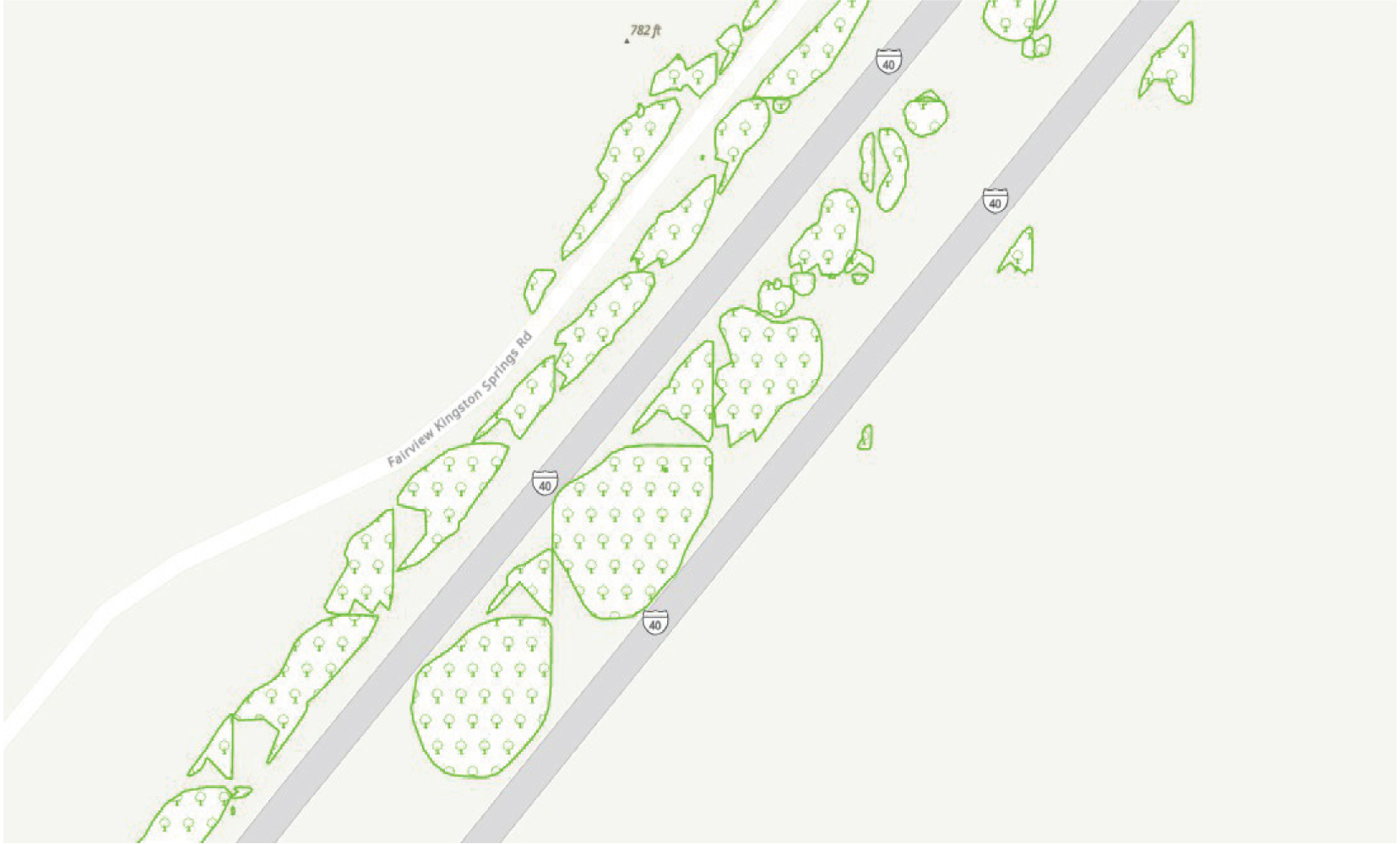
Street-level, high-resolution imagery: TDOT relies on third-party imagery for internal mapping efforts. A contractor uses vehicles fitted with 360-degree cameras to capture images, which are interpreted using AI software (Figure B-15). The contractor provides updated images for the state once per year. During data collection periods, all trees within 15 feet of state-maintained roads are geolocated and analyzed using both LiDAR point clouds and high-resolution imagery. Rendered data deliverables are uploaded to online image viewer software, at which point TDOT can download and overlay the information onto its mapping software to identify trees that need maintenance or removal. TDOT staff use digital information in conjunction with paper maps and knowledge of site management history to schedule statewide maintenance work.
Long Description.
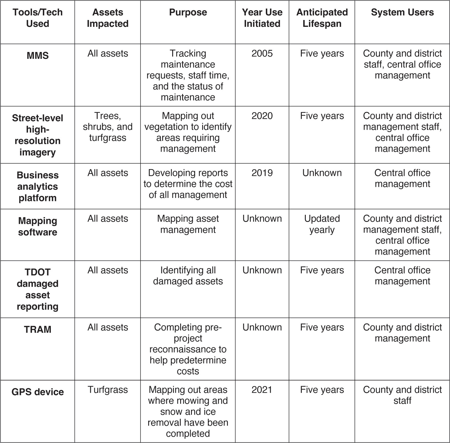
The column headers of the table are Tools or Tech Utilized, Assets Impacted, Purpose, Year Use Initiated, Anticipated Lifespan, and System Users. The data given in the table row-wise are as follows: Row 1: MMS: All assets; Tracking maintenance requests, staff time, and the status of maintenance; 2005; Five years; County and district staff, central office management. Row 2: Street-level high-resolution imagery: Trees, shrubs, and turfgrass; Mapping out vegetation to identify areas requiring management; 2020; Five years; County and district management staff, central office management. Row 3: Reporting software: All assets; Developing reports to determine the cost of all management; 2019; Unknown; Central office management. Row 4: Mapping software: All assets; Mapping asset management; Unknown; Updated yearly; County and district management staff, central office management. Row 5: TDOT Damaged Asset Reporting: All assets; Identifying all damaged assets; Unknown; Five years; Central office management. Row 6: TRAM: All assets; Completing pre-project reconnaissance to help predetermine costs; Unknown; Five years; County and district management. Row 7: GPS device: Turfgrass; Mapping out areas where mowing and snow and ice removal have been completed; 2021; Five years; County and district staff.
Business analytics platform: TDOTʼs business analytics platform is a commercially available tool that allows TDOT management staff to determine the cost of management across the state accurately. This software enables cost information to be manipulated so that users can access data for specific areas of the state and for specific tasks.
Mapping software: All in-house mapping uses shapefiles and publicly available baseline imagery. Shapefiles from the contractor are downloaded from the website image viewer and imported into commercially available mapping software (Figures B-16 and B-17). After this is completed, TDOT employees can retrieve the map.
TDOT Damaged Asset Reporting: TDOT uses this app for collecting information on damaged vegetation-related safety features (e.g., guardrails, cable rails, and attenuators). Staff indicate the date information is received, the completion date, priority level, region, county, route type, route, direction, mile, GPS point, and any other identifying information.
TRAM: The TDOT Roadside Asset Map (TRAM) is used for pre-project reconnaissance to help determine costs within the Asset Management Division.
GPS units: TDOT trucks are installed with GPS units to collect data for mapping software and to track specific equipment.
Long Description.
The first row of the screenshot shows options such as field operations, work status, reports, special programs, planning, tables, admin, print screen, mainform, help, window, and exit. The data listed in the screenshot are operational unit, district, date, report number, activity, work description, county, project number, asset group, route, asset, special event, route, SC, CS, begin LM, end LM, length, direction, position, off system description, accident, performance, historical averages, and year to date status. The bottom of the page shows options including save, leave, budget status, reported hours, resource detail, DWR selection, and new DWR.

Long Description.
The map view shows a diagonal pathway in the northeast direction with an arrow pointing along the way. The photo shows the high-resolution imagery of the same location from a vehicle's perspective.
Long Description.
The map shows an aerial view of two parallel routes in the northeast direction. Along the routes are several regions with dense tree growth. These regions are represented with green markings and are scattered along the interstate route.
Long Description.
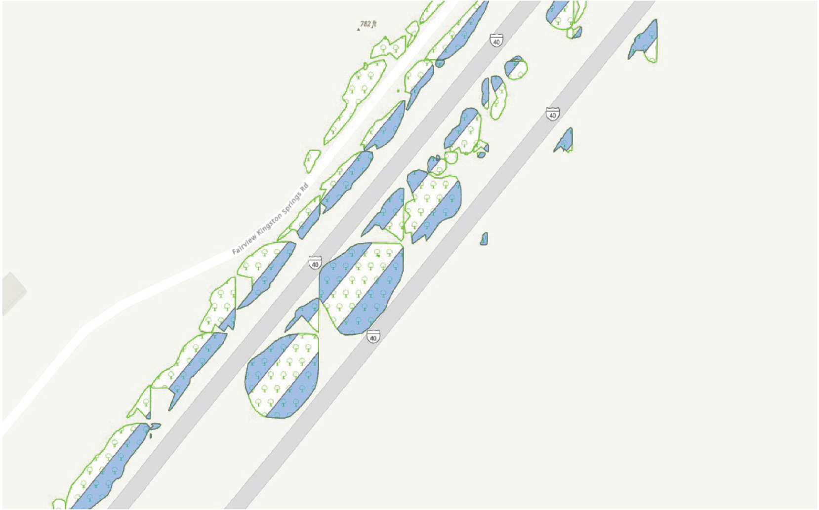
The map shows an aerial view of two parallel routes in the northeast direction. Along the routes are several regions with dense tree growth. These regions are represented with green markings and scattered throughout the interstate route, on either side. The areas to be removed are shaded in blue within the tree regions. Around 50 percent of the region is required for removal.
Implementation
TDOT did not report any issues implementing its roadside vegetation asset management plan. TDOT is continually refining its implementation of the IVM plan and subsequent contracts based on the planʼs strengths and weaknesses the department has learned over the past 10 years. The general language of the IVM plan allows counties to adapt the plan to their local needs, which reduces local pushback on plan updates and implementation.
All staff are trained in the MMS. For over 15 years, TDOT has kept track of staff time, broad maintenance activities, and resident complaints in one program.
As technology has progressed, mapping applications that integrate street-level, high-resolution imagery are used broadly for both personal and professional use through cellular devices, tablets, and computers. The use of these mapping applications means many staff members are familiar with the information provided by such mapping software. TDOT uses street-level, high-resolution imagery to map the ROW. The current maps are more detailed than previous versions, focus exclusively on areas that the counties maintain, and have a 360-degree view of the roadside right-of-way. Since the contractor maps the state at approximately the same time every year, TDOT can easily compare the effectiveness of management efforts over time (e.g., in controlling invasive plant species, trees, and brush).
Problems with Implementation
TDOTʼs IVM plan includes only commonly used management practices. The plan does not provide potentially necessary specifications to implement specialized management (e.g., the management of wetlands or T&E species). If specialized management is needed, TDEC provides guidance to staff.
A challenge of the MMS is that the system is not user-friendly, and the developer stopped providing software support in 2007, so software updates are no longer available. Some drawbacks to the outdated system include the fact that managers cannot easily reschedule maintenance activities. TDOT is working on issuing a Request for Proposal (RFP) for a program to replace the MMS.
A downside of the street-level, high-resolution imagery system is that it is not integrated with the MMS. The IT department does not have enough staff for every maintenance staff member to have log-in credentials for the TDOT system or access to electronic devices in the field. This prevents field staff from using a tablet, phone, or other electronic device to access maps, which means that much information collected for management purposes is not used by field staff as desired. TDOT is working to increase technology access for staff.
Upcoming Implementation and Tasks
TDOT is planning to replace the MMS soon. TDOT is awaiting permission from upper management to issue an RFP for this replacement. Leadership anticipates a 5-year lifespan for the next system. The department is working to purchase and install GPS units in all mowers in addition to the field vehicles. This will enable TDOT to determine accurate mowing acreage across the state. Once the information is collected, the shapefiles will be used to update the statewide mapping system with accurate information.
TDOT is designing an in-house training program with required hours across all aspects of the job. Each staff member will be required to complete this training annually. The training will
include classroom and field elements with exams that include core competencies and electives. Employees will be able to choose elective courses to increase their knowledge of selected topics.
Conclusions
TDOTʼs generalized IVM plan balances structure with flexibility and autonomy—counties and districts can perform work in the manner that they need. The department is investing in technology and training to enhance operations and actively looking for further ways to improve.
TDOTʼs statewide contracts, which specify requirements to ensure proper data type and quantity collection measures, have been beneficial for TDOTʼs vegetation management operations. Statewide contracts for most hardware and software needs allows for standardized training and ease of use between staff from different counties. Street-level, high-resolution imagery can be used across both vegetation and structural assets.
TDOT completes work in house and through contractors to ensure that it can efficiently manage vegetation across the state and that the most qualified individuals complete the needed work. For instance, TDOTʼs tree removal process uses contractors for large-scale scheduled removals, but TDOT staff respond to small brush or tree hazards along the roadway.
As TDOT continues to update its systems, it is looking to create a training program that will increase promotion potential for staff within the organization and allow staff to focus on specializations as desired.
Washington State Department of Transportation
About WSDOT
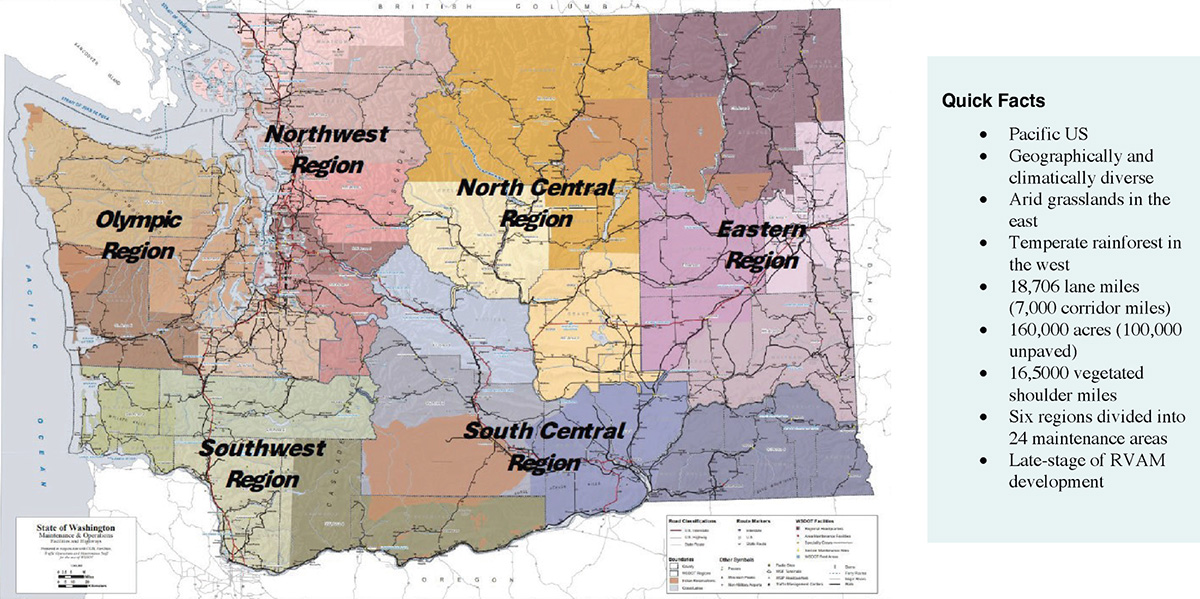
The Washington State Department of Transportation (WSDOT) central Maintenance Operations Office administers policy and practice in Olympia under the direction of WSDOTʼs principal landscape architect for roadside maintenance. The departmentʼs structure is centralized, coordinating management of 24 maintenance areas within six regions across the state (Figure B-18).
WSDOT uses state funding for vegetation management activities. Nearly 100% of roadside vegetation asset management work is completed in house by WSDOT staff following construction and a plant establishment period, which are accomplished through private contracts. The only externally completed vegetation maintenance work is through Adopt-a-Highway or by special permit to neighboring landowners.
WSDOT operates with a budget developed every other year, and between 2021 and 2023, vegetation management received 6% of the overall budget for maintenance operations. In 2022, this amounted to $25 million for roadside vegetation asset management operations.
Roadside Asset Management Plans
Each of the 24 maintenance areas has a dedicated Integrated Roadside Vegetation Management (IRVM) plan. WSDOTʼs roadside vegetation asset management system is being incorporated into the state TAMP. This plan, originally published in 2018, is undergoing executive review and revision. The TAMP details an agency strategy for all state transportation assets. This document describes the historic and current condition of the system and includes an estimate of the funding required to restore all 100,000 acres to optimal condition. While FHWA requires state TAMPs to include only bridges and pavement, WSDOT has added 10 classes of
Long Description.
The WSDOT maintenance regions are divided into six major regions and colored. They are as follows: Northwest Region, North Central Region, Eastern Region, Olympic Region, Southwest Region, and South Central Region. Native American lands are shown with brown overlays in each of the six major regions. Quick facts box on right shows Pacific US; geographically and climatically diverse; arid grasslands in the east; temperate rainforest in the west; 18,706 lane miles (7,000 corridor miles); 160,000 acres (100,000 unpaved); 16,500 vegetated shoulder miles; six regions divided into 24 maintenance areas, and late-stage of RVAM development
transportation assets to its TAMP (e.g., roadside land use, culverts, signs, roadway delineation signs, and chronic environmental deficiencies). WSDOT vegetation management is completed using a zonal approach (Figure B-19).
Roadside Vegetation Asset Management
The initial formation of WSDOTʼs roadside vegetation asset management resulted from the 1993 Programmatic Environmental Impact Statement (EIS) on Roadside Vegetation. WSDOT voluntarily conducted the EIS in response to public and legislative concerns over roadside herbicide use and formal landscape maintenance.
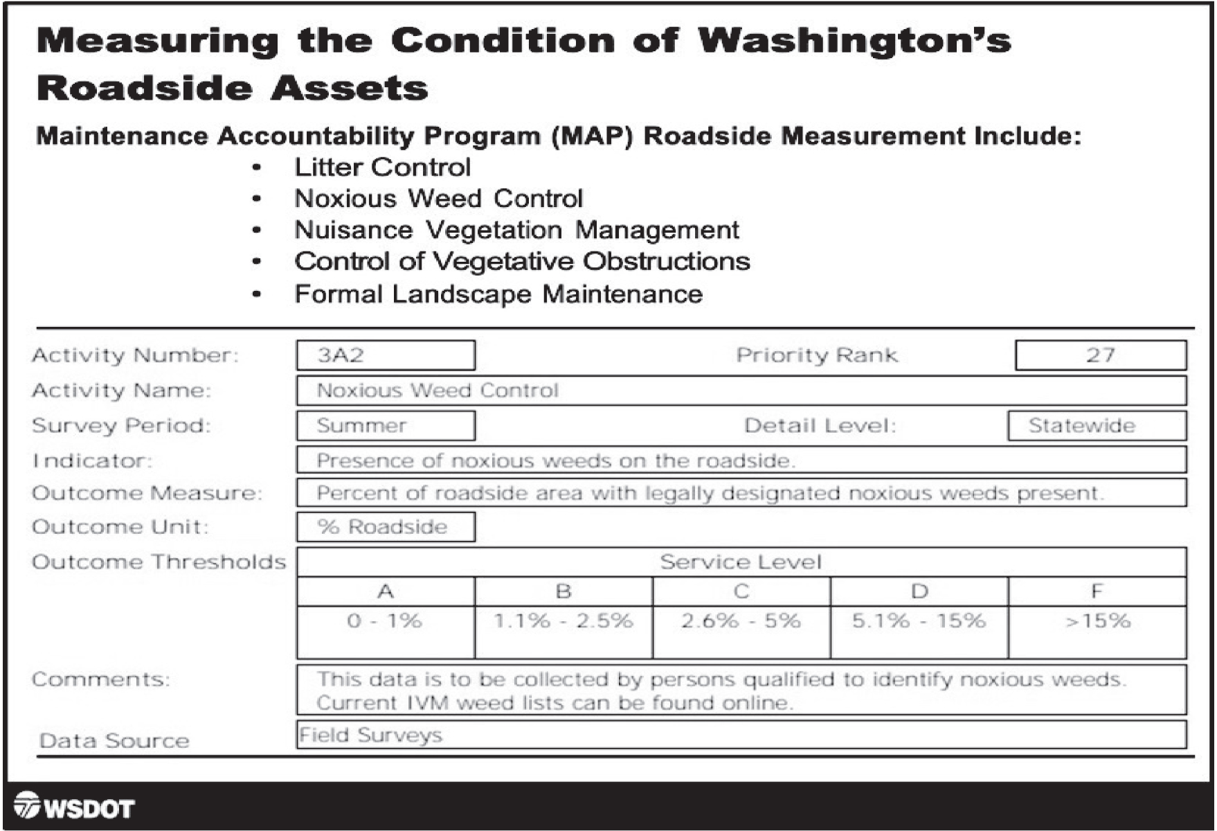
The Maintenance Accountability Program (MAP) was originally implemented in 1998. MAP outlines highway maintenance activities and their associated location, size, and cost and describes the levels of service provided by WSDOT maintenance operations. MAP activities for roadside land use include control of litter and vegetation obstructions, noxious weed control, nuisance vegetation control, and formal landscape maintenance (Figure B-20).
Planned treatments for each measured activity are described in the 24 annually updated maintenance area IRVM plans. IRVM plans describe the number of acres to be treated for each activity and provide detailed prescriptions for mowing, herbicide use, and other integrated vegetation management treatments. These plans also call out locations within each area where special treatment is required (e.g., newly constructed roadside sections, areas being cleaned and restored following the removal of encampments, and environmentally sensitive areas).
Accomplishments of the IRVM plans are recorded throughout the year in the Highway Activity Tracking System (HATS) and Financial Reporting System (FIRS) by area maintenance staff.

Long Description.
The illustration shows a few coniferous trees and bushes on a slope rising from the right side of the road. A car and a bicycle are on the road. The region right below the road is marked Pavement, followed by Roadway. Towards the right of the roadway region, the sidewalk and the area of vegetation are divided into three zones. They are as follows: 1, Vegetation Free Zone (may or may not be present): Gravel Shoulder. Maintained in designated locations using mechanical and chemical methods for sight distance, to improve drainage, and to preserve pavement and roadside hardware. 2, Operational Zone: Low Vegetation. Maintained with mowing and IVM treatments for sight distance, safe errant vehicle recovery, and weed control. 3, Buffer Zone: Native or Natural Vegetation. Where adequate right of way exists, maintained using IVM to encourage desirable vegetation in self-sustaining plant communities.
Software and Hardware
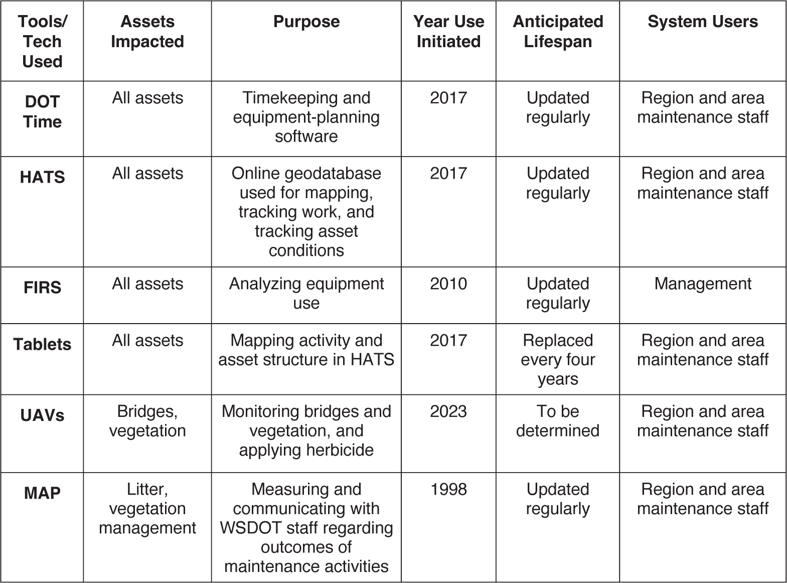
In recent years, software and hardware applications have been adapted and developed to supplement planning and tracking roadside vegetation asset management activities. WSDOT uses OTS platforms to develop and maintain the departmentʼs software programs (Table B-7).
DOT Time: This is WSDOTʼs proprietary management software for tracking labor, material, and equipment costs. All WSDOT employee time and activity types are tracked through this system. Following the inclusion of the data within DOT Time, information is extracted into FIRS. DOT Time, initially developed in the early 1990s, is used by regional and area field staff to manage budgets.
Long Description.
The screenshot is titled 'Measuring the Condition of Washington's Roadside Assets.' The text below reads, Maintenance Accountability Program (MAP) Roadside Measurement includes: Litter control, Noxious weed control, Nuisance vegetation management, Control of vegetative obstructions, and Formal landscape maintenance. Below the text, data in the form of a worksheet is given. Data are as follows: Activity number: 3A2. Priority rank: 27. Activity name: Noxious weed control. Survey period: Summer. Detail level: Statewide. Indicator: Presence of noxious weeds on the roadside. Outcome measure: Percent of roadside area with legally designated noxious weeds present. Outcome unit: Percent roadside. Outcome thresholds: Service level: A 0 to 1 percent, B 1.1 to 2.5 percent, C 2.6 to 5 percent, D 5.1 to 15 percent, and F greater than 15 percent. Comments: This data is to be collected by persons qualified to identify noxious weeds. Current IVM weed lists can be found online. Data source: Field surveys.
Long Description.
The column headers of the table are Tools or Tech Utilized, Assets Impacted, Purpose, Year Use Initiated, Anticipated Lifespan, and System Users. The data given in the table row-wise are as follows: Row 1: DOT Time: All assets; Timekeeping and equipment-planning software; 2017; Updated regularly; Region and area maintenance staff. Row 2: HATS: All assets; Online geodatabase used for mapping, tracking work, and tracking asset conditions; 2017; Updated regularly; Region and area maintenance staff. Row 3: FIRS: All assets; Analyzing equipment use; 2010; Updated regularly; Management. Row 4: Tablets: All assets; Mapping activity and asset structure in HATS; 2017; Replaced every four years; Region and area maintenance staff. Row 5: UAVs: Bridges, vegetation; Monitoring bridges and vegetation, and applying herbicide; 2023; To be determined; Region and area maintenance staff. Row 6: MAP: Litter, vegetation management; Measuring and communicating with WSDOT staff regarding outcomes of maintenance activities; 1998; Updated regularly; Region and area maintenance staff.
HATS: The Highway Activity Tracking System (HATS) is a proprietary configuration of a commercially available mapping tool. This system enables mapping and tracking of planned and completed work. HATS was developed by one full-time developer for web support, one full-time developer for technology support (industry-leading mobile tablets), and a part-time employee for mapping—all from the IT department. Ongoing development, management, and crew training is supported by five staff members in the central Maintenance Operations Office.
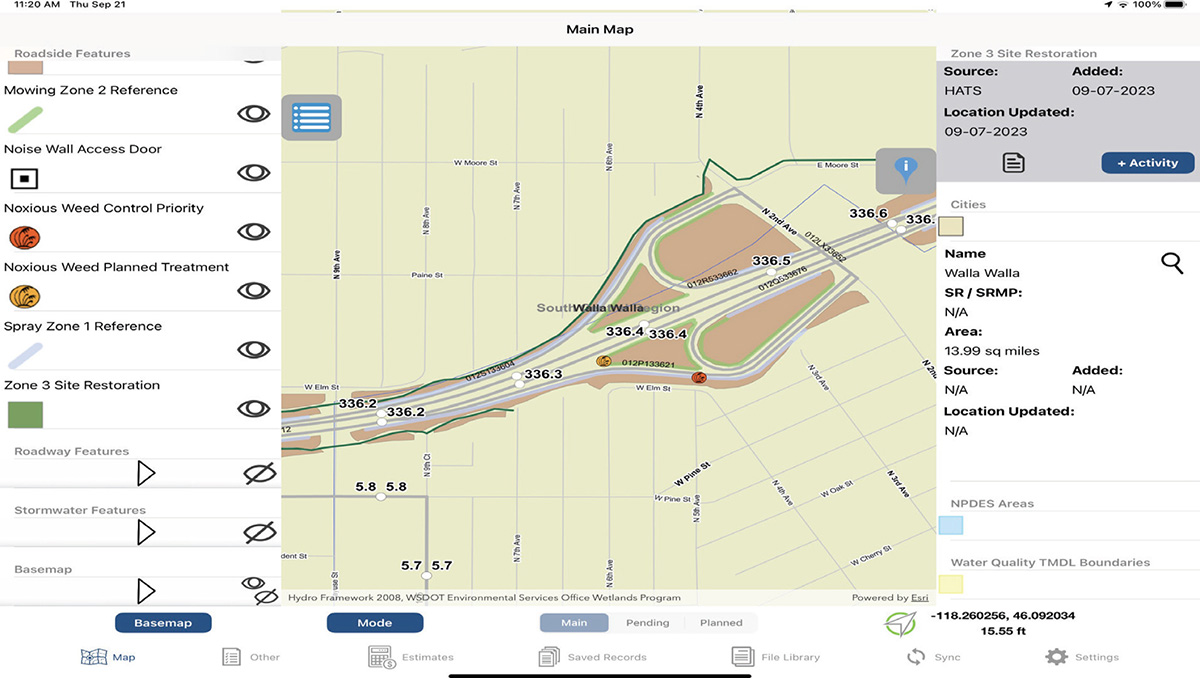
As DOT staff develop and complete right-of-way projects, staff document the type, size, and location of projects in HATS (Figures B-21 and B-22). Each maintenance staff member can view and record activity information through their assigned tablet. The implementation of HATS is credited with improving accountability, communication, documentation, and ownership of projects, which has in turn improved staff morale and retention. In total, this in-house program costs an average of $350,000 per year in staffing support and $80,000 per year for licensing the mapping software for tablets.
FIRS: WSDOT staff use FIRS, a proprietary system, to record and analyze data from DOT Time to track labor as well as equipment costs, material costs, conditions, and use. FIRS helps staff identify underused equipment, which can be flagged for replacement or moved to another department. Regional staff use this system to plan and age budgets every other year, and the central office uses it to explain operational costs and logistics to the legislature.
Tablets: WSDOT uses tablets to reference planned activities and track acreage and staff productivity in the field. The department has approximately 1,300 tablets in circulation and replaces

Long Description.
The screenshot shows the main map with two text boxes on top. The top text box, titled 'History - WSDOT00001242680' shows data such as activity, orgcode, name, and comments. The second text box , which covers the bottom of the top text box is titled, 'History - WSDOT00001242680' and shows data such as activity, apron or footing, can you see through to the other end of the culvert, corrosion, cracking, and cross section deformation. The right side of the main map shows the WSDOT ID, SR or SRMP, length, source, added, and location updated.
Long Description.
The screenshot shows the main map showing the route of MP 336.2 to MP 336.6. On either side of the main map are two sections. The section on the left lists data of mowing zone 2 reference, noise wall access door, noxious weed control priority, noxious weed planned treatment, spray zone 1 reference, and zone 3 site restoration. The section on the right lists source, added, location updated, name, SR or SRMP, area, source, added, and location updated.
each tablet every 4 years, with a total annual cost of approximately $228,000. The hardware that supports the tabletsʼ wireless internet connection to the central system costs $30,000 per year and is updated on a 6-year cycle.
UAVs: WSDOT has begun using unmanned aerial vehicles (UAVs) via private contractors to plan and carry out herbicide applications and monitor vegetation cover. This type of application allows for the cost-effective treatment of weed infestations over large areas that would not be possible with ground-based equipment. An added benefit of UAV use is improved worker safety through reduced traffic exposure. Because this work is being done by private contractors in place of WSDOT employees with traditional equipment, the arrangement was cleared with the labor union to ensure that no union labor was lost.
WSDOT is investigating expanding UAV use for aerial herbicide application, seeding in dangerous areas, mapping sites during and after construction, spray painting over graffiti in hard-to-reach locations, and incorporating multispectral imaging and LiDAR for the evaluation of bridges and roadside structures.
Implementation
WSDOT is committed to improving operations and asset management to meet statewide goals as well as financial and sustainability targets. Planning and strategy, technology acquisition and expansion, and staff training are all critical components of implementing plans and systems that will help WSDOT effectively meet its mission.
Problems with Implementation
When the roadside vegetation asset management plan was developed, WSDOT encountered such challenges as the following:
- Some employees were not comfortable with technology and the accountability that comes with detailed daily tracking of work activities.
- Recruiting and retaining management staff who prioritized the use of asset management systems and were comfortable developing and using the technology was a challenge.
- Because the systems were independently created, getting them to communicate with one another was challenging.
- IT staff being able to work with management and maintenance field staff to ensure the tablets and recorded data function with the various systems.
These issues were resolved by employee training and by incorporating new technology immediately into the jobs of new WSDOT staff. As staff turnover occurred, newer staff had a higher level of comfort with the equipment. As changes were adopted, WSDOT was able to demonstrate benefits to staff and management, which increased internal support for new technology being used by field crews. The final element for the success of the roadside vegetation asset management program was supportive and consistent staff who stayed with the program throughout development.
Upcoming Implementation and Tasks
The next step for the full implementation of WSDOTʼs roadside vegetation asset management will be to develop an accurate and complete map of all planned maintenance activities as described in the 24 area IRVM plans. The current treatment features include edge lines, weed infestation points, and polygons for large-area landscape restoration treatments. However, these mapped features only serve as a rough sketch in reference to the plans. Additional full-time staff are needed to maintain an annually updated set of lines, points, and polygons that accurately represent the amount and types of work included in the area plans. Once this process of annual feature mapping is in place, HATS can be used to create pending work plans for crews and help direct priority timing and location of required vegetation management work.
Conclusions
WSDOT has successfully embraced technology and a centralized organizational structure to improve vegetation management and maintenance outcomes. It has also identified opportunities for further growth and improvement.
Over the past 6 years, using the combination of data from the 24 area IRVM plans, HATS, FIRS, and MAP, WSDOT has been able to explain the costs and resulting conditions from roadside vegetation asset management. This data shows that historic and current funding levels for roadside vegetation maintenance have resulted in a declining state of repair for roadside assets throughout the state.
WSDOTʼs strategy moving forward as described in its roadside vegetation asset management plan is to use this data to show what would be required to restore the state highway roadsides to optimal condition in the years ahead. The roadside vegetation asset management system will allow the agency to make a credible argument for adequate legislative funding for transportation system maintenance and preservation. The system will also allow the agency to demonstrate where success in restoring roadside conditions is being accomplished through credible documentation of case study locations throughout the state.
Wisconsin Department of Transportation
About WisDOT
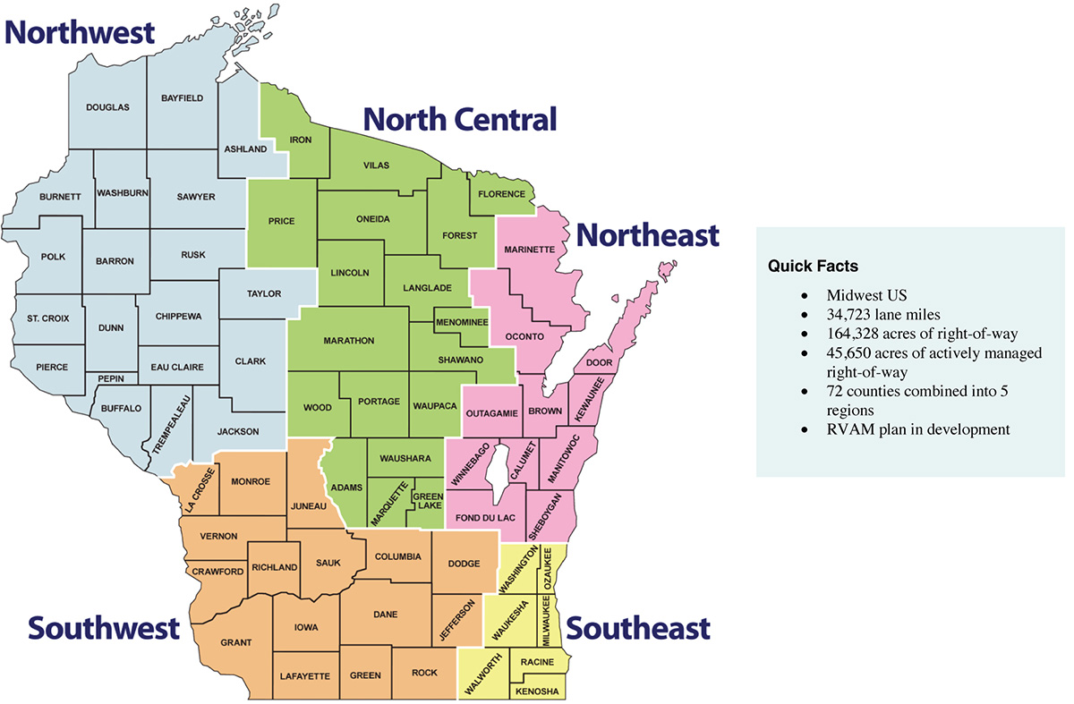
The Wisconsin Department of Transportation (WisDOT) is responsible for planning, development, maintenance, and regulation of transportation infrastructure, including vegetation management, in the state of Wisconsin. The agencyʼs structure operates with a combined centralized and decentralized system. Within this structure, the Division of Transportation System Development (DTSD) oversees development, maintenance, and operations functions related to the state highway system. The division manages statewide bureaus and five regional operations that consist of 72 counties (Figure B-23). The statewide bureaus advise the regional offices and monitor the quality and efficiency of the departmentʼs programs. The five regions manage the operation and development of state highways and maintain working relationships with local units of government. WisDOT contracts with county government agencies (county highway departments) to perform highway maintenance work in their respective counties. The counties follow WisDOTʼs maintenance policies, and the regions work with the counties to manage budgets and priorities. WisDOTʼs contracting with county highway departments is unique. With 72 counties to coordinate and no ownership of equipment, WisDOT has different requirements than many transportation agencies across the country.
Of the total highway program budget, approximately 13.5% is allocated to maintenance operations. Of this, approximately 17% is spent on roadside maintenance, including mowing, woody
Long Description.
The state of Wisconsin is divided into five regions as follows. The North Central region consists of Adams, Florence, Forest, Green Lake, Iron, Langlade, Lincoln, Marathon, Marquette, Menominee, Oneida, Portage, Price, Shawano, Vilas, Waupaca, Waushara and Wood counties. The Northwest region consists of Ashland, Barron, Bayfield, Buffalo, Burnett, Chippewa, Clark, Douglas, Dunn, Eau Claire, Jackson, Pepin, Pierce, Polk, Rusk, Sawyer, St. Croix, Taylor, Trempealeau and Washburn counties. The Northeast region consists of Brown, Calumet, Door, Fond du Lac, Kewaunee, Manitowoc, Marinette, Oconto, Outagamie, Sheboygan and Winnebago counties. The Southwest region consists of Columbia, Crawford, Dane, Dodge, Grant, Green, Iowa, Jefferson, Juneau, La Crosse, Lafayette, Monroe, Richland, Rock, Sauk and Vernon counties. The Southeast region consists of Kenosha, Milwaukee, Ozaukee, Racine, Walworth, Washington and Waukesha counties. Quick facts box on the right shows midwest U S; 34,723 lane miles; 164,328 acres of right-of-way; 45,650 acres of actively managed right-of-way; 72 counties combined into 5 regions; and RVAM plan in development.
vegetation control, litter removal, and herbicide applications. Driven by WisDOTʼs natural roadside philosophy and budget constraints, WisDOTʼs roadside vegetation asset management involves leaving much of the land owned by the DOT in a natural vegetation state with no maintenance.
WisDOT has two landscape architects with the Bureau of Highway Maintenance (BHM) that operate from the central office. These landscape architects support all parts of the department even though they are based in the BHM. At WisDOT, roadside vegetation asset management focuses on maintenance tasks that affect safety, operation, and function over aesthetic priorities.
Roadside Asset Management Plans
WisDOT does not have a fully developed roadside vegetation asset management plan. In the early 1990s, as part of an effort to find high-quality roadsides, the department began inventorying roadside vegetation to identify roadside remnant prairies. This data was used as a baseline to develop an IVM plan. WisDOT inventoried approximately one-third of the highway lane miles before funding ceased. Since then, the department has also inventoried vegetation safety features (e.g., living snow fences).
Roadside vegetation asset management activities have not been incorporated into the state TAMP, which only includes bridges and pavement. Instead, the roadside maintenance tasks to be completed by counties on state highways are identified in Chapter 7 of WisDOTʼs Highway Maintenance Manual.
WisDOT has enrolled roadside acreage in the Monarch CCAA and the U.S. Army Corps of Engineers 404 Wetland Mitigation program. WisDOT documents the status of these locations with specified monitoring points. It has begun tracking management areas with GIS but has not yet completed an analysis or status of these areas.
Roadside Vegetation Asset Management
Vegetation management is primarily driven by funding, while maintenance for structural assets is guided by the Highway Maintenance Manual (HMM). The BHM landscape architects work with outside experts, such as the Department of Natural Resources (DNR) and University of Wisconsin extension staff, to help identify new occurrences of invasive plant species.
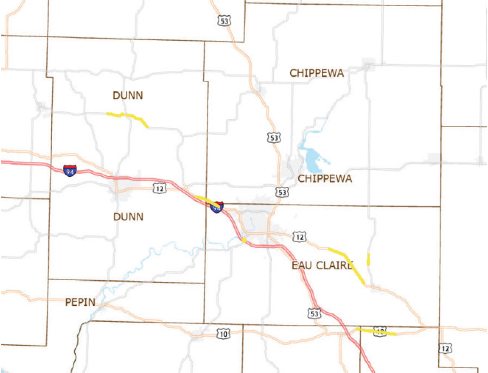
Wisconsin follows the Natural Resources administrative code: NR40 Invasive Species Identification, Classification and Control. Noxious and invasive plant species are generally controlled via countiesʼ mowing policies and herbicide application through a contractor. Selective or nonselective herbicides can be used and applied via county personnel or a properly licensed and certified external contractor. The HMM provides guidance about when, where, and how these herbicides can be used. Herbicides are the method of choice for noxious weed control, except in areas near remnant prairies where prescribed burning is WisDOTʼs preferred practice. Twenty-two high-quality remnant prairie sites have been identified along the right-of-way (Figure B-24).
Locations with varying growing conditions determine the recommended start of mowing operations. To mow noxious weeds before they go to seed and risk further spread, the HMM identifies one long-line mow 15 feet from the edge of the road to be completed for each county by a particular date (July 1st in Southern regions, July 15th in Central areas, and August 1st in Northern areas of the state) every year (Figure B-25). Every year, one-third of the right-of-way is mowed an additional 15 feet, where feasible, for woody vegetation control during the same
Long Description.
The map shows four entire counties of Wisconsin: Dunn, Pepin, Chippewa, and Eau Claire. The routes numbered 12, 53, 10, and 94 run along these counties. Yellow lines show where remnant prairies are located in Dunn and Eau Claire counties.
period. This 3-year rotational mowing is done to keep shrubs and trees out of the “clear zone.” The HMM provides additional guidance on mowing frequency, heights, widths, and other guidelines for highway areas (e.g., shoulders, medians, guardrails, and urban areas). Specific timing and frequency of mowing are required in High Potential Zone areas for the Karner blue butterfly, rusty patched bumble bee, and other federally listed species to provide optimal habitats for these sensitive or endangered species.
Counties remove hazardous trees beyond the clear zone (past the first 30 feet) on an as-needed basis under their routine maintenance agreements. Management outside of the routine requirements may require approval from BHM landscape architects.
That WisDOT must contract with counties to perform vegetation maintenance activities along state, interstate, and U.S. routes illustrates that WisDOTʼs structure is decentralized and is maintained differently from many transportation agencies across the country. Due to BHM staff being located mainly at the central office and only one staff member being present in each county, WisDOT enhances communication across the state through multiple brands of GIS and mapping software. WisDOTʼs systems also allow the BHM to showcase much of its information for the public to view. WisDOTʼs roadside vegetation asset management involves leaving much of the DOT-owned land in a natural state with no maintenance.
Software and Hardware
WisDOT uses software and hardware for vegetation management (Table B-8).
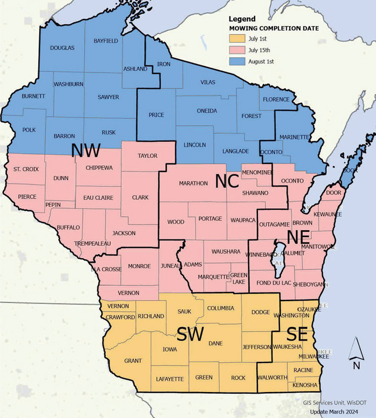
Long Description.
The state of Wisconsin is divided into five major regions Northwest, the North Central, the Northeast, the Southwest, and the Southeast. The legend of the map shows the Mowing completion date of July 1st, July 15th, and August 1st. Each date is represented by a color. The data given in the map are as follows. The counties in the blue section which include parts of the Northwest, North Central, and Northeast regions are to have mowing completed by August 1st. The counties in the pink section which include parts of the Northwest, North Central, Northeast, and Southwest regions are to have mowing completed by July 15th. The counties in the yellow section which includes parts of the Southwest region and all of the Southeast region are to have mowing completed by July 1st.
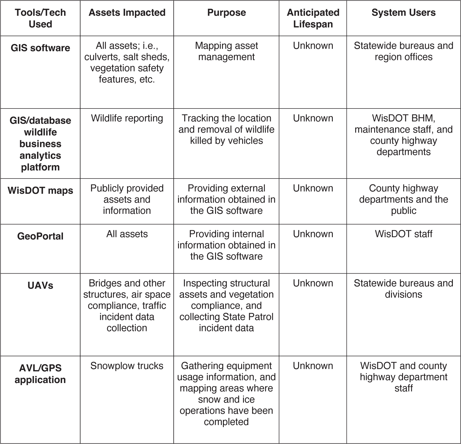
Long Description.
The column headers of the table are Tools or Tech Utilized, Assets Impacted, Purpose, Anticipated Lifespan, and System Users. The data given in the table row-wise are as follows: Row 1: GIS software: All assets; i.e., culverts, salt sheds, vegetation safety features, etc.; Mapping asset management; Unknown; Statewide bureaus and region offices. Row 2: GIS or database wildlife reporting software: Wildlife reporting; Tracking the location and removal of wildlife killed by vehicles; Unknown; WisDOT BHM, maintenance staff, and county highway departments. Row 3: WisDOT maps: Publicly provided assets and information; Providing external information obtained in the GIS software; Unknown; County highway departments and the general public. Row 4: GeoPortal: All assets; Providing internal information obtained in the GIS software; Unknown; WisDOT staff. Row 5: UAVs: Bridges and other structures, air space compliance, traffic incident data collection; Inspecting structural assets and vegetation compliance, and collecting State Patrol incident data; Unknown; Statewide bureaus and divisions. Row 6: AVL or GPS application: Snowplow trucks; Gathering equipment usage information, and mapping areas where snow and ice operations have been completed; Unknown; WisDOT and county highway department staff.
Mapping software: WisDOT uses three mapping software components sourced from commercially available and open-source products. The first software product focuses on GIS components and uses shapefiles. WisDOT employees create the data layers and collect the information. The second mapping software product uses KMZ files for mapping roadside vegetation asset management-related features. As with the GIS program, WisDOT employees create the data layers and collect the information. The third commercially available mapping software focuses more on database management and provides additional support in the form of data collection and the creation of mapping layers that WisDOT staff can access and use.
For internal staff, WisDOT maintains an interactive interface of ArcGIS Online that contains shapefiles of remnant prairie areas, endangered species distributions, mowing areas, and expectations (e.g., frequency and completion dates), as well as shapefiles of items related to the management of other transportation assets (Figure B-26). A few of the ArcGIS Online maps/layers are included in the WisDOT open data collection and are accessible by the public.
UAVs and LiDAR: WisDOT is in the early stages of incorporating UAVs for transportation and roadside vegetation asset management. The Bureau of Structures is exploring the use of UAVs for structure inspections and to identify cracking on bridges. The Bureau of Aeronautics uses UAVs to analyze vegetation violating air space clearance requirements, and the State Patrol uses UAVs for incident documentation. Trained UAV pilots in each bureau are required
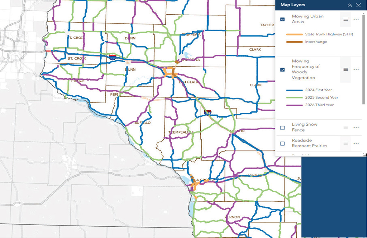
Long Description.
The map shows the southern and central regions of Wisconsin with several color-coded routes drawn on it. The counties mentioned in the map are St. Croix, Dunn, Pepin, Buffalo, Chippewa, Eau Claire, Trempealeau, Taylor, Clark, La Crosse, Jackson, Monroe, and Vernon. The right side of the map shows a text box titled Map Layers. The data given in the text box are as follows: Mowing urban areas (Selected): State Trunk Highway (STH) in orange lines and Interchange in brown lines. Mowing Frequency of Woody Vegetation (Selected): 2024 First Year in blue lines, 2025 Second Year in green lines, and 2026 Third Year in purple lines. The options of Living Snow Fence and Roadside Remnant Prairies are not selected.
to purchase and use their own equipment. WisDOT has a UAV policy and training program in place. Light Detection and Ranging (LiDAR) is being considered as an option to collect data or inventory assets to improve safety, aid in meeting federal requirements, and approach current practices more cost-effectively.
AVL/GPS: WisDOT uses an AVL/GPS to track snowplowing trucks via an application available on phones and tablets.
FAMS: The Facilities Asset Management System (FAMS) is an asset management system for roadside facilities. This system tracks all defined assets and their assessments and all maintenance activities specific to roadside facilities.
Implementation
WisDOT roadside vegetation asset management uses a GIS program to identify asset locations (but not to assess them), including vegetation safety features (e.g., living snow fences and screening), remnant prairies, demonstration prairie gardens inside rest areas, larger native seed installation and restoration locations, and documented areas of “prohibited” invasive plant species per the Wisconsin NR40 rule. WisDOT has also begun mapping locations of expected maintenance actions outlined by policy. These include long-line mowing, woody vegetation mowing, and
areas identified for conservation by the Monarch CCAA. WisDOT is making progress toward integrating the roadside vegetation asset management activities into planning and everyday operations with mapping software products. The counties and regions have semiannual patrol superintendent meetings to allow for education and communication regarding the work they are asked to do.
Problems with Implementation
WisDOT has faced challenges in fully implementing roadside vegetation asset management and effectively managing vegetation areas according to a statewide roadside vegetation asset management plan. These challenges include a lack of staff resources, expertise, state control over implementation, monetary resources, support by the legislature and counties, and availability of data. WisDOT is addressing these issues by employing consultants and limited-term employees, improving employee education, and reexamining processes.
Upcoming Implementation and Tasks
WisDOT is working with the manufacturer of a commercially available mapping software to create a GPS application for the public to report vehicular crashes involving wildlife. This system should be fully operational by the end of 2025.
In the roadside vegetation asset management plan, LiDAR is being considered to identify locations of specific invasive plant species and desired vegetation, protective barriers and other roadside items, roadside hazards, and general roadside conditions. UAVs are being considered to streamline the permit process for the removal of vegetation by others on the WisDOT right-of-way and to assess remnant prairies.
A combination of in-person and online training is provided every year on various topics for different audiences. A landscape architect attends the spring county patrol superintendent meetings and provides training on vegetation-related topics to county and WisDOT maintenance staff. The landscape architect also holds training on best management practices to protect specific endangered species, such as the Karner blue butterfly, and on prohibited invasive plant species.
WisDOT prioritizes in-person training, which is viewed as more effective; however, online training is often a more affordable and logistically easier option.
Conclusions
Vegetation management requirements and recommendations are outlined in the HMM. WisDOT is integrating roadside vegetation asset management activities into the stateʼs TAMP and faces challenges (e.g., local staff availability in counties, funding constraints, lack of expertise, and limited control over implementation). WisDOTʼs current vegetation management activities are implemented by county highway staff or WisDOT contractors with specialized expertise. Counties can sometimes hire contractors for certain specialized activities, such as prescribed burning; otherwise, the work is completed by county highway staff.
WisDOT is committed to improving operations by implementing technology selectively. So far, WisDOT has incorporated mapping software to track endangered species, sensitive areas, and mowing areas, and this software is expected to be more widely used in the future. WisDOT is hoping to integrate other technologies in use in other bureaus, such as UAVs and LiDAR, into its vegetation management systems.
Abbreviations and acronyms used without definitions in TRB publications: |
|
A4A |
Airlines for America |
AAAE |
American Association of Airport Executives |
AASHO |
American Association of State Highway Officials |
AASHTO |
American Association of State Highway and Transportation Officials |
ACI–NA |
Airports Council International–North America |
ACRP |
Airport Cooperative Research Program |
ADA |
Americans with Disabilities Act |
APTA |
American Public Transportation Association |
ASCE |
American Society of Civil Engineers |
ASME |
American Society of Mechanical Engineers |
ASTM |
American Society for Testing and Materials |
ATA |
American Trucking Associations |
CTAA |
Community Transportation Association of America |
CTBSSP |
Commercial Truck and Bus Safety Synthesis Program |
DHS |
Department of Homeland Security |
DOE |
Department of Energy |
EPA |
Environmental Protection Agency |
FAA |
Federal Aviation Administration |
FAST |
Fixing Americaʼs Surface Transportation Act (2015) |
FHWA |
Federal Highway Administration |
FMCSA |
Federal Motor Carrier Safety Administration |
FRA |
Federal Railroad Administration |
FTA |
Federal Transit Administration |
GHSA |
Governors Highway Safety Association |
HMCRP |
Hazardous Materials Cooperative Research Program |
IEEE |
Institute of Electrical and Electronics Engineers |
ISTEA |
Intermodal Surface Transportation Efficiency Act of 1991 |
ITE |
Institute of Transportation Engineers |
MAP-21 |
Moving Ahead for Progress in the 21st Century Act (2012) |
NASA |
National Aeronautics and Space Administration |
NASAO |
National Association of State Aviation Officials |
NCFRP |
National Cooperative Freight Research Program |
NCHRP |
National Cooperative Highway Research Program |
NHTSA |
National Highway Traffic Safety Administration |
NTSB |
National Transportation Safety Board |
PHMSA |
Pipeline and Hazardous Materials Safety Administration |
RITA |
Research and Innovative Technology Administration |
SAE |
Society of Automotive Engineers |
SAFETEA-LU |
Safe, Accountable, Flexible, Efficient Transportation Equity Act: A Legacy for Users (2005) |
TCRP |
Transit Cooperative Research Program |
TEA-21 |
Transportation Equity Act for the 21st Century (1998) |
TRB |
Transportation Research Board |
TSA |
Transportation Security Administration |
U.S. DOT |
United States Department of Transportation |

Transportation Research Board
500 Fifth Street, NW
Washington, DC 20001