Future Directions for Southern Ocean and Antarctic Nearshore and Coastal Research (2024)
Chapter: 6 Essential Capabilities
6
Essential Capabilities
Sustained investment in the science drivers identified in Chapters 3, 4, and 5 will advance U.S. scientific, workforce development, and economic interests. These science drivers, which all have global implications and high societal impact, include more accurate projections of sea level rise, better constraints on future changes to heat and carbon budgets, and a better understanding of the magnitude and rates by which Southern Ocean and Antarctic ecosystem services are expected to change. Increased investments in infrastructure and research programs are required to answer these questions and maintain a robust research program commensurate with other Treaty nations. The study of remote areas around Antarctica—ice, land, and ocean—will require an icebreaking vessel, access to global and local remote sensing data, airborne access for sampling coastal areas and floating ice, and year-round bases with modern laboratories. Since the heterogeneity and geographic scope of Antarctic research stretches beyond any single national program, partnerships are necessary for logistical success, and the U.S. Antarctic Program (USAP) must be flexible and creative in its approach to project funding to maximize benefits and minimize costs.
This chapter summarizes the essential capabilities identified in previous chapters and their availability to U.S. researchers (Figure 6-1). These capabilities include those hosted on USAP platforms, including the preliminary design of the Antarctic Research Vessel (ARV); those that are enabled by emerging tools and technologies; and specific programmatic approaches and partnerships that will advance and accelerate research. The final section of this chapter identifies gaps between capabilities and those required by the research priorities in Chapters 3, 4, and 5, and identifies several recommendations that would allow the United States to address those gaps.
VESSEL CAPABILITIES
As described in Chapter 2, both current USAP vessels—the Nathaniel B. Palmer and the Lawrence M. Gould—are approaching or have exceeded their roughly 30-year design service. The science priorities outlined in Chapters 3, 4, and 5 justify the need for large investments in a new USAP icebreaker. Below, high-priority vessel capabilities needed by U.S. researchers are identified. Where it is not practical to include these capabilities on a new USAP vessel, potential opportunities to access these capabilities through partner organizations or commercial arrangements are discussed. However, most partner organization resources are committed many years in the future and have planning horizons that are not well aligned with current National Science Foundation (NSF) processes. Given that reality, direct U.S. investments in infrastructure are strongly preferred to a reliance on partnerships,
as these investments will provide U.S. researchers the opportunity to drive research forward without external constraints, maintain leadership positions in the international polar community, support a well-trained future U.S. workforce, and engage as equal decision-making partners in the design and implementation of future international field programs. These investments in U.S. capabilities will strengthen U.S. scientific, workforce development, and economic interests both nationally and abroad.
NSF may need to consider trade-offs between vessel capabilities. To assist NSF in this effort, the committee classified capabilities needed by the U.S. researchers on USAP or partner vessels as Critical or Important for each of the science drivers (Table 6-1). The justifications for these classifications are expanded in the sections below. Where appropriate, the text references back to the more comprehensive justifications provided in Chapters 3, 4, and 5.
Polar Class 3 Icebreaking Capabilities
A Polar Class 3 (PC3) icebreaker for access into winter ice cover and to coastal areas is Critical for studies on sea level rise, global heat and carbon budgets, and changing ecosystems (see Chapters 3, 4, 5; Table 6-1). Specifically, a PC3 icebreaker would enable improved understanding of nearshore and winter processes such as sea ice production, dense shelf water production, oceanic forcing of Antarctic ice shelves, water mass modification in polynyas, and ecosystem processes on sea ice and in coastal polynyas (Chapters 3, 4, 5; Table 6-1). This access to the coast across all seasons is also essential for deploying other capabilities such as ice stations (e.g., Ackley et al., 2020), and emerging autonomous platforms and drifting platforms capable of operation in ice-covered waters and within ice shelf cavities.
TABLE 6-1 Critical (C) and Important (I) capabilities for U.S. Antarctic Program (USAP) or Partner Vessels for the Three Science Drivers Identified in this Report
| Capabilities on USAP or Partner Vessels | Sea Level Rise | Global Heat and Carbon Budgets | Changing Ecosystems |
|---|---|---|---|
| Polar Class 3 icebreaking capabilities | C | C | C |
| Endurance: >70 days summer and >50 days winter icebreaking | I | C | I |
| Full helicopter support | C | I | I |
| Ability to launch and recover uncrewed aerial systems | I | C | C |
| Ability to launch and recover large uncrewed underwater vehicles | C | C | C |
| Moonpool | I | ||
| Zodiacs, rigid inflatable boats, and other small boats associated with an icebreaker | I | C | C |
| Hull-mounted sensors (e.g., shipboard sonar, scientific echosounder, and sub-bottom profiler) | C | C | C |
| Towed sampling and instrumentation (magnetic, multichannel seismic, underway profiling CTD packages, controlled-source electromagnetics, nets) | I | C | C |
| Seafloor and submarine sampling (e.g., coring, drilling, dredging, seafloor or borehole observatory) | C | C | C |
| Live organism experiments (aquarium facilities, incubators, running seawater) | C | ||
| Low-temperature storage | I | C | |
| >45 berths for science and support staff | I |
NOTES: The most crucial capabilities are Critical, with Important and blank cells indicating lesser importance. CTD = conductivity, temperature, and depth.
The ARV is currently designed as a PC3 vessel with the nominal capability to transit continuously through level ice over 1.3 m (4.5 ft) thick at more than 3 knots (Antarctic Support Contractor, 2023). The Nathaniel B. Palmer is approximately equal to a PC5 or PC4, with year-round operation limited to medium first-year ice. In practice, the Nathaniel B. Palmer icebreaking capabilities are limited, particularly in winter and in areas where there is extensive ridging, deep snow cover, and significant ice pressure. For example, historically, the Nathaniel B. Palmer has been limited to regions of the outer pack in midwinter in the Ross and Bellingshausen seas (e.g., Jeffries et al., 1998). In early autumn, ice pressure has limited travel even through thin ice (Ackley et al., 2020). Even in summer, access to some areas of critical concern (e.g., the western Bellingshausen Sea and the Amundsen Sea Embayment) is not always possible with the Nathaniel B. Palmer.
An analysis of icebreaking capability based on ice charts (Future USAP, 2023b) suggests a PC3 vessel would be able to access practically all areas around the Antarctic year-round, with the potential exceptions of areas where perennial ice is common. This analysis is likely optimistic, as ice charts do not account for ridging extent or amount of snow cover, so areas that are prone to particularly heavy ridging or deep snow may still present challenges in winter for a PC3 vessel. It seems likely that many coastal regions will remain challenging to access in winter, particularly the western Weddell, southern Bellingshausen, Amundsen, and eastern Ross seas, as well as parts of the East Antarctic coastline. However, winter access to the Antarctic coast will likely now be possible in the Ross Sea and eastern Weddell Sea, and critically, access to almost all areas will be feasible in summer (with the possible exception of limited areas of the western Weddell Sea). This is likely a reasonable trade-off, as a PC3 will offer better access than the current capability of the Nathaniel B. Palmer (PC5/PC4), while the added operational expense and design constraints of a PC1 or PC2 vessel are difficult to justify solely for access to those few regions that may be challenging outside of the summer season. In those rare circumstances where access through extreme ice conditions is required, it would be more economical to partner with one of the Coast Guard’s Polar Security Cutters or another nation’s heavy icebreaker.
Some observations of ice and ocean processes in difficult-to-access regions during winter are possible via alternative platforms, including in situ autonomous observations and a variety of moored platforms and drifting platforms and floats (including ice-tethered platforms and biogeochemical Argo [BGC-Argo] floats). However, these approaches currently require vessel support for deployment and recovery, and few are well suited for deployment in coastal regions. Long-range autonomous underwater vehicles and gliders capable of operating under ice for extended periods are emerging technologies (e.g., Barker et al., 2020; Lee et al., 2022), although long endurance and range capabilities come at the expense of more limited sensor payload. For the foreseeable future, the only means of access to remote, ice-covered areas will require icebreaker support. In some cases—for example, deploying observational arrays in heavy ice or various platforms near the front of ice shelves—helicopter support could mitigate access restrictions for a vessel with reduced icebreaking capabilities.
The icebreaking capability of the preliminary design of the ARV would be comparable to the Norwegian Kronprins Haakon, Australian Nuyina, and the Chinese Xue Long 2. The German Polar Stern II and a future Swedish icebreaker are also anticipated to have similar icebreaking capabilities. While several international partners have or are anticipated to have similar icebreaking capability to the ARV, those that typically operate in the Pacific sector of the Southern Ocean (Korea, Italy, and the United Kingdom), where the USAP most commonly operates, currently have PC5 capability at most. A PC3 vessel would offer opportunities for joint operation with, for example, South Korea’s Araon and Great Britain’s Sir David Attenborough, leveraging the former’s icebreaking capabilities with the Araon and Sir David Attenborough’s helicopter support capabilities. See Appendix B for the capabilities of these and other ships.
Endurance
Greater endurance is required for periods of extensive icebreaking capability. Thus, greater than 70 days of endurance in the summer and >50 days of endurance during winter icebreaking is classified as Critical for global heat and carbon budgets studies and Important for sea level rise and changing ecosystem studies (Table 6-1). For example, the ability to study Antarctic Bottom Water formation processes in the winter (Chapter 4) would require extensive icebreaking, which would likely require this level of endurance. Longer endurance is also necessary for
USAP access to East Antarctica (Box 6-1). Greater than 70 days endurance in the summer would allow access, for example, to the Totten Glacier in East Antarctica (Chapter 3), as its remoteness would entail significant transit (roughly 8–10 days one way from Hobart, Australia) and still accommodate a 50-day science cruise on site.
Following several prior community reports that called for greater than 80 days of endurance (Chapter 2), the endurance of the ARV is designed for midsummer optimal maximum of 90 days. This means that the ARV may be able to operate for 45–60 days for a midwinter cruise that requires significant icebreaking through areas of extensive ridging, thick snow cover, and greater ice pressure.1
Helicopter Support
The ability for U.S. researchers to have access to two light-duty helicopters on USAP or partner vessels is Critical for access to near-shore areas for studies on sea level rise (Chapter 3; Table 6-1). Identifying and characterizing complex processes driving solid Earth–ice–ocean–atmosphere interactions requires tactical deployment of surface instrumentation, drilling equipment, and associated field camps in coastal areas. Many of the most compelling places to acquire data relevant to sea level rise research—such as fast-flowing glaciers, grounding zones, and ice shelves—are too dangerous or too remote to be accessed by fixed-wing aircraft such as Twin Otters (Figure 6-2). For example, the most rapidly retreating (and arguably the most important to study) section of Thwaites Glacier’s grounding line is heavily crevassed and impossible to land on using fixed-wing aircraft. As a result, the International Thwaites Glacier Collaboration (ITGC) has so far been limited to deploying surface camps on Thwaites’s less dynamic Eastern Ice Shelf, where an airplane could operate safely.2 If ITGC had access to helicopters, it is possible that their hot water drilling efforts, for example, could have enabled robotic exploration of the most rapidly melting part of the Thwaites Glacier Tongue.
Access to USAP or partner vessels with helicopter support is also classified as Important for studies on global heat and carbon budgets and changing ecosystems (Chapters 4, 5; Table 6-1). Deployment of ice-tethered platforms via vessels with helicopter support is a common operation in the Arctic and has also been employed by several Antarctic programs (e.g., Krishfield et al., 2008). Helicopters have also enabled remote surveys of sea ice properties (e.g., Heil et al., 2009). Helicopters further support efficient deployment of buoy arrays and enable sampling on ice floes while freeing up the vessel to conduct other observations. For a complex buoy array, use of a helicopter can save many days of ship time and open access to some otherwise inaccessible areas of heavy ice. Additionally, vessels with helicopter support can aid in reconnaissance and possible access missions (e.g., facilitating heavy-lift operations for access drilling) for the exploration of ecosystems along grounding zones and coastal margins.
A vessel with full helicopter support (including a helideck and hangar to store and service two helicopters) was supported by previous community workshops and reports (ARVOC, 2006; NSF OPP Advisory Committee, 2019; UNOLS, 2011, 2012). Full helicopter support was eliminated from the Conceptual Design of the ARV in 2020 (Glosten, 2021). Key decision drivers for the removal of the helideck were the cost of construction and maintenance; the space required to accommodate the helideck, hanger, and supporting infrastructure; and concerns over the historical cost of supporting helicopter operations on the Nathaniel B. Palmer. Indeed, NSF has noted that the helideck on the Nathaniel B. Palmer has only been used three times in 30 years, although data on the number of projects that initially proposed helicopter work that were rejected or asked to descope the helicopter work due to costs were not available.3 NSF reports that full helicopter support could drive the ARV to be larger, increasing its displacement and operational costs4; however, the committee has not seen a documented technical analysis of the trade-offs. While the exact impacts are uncertain, increasing the size of the ARV could impact seakeeping, speed and fuel efficiency, and icebreaking, among other parameters.5 The current preliminary design of the ARV can host the landing and takeoff of a single helicopter—for example to transport scientists from the ARV to a partner vessel that supports helicopters or to enable transport with land-based helicopters. However,
___________________
1 Presentation to the committee by NSF, March 2023.
2 Presentation to the committee by Keith Nicholls, British Antarctic Survey, March 2023.
3 Presentation to the committee by NSF, March 2023.
4 Presentation to the committee by NSF, May 2023.
5 Presentation to the committee by NSF, March 2023.

NOTES: Locations of the grounding zone (dashed lines) and subglacial lakes (small contours) are also shown in (b)–(d). Geophysical observational networks deployed by fixed-wing aircraft or on-land traverses, including seismic and GNSS stations, are plotted. The range of fixed-wing-accessible areas assumes a 700 km range of Twin Otters, without refueling on the way, and are based on one of the sites: McMurdo, South Pole, Siple Dome, West Antarctic Ice Sheet divide, and Palmer. Plots of the Byrd subglacial basin and Thwaites glacier area, Wilkes Subglacial Basin area, and Aurora Subglacial Basin areas are also highlighted. ES-PERMANENT = permanent stations with data accessible from the EarthScope Consortium; GAMSEIS = Gamburtsev Antarctic Mountains Seismic Experiment; GNSS = Global Navigation Satellite System; POLENET = Polar Earth Observing Network; TAMSEIS = Transantarctic Mountains Seismic Experiment; UK-ANET = U.K. Antarctic Network; RIS = Seismic Experiment on the Ross Ice Shelf.
SOURCE: Weisen Shen.
it does not provide full support for onboard helicopters without a partner vessel or base (ARV SASC, 2023). It should be stressed that, while access to USAP or partner vessels that support helicopters was judged as Critical for the sea level rise science driver, a potential lack of dedicated helicopter support on the ARV in no way invalidates the critical and important needs for a vessel with icebreaking and science capabilities as outlined in this report. Chapters 3–5 outline national science priorities that fully justify the needs for new science icebreaking capacity in their own right.
U.S. helicopter lease costs on cruises are currently sourced from the Antarctic sciences budget,6 rather than from the logistics budget, which is the practice in many other nations that provided input for this report. NSF estimates that the cost of supporting helicopter operations is approximately $2–3 million per deployment.7 Mobilization and demobilization costs (i.e., transporting the helicopters to and from the port[s] of departure and arrival) and the day rate for long expeditions (even if helicopters are only used part of the time) are the most significant cost drivers, along with jet fuel and extra safety gear.8 In contrast to NSF’s estimate, the committee found that the cost for a Canadian firm to operate two AS-350 helicopters on a 50-day cruise from Lyttelton, New Zealand, with the Korea Polar Research Institute (KOPRI) is currently close to USD 330,0009; but comparison of full-cost accounting budgets under various international funding models is beyond the scope of the committee’s task. Further exploration of cost-effective solutions and potential collaborations for helicopter-supported field work would benefit the science drivers in the report.
While helicopters can save many days of ship time and facilitate access to some difficult-to-access locations, this advantage can be partially offset by a vessel with PC3 icebreaking capabilities for sea ice and ocean studies. The ability to deploy small drifting platforms or expendable ocean profilers via uncrewed aerial systems (UASs) is an emergent capability that warrants investment in engineering. However, for most sensor modalities in or under ice this is not currently feasible, and it may never be practical for some high-value observations requiring complex logistics, such as ice-tethered profiler deployments on fast ice adjacent to ice shelves.
The use of heavy-lift UASs to support ice-based research (e.g., large-scale remote sensing surveys) may also be possible in the future, offering an alternative to crewed helicopters for some applications. This capability is currently best achieved with large, heavy-lift (gas-powered) UASs that can travel well beyond direct line-of-sight piloting. The primary limitation for this capability is regulatory. Enabling this capability on USAP vessels would be important in the absence of helicopter support. There are also several commercial companies developing autonomous aerial vehicles (AAVs) or electric vertical takeoff and landing (eVTOL) vehicles with passenger capabilities. Systems under development range from fully autonomous to piloted. Claimed capabilities include ranges of more than 100 km and capacities for up to four passengers (e.g., Joby Aviation). Significant challenges remain for operation in the Antarctic, including required long-ranges, remoteness, landing on uncertain terrain, and regulatory requirements. It is unclear whether future systems that meet the unique challenges of Antarctic operation could also be significantly smaller or cheaper, or have smaller support-personnel requirements than crewed light-duty helicopters. Additionally, it is unclear if they could be supported on the current design of the ARV. For example, current eVOTL aircraft designs (e.g., Joby Aviation, CityAirbus) are comparable in size to traditional light-duty helicopters with limited range. Smaller, unpiloted aircraft (e.g., Ehang) have very limited range. Greater range is possible with fueled AAVs. While it is difficult to predict what AAV capabilities may be possible in a decade or two, significant developments in battery technology (i.e., much greater ranges) and autonomy are needed before operation in remote areas is possible with platforms that are competitive in size, logistics, safety, and range with current traditional helicopters.
Another possible alternative to ship-based helicopter support could be land-based combined fixed-wing and helicopter operations (the latter being necessary in those cases such as heavily crevassed ice shelves where fixed-wing landing is unfeasible). This type of operation has previously been supported by the USAP. For example, in 2012–2013, an expedition to Pine Island Glacier, adjacent to the Thwaites Glacier, involved the establishment
___________________
6 Presentation to the committee by NSF, February 2023.
7 Presentation to the committee by NSF, May 2023.
8 Presentation to the committee by NSF, May 2023.
9 Presentation to the committee by Won Sang Lee, KOPRI, March 2023.
of a camp that included helicopter support. Helicopters were transported by ski-equipped LC-130s operated through McMurdo Station.10 Some of these operations have proved challenging in the past in regions that have poor weather and that are remote from bases. These challenges have led to significant impacts to science projects, with some teams with complex operations reporting month-long delays in departing McMurdo for remote camps (Hansen, 2009; Stewart, 2013).
Helicopter support on icebreakers has been prioritized by many international partners (Appendix B). For example, KOPRI’s Araon was initially designed to carry a single, heavy-lift Kamov Ka-32A, but has since adapted to carry either two light-utility AS-350 or Bell 206 helicopters. The Araon operates with a small hangar, thanks to the use of an extendable structure used to protect the aircraft during transit or in inclement weather (Figure 6-3). KOPRI relies on helicopter support on nearly all of their marine voyages; this regular usage has helped them develop practical strategies for efficient use of aircraft and balancing priorities on interdisciplinary expeditions. For example, KOPRI has used their helicopter capacity to tag Weddell seals on all sides of Thwaites Glacier, deploy surface-based GPS and weather stations, collect rock samples from nearby outcrops, install static radar sounders to measure basal melt rates, conduct airborne geophysical surveys, and acquire full-depth ocean profiles between icebergs within 10 km of Thwaites’s grounding line using expendable ocean sensors. KOPRI conducted this level of work in early 2022 during a season in which the icebreaker Araon was unable to gain access within 130 km of Thwaites Glacier.
Other partners that commonly use helicopters on vessel deployments include Australia, China, France, Germany, Japan, South Korea, Sweden, the International Association of Antarctica Tour Operators (IAATO), and the U.S. Coast Guard. The Swedish icebreaker Oden commonly uses helicopters but does not routinely operate in Antarctica. The United Kingdom is a common USAP partner and its new vessel, the Sir David Attenborough, is designed to support helicopters (see Appendix B). These partners offer opportunities for collaboration (see section on Collaboration and Partnerships), with partner nations taking advantage of the PC3 icebreaking capability of the ARV and the USAP taking advantage of partners’ helicopter support. However, there are also some potential disadvantages of relying exclusively on international partnerships for helicopter support. These include the added difficulty of facilitating and managing partnerships between scientists and the logistical organizations supporting the intended work, including the necessity to align science priorities between the national programs. The added cost of operating two ships for a single project is another disadvantage of relying on a two-ship model with international partnerships. Building and maintaining international partnerships through individual foreign collaborations can lead to inconsistency across programs and require that the principal investigator (PI) invest substantial time and remain much more flexible than when working solely through the USAP. So-called lead agency agreements11 can facilitate international partnerships by allowing investigators represented by two national programs to submit linked proposals that, if funded, provide clear expectations and points of contact between the two programs. NSF’s Directorate for Geosciences has so far only established lead agency agreements with Germany, Ireland/Northern Ireland, Israel, Switzerland, Taiwan, and the United Kingdom (NSF, n.d.k); more are needed if international partnerships are expected to substitute for a lack of helicopter support on the ARV.
There may be creative solutions to addressing the design challenge that may stop short of the full helicopter support model chosen by other programs for recent ship designs (e.g., Australia, France, China, Norway, United Kingdom) but that could still enable two light-duty helicopters to operate on the ARV. While the committee cannot comment on the engineering design feasibility of these creative solutions, it is possible that discussions with partners about their vessel design may yield ideas that could be incorporated without delaying progression of the ARV through the Final Design Stage. For example, NSF could consider an approach in which the ARV helideck supports two light-duty helicopters without providing a hangar, analogous to the operation of the Swedish icebreaker Oden. Helicopters on the Oden utilize the sides of the helideck for takeoff, landing, and parking (Figure 6-4), which provides sufficient separation for safe operation of the second aircraft. The footprint of the Oden helideck would
___________________
10 Written response from NSF to the committee, April 2023.
11 Lead agency agreements “provide a framework for joint peer review of proposals by two funding agencies in different countries. One organization takes the lead in managing the review process with an agreed level of participation by the other, and both agencies accept the outcome of the review process and fund the costs of the successful applications in their respective countries” (UKRI, 2022, para. 3).
SOURCE: Won Sang Lee.

SOURCE: Alan Mix.
fit approximately within the space provided on the present design of the ARV aviation deck; however, the committee does not have the expertise to comment on the feasibility of adjustments to the side railings and Foremast Instrument Platform to enable safe approaches. Helicopter hangars are used primarily to protect aircraft from sea spray on transits to and from Antarctica or during stormy weather, and to provide a heated space for maintaining the aircraft. The rearward placement of the Oden’s helideck may partially mitigate the impact of sea spray on
transits and in stormy weather, a feature that the ARV would lack with the planned helideck placement on the bow; note, however, that the planned height of the ARV’s helideck is 16 feet higher than the level of the Oden’s helideck (51 ft vs. 35 ft). The committee is not appropriately constituted to comment on the engineering design of the ARV, but engagement with potential helicopter operators and others may assist in evaluating what is feasible.
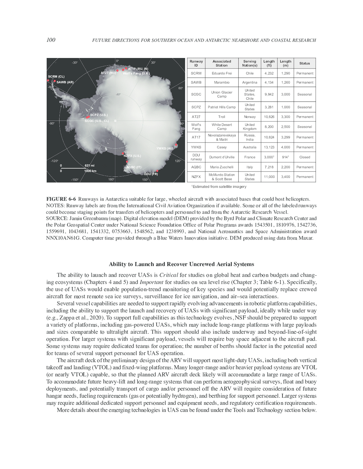
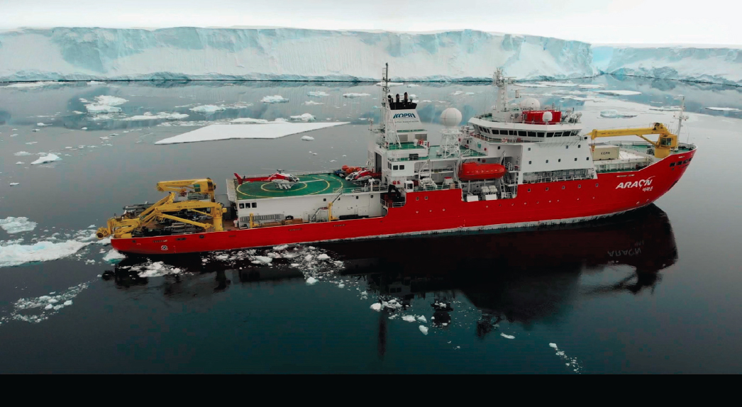
It may be possible for USAP to consider a helideck-only approach thanks to its management of robust intercontinental aviation contracts. The USAP could leverage this unique position to reposition helicopters and their pilots and support staff to and from Antarctica to meet the ARV when needed, thus minimizing marine transits across the Southern Ocean with aircraft exposed to sea spray. The KOPRI represents an existing precedent for this operation. To guarantee uninterrupted helicopter support, KOPRI routinely uses C-130 aircraft to reposition two AS-350 helicopters between Christchurch and Jang Bogo Station in Terra Nova Bay (Figure 6-5). While McMurdo is a natural hub for this type of operation, nine other runways could currently support large, wheeled aircraft such as C-130s and C-17s, which both can carry two helicopters; a tenth optional runway could become available if the French Polar Institute refurbished its Piste du Lion runway facility near Dumont d’Urville Station (Figure 6-6). International agreements for runway access could be particularly compelling, considering the ARV’s long endurance; it is conceivable that within a 90-day cruise window, the ARV could conduct voyages with and without helicopter support if passengers and helicopters could be transported to and from the ARV from one of the participating runways.

NOTE: The Korean Polar Research Institute routinely uses wheeled C-130 aircraft to ferry light-duty AS-350 helicopters to and from Antarctica.
SOURCE: Louis Magnan, Canadian Helicopters Limited.
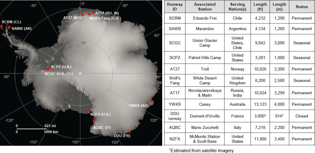
NOTES: Runway labels are from the International Civil Aviation Organization if available. Some or all of the labeled runways could become staging points for transfers of helicopters and personnel to and from the Antarctic Research Vessel.
SOURCE: Jamin Greenbaum (map). Digital elevation model (DEM) provided by the Byrd Polar and Climate Research Center and the Polar Geospatial Center under National Science Foundation Office of Polar Programs awards 1543501, 1810976, 1542736, 1559691, 1043681, 1541332, 0753663, 1548562, and 1238993, and National Aeronautics and Space Administration award NNX10AN61G. Computer time provided through a Blue Waters Innovation initiative. DEM produced using data from Maxar.
Ability to Launch and Recover Uncrewed Aerial Systems
The ability to launch and recover UASs is Critical for studies on global heat and carbon budgets and changing ecosystems (Chapters 4 and 5) and Important for studies on sea level rise (Chapter 3; Table 6-1). Specifically, the use of UASs would enable population-trend monitoring of key species and would potentially replace crewed aircraft for most remote sea ice surveys, surveillance for ice navigation, and air–sea interactions.
Several vessel capabilities are needed to support rapidly evolving advancements in robotic platform capabilities, including the ability to support the launch and recovery of UASs with significant payload, ideally while under way (e.g., Zappa et al., 2020). To support full capabilities as this technology evolves, NSF should be prepared to support a variety of platforms, including gas-powered UASs, which may include long-range platforms with large payloads and sizes comparable to ultralight aircraft. This support should also include underway and beyond-line-of-sight operation. For larger systems with significant payload, vessels will require bay space adjacent to the aircraft pad. Some systems may require dedicated teams for operation; the number of berths should factor in the potential need for teams of several support personnel for UAS operation.
The aircraft deck of the preliminary design of the ARV will support most light-duty UASs, including both vertical takeoff and landing (VTOL) and fixed-wing platforms. Many longer-range and/or heavier payload systems are VTOL (or nearly VTOL) capable, so that the planned ARV aircraft deck likely will accommodate a large range of UASs. To accommodate future heavy-lift and long-range systems that can perform aerogeophysical surveys, float and buoy deployments, and potentially transport of cargo and/or personnel off the ARV will require consideration of future hangar needs, fueling requirements (gas or potentially hydrogen), and berthing for support personnel. Larger systems may require additional dedicated support personnel and equipment needs, and regulatory certification requirements.
More details about the emerging technologies in UAS can be found under the Tools and Technology section below.
Ability to Launch and Recover Large Uncrewed Underwater Vehicles
The ability to readily launch and recover large uncrewed underwater vehicles (UUVs, including autonomous underwater vehicles [AUVs], remotely operated vehicles [ROVs], and gliders), autonomous surface vehicles (ASVs), and other underwater/under-ice sensing platforms is Critical for studies on sea level rise, global heat and carbon budgets, and changing ecosystems (Chapters 3, 4, 5; Table 6-1). For large AUV operations, such as the UK National Oceanography Center’s Autosub, significant deck space for dedicated launch and recovery system (LARS) vans is often needed. Many large ROVs also require complex deck operations. Some vehicles have dedicated systems for deployment, while other smaller platforms require aft and/or over-the-side craning capabilities for deployment and recovery. Easy deployment capability for acoustic navigational aids will also benefit AUV operation, including the ability to access a hull instrument well to install an acoustic communication system, to make use of existing well-mounted transducers for such purposes, or to include a dedicated system.
Gliders and many AUVs require accurate buoyancy trimming prior to deployment, which can be done most efficiently off vessels with low freeboard. For most small AUVs (e.g., gliders, REMUS [Remote Environmental Monitoring Units]), deployment and recovery operations using zodiacs, workboats, or rigid inflatable boats increases ease of recovery and reduces risk of damage to the vehicle and its sensors. Zodiacs, workboats, or rigid inflatable boats can also aid in recovery in small open-water areas in ice-covered regions. Alternatively, most medium-sized AUVs and ROVs can be deployed over the side, provided the ship is capable of maintaining open water to the side or aft of the ship. The effectiveness of this approach depends on the capability of the vessel thrusters to provide azimuthal control and flexible thrust to effectively clear ice. Deploying ROVs in loose ice conditions can be challenging because of the need to protect the tether from moving ice. An investigation of whether a dedicated launch-and-recovery system for a variety of small- to medium-sized AUVs and ROVs over the side, or to the aft of the vessel, could be incorporated into the ARV design would be useful. These systems ease operations and mitigate risk of damage to the vehicles. For example, such systems have been used to aid the launch of ROVs through moonpools.
Moonpool
A moonpool is not viewed as essential for most autonomous vehicle operations. As such, access to a moonpool is deemed as Important but not Critical on USAP or partner vessels for studies on global heat and carbon budgets (Chapter 4). A moonpool can offer operational advantages versus over-the-side operation for small- to medium-sized ROVs, including the ability to deploy and recover in all conditions. This generally requires specialized systems for deployment and tether management. Several partner vessels, including the Sir David Attenborough (BAS, 2020) and the Nuyina (Australian Antarctic Division, 2022), have included moonpools with systems for deployment of a variety of equipment in rough conditions and in ice. In some cases, other approaches can be employed for over-the-side UUV deployment, such as armored or protected tethers, and an open-water area can often be maintained to the side of the vessel in continuous, stable ice conditions. However, in more dynamic ice conditions and for some ROV systems, over-the-side operation can be difficult to impossible. A moonpool might also aid in some small AUV deployments, but at present, recovery is generally easier through openings in the ice, potentially aided by zodiacs or rigid inflatable boats. A moonpool can also facilitate acoustic navigation and communication aid deployment in a wide variety of ice conditions.
A second potential use for a moonpool is for CTD deployment. Although this is not a common operation on icebreakers, several partner vessels have been designed to accommodate this. For example, the Nuyina has a moonpool positioned such that the ship CTD can be deployed either over the side or through the moonpool (Australian Antarctic Division, 2023c). To be able to address the science drivers in this report, vessels need to be able to conduct 8-hour CTD operations in ice and rough seas. CTD deployment over the side, even from a dedicated baltic room,12 can be challenging in moving ice conditions or difficult weather. Moving ice conditions can be managed with some effort using the vessel thrusters, while difficult weather can be severely limiting in
___________________
12 A baltic room is a garage for equipment that leads out onto the back deck.
certain wind and wave conditions, such as in the marginal ice zone or in coastal polynyas in winter. A moonpool could allow CTD operations in practically all conditions but would require significant space to accommodate.
Inclusion of an interior midship moonpool on the ARV would come at the expense of laboratory space and/or berthing,13 and although considered potentially useful, did not receive widespread support at the February 2023 Community Workshop. Additionally, it is uncertain whether a moonpool of sufficient size on the aft deck could be accommodated (as has been retrofitted on the Nathaniel B. Palmer for drilling), as it may interfere with the positioning of the propulsion system.14 Concerns about deployment of CTD and UUV in difficult conditions without a moonpool appear to be mitigated in the current ARV design, which includes podded thrusters for better seakeeping, improved ability (relative to the Nathaniel B. Palmer) to maneuver in ice, better load handling on the CTD winch (including articulating arms for deployment), and active heave compensation. These capabilities suggest over-the-side operations will be possible in higher winds, sea state, and more challenging ice conditions than is currently possible on the Nathaniel B. Palmer15 (NSF, 2023d).
Several potential partners’ ships include a moonpool, including the Sir David Attenborough, the Agulhas II, the Nuyina, the Polarstern II (under construction), and a planned future Swedish icebreaker. However, partnerships could only reasonably compensate for the lack of a moonpool on USAP vessels in rare cases, like well-coordinated joint operations. The Nathaniel B. Palmer does have a small moonpool, but since it is accessed on the aft deck (making use difficult for significant operations since it takes potential van space) and is known to get clogged with ice, it has seen limited use. As other nations’ vessels are new or not yet built, it remains unproven how well their moonpools operate under various conditions—particularly in ice.
Zodiacs, Rigid Inflatable Boats, and Other Small Boats Associated with an Icebreaker
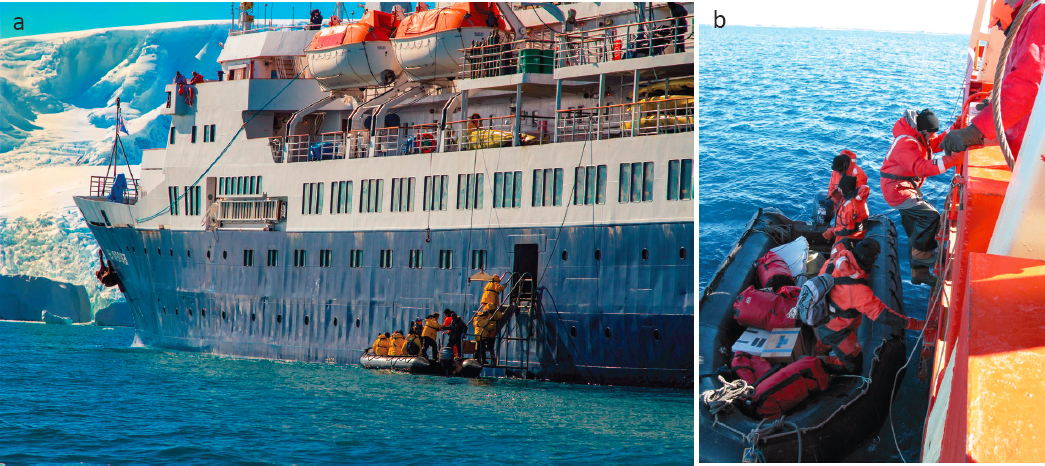
Rigid inflatable boats, zodiacs, and other small boats associated with larger vessels are Critical for studies on global heat and carbon budgets and changing ecosystems (Chapters 4, 5) and Important for studies on sea level rise (Chapter 3; Table 6-1). These small boats are often essential to the deployment and recovery of small AUVs. Access to small boats on the Nathaniel B. Palmer and Laurence M. Gould often requires descending a ladder over the side of the research vessel, which significantly limits the conditions in which small boat operations can be conducted. For example, the design of the Laurence M. Gould makes it difficult to get small boats and equipment safely off the side of the vessel, requiring a rope ladder climb that can be difficult in icy conditions, as well as a well-timed transition from the ladder to the inflatable that can be hazardous in choppy seas (Figure 6-7). Moreover, craning pallets over the side of the Laurence M. Gould into inflatable boats is challenging because of the lack of direct visibility between the crane operator and the boat being loaded with supplies. An improved system for craning equipment into inflatable boats is needed to support the science drivers outlined in this report.
The conceptual design of the ARV includes four high-quality small boats, including a large landing craft and multibeam survey boat (Glosten, 2021). The design currently allows for launching small boats and inflatable craft while at sea. The ability for some of these small boats to be launched in rough seas and to get through thicker, brash ice to land equipment and personnel on Antarctic shores is needed in order to support the science drivers. The ARV will need to be capable of launching and recovering small boats rapidly and safely to take advantage of small windows of good weather, particularly as the need for winter data increases alongside the attendant challenges of operating in difficult weather conditions.
Hull-Mounted Sensors
Hull-mounted sensors (e.g., shipboard sonar and sub-bottom profiler) are Critical for studies on sea level rise, global heat and carbon budgets, and changing ecosystems (Chapters 3–5; Table 6-1). Specifically, these sensors
___________________
13 Presentation to the committee by NSF, May 2023.
14 Presentation to the committee by NSF, May 2023.
15 Presentation to the committee by NSF, May 2023.
SOURCE: (a) Stephen March/Alamy Stock; (b) Burmeister, 2003.
would assist in improving mesopelagic biomass estimates (Chapter 5) and bathymetry, geology, and water mass structures of coastal and deep-sea regions around Antarctica (Chapters 3 and 4).
Acoustic waves are the most effective form of energy propagation in the ocean. Lower-frequency acoustic waves (below about 20 Hz) can propagate thousands of kilometers before their energy is absorbed by the water. The energy of higher-frequency acoustic waves (above 10 or 100 kHz) can attenuate faster, but their short wavelength enables high-resolution observations of ocean environments. These waves can also reflect from interfaces or be scattered by objects and rough surfaces in the water. With advanced signal-processing techniques, the reflected or scattered acoustic wave can be analyzed to image the underwater world. Broadband bioacoustics sonar systems (Lavery et al., 2007; Loranger et al., 2022) are critical instruments for imaging and estimating mesopelagic biomass, and Acoustic Doppler Current Profilers (ADCPs) are necessary for measuring ocean currents in different depths of water (Meijers and Klockers, 2010; Wilson et al., 1997). Wide-angle multibeam echosonar systems (Dorschel et al., 2022; NOAA, n.d.a) and sub-bottom acoustic profilers (Larter et al., 2021) are the most efficient and effective tools for mapping the seafloor and the shallow sub-bottom layering structure (Gales et al., 2014). These mapping tools are especially critical for conducting Antarctic coastal and glacial research in uncharted areas. In addition to seafloor survey, multibeam echosounders also have midwater imaging capabilities and backscattering strength measurements, enabling many other critical observations, including mapping of submerged iceberg or ice shelf fronts/faces, identification and characterization of different habitats for benthic ecosystems, localization and characterization of seeps or hydrothermal systems, and their associated midwater plumes. Besides environmental study, another important application of underwater acoustics is communication and navigation (Freitag et al., 2015; Paull et al., 2014), which is critical for operating UUVs, navigating moorings and profilers, and communicating with underwater instruments and operators.
The preliminary design of the ARV includes a number of science underway sensors, including deep- and shallow-water multibeam mapping, ADCPs from 38–300 kHz, sub-bottom profilers (3.5 kHz, chirp or parametric narrow-beam profiler), marine biology echosounder/sonars from 18 to 200 kHz, an ultrashort baseline transceiver, an acoustic release transponder (12 kHz), hydrophones, and a forward-looking camera and sonar (Antarctic Support Contractor, 2023). It is worth noting that recent development on acoustic and echosounder technology has enabled narrower beams, wider bandwidth, and larger swath coverages for high-resolution surveys and mapping. It is
Critical to include state-of-the-art echosounders to enable the best-possible environmental sensing and underwater communication capabilities.
Towed Sampling and Over-the-Side Instrumentation
Towed sampling and instrumentation (e.g., underway profiling CTD packages, nets for trawling, multichannel streamers and airgun arrays, controlled-source electromagnetics, towed magnetometers) are Critical for studies on global heat and carbon budgets and changing ecosystems (Chapters 4 and 5) and Important for studies on sea level rise (Chapter 3; Table 6-1).
This report identifies the need for interdisciplinary observations that target biogeochemical and ecosystem processes at temporal and spatial scales that reflect the underlying physical dynamics of the region. This need is particularly important for improving constraints in the carbon budget to capture processes related to air–sea exchange, vertical mixing, input of nutrients and micronutrients from glacier melt, and lateral transport and in situ biological processes in coastal zones. The most traditional method for sampling the water column in oceanography is to lower a rosette hosting a range of sensors while the ship is stationary. In coastal Southern Ocean regions, the presence of sea ice and icebergs can limit the availability of open water for deployment of the rosette or can damage sensors attached to it. In situations where the rosette can be deployed, the time between casts may be significant, creating challenges in separating spatial and temporal variability in observed properties.
The need for more frequent and closely spaced CTD casts is particularly acute in coastal regions where the scales of physical circulation tend to be smaller than in the open ocean. Boundary currents along the coast or along troughs in continental shelves may be 1–10 km in width and can vary on subdaily timescales. While autonomous vehicles such as ocean gliders can collect observations with high spatial and temporal resolution, they typically have slow speeds, which can lead to aliasing of rapidly evolving processes. Underway profiling CTD measurements are an essential capability for application, requiring rapid or continuous sampling. Approaches include continuously sampled hull-based water intake to packages or instrument platforms that are towed behind the ship. The latter may sample at uniform depths (e.g., surface arrays or net for capturing biology) or profile vertically through the water column as it is towed (e.g., Triaxus instrument). Towed ship surveys are the best way to collect snapshots of ocean properties and may also be used in combination with remote sensing data products to link surface and interior processes. As analytical technology evolves, making underway observations of both physical and biochemical properties will be possible. The ability to tow new in situ instrumentation needs to be considered, especially those designed for ice-filled seas.
The science drivers identified in this report also support the need for other towed sampling and over-the-side instrumentation, including capabilities for deep-water (greater than 1,000 m) benthic sampling using benthic trawls (e.g., otter trawl, Blake trawl), benthic/epibenthic sleds and baited traps, and midwater pelagic collections with large trawl nets, such as the Isaacs-Kidd Midwater trawl and the rectangular midwater trawl (Chapter 5). Deep trawls will require large drums to hold sufficient wire. In addition, a large back deck with direct access to the aquarium room and wet labs is necessary for biological sampling and experimentation. The deployment of controlled-source electromagnetics (Chapter 3) and active-source seismic reflection and refraction instruments, such as multichannel streamers and airgun arrays (Chapter 3), is also necessary. Multichannel streamers and airgun arrays are currently listed as Science Mission requirements for the ARV (Future USAP, 2022).
Seafloor and Submarine Sampling
Seafloor and submarine samplers (e.g., coring, drilling, dredging, seafloor and borehole observatory) are Critical for studies on sea level rise, global heat and carbon budgets, and changing ecosystems (Chapters 3–5; Table 6-1). Seafloor and submarine sampling would enable better constraints on grounding zone instabilities that may occur during warm paleoenvironments (Chapter 3); changes in ocean circulation, temperatures, productivity, sea ice cover, carbon cycle, and gas exchange (Chapter 4); and sedimentation rates, paleobiology, or active geomicrobiology in Antarctic fjords and ecosystems (Chapter 5).
Specific tools needed for seafloor sampling include long (40–50 m recovery) piston coring, which requires a substantial side A-frame and appropriate winch and wire capabilities for heavy lifts. Other needs include
(1) seafloor lander drills that enable roughly 200 m subseafloor recovery, which require a robust stern A-frame capability of at least 30 metric tons for operation to 2,500 m depth (or 40 metric tons for operation to 4,000 m depth), and (2) sufficient ship deck space for specialized launch and recovery systems, conducting cable umbilicus with a portable winch, and van- or laboratory-based support. Various shorter sediment coring devices include gravity and multicoring systems and towed seafloor dredges that can sample volcanic and other rock outcrops, as well as undisturbed collections of sediment–water interfaces. Dynamic positioning is also a critical vessel capability for seafloor sampling, as is a mechanism to protect over-the-side equipment and its wires from chafing damage due to heavy sea ice. Camera systems mounted on sampling devices, ideally with real-time imagery or video feed for detailed site selection, are desirable for some applications in which conducting cable can be used.
The preliminary design of the ARV currently supports 40–50 m piston coring, and a stern A-frame with 9 m (30 ft) of vertical clearance and strength members up to 120,000 lbs (54 metric tons) break strength (Antarctic Support Contractor, 2023). If the larger seafloor sampling equipment that requires specialized staffing and support will see intermittent use on the ARV, it would be desirable to share this equipment with other vessels, such as the equipment within the University-National Oceanographic Laboratory System (UNOLS) fleet, with common management for cost-effective, global use.
At present, long sediment coring facilities exist on some potential partner vessels (e.g., the Kronprinz Haakon and the Araon). Academic lander-based drilling with penetration over 100 m currently exists in the MeBo facility at the University of Bremen in Germany16 and is utilized on several German ships, including the icebreaker Polarstern, as well as others in the global oceans. A similar seafloor drill was recently acquired by the Geological Survey of China. Some additional lander drilling systems are in use by the offshore geotechnical industry in several countries. A ship-mounted drilling system, Shaldrill, was used in the past on the Nathaniel B. Palmer via a small moonpool on the fantail (Scientific Drilling, 2006). Lack of a similar moonpool on the ARV would likely limit seafloor drilling options to those that can be deployed over the side.
At the time of this report’s publication, NSF has decided to not renew its cooperative agreement with Texas A&M University for operations of its flagship JOIDES Resolution drilling vessel (NSF, 2023a). This could eliminate, for a time, the ability for a U.S. vessel to obtain deep drill cores around Antarctica. NSF notes the possibility of a future drillship, but some gaps in capabilities are likely to occur, underscoring the need for long-coring and lander drilling that could be deployed from the ARV. The availability of these facilities on the ARV would open new areas for study that were inaccessible from JOIDES Resolution, which is not an icebreaker.
Live Organism Experiment Capabilities
It is Critical for studies on changing ecosystems (Chapter 5; Table 6-1) that vessels be capable of accommodating experiments with live organisms. This includes modular aquarium facilities large enough to accommodate a range of tank sizes and configurations and plumbed with running seawater. Some research will also require an optional workbench in the aquarium space. The facilities require controlled seawater systems (including control of temperature, pH, and dissolved oxygen) and should provide sufficient space for specialized equipment (e.g., respirometry chambers). For experiments on organisms occupying the mesopelagic or benthic environments, where ambient seawater temperature is warmer than at the surface, seawater supplied to the aquarium room or on-deck incubators can be warmed to mimic deeper ambient temperatures. In addition, the ability to chill incoming seawater would allow researchers to continue live experiments while the ARV transits north and could be useful in the future if researchers propose to transport live animals outside of the Antarctic, as has been done by the British Antarctic Survey (BAS) and Australian Antarctic Division. If the aquarium facilities on the ARV are located immediately adjacent to the back deck, live organisms can be quickly and efficiently transported from the deck to the aquarium. In addition, many live experiments are conducted in incubators, either outdoors on deck or inside in laboratories dedicated to live organism work. Outdoor incubation experiments require adequate deck space and running seawater. Indoor incubation experiments require incubators with adjustable internal temperatures and clean laboratory space that is free from prior use of fixatives (e.g., formaldehyde).
___________________
16 Personal communication by Tim Freudenthal, March 2023.
The preliminary design of the ARV indicates that many of these requirements have already been considered. For instance, the Aquarium Room has direct access to the Starboard Working Deck and will support large and small free-flowing aquaria. The Science Seawater System will include two scientific seawater pumps and two incubator seawater pumps, which will provide ambient-temperature seawater to science laboratories, laboratory vans, deck incubators, and the Aquarium Room. However, additional requirements outlined above should also be considered, including the ability to bring ambient seawater temperature up to that of warmer, deeper water masses for experiments mimicking temperatures at depth. In addition, systems that will allow for the precise control and manipulation of dissolved oxygen, temperature, and pH should be considered and the space should be designed to accommodate such systems.
Low-Temperature Storage
Low-temperature storage is classified as Critical for studies on changing ecosystems (Chapter 5) and Important for studies on global heat and carbon budgets (Chapter 4; Table 6-1). Appropriate temperature storage is needed for certain sensitive experiments, including advanced molecular analyses and redox-sensitive chemical measurements. Storage requirements needed for biogeochemical studies require a range of temperatures (+4℃, –20℃, and –80℃), which are standard on research vessels and included in the current ARV design (Antarctic Support Contractor, 2023). Advanced molecular analysis often requires immediate ultralow freezing with liquid nitrogen, –80℃ capacity, and a walk-in freezer is useful for sea ice–core processing and storage. In addition, because some projects may require additional but temporary low-temperature storage or incubation, low-temperature incubators, refrigerators, and freezer capabilities should be included to allow for flexibility in storage capacity.
Berthing
Having more than 45 berths for science and support staff is classified as Important for studies global heat and carbon budgets (Chapter 4; Table 6-1). While berthing requirements similar to the NathanielB. Palmer (39–45 berths) are Critical on an icebreaker to support all of the science drivers, the committee did not find that a significantly larger number of berths was justified if they were at the potential expense of other Critical/Important capabilities, such as full helicopter support.
Large numbers of berths would improve the ability to carry out large and technically complex projects17 that require numerous specialty technicians and science teams that span multiple disciplines but are focused on a singular science question. This approach has proven successful in the Southern Ocean recently, in that the ARTEMIS (Autonomous RemoTe Environment Monitoring System) project deployed multiple autonomous vehicles so that real-time interpretation of the physical circulation informed target areas for focused chemical and biological sampling. These focused observations are needed for building process-based understanding, as well as validating coupled climate models. Berthing requirements are also important to accommodate various current and future technologies, such as large UASs, ROVs, and AUVs. For example, specialized large ROVs and AUVs such as the National Deep Submergence Facility’s Jason and Sentry, and Woods Hole Oceanographic Institution’s Nereid Under Ice hybrid vehicle typically have operations support teams of 5–10 personnel. Large UASs such as future geophysical survey systems might require many berths for certified flight-support personnel and instrument technicians. In the near term, an increased use of these technologies will likely require a greater number of berths for science and technical support than have been needed for similar science projects in the past.
Currently, the Nathaniel B. Palmer has capacity for 39–45 science and technical personnel, and the Laurence M. Gould has capacity for 26 science and technical personnel. Following several prior community reports that called for 45–55 berths (Chapter 2), the ARV is designed for about 55 science and technical personnel
___________________
17 Some historical large and technically complex projects include the Global Ocean Ecosystems Dynamics (GLOBEC) project, the U.S. Joint Global Ocean Flux Study (JGOFS), the Multidisciplinary Drifting Observatory for the Study of Arctic Climate (MOSAiC), the Research on Ocean-Atmosphere Variability and Ecosystem Response in the Ross Sea project (ROAVERRS), and the Export Processes in the Ocean from Remote Sensing (EXPORTS) field campaign by the National Aeronautics and Space Administration (NASA).
(Glosten, 2021). While the greater berthing ability of the ARV will allow multiple science projects per cruise, additional berths may lead to difficulties in scheduling unless the science teams have compatible goals and are well coordinated. Harmonizing multiple science projects per cruise can be facilitated by significant precruise planning and information exchange across the different teams (including the PIs of each project), who should meet to discuss how their respective goals can be achieved within the cruise’s time constraints. More science projects per cruise will likely result in longer cruises, which may result in science teams spending many days at sea with only a few days of dedicated ship time for their respective projects. Some investigators may not participate in prolonged cruises because of teaching or administrative responsibilities associated with their respective academic appointments.
The designed berthing ability of the ARV is consistent with the capacity of science and technical personnel on many partner vessels. The berthing capacity of other nations’ Antarctic and polar research vessels ranges from about 117 passengers and 32 crew on the Australian research supply vessel Nuyina, to the Norwegian research vessel Kronprins Haakon, which can support about 40 scientists and technical personnel and about 15 crew. Other vessels’ berthing capacities include about 100 passengers/researchers and about 45 crew aboard the South African research and supply vessel Agulhas II; about 90 crew and scientists aboard the Chinese polar research vessel Xue Long 2; about 60 scientists, researchers, and support staff capacity on the British research ship Sir David Attenborough and Korean research vessel Araon; about 53 scientists onboard the German research vessel Polarstern; and 44 scientists aboard the Swedish icebreaker Oden (Appendix B).
TOOLS AND TECHNOLOGY
To adequately address the suite of science drivers outlined in this report, platforms that can extend the spatial and temporal reach of traditional vessel-based observations and capabilities are necessary. They also provide observations in areas and locations where vessel access will not be available (either because of limited capabilities or scheduling). Over the longer term, advances in many of these tools and technologies will provide cost-effective observational access beyond the reach of what can be supported solely through a single icebreaker.
To assist NSF in the consideration of trade-offs between capabilities given budgetary constraints for investments in tools and technologies, the committee classified them as Critical or Important for advancing the report’s three science priorities (Table 6-2). Justification for these classifications are expanded in the sections below, including references back to the science priorities in Chapters 3, 4, and 5.
Uncrewed Aerial Systems
UASs (drones) are Critical for studies on global heat and carbon budgets and changing ecosystems (Chapters 4 and 5) and Important for studies on sea level rise (Chapter 3; Table 6-2). Specifically, the use of UASs would enable population-trend monitoring of key species for which there is limited knowledge (Chapter 5). UAS capabilities are also rapidly replacing crewed aircraft for remote sea ice surveys, surveillance for ice navigation, and air–sea interactions (Chapters 3 and 4). Additionally, UASs are an emerging capability for buoy and float deployment for observations of changing ocean circulation and sea ice, and ice–ocean interaction processes (Chapter 4). For example, inexpensive air-drop systems are currently available for light-duty UASs that could be used to deploy, for example, expendable ocean profilers or small drifters. For larger payloads (e.g., Argo floats), systems such as the Bell Autonomous Pod Transport UASs can deliver a 70-pound payload at ranges of tens of miles (Bellflight, 2023) in a platform compact enough to be operated from a ship. To fully realize this potential, new buoy and sensor platform capabilities will need to be developed for uncrewed deployment in or on sea ice. Very long–range UASs have the potential to support large-scale electromagnetic surveys of ice thickness and other aerogeophysical remote sensing (e.g., ice-penetrating radar, gravity, magnetics, laser altimetry) that are presently possible or practical only with fixed-wing aircraft from coastal stations. Similarly, future developments in long-range, heavy-lift UASs and sensor platforms may permit the deployment of an array of miniaturized platforms (including ice buoys and profiling floats) that can, in some cases, provide alternatives to both icebreaker and helicopter support.
TABLE 6-2 Matrix of Critical (C) and Important (I) Tools and Technologies for the Three Science Drivers Identified in the Report
| Sea Level Rise | Global Heat and Carbon Budgets | Changing Ecosystems | |
|---|---|---|---|
| Uncrewed aerial systems | I | C | C |
| Uncrewed underwater vehicles | C | C | C |
| Autonomous surface vessels (capable of operating in high-latitude open ocean) | I | C | I |
| Ocean moorings | C | C | C |
| Ice shelf–tethered moorings and profilers | C | I | I |
| Buoys, sea ice–tethered platforms, and profiling floats | I | C | I |
| Cabled observationsa | C | C | I |
| Small coastal vessel | I | C | |
| Remote sensing observations | C | C | C |
| Fixed-wing aircraft and helicopters | C | I | I |
| Drilling and coring | C | I | I |
| Instrumented animals | C | C | |
| Autonomous land-based and ocean-bottom stations | C | ||
| Seawater aquarium facilities at Palmer and McMurdo stations | C | ||
| Access to sea ice and ocean from McMurdo Station | C |
a Emphasis on technology development and evaluation.
NOTE: The most crucial capabilities are Critical, with Important and blank cells indicating lesser importance.
Current and future UASs operated from the ARV or shore stations can greatly extend science observational capabilities of either the vessel or what is feasible immediately from shore. In addition, they can provide sea ice data crucial for planning the ship’s track and for sea ice travel. However, UASs capable of providing the necessary range to provide these data are beyond the ability of most PIs to support. A fleet of UASs and licensed pilots supported by the Office of Polar Programs for these purposes would benefit logistical planning of ship tracks and sea ice travel. Finally, if the ARV does not have full helicopter support, it would be beneficial for the ARV to have its own fleet of both small and heavy-lift UASs with certified pilots to supplement ship-based operations.
As sensor capacity and range capability evolve, station-based operation of UASs will extend many observational capabilities traditionally done from crewed aircraft or from icebreakers to shore-based operations (e.g., for aerogeophysical surveys over sea and land ice, deployment of floats near the coast, or for population surveys). This will require future consideration of what infrastructure and support for large, long-range UASs will be needed at McMurdo and Palmer stations.
Uncrewed Underwater and Autonomous Surface Vehicles18
UUVs, including ROVs, AUVs, and gliders, are Critical for studies on sea level rise, global heat and carbon budgets, and changing ecosystems (Chapters 3–5; Table 6-2). In contrast, ASVs are Critical for studies on global heat and carbon budgets and Important for studies on sea level rise and changing ecosystems (Table 6-2). AUVs and ROVs will enable the study of heat transport in sub–ice shelf cavities (Chapters 3 and 4), air–sea exchange of heat and carbon dioxide (CO2) (Chapter 4), and biogeochemical observations of continental fluxes (Chapter 5).
___________________
Gliders and ASVs will support spatial observations of rapid ocean processes (e.g., mesoscale circulation or ice-edge process studies; Chapter 4).
These vehicles are rapidly evolving technologies that promise to supplement, and in some cases supplant, in situ, stationary, or drifting platform observations. However, UUV capabilities will not be able to replace most vessel-supported observations or sampling, particularly for remote locations. Rather, they represent an enhancement to a vessel’s observational capability that can enable increased spatial and temporal reach and improved observations in previously difficult-to-access areas, such as at the ice shelf front, under ice shelves, or under thick sea ice. Glider operations under sea ice for days to weeks have been demonstrated in the Arctic (Lee et al., 2022), but at present, only a few glider operations under ice have been conducted in the Antarctic. For example, gliders have made sustained, year-round observations under the Dotson Ice Shelf with acoustic navigation aids (Rainville et al., 2019). Under–ice shelf observations have also been achieved with the U.K. National Oceanography Center Autosub and the Swedish Hugin AUVs. These types of vehicles are expensive, complicated, have relatively short sampling durations, and they require dedicated technicians. Improved capabilities for long-term autonomous observations at ice shelf front (Friedrichs et al., 2022; Miles et al., 2016b) and under ice shelves (e.g., Rainville et al., 2019) are emerging, but even long-range vehicles will still require ship-based access for deployment.
Sustained AUV observations under ice in remote areas will require new long-range and long-endurance vehicles with sophisticated navigation and environment-aware mission planning. Existing technology could achieve these requirements via an acoustic localization network similar to the HAFOS network19 that was previously maintained in the Weddell Sea for under-ice floats (Boebel et al., 2005). Sustained navigation under ice over very long ranges (several thousand kilometers) are also possible with advances in terrain-aided and environment-aware navigation, and with advances in hybrid vehicles (e.g., combining efficiencies of buoyancy- and thruster-driven operation), low-power sensors, and high-capacity battery technology. These advances may enable limited ice–ocean observations over very long ranges from shore, potentially alleviating the need for icebreaker support for deployment, recovery, or both. Improvements in reducing size, cost, and power requirements of navigation aids and power-recharging networks for AUVs may facilitate more widespread and sustained observations under ice in the decades to come.
ASVs hold promise for sustained observations in ice-free Antarctic waters. Saildrones and Wave Gliders can provide autonomous observations of air–sea fluxes but have seen limited use and will face limitations in the challenging conditions of the Southern Ocean. Emerging ASV designs (e.g., the 15 m Mayflower Autonomous Ship) may have capabilities and payload capacities that far exceed those of previous ASVs and may supplant some measurements and sampling that are currently supported by crewed vessels in open-water regions. However, these are likely to be limited to monitoring-type activities and unlikely to supplant crewed vessels for process or most biological studies for the foreseeable future.
Some international partners have facilities that support large UUVs for use by individual investigators (such as the U.K. Autosub), but the United States does not have a similar facility. The National Deep Submergence Facility (NDSF), which is overseen by UNOLS, does host ROVs for this purpose, but the current NDSF fleet is not typically used in the Antarctic. However, large, specialized, state-of-the-art, under-ice ROVs have been developed and are available in the United States (Bowen et al., 2014), and smaller UUVs (gliders, AUVs, ROVs) and ASVs are becoming widely available in the United States and elsewhere. Expansion of shared instrument and equipment pools to support cost-effective and equitable access to large ROVs and AUVs with under-ice capabilities would require significant investment. However, it would also require significant investment from NSF to support individual researchers purchasing these platforms. One approach might be for the USAP to partner with other Antarctic programs through the Scientific Committee on Antarctic Research (SCAR) or the Council of Managers of National Antarctic Programs (COMNAP) to develop, maintain, and position a shared pool of resources at vessel homeports. If investments in pooled resources are considered, it is important to weigh how emerging technologies might supersede existing capabilities as autonomous vehicle capabilities are rapidly evolving.
___________________
19 The HAFOS, or the hybrid Antarctic float observation system, is a mooring network in the Atlantic sector of the Southern Ocean.
Ocean-Bottom Moorings and Ice Shelf–Tethered Moorings and Profilers20
Ocean-bottom moorings (e.g., profiling moorings, novel seafloor borehole monitoring systems, upward-looking sonars) are classified as Critical for studies on rising sea level, global heat and carbon budgets, and changing ecosystems (Chapters 3–5; Table 6-2), whereas ice shelf–tethered moorings and profilers are classified as Critical for sea level rise studies (Chapter 3; Table 6-2). Specifically, moorings and ice-tethered profilers enable studies of buttressing floating ice (Chapter 3), and sustained ocean observations by profiling moorings would help elucidate changing emissions and the Southern Ocean’s uptake of CO2 (Chapter 4). Additionally, innovative moorings could be delivered to under-ice cavities by ROVs and provide an alternative means of sustained, targeted measurements under ice shelves, where access via the surface is logistically challenging (Chapter 3). Finally, moorings and borehole systems like CORKs21 may help estimate the distribution, volume, and composition of groundwater discharge and biogeochemistry (Chapter 5).
Sound sources on moorings can enable UUV acoustic navigation. The permanent ensonification of one or more ice shelf cavities would offer a natural laboratory to develop and utilize autonomous platforms for studying ocean–ice interactions. The investment in deploying and maintaining an array of acoustic moorings for a single research project or research team may not be feasible, but a long-term investment in this acoustic technology, potentially in collaboration with other National Antarctic Programs, may speed technology development as well as scientific advances across projects supported by a range of funding bodies.
Buoys, Sea Ice–Tethered Platforms, and Profiling Floats
The use of buoys, sea ice–tethered platforms, and profiling floats are Critical components of studies on global heat and carbon budgets (Chapter 4) and Important components of studies on sea level rise and changing ecosystems (Chapters 3 and 5; Table 6-2). More specifically, profiling floats, ice-tethered profilers, and ice-deployed drifting platforms (ice mass balance buoys, air–sea flux buoys, and meteorological platforms, as well as other surface-based drifters) are an essential and expanding capability for observations of ocean properties; sea ice growth, decay, and drift; and air–sea interactions. Perhaps most significant of these for the Southern Ocean is the BGC-Argo float program, which has provided the majority of the off-shelf ocean salinity and temperature profiles in the Southern Ocean in winter, and SOCCOM22 floats, which also provide critical information on gas exchange. BGC-Argo floats have provided some of the only in situ observations of winter ocean processes, such as the return of the Weddell Sea polynya (Campbell et al., 2019; Turner et al., 2020).
Widespread ocean property measurements described in Chapter 4 will require expanded use of ice-capable and shelf-sea BGC-Argo floats, which are sparsely deployed in the Southern Ocean at present. Localizing floats under ice remains a significant challenge in the Southern Ocean. As with UUVs, an under-ice BGC-Argo network would benefit from a moored acoustic transponder network, which would require significant vessel support to maintain. Potential innovations could employ emerging multihop communications for simultaneous localization of multiple floats, or novel technologies for low-cost, low-power acoustic communications.
Ice-tethered profilers have seen limited use in the Antarctic, in part because of their short lifetime relative to the Arctic due to differences in ice drift. They are, however, viable and useful for fast ice deployments, particularly in the vicinity of ice shelves. However, emerging lower-cost platforms (e.g., those that use inexpensive sensors or that are limited to shallow depths [e.g., Lee et al., 2016]) can provide similar measurements on a platform better suited for the Antarctic.
The greatest challenge to widespread spatial and temporal distribution of floats in the Antarctic (particularly in shelf seas) is the small number of ship-based deployment opportunities. Innovations in float and buoy platforms that can be deployed by air (e.g., Jayne and Bogue, 2017)—potentially by drone—and ice-tethered buoys that can survive freeze-in will enable expansion of autonomous drifter observations.
___________________
21 CORKs (Circulation Obviation Retrofit Kits) are instruments that are long-term observatories to investigate subseafloor fluid circulation. These are often linked to a long-term data logger on the seafloor, accessible with a human-occupied or remotely operated vehicle (WHOI, 2000).
22 SOCCOM is the Southern Ocean Carbon and Climate Observations and Modeling project.
Cabled Observations
The use of cabled observation arrays are Critical components of future work on sea level rise and global heat and carbon budgets (Chapters 3 and 4; Table 6-2). Cabled observations are also classified as Important for acoustic observations on changing ecosystems (Chapter 5; Table 6-2). The use of fiber optic cables as long-term monitoring platforms has gained attention in recent years. In particular, NSF supported a workshop in 2021 to explore the value of a submarine fiber optic telecommunications cable from New Zealand to McMurdo Station, with terabit-scale networking capability. Direct fiber connectivity to McMurdo Station may also enable improved connectivity to Amundsen-Scott South Pole Station and the science infrastructure at both stations. The primary motivation for this cable is to eliminate current bandwidth constraints and to reduce latency of existing satellite-based communication. However, it has also been proposed that the cable infrastructure could act as a scientific platform (Scientific Monitoring and Reliable Telecommunications [SMART] cable) with the capability to monitor ocean conditions (e.g., temperature, current speed, seismic activity). In addition to laying this cable along the seafloor, parts of the cable could be designed to be buoyant so that it is oriented vertically and could provide information on the vertical structure of key ocean properties.
At present, temperature measurements can be made using distributed temperature sensing (DTS), where the fiber optic cable itself is the sensing element. In such a case, the intensity of Raman scattering is dependent on the temperature along the fiber, and therefore temperature sensors are not required. As expertise in deploying and analyzing data collected from fiber optic cables grows, it appears reasonable that this approach could serve as an important technique for persistent monitoring (e.g., for monitoring heat transport over the continental shelf), particularly in the winter months when ship- or AUV-based sampling becomes more challenging in ice-covered regions. Fiber optic cables could also host conductivity sensors to provide discrete measurements of salinity and temperature. The development of a method to measure salinity continuously along the fiber would be a significant advance, as it could detect meltwater and could be used to estimate the ocean’s stratification. Distributed acoustic sensing (DAS), which uses Rayleigh scattering, can be used to measure temperature and changes in strain along the fiber. Therefore, DAS has the potential to provide both ice and ocean measurements when deployed through ice shelves.
These cabled observatories may eventually support a range of sensors, potentially via plug-and-play stations or junction boxes that would enable greater access to near-coastal observations across a range of disciplines. In order to advance this vision, vessels with the capability to deploy and maintain fiber optic cables in potentially ice-covered regions will be needed.
Small Coastal Vessel
Although zodiacs, rigid inflatable boats, and other small boats supported by an icebreaker are a Critical or Important capability for all the science drivers in this report (Table 6-1), some science priorities in global heat and carbon budgets and changing ecosystems (Chapters 4 and 5) require access to shore or shallow coastal regions but not necessarily the services provided by a large icebreaker (Table 6-2). This is particularly true on the Antarctic Peninsula and surrounding sub-Antarctic islands, where icebreaking is not required because sea ice is generally absent in the austral summer and where the shoreline is characterized by thousands of small islands in shallow and often poorly surveyed waters. Using an icebreaker for this research to ferry small groups to shore or to explore coastal habitat would not only be extremely inefficient, but the poorly mapped seafloor in the rocky coastal regions of the Antarctic presents serious logistical challenges for a boat as large as the conceptual design of the ARV (roughly 8.5 m draft; Glosten, 2021).
For these reasons, it is Critical that U.S. researchers have access to a small boat that can operate safely and independently in the shallow rocky coastal zone of the Antarctic Peninsula region for research on the changing Antarctic ecosystem (Chapter 5). This will enable regular surveillance of migrating species in the temperate archipelagos of the Antarctic Peninsula and increased measurements of benthic and pelagic biomass, productivity, community structure, and food webs in rapidly changing systems.
Access to a small coastal vessel is also Important for research into global heat and carbon budgets (Chapter 4). A small coastal vessel would be an efficient and cost-effective means of deploying and recovering gliders and
small AUVs, in addition to shallow on-shelf CTDs and water sampling along the western Antarctic Peninsula. For example, small coastal research vessels have been used to deploy gliders in the Arctic (Lee et al., 2012). These capabilities will enable observations of changes in ocean circulation, Circumpolar Deep Water, and ice–ocean interactions (Chapter 4) along the western Antarctic Peninsula, and further afield as UUV capabilities continue to evolve. Such observations are essential for understanding processes driving atmospheric warming on the Peninsula and drivers of sea ice and glacial ice loss in the Bellingshausen Sea (and, with the advent of long-range UUVs, potentially into the Amundsen Sea).
The USAP does not currently operate any coastal boats of this size. Small yachts (15–25 m length, 2–4 m draft) have been operating safely in Antarctic waters for decades and have supported many successful scientific expeditions funded by organizations other than the NSF (e.g., South Orkney Islands on Damien II [Poncet and Poncet, 1985], the Antarctic Peninsula on Damien II [Poncet and Poncet, 1987], the South Sandwich Islands on Golden Fleece [see Figure 6-8] [Lynch et al., 2016], Deception Island on Pelagic Australis [Naveen et al., 2012], Grandidier Channel to Marguerite Bay on Golden Fleece [Casanovas et al., 2015], the Danger Islands on Hans Hansson [Borowicz et al., 2018], the South Sandwich Islands on Pelagic Australis [Liu et al., 2021]). While small yachts can be chartered, there is a severe shortage of vessels whose crews have the kind of experience that would be required for supporting research. Medium-sized vessels (50–75 m length, 4–6 m draft) have also proven useful in the Antarctic and can carry larger science teams while providing the agility of smaller yachts. Some global- to regional-class UNOLS vessels may be appropriate if they are available for Antarctic work (e.g., Sikuliaq), but their needs elsewhere often limit their deployment to Southern high latitudes. Greenpeace has two vessels, the Arctic Sunrise and the Esperanza, that have supported Antarctic research over the last decade (e.g., Borowicz et
SOURCE: Oceanites.
al., 2020; Strycker et al., 2021; Wethington et al., 2023), although these expeditions must be mutually beneficial and are thus appropriate for a limited set of research projects. Although IAATO currently supports some research on the Antarctic Peninsula, these vessels’ schedules are entirely dictated by passenger needs, and thus researchers have no control over timing. Moreover, some kinds of research are often discouraged within view of tour ship passengers (e.g., UAS work, blood sampling, tagging), which greatly constrains the types of projects that can be supported, even if a team is able to gain access to their targeted location.
It is important to note that a small coastal vessel provides both unique capabilities and a mechanism for continuing a significant amount of the summer work typical for the western Antarctic Peninsula region once the Laurence M. Gould is retired. As such, this small coastal vessel would provide a cost-effective alternative to the use of the ARV or other much larger ships with icebreaking or endurance capabilities that are not required in the relatively ice-free Antarctic Peninsula. It is worth noting that personnel could be transported to the airstrip on King George Island via a commercial airline, which would allow the coastal vessel to remain in the Antarctic Peninsula, reducing the time spent transiting across the Drake Passage.
Remote Sensing Observations
Addressing the science priorities identified in this report will require the ability to scale findings and projections to the entire Antarctic, which is possible only with the support of satellite- and airborne-based remote sensing data. Each chapter in this report identifies several priority research questions for which these tools are Critical components (Table 6-2), including the study of ice shelf thinning and breakup processes (Chapter 3), sea ice variability (Chapter 4), variability in ocean–atmosphere–ice interactions (Chapter 4), pathways for ocean water transport over the continental shelf (Chapter 4), the impacts of global climate change on Antarctic and Southern Ocean ecosystems (Chapter 5), biotic adaptations (Chapter 5), and new species migration into the Antarctic (Chapter 5).
Over the last 4 years, two-thirds of all papers involving Antarctica in Science and Nature, regardless of the funding agency, used remote sensing imagery or imagery products (Lynch, 2023a). This underscores its critical role in high-impact Antarctic science. Satellite-based remote sensing research in Antarctica is currently supported through collaborations with other agencies (e.g., NASA) and through partnerships with commercial entities (e.g., Maxar), and is coordinated through the NSF-funded Polar Geospatial Center at the University of Minnesota (Lynch, 2023b). Although cloud cover in the Antarctic presents some difficulties for visible and infrared imagery, passive optical sensors23 currently allow for up to 31 cm resolution imagery, and the depth (number of repeated images) and areal coverage of commercial imagery available to NSF-funded researchers is unmatched globally. In addition, passive microwave satellites have provided near-continuous observations of the Southern Ocean since 1979 (Pope et al., 2014), coverage that is valuable in quantifying Antarctic change—including aquatic and terrestrial biology and ecology, sea ice extent, and other properties—over time. The ability to task and obtain sub-meter commercial satellite imagery for the Antarctic is essential for examining scientific, logistical, and geospatial challenges; it is necessary to maintain the current licensing structure that allows access to commercial imagery for Antarctic research.
Several federal missions and sensors benefit NSF and the USAP. Passive remote sensing systems—such as NASA and the U.S. Geological Survey’s Landsat and NASA’s MODIS (Moderate Resolution Imaging Spectroradiometer) Terra and Aqua—provide important temporal observations of environmental conditions at local to regional scales in Antarctica. NASA’s ICESat-2 (Ice, Cloud and Land Elevation Satellite) provides highly precise altimetry measurements that can be used to estimate sea ice thickness, the changing height of the ice surface (e.g., melting glaciers and thinning of ice shelves), and variability in sea surface height (related to ocean circulation). NASA’s Gravity Recovery and Climate Experiment (GRACE) and GRACE FO (Follow-On) missions provide detailed data on ice mass change. Other platforms—such as the European Space Agency’s CryoSat-2, the Soil Moisture and Ocean Salinity (SMOS) mission, the planned CRISTAL (Copernicus Polar Ice and Snow Topography Altimeter) mission, and NASA’s Soil Moisture Active Passive (SMAP) mission—can
___________________
23 Passive sensors detect reflected or emitted radiation.
provide complementary data for glacial and sea ice thickness (CryoSat-2 and CRISTAL), and thin sea ice thickness (SMOS and SMAP). Sustained satellite altimeter observations and synthetic aperture radar (SAR), including multisensor capabilities, are required for ice characterization and drift. NISAR, a collaboration between NASA and the Indian Space Research Organization that will be launched in 2024, will be the first U.S. cocontributed SAR satellite platform since 1978, and the first SAR configured for optimal coverage of the Southern Ocean given its left-looking configuration. NISAR will provide, for the first time, high spatial and temporal resolution ice drift data over most of the entire Southern Ocean with a temporal resolution of 3 days (NASA, n.d.b). While commercial and federally funded satellite programs are currently meeting research needs for optical imagery, additional capabilities in the realm of active sensors24 are required. Future NASA missions that could provide wind speeds over open ocean and air–sea fluxes are needed to extend in situ observations to the pan-Antarctic and to monitor climate change and variability in the Southern Ocean.
In situ validation data are needed to leverage global satellite-based observations to broaden temporal and spatial scales for the study of long-term change and its drivers. To date, relatively few shipboard in situ validation campaigns have been conducted in the Southern Ocean (in contrast to the Arctic), and when they have occurred, they have often relied on international partners (e.g., the Winter Weddell Gyre expedition aboard the Polarstern [Comiso et al., 1989], the Australian ARISE [Antarctic Remote Ice Sensing Experiment] expedition [Massom et al., 2006]). To best leverage the science enabled by future USAP icebreakers and emerging complementary technologies, barriers to interagency field work and essential satellite sensor validation work must be reduced.
Airborne remote sensing enables the acquisition of regional datasets via instruments that cannot be used from orbit (e.g., ice-penetrating radar sounders operating at high or very high frequencies). Airborne remote sensing also provides far higher resolution (e.g., gravity and magnetic field surveys) than satellite remote sensing and enables calibration and validation of orbital datasets (e.g., laser altimetry and ocean color). For example, repeated airborne radar surveys can be used for estimating geothermal heat flux, englacial temperature, and basal melt rates, as well as identifying subglacial hydrology (Chapter 3). While recent advances in UASs and sensor technology permit many short-range (around 10 km) remote sensing surveys with small UASs that can readily be deployed from ships, larger systems (e.g., deep-penetrating ice radars) and range requirements (e.g., ice shelf surveys) will require future developments. In the near term, airborne remote sensing will require land-based crewed aircraft support.
Fixed-Wing Aircraft and Helicopters
Fixed-wing aircraft and helicopters are not only utilized for remote sensing measurements, but also for deploying instruments and people, making the combination Critical for studies on sea level rise (Chapter 3) and Important for studies of global heat and carbon budgets and changing ecosystems (Chapters 4 and 5; Table 6-1). For example, airborne platforms are essential for repeat deployments of oceanographic profilers in areas that marine platforms struggle to access, and for deployment of autonomous land-based and ocean-bottom stations. While fixed-wing aircraft can be used to deploy expendable oceanographic sensors (e.g., Fenty et al., 2016; Yang et al., 2020) and profilers (e.g., Porter et al., 2019) along ice shelf fronts in some cases, helicopters are needed to deploy such sensors in ice shelf rifts or broken terrain (Nakayama et al., 2023; Straneo et al., 2011). Another option, in some cases, could be the use of a float-equipped fixed-wing aircraft (i.e., seaplane).
The USAP has substantial fixed-wing capacity for the acquisition of aerogeophysical data (e.g., Behrendt et al., 1994; Holt, 2001; Tinto et al., 2019). A long-standing contract with the Air National Guard provides exclusive global access to export-controlled, ski-equipped LC-130 aircraft, which have been used to establish remote field camps for smaller aircraft for conducting surveys (e.g., Holt et al., 2006). Aging aircraft and budgetary constraints have impacted projects over the last decade by decreasing total flight hours (NASEM, 2021b). This is in addition to delays in scientific projects due to poor weather and other logistical constraints, with some teams reporting month-long delays in departing McMurdo for remote camps (Hansen, 2009; Stewart, 2013). NSF is presently increasing its traverse capacity to at least partially compensate for the reduction in aviation support, most notably with the development of the South Pole Traverse, which so far has emphasized fuel delivery.
___________________
24 Active sensors send out a pulse of energy and detect the changes in the return signal (e.g., laser altimetry, lidar, radar).
Drilling and Coring
Drilling and coring, including both the creation of access holes through ice (e.g., via hot water drilling) and coring to recover samples of ice and underlying sediment and bedrock, is a Critical component of studies on sea level rise (Chapter 3) and an Important component of studies on global heat and carbon budgets and changing ecosystems (Chapters 4 and 5; Table 6-2). For example, ice core acquisition from ice rises and other coastal regions is needed to capture historical marine and coastal processes. This work requires drills capable of core recovery. Additionally, rapid access through thick portions of the ice shelf and grounded ice is required for the deployment of instruments that monitor ice dynamics, paleoclimate studies, measurements of in situ geochemical and physical parameters, and the collection of sub-ice samples for detailed analyses. Samples from drilling operations may include cores of the ice for paleoproxy measurements (Neff, 2020), water or sediments below the ice sheet (e.g., Priscu et al., 2021), or bedrock for exposure dating (Spector et al., 2018). Rapid access may also be required for deploying instruments for longer-term observations, such as fiber optic cables, seepage meters, borehole deploy-able AUVs, and instrumented water cavities.
Thick ice along the coastal margins and near-shore regions requires access holes created using hot water, Philberth-style melting probes,25 or coring drills. The United States maintains a diverse inventory of ice coring drills through the Ice Drilling Program office, an NSF-funded facility. Hot water drills are available through collaboration with independent PIs at U.S. institutes and international partners (e.g., BAS, New Zealand) for drilling access holes. The depth and diameter of access boreholes needed can impact fuel and equipment requirements; and the United States is in need of more agile, scalable options. Drilling for geochemistry or microbiology requires clean approaches, such as filtering the water used for drilling and monitoring borehole fluids (Priscu et al., 2013); however, environmental protocols are less stringent over marine systems. Transport of this drilling and coring equipment and trained personnel to target locations requires light fixed-wing aircraft (Kuhl et al., 2021) and helicopters.
Instrumented Animals
The use of instrumented animals is a Critical component of studies on global heat and carbon budgets and changing ecosystems (Chapters 4 and 5; Table 6-2; Figures 6-9 and 6-10). Animal Borne Ocean Sensors26 is an emerging network of the Global Ocean Observing System (McMahon et al., 2021), and provides freely available oceanographic data collected through biologging and deployed sensors on marine animals through the Marine Mammals Exploring the Oceans Pole to Pole (MEOP) website (https://www.meop.net/).
Instrumented animals provide an excellent complement to BGC-Argo and CTD profiling for ocean global heat and carbon budget studies (Chapter 4; Figure 6-11), particularly in coastal seas that can be difficult to access or maintain coverage during challenging conditions. In these regions, the MEOP program has provided the vast majority of on-shelf ocean profiles in the Antarctic (Haumann et al., 2020). For example, roughly 200 ship-based CTD profiles were collected in the Bellingshausen Sea between 2000 and 2020, but close to 40,000 seal-based profiles were collected over this same period. Instrumented seals have also been used to map the bathymetry of regions that have not been previously surveyed (McMahon et al., 2023; Padman et al., 2010) and have provided data on sea ice thickness (Frazer et al., 2018). The deployment of CTD tags on seals needs to be carried out by experienced marine mammal researchers who have appropriate permits. Fortunately, marine mammal researchers are often quite interested and willing to collaborate, as the animal movement data acquired from these tags are valuable for understanding their habitat requirements (Hindell et al., 2021).
In addition, animal-borne tags can measure water column chlorophyll fluorescence (Aubone et al., 2021; Keates et al., 2020), dissolved oxygen (Bailleul et al., 2015), and animal condition (Adachi et al., 2023). A recently developed animal-borne echosounder tag has been used to measure the abundance of mesopelagic prey (Tournier et al., 2021). The capability of these tags could be significantly enhanced if a higher bandwidth
___________________
25 The Philberth probe is a “surface-controlled, nonrecoverable instrumented vehicle that can penetrate polar ice sheets down to 3600 m by melting. It can be used to measure temperature, stress, ice movement, and seismic, acoustic and dielectric properties. It can also be used for other investigations with remote instrumentation” (Aamot, 1967).

SOURCE: Photo by Dan Costa; NMFS permit #87-1851.

SOURCE: Modified from McMahon et al., 2021.
SOURCE: Treasure et al., 2017.
data transmission system were incorporated into the tags (e.g., Iridium or Starlink Swarm) as data are currently recovered using the Advanced Research and Global Observation Satellite (ARGOS) system, which has limited bandwidth and large spatial location uncertainty. Tags would also benefit from the development of smaller sensors and improved power sources.
Autonomous Land-Based and Ocean-Bottom Stations
Autonomous land-based and ocean-bottom stations for geophysical and climate monitoring will be Critical components of studies on sea level rise (Chapter 3; Table 6-2). Specifically, these stations may include land-based and ocean-bottom seismometers, land-based global navigation satellite systems, and automatic weather stations. These stations will enable research on the surface mass balance of ice sheets, the evolution and role of mélange in buttressing, glacial isostatic adjustment, and sub-ice geology. These stations may be deployed from vessels or by air. Future improvements in this instrumentation may include reduced power usage for more reliable and sustainable observations; real-time data transfer through satellite systems; and more compact designs to warrant an easier deployment that requires less logistic support.
Seawater Aquarium Facilities at Palmer and McMurdo Stations
Experimental research on the effects of multiple stressors (e.g., increased temperature, hypoxia, ocean acidification) on Antarctic organisms is a Critical component for studies on changing ecosystems (Chapter 5; Table 6-2). These experiments are complicated and require sufficient replication to be statistically sound. Depending on the size of the organisms under investigation, experimental units may need to be quite large. For example, in an experiment investigating the individual and additive effects of increased seawater temperatures (at even just two temperatures, current and near-future predicted) and ocean acidification (also at just two levels, current and near-future predicted) on Antarctic krill physiology, there would need to be four different treatment combinations. Each of these would need to be replicated at least three times, bringing the total number of experimental units to 12. If the experiment lasts for 3 months and 10 krill are removed from each tank every 2 weeks to measure one variable,
then the experimental units would need to be at least 200 liters. Twelve 200-liter tanks take up considerable space and would need to each be outfitted with plumbing connected to the seawater intake system. Further, for an experiment in which temperature is raised and pH is reduced, the facility would need to have multiple holding tanks with heating and gas bubbling systems to create the desired experimental conditions. In order for each replicated unit to be truly independent from the others, each unit would need its own seawater source, separate from the others. This is not normally feasible, but improved facilities would allow researchers to conduct replicated, more statistically sound multifactorial experiments. These sorts of experiments can only be conducted in the field in Antarctica. Palmer and McMurdo stations would be ideal locations to do such experiments as USAP vessels do not have sufficient space.
Access to Sea Ice and Ocean from McMurdo Station
There is a Critical need to improve the infrastructure that allows researchers at McMurdo Station to access the sea ice and ocean safely for studies on changing ecosystems (Chapter 5; Table 6-1). Many of the existing structures and vehicles at McMurdo Station are more than 20 years old; existing heated structures have been unusable because of changing sea ice conditions; and ice bridges used for crossing sea ice cracks are inadequate for moving the existing shelters. The light vehicles (snow machines and PistenBully snow groomers) at McMurdo Station are also at the end of their lifespan and need frequent repair. As a result, recently, much of the science carried out on the sea ice has been compromised or delayed. More importantly, these limitations have reduced the safety of sea ice operations. Some infrastructure at McMurdo Station is already being updated under a long-range investment program called the Antarctic Infrastructure Modernization for Science project (Future USAP, 2023a).
Additionally, there is no capability to operate small boats out of McMurdo Station, as there is at Palmer Station. This has significantly limited the ability of researchers to deploy UUVs and to carry out open-ocean research, except when a research vessel is present. This limitation will become increasingly problematic as the sea ice conditions deteriorate further, limiting research into McMurdo Sound. There may be an opportunity to consider developing a small boat program at McMurdo similar to that currently operating out of Palmer Station.
APPROACHES
Support of Discovery-Based and Opportunistic Science
While hypothesis-driven and use-inspired science are the gold standards by which NSF-funded scientists typically operate, discovery-driven science is an essential part of Antarctic and Southern Ocean research, given that so little is known about the continent and its ocean. Additionally, given the rapidly changing physical environment of the Antarctic, opportunities for new discoveries may arise suddenly and unexpectedly. Thus, the inclusion of discovery-driven science in scientific programs and the flexibility to change plans if sudden environmental events or sampling opportunities present themselves (e.g., the collapse of the Larsen B ice shelf in 2002) will enable impactful discoveries. Responding to rapidly changing environmental conditions may require the ability to partner with another vessel (e.g., through UNOLS, U.S. Coast Guard, international partners) at short notice. In such an event, prior agreements with prospective partners would be beneficial to aid rapid deployment. Workshops and international meetings, such as SCAR, can help identify shared research priorities that could facilitate rapid mobilization of international efforts. In addition, having a shared annual to interannual international plan to know what platforms (e.g., ships, aircraft) will be sampling a given region could help investigators coordinate opportunities (e.g., the South Ocean Observing System’s Due South portal27).
Collaboration and Partnerships
There are a number of U.S. agencies that work in the Southern Ocean and Antarctica, including NSF, the National Oceanic and Atmospheric Administration (NOAA), NASA, and the U.S. Coast Guard, among others.
___________________
Targeted inter- and intra-agency open competitions for interdisciplinary topics (e.g., planetary science, air–sea exchange, sea level rise, long-term Earth observations, validating satellite observations) will maximize the resources and expertise of the Southern Ocean and Antarctic science community.
There are numerous intra-agency collaboration opportunities for OPP, including partnerships with the Directorate for Engineering and the divisions of Ocean Sciences, Earth Sciences, and Atmospheric and Geospace Sciences to advance scientific and technological innovation. NSF divisions and directorates have also collaborated on relevant cross-disciplinary initiatives, such as “Engineering Technologies to Advance Underwater Sciences” and “Ocean Technology and Interdisciplinary Coordination.” In addition, the new Directorate for Technology, Innovation and Partnerships (TIP) at NSF advances use-inspired research through investments that accelerate the development of key technologies and research that address pressing societal and economic challenges. There are a number of use-inspired research priorities in the Southern Ocean and Antarctic that require technological advancements to address pressing societal challenges, such as research related to sea level rise (Chapter 3), global heat and carbon budgets (Chapter 4), and ecosystem services (Chapter 5). These areas provide a natural opportunity for collaboration with TIP.
Interagency collaborations are supported by a number of standing agreements. As described in Appendix B, the U.S. Coast Guard (USCG) currently operates the Polar Star for the annual breakout of McMurdo. In 2017, the USCG estimated that the service life of the Polar Star was expected to end in 2023, based on “deteriorating conditions and parts obsolescence.” The USCG began a service-life extension program in fiscal year 2021 to extend the service life of the Polar Star until at least 2029 or 2030 (GAO, 2023). The USCG is currently designing three new heavy icebreakers, the first of which is expected to be operational by 2028 (GAO, 2023). However, the ability to conduct science operations on these platforms will be constrained due to limited berths for scientists, the limited science capabilities commonly hosted by these vessels, and priorities of search and rescue, defense and security readiness, environmental protection, and marine mobility that may not always align with U.S. researcher needs (NASEM, 2017a). NOAA also has a significant presence in the Southern Ocean and Antarctica. It operates the Antarctic Ecosystem Research Division, which constitutes the U.S. contribution to CCAMLR, as well as the Global Monitoring Laboratory, which conducts ocean and atmospheric observations on two ships in the Drake Passage, and works with the National Center for Atmospheric Research to use aircraft to measure greenhouse gases.28 As for global observations, NOAA supports satellite observations through the Joint Polar Satellite System and the planned Near Earth Orbit Network collaboration with NASA.29 Finally, NASA has several operating aircraft and satellite missions that are relevant to Antarctica (see Remote Sensing Observations above). All of these agencies provide natural opportunities for collaboration.
Nongovernmental Organizations
Several nongovernmental organizations are executing field research and observations in the Antarctic and Southern Ocean and may be key partners for collaboration. UNOLS operates several global-class vessels that may be useful for USAP partnerships, including the ice-capable Sikuliaq (PC5). The committee considered the utility of the three regional class research vessels (RCRVs) currently in formulation, for support of the future USAP. These RCRVs are ABS [American Bureau of Shipping] Ice Class C-0, with 21-day endurance (OSU, n.d.), which may limit their utility to the relatively ice-free waters of the Antarctic Peninsula region. However, it may be difficult for the USAP to regularly partner with these new global- and regional-class vessels given their need in their areas of service. Nevertheless, the utilization of these global- or regional-class vessels in the Antarctic would provide an important platform for which to advance the use-inspired research highlighted in this report. The Sikuliaq, specifically, would provide research continuity once the Laurence M. Gould is retired, as they have many similar capabilities (80 m vs 76 m length; 5.8 m vs. 5.5 m draft; PC5 vs. ABS A1 rating; 24 vs. 26 scientist berths, respectively). However, while the Laurence M. Gould provides 75 days endurance, the Sikuliaq only supports 45 days.
___________________
28 Presentation to the committee by Sarah Kapnick, NOAA, March 2023.
29 Presentation to the committee by Timothy Walsh, NASA, March 2023.
Other nongovernmental organizations are also important partners, including IAATO, which can host individual PIs on its cruise ships.30 Additionally, the Schmidt Ocean Institute operates the Falkor (too) vessel, which is an ice class DNV IC31 with 120 days of endurance, berths for 40 or more scientists, six over-the-side handling systems, a hanger moonpool, 30 T stern A-frame, and a helideck that will be maintained, but not recertified unless need is demonstrated.32 While these nongovernmental organizations represent opportunities for potential collaboration, nonfederal vessels may be prescribed and preordained for certain regions and may not be available regularly to support NSF-type research operations around Antarctica.
International Organizations
NSF agreements with other National Antarctic Programs often use a quid pro quo approach, where NSF supports one effort for a Program and the other Programs support something for NSF. This model for international partnership does require a significant amount of energy and effort on the part of the science teams to develop and sustain healthy collaborations across international boundaries. It also requires that the science team remain much more flexible than when working through the USAP. Coordinating science planning processes at an early stage with adequate lead times will ensure that programmatic gaps can be filled.
This ad hoc trading process can be supported by other mechanisms for optimizing shared science goals between international collaborating partners. Lead agency agreements can facilitate international partnerships by allowing investigators represented by two national programs to submit linked proposals that, if funded, provide clear expectations and points of contact between the two programs. For the International Thwaites Glacier Collaboration projects, NSF entered a lead agency agreement with the Natural Environment Research Council (NERC). This allowed U.S.–U.K. collaborative teams to propose to a lead agency and then NSF and NERC to fund their own part of the award. NERC and OPP also agreed to a Letter of Intent indicating that NERC would be a collaborative agency on an NSF solicitation for activities in Antarctica. NSF and NERC then collaborated on the review of the submissions to that solicitation.33 Currently, NSF GEO has active lead agency opportunities with Germany, Ireland/Northern Ireland, Israel, Switzerland, Taiwan, and the United Kingdom (NSF, n.d.k). Given the likelihood that no nation can support all its science infrastructure needs in complex areas such as Antarctica, NSF could optimize the integrated outcomes of complex research programs with an expansion of the lead-agency mechanism. NSF could also optimize outcomes by adapting planning procedures for these lead agency agreements. For example, NSF currently requires the development of an Operational Notice at the start of a project and the submission of a Support Information Package each season on the same timeline as all NSF projects, which may not accommodate different timelines and deadlines of the host nation. As a result, PIs currently respond to similar requirements from both NSF and the host nation. A separate process for international projects managed under lead agency agreements whereby all planning documents required by NSF and partners are codeveloped along mutually agreed-upon timelines would also optimize outcomes.
Finally, OPP might consider partnering with other Antarctic Programs through SCAR or COMNAP to develop, maintain, and position a shared pool of resources at vessel homeports. This would increase equitable and cost-effective access to a variety of expensive tools and technologies such as UASs, UUVs, and drills.
Workforce Development
Scientific research cannot be divorced from the social context in which it is performed, and unique governance arrangements make this particularly true in Antarctica. While a full review of these issues is outside the scope of this report, some efforts that are relevant to our statement of task’s focus on “tools, technologies, and approaches…that can be used to support the science drivers” are noted here.
___________________
30 Presentation to the committee by Lisa Kelly, IAATO, March 2023.
31 Vessels in the DNV [Net Norske Veritas] IC ice class can maintain a minimum speed of 5 knots through 0.6 m (2 ft) of ice (MAN Energy Solutions, n.d.).
32 Presentation to the committee by Leonard Pace, Schmidt Ocean Institute, March 2023.
33 Written response from NSF to the committee, March 2023.
The potential impending retirement of the Laurence M. Gould would leave the USAP dependent on a single vessel dedicated to Antarctic research. Regardless of the specific design and configuration of this vessel (currently the Nathaniel B. Palmer but expected to be replaced with the ARV), the planned transition from two dedicated vessels to one may reduce the number of oceanographic research projects that can be directly supported by the USAP, particularly in the austral summer when demand for ship time is highest. This may have the unintended consequence of narrowing opportunities for early-career researchers, researchers new to Antarctic research, or researchers working outside of well-established and well-funded research institutions. While the longer deployment capabilities of the conceptual design of the ARV are seen as a key performance indicator, one unintended consequence of extending Antarctic deployments is that it may further limit the pool of scientists that can participate in these cruises. This is particularly true for researchers with obligations that might be compatible with shorter deployments but are not compatible with deploying for very long periods of time. Further constricting an already narrow pathway into Antarctic research may make it even more difficult to diversify the Antarctic scientific community. For this reason, it is important to conduct impact assessments to investigate changes to the scientific portfolio, as well as changes to the composition of the Antarctic science community. This will allow NSF to identify strategies to meet its diversity, equity, and inclusion (DEI) goals.
The incorporation of small coastal vessel operations that can operate independently of icebreakers or other larger vessels would relieve some of the challenges of the planned transition to a one-ship regime, allowing for greater field access to smaller teams working in less icy waters around the Antarctic Peninsula and the sub-Antarctic islands. This capability would also allow a greater number of early-career scientists to plan expeditions at lower cost. Other possible actions to alleviate burdens on early-career scientists and scientists who are unable to deploy for long periods of time include (1) investment in an Antarctic biorepository (O’Brien et al., 2022), (2) a collection specialist on the USAP vessel who can facilitate material and specimen collection for archival purposes, and (3) the posting of data online at the USAP Data Center and with other international databases. These actions could help broaden participation, train investigators on Antarctic materials, and accelerate scientific advances (O’Brien et al., 2022).
Additional actions previously identified to promote DEI within the OPP funding process include setting specific expectations for DEI in funding announcements; requiring PIs to report metrics that document diversity; and expanding training opportunities, mentoring efforts, and small grants for new investigators (NASEM, 2021b). Behavioral dynamics of field program personnel remains a challenge for USAP, and continued work is needed to ensure a safe and optimal working environment for all participants.
Finally, several studies have found that single-blind review of manuscripts and grant proposals, where the authors’ identities are known to reviewers, favors scientists that are male, more senior, and from higher-ranked institutions (Huber et al., 2022; Tomkins et al., 2017; Witteman et al., 2019). By contrast, the institution of double-blind, or dual-anonymous peer review (DAPR) has been shown to reduce these biases and lead to more equitable evaluation of manuscript and grant submissions (Budden et al., 2008). In response, several journals (e.g., American Naturalist) and granting agencies have moved to a DAPR review system. As of 2023, 30 program elements within NASA’s Science Mission Directorate are reviewed using DAPR. Relevant to the polar science community, the NASA Cryospheric Sciences Program moved to DAPR in 2021 (NASA, n.d.c). Modest challenges are involved in redacting identifiable information from grant proposals, and using DAPR reviews may require some modifications to the proposal structure (e.g., description of prior work) to shift the focus of the discussion away from the individuals and toward the proposed science. However, a shift to DAPR for proposals would provide a more even playing field for the next generation of polar researchers vying for a limited number of research cruise opportunities.
Integrated and Interdisciplinary Programs
Understanding complex environmental systems is best achieved through an integrated research program, in which a group of interdisciplinary investigators work toward a common goal. One integrated research effort that incorporated fields from physics to biology was Southern Ocean GLOBEC (Global Ocean Ecosystems Dynamics), which completed 2 years of fieldwork in 2001 and 2002. This program had funding for a specific Announcement of Opportunity, which was developed after a series of community workshops. Proposals were evaluated by peer
review, and final selection of proposals was made with the goal of developing an integrated program that focused on understanding climate-driven biophysical coupling. Workshops were held prior to the field campaign to work out logistics and further refine the integrated research plan. An integrated program is currently needed, as it would ensure that multiple projects could be coordinated to make the most of the new research vessel, which is currently designed to have berths for about 55 science and technical personnel.
Understanding the effects of climate change on Antarctic ecosystems will also require integrated programs to collect key data over time (Chapter 5). One example of this is the Palmer Long-Term Ecological Research (LTER) study area, which has already provided significant insight into how climate change is impacting the ecosystem processes of the Antarctic Peninsula (Ducklow et al., 2022). The Ross Sea is the southernmost sea in Antarctica (Smith et al., 2014) and long-term monitoring in this region would provide an important counterpoint to the Palmer LTER, located in the lower latitudes of Antarctica, which are transitioning from an Antarctic to sub-Antarctic maritime habitat (Ducklow et al., 2013).
CONCLUSIONS AND RECOMMENDATIONS
The Southern Ocean and nearshore Antarctic are remote regions that have a significant impact on the global environment and society. This report identifies several interdisciplinary scientific drivers—sea level rise, global heat and carbon budgets, and changing ecosystems—that should be prioritized. However, these topics only scratch the surface of the diversity of fundamental, use-inspired, and discovery-driven research that occurs in the Southern Ocean and nearshore Antarctic. These investments will be significant, but if planned well they will make future research in the Antarctic region more impactful and cost-effective.
Conclusion 6-1: Southern Ocean and nearshore Antarctic research provides critical quantitative and predictive data about societally and economically relevant issues, such as rising sea level, the global carbon cycle, and ecosystem services. These science drivers, and the need to develop a robust workforce, justify major investments in the U.S. Antarctic Program, including investments in its infrastructure (e.g., vessels, aircraft, satellites, stations, tools), science mission, and partnerships.
U.S. Antarctic Program Vessels
At the time of this writing, both USAP research vessels—the Nathaniel B. Palmer and the Laurence M. Gould—are approaching or have exceeded their roughly 30-year design service life. Without near-term investments in USAP vessels, the United States will be less capable than other nations of undertaking research important to national security, such as research on sea level rise. A U.S.-owned and -operated icebreaker dedicated to science is critical to advance this report’s science drivers and U.S. interests in the region.
Conclusion 6-2: The near-term prioritization of the design and construction of the Antarctic Research Vessel will support U.S. national interests in use-inspired research, including studies that will advance resilience and adaptation to global climate change and rising sea levels. This critical research would otherwise be compromised by a gap in vessel support for the Antarctic and Southern Ocean region.
Unlike the Laurence M. Gould, which is partially utilized as a logistics vessel for resupply of Palmer Station, the Antarctic Research Vessel (ARV) will be focused solely on science support and will serve a diverse research community that operates in a variety of Southern Ocean and nearshore Antarctic environments. Therefore, the ARV needs a wide range of capabilities to accommodate the requirements of research. The need for wintertime access to nearshore regions is a needed capability that cuts across the three science drivers identified in this report, and thus is a critical performance parameter for the ARV.
Conclusion 6-3: The wintertime access to nearshore regions that can be afforded by a Polar Class 3 vessel is a critical performance parameter for the Antarctic Research Vessel. This capability will support research that will advance U.S. security interests in preparedness and resilience to global events, including sea level rise and climate change.
U.S. helicopter support in the Antarctic region ensures the capability to deploy people and heavy equipment to heavily crevassed areas that do not accommodate fixed-wing aircraft. Full helicopter support from a vessel requires at least two light-duty helicopters plus a helipad and supporting infrastructure. This capability was removed from the ARV conceptual design in 2020. A solution will be required to address this gap and ensure access to these important regions.
Conclusion 6-4: Full helicopter support on icebreakers enables scientists to access and deploy heavy equipment for gathering critical data related to sea level rise—as well as other societally relevant questions, such as global heat and carbon budgets and changing ecosystems. Given that these data are often gathered from very remote and heavily crevassed locations, alternative methods for accessing these locations can be logistically complicated, expensive, or dangerous.
Recommendation 6-1: The National Science Foundation’s Office of Polar Programs should release a request for information to develop innovative solutions for supporting U.S.-led expeditions to remote, heavily crevassed, and rapidly thinning glaciers and ice shelves to enable critical research into sea level rise. Some potential solutions may include (1) international partner agreements (see Recommendation 6-8), (2) commercial leasing options, (3) a cost-effective solution for supporting two light-duty helicopters on the Antarctic Research Vessel that could be incorporated without delaying progression through the Final Design Stage, (4) combined fixed-wing and helicopter modes of operation, or (5) some combination of these options.
NSF has indicated that a representative of the ARV Scientific Advisory Subcommittee will be included on the Technical Change Board as a full voting member throughout the ARV design and construction phase. This is a positive approach that will encourage continued community engagement and transparency.
Recommendation 6-2: The National Science Foundation’s Office of Polar Programs should continue to incorporate community input in major infrastructure development and ensure transparent development processes.
In light of the impending retirement of the Nathaniel B. Palmer and the charter expiration for the Laurence M. Gould in June 2024, the USAP has indicated that it is planning to transition its dedicated Antarctic fleet from a two-vessel to a one-vessel program. NSF notes that the Nathaniel B. Palmer and Laurence M. Gould are currently being scheduled “below their operational capacities due to budgetary constraints,” and that a one-vessel program would allow for more cost-effective operations. This planned transition to a one-vessel program would constitute a major restructuring of the USAP that may have far-ranging implications for the research community.
One potential impact of this transition is equity in field participation. Implementing approaches to foster equity and promote robust and diverse workforce development will be essential for supporting the science drivers.
Recommendation 6-3: To foster the next generation of polar leadership, the National Science Foundation (NSF) should complete impact assessments on the planned transition to a one-vessel program, communicate their results, and implement actions to mitigate possible impacts from the transition. Impacts may include changes to the diversity of the Office of Polar Program’s funded project portfolio and the diversity (e.g., career stage, race, gender) of the chief scientists on U.S. Antarctic Program vessels. NSF should assess the potential for dual-anonymous peer review and other approaches to ensure equitable evaluation of proposals and opportunities for career development.
Another potential impact of a planned transition to a one-vessel program is related to the relative importance of large, interdisciplinary field projects. Small, individual PI-driven research projects have a long history of advancing Southern Ocean and nearshore Antarctic research and should continue to be supported. However, given the logistical constraints of working in the region under a planned one-vessel program and the growing interdisciplinary nature of many research questions, NSF-directed calls for proposals on large, interdisciplinary field projects will accelerate discoveries.
Recommendation 6-4: The National Science Foundation should regularly convene community workshops to identify cost-effective, directed, and interdisciplinary field programs focused on specific regions and integrated science questions.
Tools and Technologies
Major investments in tools and technologies are justified by the diversity of science drivers identified in this report. For example, there is a currently unmet need for a small coastal vessel that can operate independently of icebreakers and provide safe and nimble access to the shallow coastal zone for research on the resilience of ecosystems to a changing climate and other science drivers. Unless addressed, this gap may be exacerbated following the planned transition to a one-vessel program. As climate change drives a decline in the extent and persistence of sea ice in the Antarctic Peninsula region, the need for sustained small coastal vessel operations is likely to grow.
Recommendation 6-5: In consultation with the research community, the National Science Foundation should consider investing in the lease or purchase of small coastal vessel(s) (e.g., 15–50 m in length), which could operate independently of icebreakers or other larger vessels, for cost-effective research access in the relatively ice-free shallow waters of the Antarctic Peninsula region. Doing so will avoid having to deploy the Antarctic Research Vessel in situations in which its capabilities are not fully utilized.
A recurring theme in this report is interest in localized regions of the Southern Ocean and nearshore Antarctic, including the ice shelf face and grounding line, which are important for a number of science drivers. The gap between the needed measurements at these key locations and the limited availability of USAP vessels can be addressed by supporting long-term investments in innovative, multiplatform observations.
Recommendation 6-6: The National Science Foundation should support the development of new and innovative observing systems—such as fiber optic cables, autonomous underwater vehicles, drones, and other potential platforms—that will collect sustained data at key locations (e.g., polynyas, ice shelf face, rifted ice shelves, grounding line), even in the absence of icebreaker support.
Research on the effects of increased temperature, hypoxia, and ocean acidification on Antarctic and Southern Ocean ecosystems requires facilities that can accommodate multifactorial experiments in the manipulation of seawater temperature, dissolved oxygen, and pH. These capabilities are currently a gap in the aquarium facilities at the Palmer and McMurdo stations.
Recommendation 6-7: The National Science Foundation’s Office of Polar Programs should convene a community workshop to consider needed upgrades to the aquarium and other laboratory facilities at the Palmer and McMurdo stations.
Partnerships
NSF OPP regularly collaborates with intra-agency directorates/divisions (e.g., Directorate for Engineering; Division of Ocean Sciences; Division of Earth Sciences; Division of Atmospheric and Geospace Sciences; Directorate for Technology, Innovation and Partnerships) and other U.S. agencies, such as NOAA, the U.S. Coast
Guard, the Office of Naval Research, and NASA. These inter- and intra-agency partners share many of OPP’s research interests, and important scientific advances depend on linking satellite remote observations with in situ field work and state-of-the-art numerical simulations. Thus, closer engagement between these partners and OPP will help to advance knowledge.
Conclusion 6-5: Targeted inter- and intra-agency open competitions on interdisciplinary topics (e.g., planetary science, air–sea exchange, sea level rise, long-term Earth observations, validation of satellite observations) will maximize the resources and expertise of the Southern Ocean and Antarctic science community.
Where possible, the United States should prioritize investments in its own infrastructure. However, partnerships with commercial organizations, nongovernmental organizations (e.g., UNOLS), and international organizations (e.g., National Antarctic Programs) are essential for advancing research questions and addressing logistical and resource constraints. Lead agency agreements, similar to those developed for the International Thwaites Glacier Collaboration, are effective for large, interdisciplinary programs and can address gaps that are inevitable in any single organization. Calls for proposals for programs with established lead agency agreements will improve access to opportunities for early-career and other researchers who may not have existing relationships with potential partners. The codevelopment of project plans by NSF and the partner agencies will also optimize outcomes and support these new partnerships.
Recommendation 6-8: The National Science Foundation should strengthen existing and identify new strategic opportunities for lead agency agreements with countries that can help support the science priorities identified in this report. This is particularly important for those nations with year-round stations and vessel capabilities that are complementary to those of the United States.
Partnerships can also alleviate concerns around the equitable access to advanced technologies due to their expense and limited availability. Resource pools, including mid-to-large ROVs and drones with dedicated technical support, that are accessible upon submission of a successful proposal may enhance the equitable allocation of resources.
Recommendation 6-9: The National Science Foundation should explore the creation and expansion of shared instrument and equipment pools to support cost-effective and equitable access.
This page intentionally left blank.