Modern Solutions to Safe and Efficient Work Zone Travel (2025)
Chapter: Appendix A: Literature Review
Appendix A. Literature Review
The goal of this effort was to first evaluate innovative and adaptive technologies that capture attention and enhance work zone safety and mobility. This review of literature encompassed a brief market scan of available technologies and any scientific research that had been done to evaluate their effectiveness as of October 2022. This spectrum of technologies can include advanced versions of common devices such as Smart Work Zone intelligent transportation systems (ITS), sequential lighting systems, and novel concepts such as wearable alert vests for work zone workers, connected vehicle technologies, and crowdsourced information that can be tracked through mobile applications. Evaluations into the use of crowdsourcing applications and data analytics for dynamic work zone devices and in-vehicle notifications for traffic management are also summarized here. This review provides a foundation to guide the subsequent tasks where in-depth evaluations into the emerging technologies identified here were conducted.
The concept of work zone safety can include a large number of topics and can be approached from many different angles. Work zone safety can relate to the safety afforded to drivers in terms of crashworthy equipment, the layout of a work zone, placement of advanced warnings, messaging, and visibility. It can also relate to the safety of work zone personnel within the work zone who must follow specific protocols for their own safety in operating and maintaining work zone equipment. It can relate to the safety of vehicles interacting with other vehicles, either side-by-side through narrowed lanes, when merging, or when braking for a sudden queue. It can also relate to the safety of any pedestrian or vulnerable road user, including work zone personnel, and their interactions with work zone traffic. These general topics break down further to include different work zone types (mobile, short duration, long duration), vehicle type (large truck, passenger car), time of day (day, night, twilight), Smart Work Zones, transportation management plans, speed management, worker fatigue, etc.
Our research on this topic is focused on emerging technologies that apply to work zone safety and enhanced mobility by providing communication about work zones to traveling motorists. Traveler information is not a new concept as 511 traveler information and similar systems have existed nationwide since 2000; however, communication strategies have evolved to incorporate smart phone applications, in- vehicle displays, and crowdsourcing technologies. Additionally, the ITS website houses data from recent and concurrent projects centered on traffic and incident management and provide a rich source for emerging technological concepts that have been evaluated and implemented over the last twenty years (FHWA, 2020b). There is currently a heavy focus on connected and automatic vehicle (CAV) research in work zones where novel technologies that allow for communication between vehicles and infrastructure have the potential to improve work zone awareness and safety. All these sources of information will be synthesized as part of the evaluation of innovative and adaptive technologies that promote safety and mobility.
Work Zone ITS
ITS are technologies that collect and process data that can be used to determine areas where mobility and safety and can be improved. As stated by the ITS & Technology website maintained by the Federal Highway Administration (FHWA), ITS technology can be applied to traffic monitoring and management, providing traveler information, incident management, enhancing safety of both the road user and worker, increasing capacity, enforcement, tracking and evaluation of contract incentives/disincentives, and work zone planning. Many ITS applications serve a combination of those purposes (FHWA, 2020c).
ITS for work zones are part of a broader Joint Program Office (JPO) effort to facilitate the development and use of technology to promote safe and efficient transportation. The collaborating entities include the FHWA as well as the Federal Motor Carrier Safety Administration (FMCSA) and National Highway Traffic Safety Administration (NHTSA). Other agencies are a part of the JPO, but the FHWA, FMCSA, and NHTSA have the greatest interest in, and most direct impact on, work zone safety.
A 2008 comparative study sought to determine the effectiveness of multiple ITS deployments for work zone applications and found that benefits, pertaining to safety, are difficult to quantify. This is partly due to the real-world aspects of research of this type where no two test sites are identical, driver behavior can be somewhat regional, and there are a multitude of factors that cannot be controlled such as weather and traffic volume. However, that research was able to provide insights on the planning, design, operation, and maintenance of ITS deployments. The report highlights the lessons learned throughout the evaluation process, and one of the more salient was the assumption that work zone ITS systems would be “off-the- shelf” tested and proven solutions. This was not the case in several instances, and a major takeaway of the effort is for agencies to communicate with vendors, factor in planning and validation periods of new equipment, and involve all project stakeholders early in the planning process (FHWA, 2008).
Previous efforts to synthesize the work being done in ITS, such as that of Ullman et al. (2014a), have summarized technology to date and provided an implementation plan for various ITS technologies. The authors provided a summary table, replicated in Table 16, that provided examples of work zone ITS, the issues they address, the states with known deployments, and sample benefits. It is the goal of NCHRP 10-109 to categorize and catalog information in much the same way and expand the example table below to include insights into costs, maturity, accessibility, availability, and flexibility. More recent syntheses, such as Texas A&M Transportation Institute’s (TTI, 2020) Syntheses of Research Related to the Use and Implementation of Advanced Technology to Improve Work Zone Management, have been useful for providing status updates on many recently completed and ongoing research and development efforts on emerging work zone ITS related to this effort.
Table 16. Examples of Benefits for Various Work Zones ITS (Ullman et al., 2014a)
| Work Zone ITS | Issue(s) Being Addressed | States with Studies of Example Deployments | Example of Benefits |
|---|---|---|---|
| Real-time Traveler Information |
| CA, DC, NE, OR | 16-19% reduced traffic volumes (diversion) on affected route (CA) |
| Queue Warning |
| IL | Significantly reduced speed variance; reduced vehicle conflicts; queuing crashes reduced 14% despite an increase in both lane closures and vehicle exposure |
| Dynamic Lane Merge (early merge, late merge) |
| FL, MI, MN | Reduced forced and dangerous merges by factors of 7 and 3, respectively (MI) |
| Work Zone ITS | Issue(s) Being Addressed | States with Studies of Example Deployments | Example of Benefits |
|---|---|---|---|
| Incident Management |
| NM | Reduced average time to respond and clear incident from 45 minutes to 25 minutes (MI) |
| Variable Speed Limits (VSL) |
| VA, UT | Greater speed compliance versus static signs; reduced average speed and variation (UT) |
| Automated Enforcement |
| MD, IA, IL, OR | Significantly reduced speeds by 3-8 mph (IL) |
| Entering/Exiting Vehicle Notification |
| MN, PA | Signs warn drivers of slow-moving construction or emergency vehicle entering or exiting the roadway to reduce crash risk |
The following section summarizes scientific literature and case studies centered on the different work zone ITS technology incorporated and tested over the last 20 years. The purpose of this section is to show how work-zone-related safety issues have been identified in the past and summarize the efforts taken to mitigate those issues. Moving forward, emerging technologies will be subject to the same processes, and later sections will describe those technologies, the types of data they utilize, and their maturity status.
Real Time Traveler Information
Real-time traveler information systems provide information to the drivers entering a work zone with current travel condition information (speed, pavement conditions, etc.). These systems can also provide information on alternative routes that are available to the drivers.
Speed management can also include the threat of enforcement. The Speed Photo-radar Enforcement (SPE) system, illegal in some jurisdictions, allows for enhanced speed enforcement capability since placing law enforcement at each work zone is not feasible. The SPE overcomes that limitation by using a camera to identify the violator for issuing a citation later, typically by mail. Research evaluating the impact of SPEs on speed found that the systems significantly reduced the speed of free-flowing cars by 6.3 mph to 7.9 mph and free flowing trucks by 3.4 mph to 6.9 mph. When vehicles were traveling in a stream, their overall speeds were again reduced by 5.1 mph to 8 mph for cars and 3.7 mph to 5.7 mph for trucks (Benekohal et al., 2010).
Changeable message signs (CMSs) are traffic control devices that assist with warnings and route management through providing instantaneous traffic information. They are positioned either on the side of the road or placed on trailers and trucks. Portable CMSs tend to be smaller than regular CMSs and are usually seen in highway work zones, places where crashes and natural disasters occur, and for special circumstances such as sporting events.
It is critical that CMSs messages are communicated in a timely manner. Especially in the aftermath of an incident, an operator (traffic incident management) may not have all the information readily available to project all the details necessary for drivers to make informed decisions. It is quite possible that an operator may have to broadcast a message a couple of times during an event as new information becomes available (Dudek, 2004). Many of the technologies
to follow in this literature review utilize CMSs for communicating information to drivers derived from several sources including DOTs, crowdsource applications, and roadside sensors and cameras. Applications for CMS include incident management and route diversion, adverse weather warnings, special events that disrupt traffic conditions, travel times, traffic regulations, speed control, and destination guidance (FHWA, 2009).
Variable Speed Limit
Variable speed limit (VSL) systems use real-time information to provide appropriate speeds to drivers dependent on current conditions. These independently powered and controlled systems are positioned roadside and monitor traffic and conditions surrounding the work zone. Because of this, speed limits can vary within a work zone (FHWA, 2003). The impact of these systems has varied. When positioned in complex locations where ramps, bridges, and interchanges are nearby, their overall effectiveness is difficult to ascertain (FHWA, 2004a; Fudala & Fontaine, 2010).
Research has shown that VSL systems can have a positive impact on lowering average speeds versus static signs. This was true for durations where there was no work zone activity. In addition, speed variation was reduced from a range of 14 mph with static signs to 1.5 to 5 mph with VSL signs (Riffkin et al., 2008). With reduced speed variation, it is believed the risk of crashes is also reduced. Additionally, simulation research with VSL systems showed a benefit in significantly reducing traffic queue length and reducing speed variation. Surrogate safety measures, such as the reduced number of lane changes and number of stops when reducing travel lanes, were also observed as positive effects of the systems (Fudala & Fontaine, 2010).
Traveler Information
The Federal Communications Commission (FCC) designated 511 as the national travel information phone number in July 2000 after a petition from the USDOT. The traveler information number was designed to be a customer-driven and multi-modal service for the transfer of information to road users to enable safer, more reliable, and more efficient transportation. Most 511 operations are state-based and are maintained by DOTs; however large metropolitan areas may facilitate their own 511 operations and run maintenance through a Metropolitan Planning Organization (MPO) (511 Deployment Coalition, 2005).
Data provided through 511 are generated by a state DOT, the highway patrol and police departments, transit agencies, and sometimes local jurisdictions and private companies. The data is formatted using national standards for ITS data (511 Deployment Coalition, 2005; ITS JPO, n.d.).
In addition to 511, traveler information can come in the form of outreach campaigns to road users, the general public, and anyone impacted by a work zone project. Typically, campaigns will communicate the expectations in and around a work zone, such as any closings, delays, or traffic patterns and may include an estimation of work zone duration. These campaigns offer an opportunity for travelers to form their own strategies to overcome any delays produced by a project and reduce any frustrations that may arise from travelers being unable to plan ahead (FHWA, 2006).
Outreach campaigns do not only benefit the general public, but other stakeholders such as contracting agencies, local law enforcement, major employers and institutions, hospitals, and media outlets benefit from the information and communicating it further. This is true especially
for diverse groups, such as those for whom English is not their first language. Commercial truck drivers often adhere to tight schedules and benefit from specialized work zone information to assist in safe routing decisions. Outreach strategies may need to target certain populations, such as that of heavy truck and freight carriers, through specific channels they are most privy to (FHWA, 2006).
Implementation guides for public outreach fall under Traffic Management Plans (TMPs) and are available on the FHWA website although the most recent standalone document is from November 2005. The strategies detailed in the plan are general and include the use of mass media, websites, emails, printed materials, and dynamic message signs (DMS) (FHWA, 2005) but would benefit from an update to include modern social media platforms and crowdsourcing technologies.
TMPs for work zones encompass outreach strategies but also include all strategies for mitigating the impact of work zones including a traffic control plan, incident management plan, alternate route and construction strategies, and traffic flow criteria. Not all the information included in a TMP is meant for public information, at least initially, but the plan allows for communication to the public to be organized and reliable (Scriba et al., 2010).
Studies have also used dynamic messaging signs (DMS) or portable changeable message signs (PCMS) for providing essential information to travelers in work zones and reducing speeds. A field study conducted by Li et al. (2010) on a rural, two-way work zones showed that PCMS was effective in reducing vehicles speeds by up to 5 mph. Another study conducted on two work zones on Interstate 55 by Edara et al. (2011) reported that average vehicle speeds decreased by 3.5 and 1.3 mph respectively when DMS were used. They also reported that motorists’ opinions of the DMS were highly favorable. Another field study that used graphic aided PCMS in work zones showed that PCMSs reduced the average vehicles peed between 13% and 17% (Huang & Bai, 2019). The results of the study also reported that a majority of the drivers preferred graphics in PCMS messages.
Dynamic Lane Merge Systems (DLMS)
DLMS systems attempt to inform traffic on the appropriate time to merge when approaching a queue. There are two merging approaches: early and late. An early merge DLMS is meant to encourage drivers to move out of the closed lane as early as possible and at speed so that the single lane traffic flow has fewer interruptions and variations in speed. A late merge DLMS intends to encourage drivers to use all lanes up to the merge point and then facilitates early merging. This method is meant to reduce the length of the queues and reduce traffic speed through a work zone.
Minnesota and Michigan DOTs deployed DLMSs to reduce aggressive driving and optimize work zone merges (FHWA, 2004b; MnDOT, 2004). An example of aggressive driving provided by Michigan DOT was drivers who try to avoid queues due to work zone lane closures by passing the queue in the closed lane and attempting to forcefully merge further upstream. These behaviors increase the risk of low- speed crashes and DLMS are designed to curb the behaviors. More generally, the systems were deployed to shorten queue lengths, increase traffic capacity through work zones, decrease work zone related incidents, and reduce travel times. According to Michigan DOT, who tested an early merge DLMS, crashes were reduced from 1.2 crashes per month (over 4 months preceding the deployment) and no crashes during the two-month period the system was in place. Crash risk overall was believed to be reduced because the flow of traffic was disrupted less by queuing and vehicle throughput speeds were less variable (FHWA, 2004b). Minnesota DOT, who trialed a late merge DLMS, found that queue length was kept at a “nearly minimum
length,” indicating the DLMS were successful at convincing drivers to utilize both lanes of the queue and lessened their confusion about when to merging was appropriate. Overall, the DLMS was considered a success for safety and mobility (MnDOT, 2004).
An iteration of these approaches was evaluated by Florida Department of Transportation (FDOT) and University of Central Florida (Radwan et al., 2009). FDOT’s concern was that the deployment of multiple trailers and signs would be inefficient for short term moveable work zones that moved every 7 to 10 hours. FDOT elected to test a simplified version of the systems, referred to as Simplified Dynamic Lane Merging Systems (SDLMS), that utilize two static systems opposed to multiple. One is an early merge system and the second is a late merge system. The results indicated that the approach had the potential to increase mobility and safety, although only narrow geometric and traffic characteristics were able to be accounted for in the study.
An assessment of previous DLMS research in 2007 observed the results of tests conducted in Virginia, Maryland, Pennsylvania, Texas, and Kansas, and the Minnesota and Michigan studies. Overall, the early merge strategy and late merge strategy reduced aggressive driving by 25% to 55% and 27% to 75%, respectively. The late merge strategy was effective at reducing queue length as intended, in the range of 15% to 35% (Fontaine, 2007).
Queue Warning
Queue warning systems provide a visual warning to drivers to prepare them for congestion that may necessitate sudden slowdowns or stops. For the warning to be effective, drivers must be alert to their driving environment to both receive the warning and to heed the congestion they are being warned about. For queue warning systems in work zones, sensors are placed upstream from where congestion is expected to form. The sensors are linked to changeable message signs (CMS) to convey congestion information downstream. There are a number of different commercially available queue warning systems, as summarized by Hallmark et al. (2020), including Site-Safe, iCone, Road-Tech Safety Services, Inc., INRIX, Street Smart, Wavetronix, Wanco, and Ver-Mac. These technologies are outlined in greater detail in the Emerging Technologies section.
Overall, queue warning systems have been measured to be effective at reducing queue-related crashes. A study conducted by Ullman et al. (2016) evaluated the effectiveness of end-of-queue (EOQ) warning system on reducing upstream crashes and crash severity on Interstate 35 through central Texas. The EOC warning system consisted of a highly portable work zone ITS comprising of radar sensors linked to portable CMS and transverse rumble strips. They reported that the crashes reduced by 44% when the EOQ warning system was used and also for the crashes that occurred, their severity was much lower. However, crashes still occur so recent research has focused on analyzing the specific points in the rear of the queue that led to collisions. Recent back-of-queue (BOQ) analysis has led to greater insights on contributing factors to rear-end collisions and secondary crashes. Aggressive driver behavior, such as following too closely and speeding, is reported to be the most common contributing factor. Aggressive driving countermeasures include many aforementioned ITS including speed management systems. Wayfinding and crowdsourcing applications assist in providing an advanced warning but may contribute to distracted driving, which is also a trait of aggressive driving behavior. Addressing distraction is a topic unto itself but countermeasures include tactile warnings, such as rumble strips, although those may not always be appropriate for every roadway type like bridges, tunnels, and off and on ramps, for example. (Hallmark et al., 2020).
Variable advisory speed systems (VASS) provide warnings of drivers to the real-time conditions ahead so they may decide in advance regarding slowing down to reduce hard braking and stop and go patterns that lead to longer traffic queues and wider speed variations through work zones. As an example, if the average traffic speed is detected to be below 15 mph on average, downstream drivers would see a sign display “STOPPED TRAFFIC AHEAD” so that traffic will be prepared to stop (Saito & Watson, 2011). Research has shown that VASS are effective at increasing speeds and decreasing speed variation through work zones during peak hours (Saito & Watson, 2011).
VASS are suggested for use in medium to long term work zones, primarily due to the involved setup they require. During weekend periods where work zone activity is non-existent during a long-term operation, the VASS are useful in promoting increased speeds to facilitate mobility and mitigate unnecessary queues (Saito & Watson, 2011).
Smart Work Zone Systems that Utilize Queue Warning Technology
The following section briefly describes queue warning systems that were identified through review of scientific literature and internet searches. Table 17 summarizes information gleaned from each company’s website (as linked in the table) and organizes the technologies by the roadway data they collect and monitor, the updates they provide, and the secondary technologies they require to operate. Other attributes, such as cost, availability, accessibility, and maturity were unable to be identified for these systems at this time.
Site-Safe
Site-Safe’s Mobile Queue Warning Alert System uses iCone devices to monitor traffic speeds and when a queue is observed it will update PCMS alerting drivers or the slowdown and can send alerts via text and email.
iCone
iCone created what it describes as an “internet of roadwork” technology that allows the devices to communicate with each other as well as with other devices such as an arrow board or truck mounted attenuator. Additionally, iCone is a Portable Traffic Monitoring Device that can monitor vehicle presence and speed providing work zone data to navigation applications, traffic control centers, and automated vehicles. iCone can also be integrated with message boards for direct communication (iCone, n.d.-a).
In 2012, iCone was evaluated for its operational effectiveness at lane closures and accuracy in monitoring vehicle speed on a major multi-lane highway. It was reported that iCones are effective at transmitting information to changeable message signs and reducing vehicle speeds around work zones. Researchers also felt the iCone device was simple to deploy and was an affordable alternative to permanent infrastructure. Results indicate that the speed data was more accurate for lanes adjacent to the device and was underestimated for lanes further away (Slonaker, 2012).
In 2015, iCone was evaluated for its vehicular count data accuracy at 10 test locations with the purpose of making recommendations for broader KDOT use. The research team observed errors with larger sample sizes collected during longer test periods. The iCone was found to not distinguish between lanes when counting vehicles and was considered more precise for lanes adjacent to the device rather than further away. Results indicated that there were variations in accuracy across the locations but useful on level two-lane highways with two-way traffic and clear sight distance (Schrock et al., 2015).
Road-Tech Safety Services, Inc.
Road-Tech offers a system that includes sensors in cones that monitor speed and provide updated messaging to portable changeable message signs. In lane closures on rural roads the system can provide alternating messages to tell drivers to merge when the queue is low and stay in their lane when traffic is denser.
INRIX
INRIX utilizes anonymous crowdsourced data from vehicles and other sources to provide a Safety Alerts product suite that includes INRIX Dangerous Slowdowns. Dangerous Slowdowns send warnings to drivers and DOTs alerting them to sudden reductions in speed and does not require the use of a navigation application.
Street Smart
Street Smart offers sensors that can be equipped on arrow boards and changeable message signs that monitor speed, volume, and headway. Sensors can provide updates to changeable message signs based on queue levels.
Wavetronix
Wavetronix is technology that detects vehicles and monitors speed factors and vehicle counts. The SmartSensor Advance integrates with traffic signals and can modulate the signal change to yellow based on vehicle presence and speed.
Wanco
Wanco has a product line of Smart Work Zone Systems that utilize ITS systems powered by QLynx to monitor vehicle speeds, volume, and travel time. Drivers are alerted via traveler information applications and changeable message signs.
Ver-Mac
Ver-Mac is partnered with JamLogic to provide a Smart Work Zone system that includes automated queue warnings and speed analysis. Ver-Mac products are used to monitor and collect data along with data from TomTom and HERE. JamLogic analyzes the output and generates messages for changeable message signs, traveler information applications, and email/text alerts.
Table 17. Queue Warning Systems
| Technology/Company Name | Variables Monitored | Updates Provided | Other Required Products |
|---|---|---|---|
| Site-Safe | Speed | Drivers are warned via updated message signs and text or email. | iCone |
| iCone (n.d.-b) | Speed and volume | Drivers are warned via updated message signs. |
| Technology/Company Name | Variables Monitored | Updates Provided | Other Required Products |
|---|---|---|---|
| Road-Tech Safety Services Inc. (n.d.) | Speed | Drivers are warned via updated message signs and through Waze, Here, and other navigation applications. | iCone and Connected Tech Kit |
| INRIX (n.d.) | Speed | Drivers receive alerts via INRIX application. | |
| Street Smart (n.d.) | Speed, volume, and headway | Drivers are warned via updated message signs. | |
| Wavetronix (n.d.) | Speed and volume | Traffic signal can be modulated based on approaching vehicle presence and speed. | |
| Wanco (n.d.) | Speed, volume, and travel time | Drivers are warned via updated message signs and Traveler Information Applications. | |
| Ver-Mac (n.d.) | Speed and volume | Drivers are warned via updated message signs, Traveler Information Applications, and via email/text alerts. |
Sequential Warning Lights
Sequential warning lights are not as emergent as some of the other technologies reviewed but several new products are being developed and deployed that may provide more utility than earlier versions. Early research conducted by Finley et al. (2001) at TTI used a prototype system made up of a series of channelizing drums with a mounted LED warning light. Results indicated that the warning lights did not motivate participants to change lanes sooner than conventional methods (no lights or steady lights). However, it was noted that the in-vehicle experimenter thought “the subjects’ reactions to the warning light systems showed that the systems did encourage subjects to leave the closed lane without causing confusion.” The warning light system was preferred by most participants compared to no light and steady burn lights.
Two field studies were also conducted: the first at a rural bridge construction site requiring one lane closure with a remaining through lane, and a second on an urban freeway restriping project requiring two lane closures with one through lane. Results concluded that passing vehicle speed was not affected by the addition of the sequential warning lights system. No difference was found for the lane drivers chose at the rural site but that was attributed to the construction zone having been active for six months. The urban freeway site was only active for a month prior and saw a one-fourth reduction in vehicles travelling in the closed lane 1000ft from the taper (Finley et al., 2001).
In 2011, the University of Missouri in conjunction with the Iowa Department of Transportation (DOT) built on TTI’s work and evaluated costs and benefits as well as speed and merge behaviors. Results indicated that sequential lighting systems reduced vehicle speeds and aided in the prevention of late taper merge behavior that often leads to crashes. Cost and benefit analysis used a crash model that incorporates Nilsson’s power model and MoDOT’s work zone crash data. The resulting model estimated the annual benefits to be $3.65 million with the costs between $341,580 and $705,008 in 2011 (Sun et al., 2011).
In recent years, newer technologies have emerged that incorporate sequential lighting capabilities but can serve as mesh networks that can report higher precision GPS location and can be leveraged for V2I applications in addition to temporary infrastructure. The following subsections highlight a few of the more well-known technologies in this domain.
The company Pi- Lit has built on the idea of advanced channelizing devices incorporating Internet of Things (IoT) technology to create a mesh network where all the input nodes operate at the same level. This means the network is decentralized and has no leader or follower operations. Commercially available smart devices include a Smart Work Zone Lamp and Sequential Smart Flares that are battery operated and radio connected to provide sequential flashing at varying speeds. Smart Work Zone technology allows for remote control, battery level status, and impact notifications to be received by site workers. Ground Truth technology allows for connectivity to the cloud and ITS systems that can send warnings to vehicles and mobile devices utilizing Waze and Google Maps (pi-lit.com, n.d.).
Future Technology
There are six levels of driving automation as established by the SAE ranging from Level 0 to Level 5. Level 0 vehicles possess no automated driving features, whereas Levels 1 and 2 have driver support features that assist with steering, braking, lane centering, and speed management. Level 3 vehicles have automated driving capabilities for a majority of driving related tasks and the vehicle will request a human driver to take over during certain scenarios outside of the vehicle’s operational design domain (ODD), or the environment is designed to perform automated driving tasks within (SAE International, 2016).
In the future, SAE Level 4-5 Automated Driving Systems (ADS) (defined in Figure 24. SAE J3016 Levels of Automation (Source: SAE.org) Figure 24) will have the capability to operate without human drivers. By removing the human element from the driving equation, a reduction in safety concerns attributable to human error is expected. However, there is much work to be done, both on the development of technology with SAE Level 4-5 capabilities and strategies for integrating the technology with work zones. Gopalakrishna et al. (2021) highlighted a lack of uniformity and standardization in work zones that will present unique challenges to ADS. Sign standardization, clear lanes, retroreflective devices, pavement markings, orange markings, and device spacing were all identified as challenges that would likely impact ADS in work zones. In spite of those challenges, research has already begun on how to effectively integrate ADS. A grant awarded to the Pennsylvania DOT (PennDOT) in 2017 to develop an approach for integration that includes machine vision, connectivity, and high-definition mapping tested through a series of simulations and demonstrations is expected to move the topic a step toward realization (Pennsylvania DOT, n.d.). Similarly, a current VTTI project funded by the FHWA to demonstrate Safe ADS driving interactions is developing a Level 4 ADS capable of navigating complex work zone scenarios in a series of live demonstrations scheduled for late 2022 (Virginia Tech Transportation Institute, 2019).
For ADS-equipped vehicles to navigate work zones, future research may consider equipment capable of automating many work zone operations. Just as human error is being removed from the driving task through the evolution of automation, human error would similarly be removed from the work zone operations equation. As Nnaji et al. (2020) pointed out, the exposure of workers to hazards can be mitigated by increased use of automated machines capable of pavement marking, cone placement and retrieval, flagging, and impact attenuators. It can be assumed that automated work zone operations would benefit automated vehicles traveling through those work zones that
could rely on highly consistent, machine-driven implementations of temporary or permanent infrastructure and channeling devices.
In the nearer term, connected vehicles (CVs) will and already are enhancing vehicle and driver awareness through a combination of equipment and applications. Advanced driving assistance systems (ADAS) include forward collision warnings, intersection collision avoidance, lane keep assist, and blind spot warnings, among other features. These features use onboard equipment, roadside units, or a combination of those to collect and share data through vehicle-to-vehicle (V2V), vehicle-to-infrastructure (V2I), infrastructure-to-vehicle (I2V), or vehicle-to-cloud applications. A variety of these applications benefit work zone safety directly and some examples are listed in Table 18.
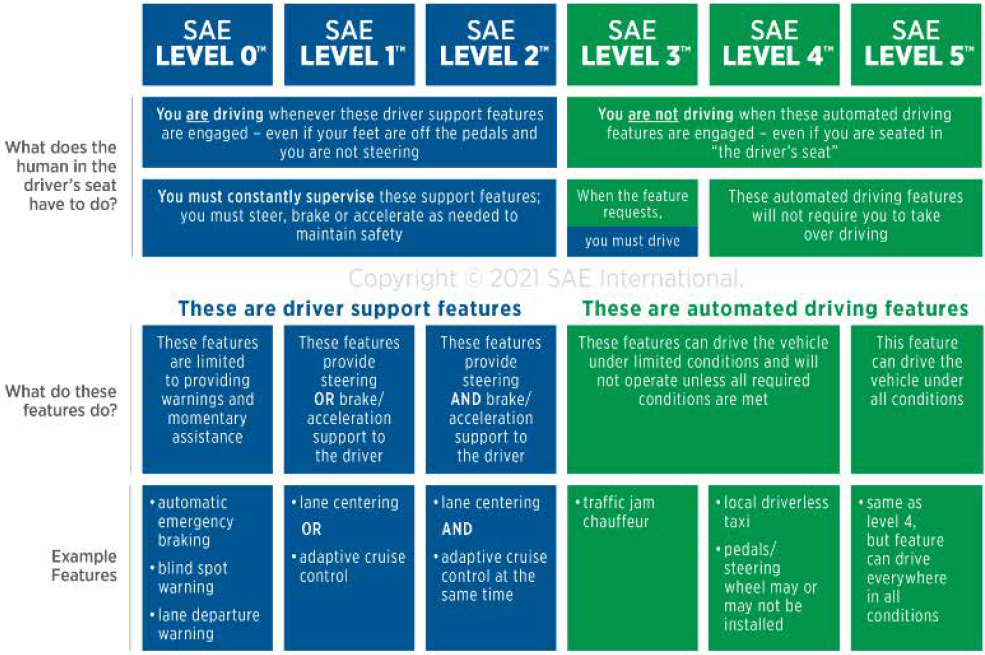
Table 18. Work Zone Related CV Applications – Interpreted from (Parikh et al., 2019)
| CV Application | Description |
|---|---|
| Automated Assistance in Roadwork and Congestion | Assists driver in complex work zone scenarios by using nearby objects (trucks, beacons, and guide walls) for guidance. |
| Automatic Emergency Braking | Activates brakes to avoid imminent forward collision. |
| Dynamic Speed Harmonization (SPD-HARM) | Recommends speeds in response to downstream congestion. |
| Queue Warning (Q-WARN) | Provides warning of impending congestion for awareness and safe braking or avoidance. |
| CV Application | Description |
|---|---|
| Reduced Speed/Work Zone Warning (RSWZ) | Alerts drivers to speed reduction, lane closures, or stops in a work zone. |
| Work Zone Intrusion Alarm | Warns personnel within a work zone about imminent dangers related to vehicles intruding into protected areas. |
| Emergency Electronic Brake Lights V2V Application | Warns the driver of stopped and slowing vehicles multiple vehicles ahead through V2V messaging. |
| Work Zone Traveler Information | Aggregates work zone traffic data for broad dissemination. |
In addition to technological and standardization challenges, policy and planning challenges exist at the state, regional, and local government levels that impact how ADS and CAVs are tested and deployed. Considerations for training how first responders interact and extract information from the vehicles and its occupants, legislation for how to assign liability or fault, and widespread updates to infrastructure are in the early stages of research and discussion.
ITS Conclusion
Even as newer technologies are evaluated and incorporated into work zones to enhance safety and mobility, fatalities persist. ITS technologies have increased driver adherence to posted work zone speed limits, improved merging behaviors, decreased the need for sudden or hard braking, and have better informed drivers about upcoming work zones and potential congestion. Even with CAV technologies on the horizon, human drivers will continue to be the primary point of focus for safety related technologies, especially in work zones, for a long time. Technologies are emerging that leverage new ways humans interact with the world around them, such as via crowdsourcing technologies and smart devices that allow for broad and collaborative communication with drivers, though at the cost of distraction. Connected technologies allow for real-time data collected within a work zone to be transmitted to individual drivers and their vehicles in place of broad road-side messaging that has often lagged real time conditions. These emerging technologies, and more, are discussed in the following chapter and describe how the creation and collection of work zone data can be utilized for real-time safety and serve to promote model work zone driving behaviors for the benefit of future technologies and safety system.
Emerging Technologies
CAV vehicle technologies are advancing rapidly as are the infrastructure technologies that accommodate them. The rapid advancement is partly due to the growing amount of research being published on the topic. In addition to FHWA’s repository of endorsed research literature involving ITS in work zones, other syntheses have been developed that provide updates on recent and ongoing research in the area. In August 2020, a report synthesizing research related to advanced technology for work zone management highlighted a number of efforts, many of which are also included in this literature review. The report focused on topics including collecting work zone event data, disseminating real-time data to human drivers, pilot tests and demonstrations, accommodating ADS in work zones, and utilizing advanced technology to improve worker safety in work zones (TTI, 2020). The following section provides an overview of emerging technologies that are currently being piloted, tested, or researched or are considered relatively new to the market.
Overview of Connected and Automated Vehicle Technologies
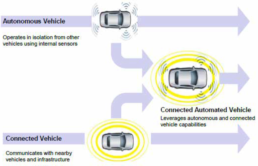
Understanding the nomenclature of what classifies a vehicle as connected or automated, or both, is an important first step into categorizing the technologies therein. CVs can communicate with other vehicles or their environments wirelessly. ADSs are hardware and software collectively capable of conducting a driving task without the input of a human on a sustained basis. Vehicles equipped with ADS are often colloquially referred to as automated vehicles (AVs) although this term is not recognized by SAE as official terminology. However, the use of AV persists through current marketing and research literature and rarely has a specific definition tied to it. The term CAVs also persists through the literature and refers to any vehicle that leverages both CV and ADS capabilities. The diagram in Figure 25, taken from the U.S. DOT (USDOT), describes the relationship between AVs, CVs, and CAVs.
CVs collect information from their environment through four main types of connectivity: V2V, V2I, vehicle-to-cloud (V2C), and vehicle-to-pedestrian (V2P). Other communication modes have been proposed and are discussed lightly in the literature; however, these four represent the main pillars of connectivity related to work zones within the vehicle-to-everything (V2X) paradigm.
Vehicle-to-Vehicle (V2V)
V2V relies on communications between nearby vehicles to provide advanced warnings to drivers about dangerous situations that lie ahead. V2V applications encompass many popular ADAS including those recognized by NHTSA (USDOT, 2014), such as forward collision warning (FCW), blind spot warning (BSW), lane change warning (LCW), do not pass warning (DNPW), left turn assist (LTA), automatic emergency braking (AEB), electronic emergency braking light (EEBL), and intersection movement assist (IMA).
Vehicle-to-Infrastructure (V2I)
V2I, sometimes referred to as infrastructure-to-vehicle (I2V) depending on the origination of communication, relies on nearby infrastructure to communicate a status or warning to drivers. Commonly recognized V2I applications include intersection movement assist (IMA), red-light violation warning (RLVW), stop sign violation warning (SSVW), and curve speed warning (CSW). Three applications pertain directly to work zones, as described by Parikh et al. (2019):
- Reduced Speed/Work Zone Warning (RSWZ): uses RSUs to broadcast upcoming work zone alerts to drivers.
- Warnings about Hazards in a Work Zone: warns work zone personnel about potential intrusion threats.
- Warnings about Upcoming Work Zone: provides advanced warning to approaching drivers about obstructions, lane shifts, lane closures, speed reductions, or maintenance vehicles entering or exiting a work zone area.
Vehicle-to-Cloud (V2C)
V2C makes use of the IoT and the interconnected web of information and data streams that may include data from vehicles and infrastructure in addition to data transfers from sources like crowdsourcing applications and other public APIs.
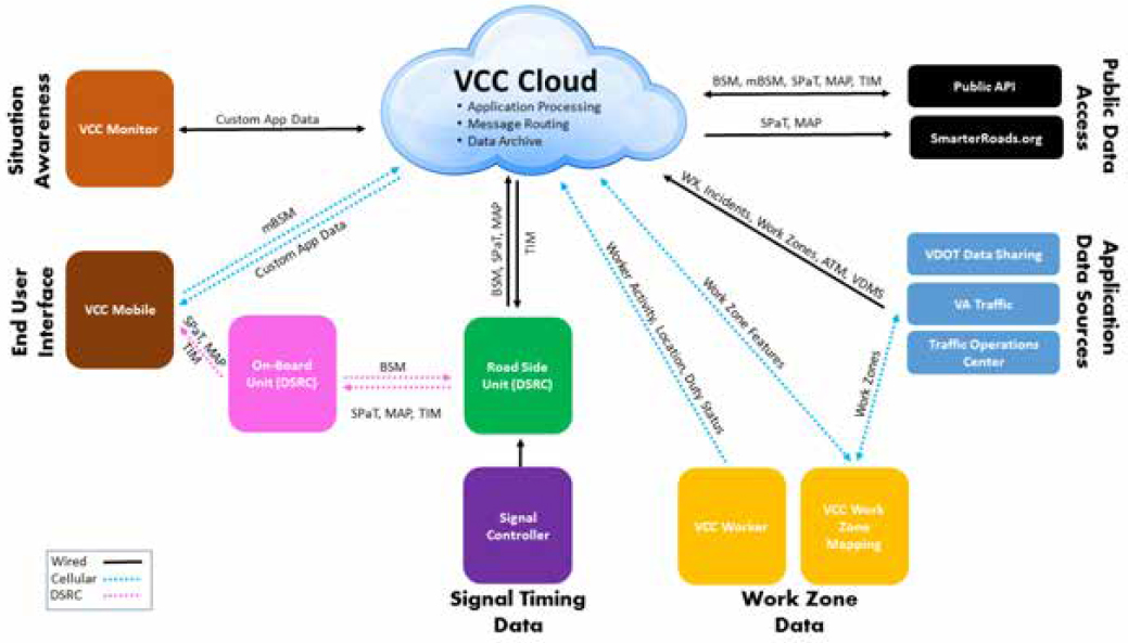
The Virginia Connected Corridor (VCC) is one example of a V2C network that acts as a centralized system that receives and transfers data from multiple sources and distills it into conveniently retrievable information through a user interface. In partnership with VDOT/VTRC, VTTI has worked over the last 9 years to develop and build the VCC, an open CAV environment with testbeds located at the Virginia Smart Roads in Blacksburg, VA and in Northern Virginia. The VCC Cloud provides a centralized system that supports the management of CV message traffic between entities interacting on the corridor. The system currently supports connection via cellular communication and dedicated short-range communication (DSRC) and can be adapted to support other communications technologies that may materialize in the future. Both real-time and historical data are readily accessed by applications through the cloud infrastructure. The current VCC cloud implementation can support several thousand end users; however, additional work is required to migrate the systems to production scaling, security, monitoring, etc. The VCC currently includes seven DSRC Roadside Units (RSUs) on the Virginia Smart Roads and 49 DSRC and 11 C-V2X/5G RSUs in the Northern Virginia testbed. Thirty of these 49 DSRC and all 11 C-V2X/5G RSUs in Northern Virginia are interfaced directly to signal controllers to support signal phase and timing (SPaT) message broadcasting on three separate arterial corridors. In addition to the RSUs, a real-time kinematic (RTK) base station was installed at an intersection in Merrifield, VA to provide position correction information that can be utilized by dynamic RTK rover receivers and OBUs for CAV applications that require centimeter-level GPS accuracy.
The VCC includes interfaces to VDOT’s data sharing systems where it retrieves active work zone information and converts it to the appropriate J2735 Traveler Information Message (TIM) format. The TIM messages are forwarded to the local RSUs where they are broadcast over DSRC or C-V2X protocols to any connected vehicles in the region. The messages are also made available to 3rd party users through a secure public application programming interface. VTTI has developed and tested its own cell phone application that retrieves the messages and conveys their content to drivers as they enter the geolocation for each message.
A diagram illustrating the interconnection of data sources through the VCC cloud is found in Figure 26.
Vehicle-to-Pedestrian (V2P)
V2P systems exist to improve pedestrian safety using vehicle-based or smartphone-based technologies. Vehicle-based V2P technologies detect pedestrians using vehicle mounted sensors and alert drivers through the vehicle HMI or through infrastructure signage. Smartphone-based V2P technologies alert a pedestrian via their smartphone when they are about to be in a dangerous situation. Infrastructure-based technologies provide bilateral alerts to both drivers and pedestrians about a potential collision. The Pedestrian Technology Test Bed in McClean, VA, was established to assess multiple market- ready V2P technologies on their effectiveness at reducing collisions with pedestrians (FHWA, 2019d). Some of main challenges of V2P technologies are in the accuracy and reliability of the GPS sensors used in the cell phones which preclude the possibility of providing localized individual warnings to users consistently without false alarms. Further, the latency of the communication between the vehicles and cell phones because of the cellular networks could also add to the reduced effectiveness.
The focus of V2P has not previously been overtly tied to work zone personnel safety although any technology capable of detecting pedestrians will also be able to detect workers and provide notifications. It is worth noting that V2V, V2I, V2C, and V2P communications do not operate exclusively, and as a result a wearable technology that can alert work zone personnel to an intrusion from a specific direction utilizes infrastructure, cloud, and pedestrian to work. One such technology is described in further detail in Personal Warning Sensors.
Crowdsourcing Technologies
Crowdsourcing technologies allow for information to be either manually or automatically collected and shared with a large number of people who also enlist the services of the technology. Some crowdsourcing applications allow users to opt-in regarding the information they share while other applications capture information without the user’s direct knowledge. In general, these applications allow for information to be regularly updated and curated by the general public.
Waze
Waze is a mobile application that provides users with up-to-date navigation instructions by incorporating crowdsourced data. Data are collected and submitted by users as they travel along a route and this data is accessed by downstream users who can leverage the information for making route-based decisions. Waze has over 140 million users with the ability to add information on the events they encounter such as traffic delays, incidents, hazards, and road closures (Waze, 2020).
Prior to the 2016 Olympics, the city of Rio de Janeiro utilized Waze’s slow-down and traffic jam alerts when considering the locations for three new highways meant to alleviate traffic associated with the upcoming event. Waze created an “unusual traffic alert” feature and also utilized map editors to update sections of map data in preparation for the event. Once the event began, a new version was released that would “automatically update the Waze map with road closures” (Waze, 2020). Due to the crowdsourcing functions of Waze through its 800,000 monthly users in Rio, along with the updated maps (Chang, 2016), there was a 24% to 27% decrease in traffic delays when travelling in the morning during the event (Waze, 2020).
Ghent, Belgium aimed to decrease traffic in the city center by 40% through restricting access to the main arterial roadways (Waze, 2020). This effort was part of Waze Connected Citizen’s Program (Waze, 2018) and required significant changes to the map data including 14 road closures, 1,800 traffic sign changes, and updated directions for navigating on 88 streets. As a result, the city center was divided into different zones where it was considered “physically impossible to drive from one part of the center to another” and vehicles were rerouted. It is reported that there has been a 30% decrease in vehicle accidents, a 15% increase in bus and tram use, and a 27% increase in cyclist presence since the changes were implemented (Waze, 2020).
Waze data has also been utilized by a work zone performance monitoring application (WZPMA) that was developed at the University of Maryland in conjunction with the Maryland State Highway Administration (MDOT SHA) and the FHWA (Sadabadi et al., 2016). WZPMA includes integrated data from three sources: a probe data analytics (PDA) suite, state DOTs Advanced Traffic Management System (ATMS), and a Regional Integrated Transportation Information System (RITIS). The PDA suite utilizes Waze and other third-party data to provide agencies with information on traffic, travel, congestion, as well VDOT partnered with Waze through its Connected Citizen Program (Herman, 2016) and currently maintains that partnership (VDOT, 2021). Through this partnership, Waze provides crowdsourced information about incidents and slowdowns on Virginia roadways to VDOT to be incorporated into the state’s 511Virginia traveler information system. In turn, VDOT provides Waze with data from its 511Virginia system regarding incidents, road closures, and verified work zones. This partnership allows both entities to offer their users more extensive information to aid in efficient navigation and avoid delays throughout the commonwealth (Herman, 2016).
Other state DOTs have also partnered with Waze for work zone management such as the Kentucky Transportation Cabinet (KYTC) and Port Authority of New York and New Jersey
(PANYNJ). Similar to VDOT, KYTC integrates traditional and crowdsourced data into its traveler information system for public access. Additionally, for personnel at Kentucky’s Traffic Operation Center (TOC), KYTC created “work zone monitoring maps and dashboards” (FHWA, n.d.) that feature an email alert system. PANYNJ partnered with Waze for a detour management system that utilizes the application’s ability to notify drivers about upcoming work zones and alternative routes (FHWA, 2021a). For example, the recent redevelopment of New York City’s LaGuardia Airport included a temporary ramp (PANYNJ, 2019) and the PANYNJ sent notifications to over 140,000 targeted users (FHWA, 2021a) suggesting they use the ramp during periods of high traffic congestion (PANYNJ, 2019).
Google Maps
Google Maps is a mobile application that features navigation instructions from a variety of sources that have been acquired over time (Google, 2021). Prior to launching Google Maps, in 2004 Google acquired the 3D mapping company Keyhole and their EarthViewer mapping service became the foundation for Google Earth while portions of the data were utilized for the development of Google Maps (Orlowski, 2004). In 2005 Google acquired ZipDash which featured a traffic speed database as well as crowdsourced data functions to provide users with real-time traffic information (Bazeley, 2005; Matthews, 2013). In 2019 Google Maps added the ability for users to report traffic related events they encounter including traffic delays and speed traps as well as incidents such as crashes, lane closures, and disabled vehicles (Tseng, 2019). According to Google’s own press site (accessed July 2021), Google Maps has over one billion users with over 50% of users accessing the service through a mobile device (Google, n.d.).
Google Maps data was utilized by a Smart Work Zone Activity application (SWiZAPP) that was developed at the University of Missouri-Columbia in conjunction with the Iowa State Highway Administration (IDOT SHA) and the FHWA. SWiZAPP can operate as a Work Zone Alert Management System that can be used by traffic management centers or third-party providers to update road users about lane closures or other changes to work zones along their routes. The app can also serve information management and tracking functions for contractors and work zone managers. Additionally, SWiZAPP supports work-zone geolocation and mapping via on-board GPS sensors and Google Maps, respectively. Further crowdsourcing features include the ability to upload images and select traffic conditions in active work zones such as crashes and traffic queues, as well as lane activity conditions including an open, restricted, or closed lane (Adu-Gyamfi et al., 2019).
TomTom GO
TomTom GO is a subscription-based mobile application that offers fully offline maps that are updated weekly and provide real time navigation that incorporates crowdsourced traffic data (TomTom International, 2021). TomTom’s crowdsourced data comes from its 800 million users across the company’s mobile application, as well as its hand-held and integrated devices (Sekinah, 2019). In 2019, TomTom released a Map Styler function that allows users registered as developers to customize maps for a variety of applications such as highlighting points of interest or guiding users around an unfamiliar location. Map Styler features include the ability to choose a base map layer, select color and font for labels and roads, create large polygon figures, as well as the ability to limit which map features are displayed at different zoom levels (TomTom, n.d.).
In late 2020, TomTom launched RoadCheck which provides automated vehicle manufacturers the ability to limit where drivers can activate the vehicles’ automated driving functions. The ODD can be defined on TomTom’s high-definition map to limit automated driving during conditions such as adverse weather, driving in tunnels, and in changing environments like work zones
(TomTom International, 2020). This new feature adds to the service provided by TomTom’s ADAS Map that is operating in SAE Level 1 and Level 2 automated vehicles. The ADAS Map offers information to driver assistance systems such as grade, curvature, and speed limit (TomTom International, 2019).
TomTom has participated in projects to evaluate the effectiveness of their products in reducing congestion. In Maastricht, Netherlands, a consortium of construction companies called Avenue2 contracted with TomTom to decrease congestion around a long-term construction project. The project was scheduled to operate for five years while building a tunnel underneath a heavily travelled roadway. The partnership allowed the traffic impact of the construction zone to be monitored “to ensure that any inconvenience due to the road works will be kept within the agreed limits” (TomTom International, 2011). Since the tunnel began operating in 2016, “80% of all traffic runs underground and no longer crosses Maastricht” and the city has been able to develop a large recreational area where the roadway previously existed (Rijkswaterstaat, 2019). While specific metrics about congestion reduction during this project could not be obtained, TomTom Traffic provides agencies with percentages that indicate the congestion levels at different times of day. Color coded figures correspond to the percentages and indicate the severity of congestion so agencies can make decisions regarding reduction (TomTom International, n.d.).
Researchers at the New Jersey Institute of Technology aimed to develop an artificial neural network (ANN) model that utilizes probe vehicle data to estimate work zone delays. The probe vehicle data consisted of both discrete and continuous data sources. The discrete data was collected on a New Jersey highway by calculating the time it took vehicles to travel between tag readers at fixed locations along the roadway around the work zone. The continuous data was provided by commercial vendors TomTom, INRIX, and HERE. The model developed by researchers was compared with traditional deterministic queuing models and found to be more accurate at estimating the duration of the delay per vehicle, the cost of the delay, and the maximum queue length (Du et al., 2016).
Probe Data Vendors
Probe data is usually generated by monitoring individual vehicles (also called as probes) along routes of interest (Mudge et al., 2013). This data can be generated by using an actual vehicle to traverse through a road of interest or through sensors like Bluetooth readers, toll tag or license plate readers, GPS mobile devices or through cell phone tracking. The probe data thus collected has been used by state agencies to develop performance measures for work zones. Probe data based on GPS and cellular data have the capability to calculate performance measure for different kinds of work zones while Bluetooth sensors have limited applicability but can provide supplementary data to aid other existing sensors. For example, a delay in travel time can be calculated by comparing the time taken for a probe vehicle when a work zone is present on a corridor compared to when there was no work zone. With the help of probe data, in some cases, estimates of vehicles speeds and/or queue lengths could also be calculated.
Probe data is either collected by state agencies or third-party vendors. The data generated by agencies or agency-contractors is same as the data that generated from traffic monitoring in work zones by the agencies. There are several third-party probe data vendors that collect traffic data all over the United States: INRIX, TomTom, NAVTEQ, AirSage, and TrafficCast. These third-party vendors collect data using several sources, such as GPS data from fleet management companies, navigation data from private vehicles, cell phones, and fixed infrastructure sensors that are owned by the vendors. The data thus acquired is aggregated and can be provided at intervals of 15 to 60 minutes. These vendors also anonymize the data collected to remove personal identifying
information (Mudge et al., 2013). Research that evaluated the applicability of probe data for real time traffic performance monitoring showed that they could have speed bias and should be supported by probe data from sensors mounted on infrastructure (Sharma et al., 2017).
State DOT Application of Crowdsourced Data
State DOTs have utilized crowdsourced data from social media platforms, third-party providers, and specialized mobile applications (FHWA, 2020a). The crowdsourced data types include probe vehicle data that contains speeds and travel time, event data reflecting incidents and weather conditions, travel behavior data on where users travel and the mode of transportation they use, social media data containing public perceptions, vehicular data such as quick deceleration, and mobile infrastructure data such as work zone cones providing location and speed data for passing vehicles (FHWA, 2019a). Access to crowdsourced data can improve operations by providing agencies with information needed to enact strategies aimed at reducing congestion (FHWA, 2020a). Use of crowdsourced data can also increase safety through quick processing of traffic incidents and congestion leading to faster responses and reducing the risk of additional incidents. Additionally, crowdsourcing can increase work zone safety through accurate zone boundaries and up to date information on new work zones. Monitoring capabilities are expanded with crowdsourcing and allow agencies to increase “their geographic coverage area and overcome jurisdictional stovepipes” because the data is created by users travelling in those areas (FHWA, 2019a).
Alabama
Alabama for example has developed ALGO, a traffic application for computers and mobile devices that uses information from Alabama DOT (ALDOT) to provide updates to roadway conditions and environments across the state. ALGO offers an interactive map where users can select layers to apply including camera locations, road work, crashes, incidents, national weather service alerts, and traffic speed information. Additionally, work zones and incidents can be selected so more details can be viewed. Traffic reports and travel times are compiled for easy review and live camera feeds can be watched directly through the application as well. ALGO is currently accessible for free online and via major mobile application stores (Alabama DOT, 2020). As of 2020, FMCSA and ALDOT are working to update the ALGO Traffic mobile application to provide notifications about work zones. Notifications are provided to road users as they approach a work zone alerting them about the zone’s location and the estimated distance (TTI, 2020).
Virginia
VDOT has improved 511Virginia by utilizing crowdsourcing data from Waze and Google. The application utilizes Waze’s “Deep Links” application program interface (API) to power the navigation feature (FHWA, n.d.). 511Virginia includes an interactive map with overlay and icon options that can be selected. Overlay options include road conditions, traffic speeds, and precipitation. Icon layers incorporate options such as road work, incidents, camera locations, rest areas, and electric vehicle charging. Additionally, Waze reported events can be selected as icon layers encompassing crash, congestion, hazard, and shoulder events. 511Virginia is currently accessible for free online and via major mobile application stores (VDOT, 2021).
VDOT is using probe vehicle data sourced from a 3rd party vendor to quantify performance in work zones relating to delays and congestion on a macro and micro level. On a macro level, delays are used as the main performance metric for evaluating “recurring and non-recurring delay at the statewide, district, and corridor levels”. Non-recurring delays include inclement weather, crashes
and other related incidents, holiday travel, and work zones. According to VDOT’s analysis “in 2016 and 2017, non-recurring sources contributed to about 24% of total statewide delays in Virginia with work zones contributing an estimated 4% and 8%, respectively.” On a micro level probe vehicle data is utilized to measure congestion and travel time associated with specific projects. VDOT’s probe vehicle data comes from INRIX’s speed and travel time data that utilizes GPS trajectory information obtained from a “wide array of commercial vehicle fleets, connected cars, and mobile applications”. The combination of macro and micro data allows for the agency to identify and understand contributing factors as well as employ strategies to resolve them through policy and procedures (FHWA, 2019c).
Maryland
A project with the FHWA to demonstrate the usefulness of probe vehicle data reported an overview, measures that can be captured by probe sources, and discussion of applications for the data. Additionally, a pilot project was conducted with the University of Maryland Center for Advanced Transportation Technology for Maryland State Highway Administration. Probe vehicle data can be collected by agencies that establish infrastructure to collect the data or through third party companies collecting the data for commercial products. Agencies employ toll tag readers and Bluetooth readers that detect when an enabled device passes and calculates travel time based on the rate it passes by additional readers. Vendors for third party probe data acquire their data through GPS-enabled fleet management systems, navigation data from private vehicles, data from navigation mobile applications, and fixed sensors.
The pilot project developed a WZPMA to monitor the work zone and provide assessments based on available probe data integrated with RITIS. The WZPMA was discussed above in relation to its PDA suite’s utilization of Waze data. The WZPMA features a RITIS comprised of three parts including real time data feeds, real time situational awareness tools, and archived data analysis tools. Real-time data feeds offer access to “multiple data sources, including incident, detector, probe, weather, transit, TOC communications, and others.” Real time situational awareness tools include a dashboard display to show work zone activity, a map of the location, speed summary, performance measure timelines, a speed heat map, and live video feeds. RITIS can aid agencies in monitoring and understanding the details surrounding congestion in active work zones as well as the cost of delays and impact on mobility (FHWA, 2020d). Additional uses include oversight of work zone activities, supporting traffic operations, updating the public, responding to requests for extensions, and replying to public concerns (Mudge et al., 2013). It is important to note that the technologies utilized by Maryland in this deployment, such as RITIS and its supporting applications, are widely used by many state DOTs and not Maryland alone.
Work Zone Intrusion Alert Systems (WZIAS)
Intrusion alarms or alerts allow workers to be notified of a dangerous threat through audible or haptic notifications. Sensors placed on the perimeter of a work zone algorithmically determine if a vehicle approaching a work zone is traveling at a speed that puts workers at risk if it cannot or does not slow in time. Commercially available, WZIAS have been evaluated and determined to be overall beneficial both financially and more importantly, for worker safety. Eseonu et al. (2018) found that the study’s model predicted intrusion-related injuries and fatalities could potentially drop 12% to 34%, depending on the technology, which would lead to between 98% to 136% return on investment.
In general, there are two types of WZIAS defined by their method of detecting intrusions. One type can provide advanced notifications by predicting an intrusion before it occurs, and the second type provides alerts after a vehicle enters the work zone’s perimeter. The technologies can be broken down further by the type of technology they employ for detection. A study by Marks et al. (2017) reviewed commercially available intrusion technology circa 2017 and defined five detection technologies: kinematic, infrared-based, pneumatic and microwave, radar-based, and radio-based.
Beyond the method of detection lies the method of notification. There are multiple notification mechanisms for how workers are alerted to intrusion threats, including but not limited to flashing lights, audible alarms, radio notifications, and personally worn device alerts. Alert mechanisms are not mutually exclusive either, as a redundant mechanism or alert method is often recommended per human factors requirements.
As noted by the efforts of this literature review and similarly stated by Nnaji et al. (2020) in their systematic review of work zone safety technologies, studies on cost-effectiveness are lacking on this topic. Such data requires a DOT to make an investment in a technology as an intervention and provide before and after data. For work zone intrusion alarms, it may be too soon to expect cost-effective insights.
Intellicone
Intellicone is a radio-based WZIAS that uses a Portable Site Alarm or Traffic Management Unit along with LED sensors that are mounted on cones or barrels to create a perimeter where impact can be detected and transmitted. The Intellicone LED sensors also serve as sequential lighting devices (similar technology is discussed in Advanced Channelizing Devices section). An accompanying device, the Intellicone Sentry, is a sensor that uses an ultrasonic beam technology with a 3-meter range to monitor the zone entrance. The Portable Site Alarm provides three different warning tones and different models are commercially available to support a range of work zone operations. The Y-Series model is specifically web enabled, rather than utilizing a short-range radio frequency, which allows the range to exceed 50 meters and connect multiple devices. The Traffic Management Unit is designed for remote barriers and unmanned sites featuring a more discrete design with tamper warnings. Both models provide text message alerts for workers, GPS location tracking, and web portal reporting (Trans Canada Traffic, n.d.).
In 2018, researchers Nnaji, Gambatese, and Lee evaluated work zone intrusion technologies and noted the Intellicone’s combination of different alert methods may increase awareness and allow workers additional time to evade the intrusion threat. Additionally, they report the Intellicone and similar devices are simple to deploy and require minimal setup and retrieval time for workers. Limitations discussed were the need to continuously move devices in mobile operations and the auditory alarm not exceeding the decibels produced by large equipment such as an asphalt truck or compactor. The volume was noted to be 75 dB when 50 ft away from the device (Boodlal et al., 2020). Cost was also evaluated for a mile long work zone and the Intellicone equipment needed was estimated to cost $2,400 (Nnaji et al., 2018).
Sonoblaster
Sonoblaster is a kinematic-based WZIAS that is mounted on cones, drums, and other barricades (Sonoblaster, n.d.). The device is mechanical with a carbon dioxide (CO2) cartridge that activates an alarm when tilted or impacted (Nnaji et al., 2018). The alarm is advertised as 125 dB and alerts passing drivers and site workers of a potential intrusion. However, it is reported that the sound only reaches 90 dB when positioned 50 feet away (Boodlal et al., 2020). The device costs $89.95
per unit (Sonoblaster, n.d.) and replacement cartridges cost $39.95 (Cartridge, n.d.) making it adaptable for large and small work zones. Cost was estimated at $1,260 for a 1-mile stretch of road (Nnaji et al., 2018).
NJDOT funded a study in 2010 evaluating the Sonoblaster’s effectiveness as a WZIAS. Pilot testing was conducted and found the sound levels to be audible at 200ft even with ear protection. However, testing in conjunction with other equipment was not conducted. It was reported that mounting the devices was time-consuming, but authors note the cones can be stacked once mounted. The device was described as “very sensitive and must be handled carefully” and safety personnel expressed that the devices would often activate during transit. Additionally, personnel described prepping the devices prior to deployment as being unable to hold the locked position saying they frequently activated during installation (Krupa, 2010). Work conducted by Nnaji, Gambatese, and Lee echoes this sentiment saying the alarm produces many false positives and isn’t conducive to moving the devices as the work zone operation progresses (Nnaji et al., 2018).
In 2014 a closed course test and field test were conducted to compare Intellicone to Sonoblaster. Closed course testing focused on the sound levels and sound distribution while field testing focused on worker surveys assessing perceptions of the system’s “effectiveness, suitability, and benefits.” The maximum sounds level was evaluated with a sound meter placed at incremental distances from the devices. Field testing with participants indicated workers felt the Intellicone system was challenging to hear over work equipment despite the differences in tone.
Intellistrobe
Intellistrobe is an Automated Flagger Assistance Device (AFAD) that also functions as a pneumatic-based WZIAS controlled by a human flagger operating a handheld transceiver (Marks et al., 2017). The device is advertised as quick and easy to set up and includes a trailer with two lightweight wheeled cabinets. The cabinets each include lights, gate arms, and added stabilizers. The intrusion alarm feature is activated by the flagger via the transceiver or an automated function (IntelliStrobe, n.d.). The automated function was referenced by researchers who described it as a pneumatic hose that triggers the alert when a vehicle passes over (Nnaji et al., 2018).
Traffic Guard Worker Alert System (TGWAS)
Traffic Guard Worker Alert System (TGWAS or WAS), uses a pneumatic microwave-based detection system and provides auditory, visual, and haptic alarms. Astro Optics advertises the device as having a 1,000 ft range but specifies the device as a “Warehouse Audible” system, suggesting the device is marketed for an indoor environment as opposed to an outdoor highway work zone environment (System, n.d.). The personal safety device (PSD) unit is an optional accessory with the kit and comes with an added cost per unit (aoindustrialsupply.com, n.d.). If a vehicle drives over a pneumatic tube positioned at the perimeter of a work zone, it triggers the alarms, including an audio alarm that achieves 80 decibels at a span of 50 feet (Boodlal et al., 2020).
Personal Warning Devices
AWARE
Advance Warning and Risk Evasion (AWARE) is a radar-based work zone intrusion technology developed by Oldcastle Materials Inc. that can monitor a work zone environment by tracking workers, work vehicles, and intrusion threats. The system incorporates an intrusion alarm applied to the perimeter of a work zone and detects vehicles crossing the perimeter’s threshold (Ullman &
Theiss, 2019). The AWARE device has long-range and short-range detection operating at 500 or 200 feet in length with a 10-degree or 45-degree width on both sides of the center line respectively (Theiss et al., 2017). The device can be mounted onto existing equipment or a work vehicle and includes flashing lights and an audible alarm aimed toward approaching traffic. Worktrax is the name of an accompanying device that provides workers with an auditory or haptic vibration when an intrusion is detected. The Worktrax device can be mounted inside a hard hat or placed inside the worker’s vest. It was reported that Oldcastle is working to continue testing and trying to identify a manufacturer/distributor that can make AWARE commercially available (Ullman & Theiss, 2019).
In 2016, TTI contracted with Oldcastle Materials to perform testing of the AWARE system and accompanying Worktrax device. They evaluated whether the intended alarm initiated appropriately within the designated range and evaluated the frequency of false alarms. Testing was conducted on a closed course at TTI and involved staging a work zone with researchers operating instrumented vehicles under various conditions. Researchers developed three scenarios for lane closures in tangent alignment, right curve alignment, and left curve alignment. Additionally, five trajectories with different maneuvers were developed within each for the intended outcome of activating or not activating the alarm. To verify the system’s accuracy, Worktrax data was compared with time-synchronized video data. Results showed that the AWARE system performed at a 100% success rate and the Worktrax device performed at 97% success rate. The authors noted that “unsuccessful events for the Worktrax device were attributable to limitations in the effective communication range of the intrusion detection system with the Worktrax device.” The researchers noted that the system was tested in lane closure scenarios but expect the system to function well in a mobile environment (Theiss et al., 2017).
In 2018, a human factors experiment was conducted to evaluate how motorists respond to the flashing lights and alarms of AWARE as well as whether those features contribute to unwanted driver reactions such as swerving or hard braking. The results showed no adverse effects for passing vehicles who encounter the system but noted that the auditory alarm should be modified to differentiate it from emergency vehicle sirens. System performance testing focused on the accuracy of intrusion detection and the timeliness of the alarms. Researchers found the system to have a high degree of accuracy with a nearly perfect ability to detect intrusions and send alerts through the AWARE system and Worktrax, verifying previous research results (Ullman & Theiss, 2019).
A series of field experiments was conducted evaluating worker responses to intrusion alarms as well as crash determination based on outcomes. Researchers considered three types of technologies: Impact Activated Systems (IAS), Radar Activated Systems (RAS), and a pneumatic Pressure Activated System (PAS). Based on the results, researchers suggest IAS in work zones using channelizers over long tapers because the range of 300 ft from sensor to site alarm accommodates 30 mph roadways. Additionally, they concluded that the IAS was better suited for long term work zones due to the length of setup time. When comparing IAS to PAS, they found that after three seconds IAS resulted in a “greater probability of survival”. PAS were suggested for short term or mobile work zones because it allows for quick and simple deployment. The PAS range is 150 ft from sensor to personal alarm making it optimal for environments with speeds less than 30 mph. RAS was considered best for work zones with flagging operations and speeds less than 40 mph. Based on the assessment, RAS was determined to be ideal for work zones with medium length tapers because the range is 400 ft from sensor to personal alarm (Thapa, 2021).
Smart Vest
In 2019, researchers at VTTI aimed to expand the capabilities of work zone intrusion alarm technology (WZIAT) by developing an all-inclusive system that considers the movements and positioning of actors within and outside a work zone. The project’s objectives were to utilize the DecaWave ultra-wide band (UWB) technologies to support localization, develop algorithms to aid in the prediction of work zone and vehicle movement based on their trajectories, and provide real time threat detection and alerts for CV/CAVs. The DecaWave system achieved a range of 80 meters because outdoor environment posed additional limitations that aren’t present in enclosed environments. The algorithm was developed based on four sets of experiments conducted in different sections of VTTI’s Smart Road test track while construction activities were simulated. In each section, two sets of data were collected; data to train the algorithm model and data for evaluating the alert precision. The resulting algorithm model was able to achieve 76% accuracy. Additional testing was done to ensure the study’s VCC Cloud server was effectively communicating with VCC Monitor as well as sending alerts to driver’s VCC Mobile application. Using the algorithm and WZIAT, approaching vehicles received proximity messages and warnings were displayed on the VCC Monitor. These alerts were generated when vehicles came within 100 meters of work zone personnel with consideration for the trajectories of each actor. Ultimately, due to limitations the of the system, researchers suggested the technology is not optimal for an outdoor environment and “would not work well in the roadside WZ use case” (Mollenhauer et al., 2019).
VTTI continued researching WZIAS with a focus on developing a Smart Vest that can identify intrusions, track vehicles, equipment, and personnel, as well as consider potential collisions based on trajectory. The vest employs the previously developed algorithm model to “communicate potential collisions to workers, passing drivers, and connected and automated vehicles (CAVs).” Human machine interface (HMI) modes utilized flashing lights for visual signaling, vibrations for haptic signaling, and speakers for auditory signaling. A receiver provided real time kinematic (RTK) GPS data and a communication module was used for transmitting between the vest and the gateway that houses the algorithm. This module sends RTK GPS data and HMI requests to activate the sensors on the vest based on the algorithm. The gateway also interprets work zone boundaries through a polygon plot that can be established two ways; through a node without an HMI component that acts as a plotting device or via a Work Zone Data Management App. The vest features a low-level warning when within 1 meter of a work zone boundary and a high- level warning when the boundary has been reached or crossed. Field testing was conducted in Elliston, VA at an active construction site and verified the communication range was operational in a zone with a 500-meter length (Mollenhauer et al., 2021).
Traffic Guard Worker Alert System (TGWAS)
Traffic Guard Worker Alert System (TGWAS) features an alarm unit as well as Personal Safety Devices that are battery operated. The Worker Alert System’s Personal Safety Device produces haptic vibration and an alarm that is transmitted through an included earpiece or via an AUX jack. The devices connect wirelessly to the alarm unit; however, the connection range is not provided (Astro Optics LLC, n.d.). Marks et al. compared the Traffic Guard Worker Alert System to other WZIAS such as Intellicone and noted that the Personal Safety Device experienced transmission delays ranging from 1-2.5 seconds with a 0.37 second delay on average across 15 trials. However, no false alarms were produced. And this technology may potentially work for short tapers, short - term, and mobile highway construction projects (Marks et al., 2017).
Under Development
Researchers at East Carolina University worked in conjunction with NCDOT to explore the viability of IoT, artificial intelligence (AI), and computer vision technology to enhance work zone safety. Two proof of concept warning systems were developed that focus on work zone intrusion detection and queue detection. The intrusion detection system uses a single mobile device camera that is mounted on a tripod and placed facing the detection zone or taper leading to an active work area. Researchers determined the system can monitor a range up to 200 meters long that is defined by drawing a polygon. If a vehicle enters the polygon, an alert is sent to work zone personnel’s mobile devices and results in vibrations and an auditory alarm. The system can also be set up to only provide alerts when a vehicle passes the threshold travelling at a given speed. The testing indicated that the system has an accuracy between 99% and 92.3% depending on lighting and precipitation. The queue detection system operates similarly to the intrusion system. Users draw a polygon for the area they want to monitor and calibrate the system thresholds to identify a stopped vehicle within that area. Results of testing indicate that the system operates with 93.4% accuracy in clear daytime condition, however daytime precipitation and nighttime conditions have lower accuracy at 66.6% and 80.7% respectively (Ozan, 2020).
Advanced Warning Technologies
HAAS Alert
HAAS Alert has a digital warning system of the same name that uses their own Safety Cloud technology to communicate with navigation apps and in-dash systems to alert road users when emergency vehicles are approaching with activated lights. HAAS Alert offers products to accompany its Safety Cloud such as a vehicle transponder that can be integrated with a vehicle’s current system and transmits information when flashing emergency lights are engaged. HAAS Alert also offers responder-to- responder alerts that can prevent collisions by notifying emergency vehicles when other HAAS Alert- equipped emergency vehicles are approaching the same intersection. Additionally, HAAS Alert offers a Situational Awareness Dashboard that allows for fleet locations to be tracked and alert status to be viewed (haasalert.com, n.d.). According to the company’s website, HAAS Alert’s Safety Cloud is a standard safety feature on first responder fleet manufacturers and accessed by public safety departments and DOT fleets in over 100 U.S. cities. To date, the company asserts that its safety service has processed over 200,000,000 driver alerts (haasalert.com, 2020b).
The fire department in Crestwood, Missouri, implemented the Safety Cloud technology in conjunction with HAAS Alerts vehicle transponder to send alerts to Waze users when their fire trucks approach from behind. HAAS Alert has partnered with Waze for alerts to be sent to drivers through the application and is working to partner with similar crowdsourcing companies. During the first seven months of service in Crestwood, HAAS Alert sent notifications to 2,397 drivers. It is reported that the Safety Cloud provides a low-cost option to increase safety and communicate with drivers to slow down around emergency vehicles (Kenworthy, 2020).
In 2019, HAAS Alert conducted pilot testing in Chicago using Sprint’s 5G network and a fleet equipped with cellular vehicle-to-everything (C-V2X) technology. Average alert transmission time on an LTE network was found to be 0.796 seconds (SD = 0.388) and was to 0.549 seconds (SD = 0.107) found using the 5G network. Results indicate 5G alert transmission and reception were sent 40% faster with a 40% reduction in variance compared to a standard LTE network. This was attributed to the “increased speeds and lower latency” of the 5G network and demonstrates
it’s “potential to enhance public safety” (Supplier News, 2019). Additionally, the state of Illinois plans to make move over laws more robust to increase public awareness. This technology has the potential to assist road users with adherence by providing them alerts with more advanced notice than traditional methods of hearing sirens or seeing the emergency vehicle itself (Walz, 2019).
In 2021, the Indiana DOT partnered with HAAS Alert and outfitted their maintenance fleet vehicles with the Safety Cloud system. The effort is part of a work zone safety strategy aimed at reducing risk during the exceptionally busy construction season the state will undergo. Digital alerts are believed to give more notice to drivers about upcoming work zones and provide more time for drivers to slow down, thus reducing collision risk by up to 90% (haasalert.com, 2021). The project is following up research conducted in 2020 with the Joint Transportation Research Program that also included queue trucks and automated queue warning systems (Indiana DOT, 2021).
Pi-Lit (described in more detail in a later section) has partnered with HAAS Alert to integrate its Asset Impact Management System (AIMS), described as a crash detection and sequential smart lighting technology, with HAAS Alert’s Safety Cloud collision prevention service to deliver digital alerts to approaching drivers. AIMS will alert DOTs when an impact with an equipped asset occurs. Pi-Lit’s smart lights will sequentially or simultaneously flash to warn drivers of a work zone or incident ahead. AIMS and the smart lights communicate with the Safety Cloud to notify approaching vehicles via the Waze mobile application and in-dash systems (haasalert.com, 2020b).
Hill & Smith, Inc. also partnered with HAAS Alert’s Safety Cloud to integrate the service with its Smart ArrowMaster work zone device. The Smart ArrowMaster is a connected arrow board that allows for remote control and monitoring, described further in a later section. Hill & Smith Inc planned to begin establishing the alert features in a project with Regional Transportation Commission (RTC) of Southern Nevada and will subsequently expand its use across their Smart Work Zone devices (haasalert.com, 2020a). RTC of Southern Nevada also conducted a demonstration with National Work Zone Awareness Week involving HAAS Alerts along with iCone and Nexar. Attendees were able to see how these technologies broadcasted construction activity directly to their vehicles and Waze applications (Regional Transportation Commission of Southern Nevada, 2019).
Nexar
Nexar offers mounted dashboard cameras that capture trips, and through its CityStream service, AI is used to analyze frames to produce actionable data. Recorded trips are uploaded to Nexar’s cloud and can be accessed through the accompanying application where data can be viewed, edited, and shared by the user. Users receive warnings through the application about upcoming hazards identified through the crowdsourced data. CityStream analyzes the environmental aspects of the data including road inventory and work zones for organizations to use in their asset management. For work zones, it detects cones and aggregates the information where it can be accessed and monitored via an API. The objective is to alleviate the frequent use of inspectors and survey personnel by providing anonymized data collected by users (Nexar, n.d.).
Work Zone Warning Applications
WorkzoneAlert App
While CV and crowdsourcing technologies are popular options for providing advanced work zone notices to drivers, other aftermarket solutions are proving reliable such as the WorkzoneAlert app tested by the University of Minnesota. Using Bluetooth low energy (BLE) beacons deployed upstream from a work zone, auditory messages were transmitted through smartphones via an app when within range. The messages provide updates about work zone and traffic conditions, any potential hazards in the area, and other information for improving driver situational awareness. Researchers recognize variations in the BLE beacon detection range is dependent on mounting height and presence of surrounding vehicles or objects. Smartphones were mounted on vehicle dashboards, likely to minimize signal disruption. The results of the evaluation found detection and transmission to be reliable from an average distance of 127 meters, or less than a tenth of a mile. The authors indicate that future iterations of the app might be integrated with 511 or crowdsourcing applications. In addition, a noted limitation of the system are the challenges presented in rural areas where cellular and GPS reception is inconsistent (Liao, 2019).
Trimble Maps
Large vehicles like semi-trucks are reported to have a 50% longer stopping distance compared to light vehicles. Trimble has partnered with Perdue University to develop a slowdown alert for reducing rear-end crashes for large vehicles traveling through work zones. The system will utilize Trimble’s existing application CoPilot Truck as well as MileOn by PC*Miler for fleet navigation and route planning. CoPilot Truck has add-on features that utilize data from INRIX XDTM (CoPilot Truck, n.d.) and MileOn utilizes data from INRIX and NAVTEQ (HERE) (ALK, 2015). The goal is to compare planned routes to real-time traffic incidents and work zone queues to send drivers auditory and visual alerts when a decrease in speed is detected ahead. The alerts will provide additional time and distance required for truck drivers to effectively react to slowing traffic (McLoud, 2020).
Kentucky and Arizona Work Zone Notification Systems
Arizona and Kentucky DOTs are developing systems to provide in-vehicle information related to work zone locations via a mobile application. Arizona is creating a short-range connected vehicle system and application programming interface (API) developed in the Work Zone Data Exchange (WZDx) format so data can be easily transmitted and broadcast approved messages. Additionally, Arizona plans to utilize DSRC-based connected vehicle technology for an added layer of communication but are waiting for the technology to mature further before further integration. Kentucky is developing an API concept similar to Arizona’s except published in an open-source format. The in-vehicle messages will be triggered by crossing geofenced boundaries for active work zones and then transmitted and broadcast.
The two states are in the final phases of their piloting period and are expected to begin outreach soon to notify the public about the system.
Smart Arrow Boards
Arrow boards are used ahead of work zones to signal upcoming lane closures and smart arrow boards and now provide connected capabilities that can be operated remotely and provide traffic information gleaned from local sensors. The Iowa DOT is developing a plan to implement smart
arrow boards that allow for some of the location management and operational burden associated with lane closures to be alleviated. The initial goal is to implement the boards on interstate roadways followed by deployment to other multi- lane roadways. The Smart ArrowMaster Pro-Line Solar-Assisted Advance Warner has been approved by this plan, is Manual on Uniform Traffic Control Devices (MUTCD) compliant, and meets Iowa DOT specifications (Iowa DOT, 2019).
The Smart ArrowMaster provides connectivity features that work with ITS Smart Work Zone software and provides remote control and monitoring through a modem, smart controller, and GPS antenna. The board itself is battery operated and includes a solar panel and an additional charger. The board offers 15 or 25 light options with the ability to create an array of signals for passing drivers (Hill & Smith, n.d.).
iCone offers a similar smart arrow board that is truck or trailer mounted. An accompanying ConnectedTech Arrow Board Kit allows for operations management and transmits information over a cloud network. The system will transmit the board’s position based on its activation status, communicate the arrow mode being displayed, convert the board status to an XML format, and transmit the status at set intervals to iCone servers (AsphaltPro Staff, n.d.). Position, status, and the arrow mode can then be accessed by navigation applications such as Waze and Google Maps and subsequently viewed through those applications as well as providing warning alerts to approaching vehicles (iCone, n.d.-a).
Drones and Work Zone Safety
The use of drones to survey and monitor work zone operations has been recently incorporated by Texas DOT. Drones have been used for mobile operations when supervising rural and urban work zones but currently there are no policy standards regarding using drone radar within TX DOT (workzonesafety.org, 2021). The Federal Aviation Administration (FAA) maintains that drones, including tethered drones, cannot fly above 400 feet, must remain in line of sight, and not be flown in proximity to airports (2019)—all of which may come into play depending on a given work zone operation.
Drones can provide many safety benefits for work zones like supervision of an entire road of fast-moving traffic in a highway work zone as well as complete tasks in spaces that are too small or dangerous for human workers. However, drones can pose a danger to workers if they fall from the sky due to low battery power or hitting something stationary while in operation. Concerns also exist regarding their potential vulnerabilities to cyberattacks and privacy concerns. Currently, drones are being created to utilize x-ray technology to enhance visibility behind structures like buildings and bridges. (Laborers’ Health & Safety Fund of North America, 2018).
Emerging Technology Conclusions
Emerging work zone technologies form a wide spectrum of safety applications for both drivers and workers. A major theme of the technologies is that most are designed to augment awareness of both drivers and workers. In-vehicle alerts can be provided through multiple means such as via infrastructure, other vehicles, or other drivers. CV technologies create the potential for more vehicles to navigate work zones safely and consistently by augmenting the awareness of the vehicle itself or its operator. Radars, sensors, and cameras mounted to permanent or temporary infrastructure, as well as work zone equipment, allow for traffic speeds and behaviors to be mitigated and provide alerts to workers when an intrusion is imminent. Multiple angles of work
zone safety are covered by these technologies and in the future, we are likely to see many combined into suites or packages so data generated can be streamlined to increase the efficiency of its use.
In reviewing the literature, it is noted that there are many companies focused on developing technologies to solve work zone safety issues. While this is a positive for progress toward increased safety, it may be challenging for practitioners to fully comprehend what one technology provides over another. Many of the technologies serve multiple purposes and overlap features with other technologies. Intellicone, as one example, is a sequential warning light system capable of providing work zone intrusion alerts. Depending on the application, practitioners may prefer the use of simple sequential warning light systems or a WZIAS that works in tandem with technology they have already procured. Additionally, the technology in this space is evolving more rapidly than ever before and the specifications captured in this document are always subject to change. The efforts of this project are geared toward categorizing and describing the technologies at play in a way that practitioners can efficiently comprehend.
Many emerging technologies have been evaluated through basic research where they’ve been compared alongside other similar systems on a set of criteria like the evaluations of intrusion alarms investigated by Nnaji et al. (2018) and Boodlal et al. (2020). Research that uses extended performance observation periods in real-time traffic situations are less common but generate data useful for determining the durability, robustness, and cost effectiveness, among potentially other useful data points, of any emerging system or technology.
Pilot Deployments and Demonstrations
This section highlights pilot deployments and demonstrations of emerging technologies that are likely to provide a direct benefit to work zone mobility and safety through applications that integrate queue warnings, intrusion alarms, and cloud-based data management. Many traditional ITS pilots have been reviewed and documented. This section expands to CAV-related deployments, many of which utilize the emerging technologies and systems described in the previous sections. These pilots are relegated to specific geographical or municipal locations where infrastructure has been set up to capture data and monitor activity through V2V and V2I applications.
Las Vegas Regional
The Regional Transportation Commission of Southern Nevada (RTC) created a pilot program initiative with the objective of decreasing traffic congestion caused by road construction. The demonstration incorporated Nexar CityStream, iCone, and HAAS Alert: all technologies focused on the effects of cones and lane closures on traffic. iCone and HAAS alerts are being used on RTC inspection and traffic technician vehicles to communicate the locations of construction vehicles, workers, and equipment inside ongoing construction zones (Christiansen, 2019).
In 2020, HAAS Alert devices were installed on fleet vehicles and bus stop maintenance crews. To increase research efforts, Southern Nevada jurisdictions have started to seek RTC funding for a new roadway improvement project that will require utilizing many of these methods to upgrade traffic operations and improve roadway safety surrounding congested areas (Maynard, 2020).
Nexar CityStream utilizes Nexar’s dash cam video object detection and classification and data management network to track the presence and location of work zone features such as barrels and cones daily in the Las Vegas metropolitan area. Nexar is involved in similar ongoing projects in
Los Angeles, CA, Maricopa County, AZ, and in Ohio. They were recently selected for grants in Dallas, TX and Pinellas County, FL by the FHWA (Descant, 2021). The data gathered from these analyses will assist in regulating compliance for lane closures and construction and in providing information to the public.
VTTI – Safely Operating ADS (SOADS)
A demonstration to showcase the capabilities of a level-4 vehicle navigating a number of complex driving scenarios, including work zone scenarios, is currently anticipated for 2022. Led by VTTI, the demonstration team includes the Crash Avoidance Metrics Partners LLC (CAMP), infrastructure owner operators (IOOs) of interstates 495, 95, and 395 in the northern Virginia region, Transurban, and VDOT. The project will define key dynamic and challenging scenarios and develop the technological concepts to safely navigate them. (Mollenhauer et al., 2020). To date, the research team has developed work zone scenarios that require an ADS to anticipate a work zone ahead, react and respond appropriately to a human flagger, travel into an opposing lane due to a lane closure, and overcome the absence of lane markings.
Interstate-80, WY
The USDOT chose Wyoming in 2015 as one of three locations (along with New York, NY and Tampa, FL) to test and analyze dedicated short-range communication (DSRC) technology for the optimization of mobility and enhanced roadway safety. Through its Connected Vehicle Pilot (CVP) WYDOT utilizes V2V, V2I, and I2V technologies to provide advanced warnings of road conditions to vehicles on I-80. Typically, I- 80 sees about 2.5 million trucks throughout its 402 mile stretch and has been the site of various high-profile crashes that have resulted in extended closures. 75 RSUs have been deployed to broadcast DSRC messages throughout the interstate. Overall, 400 vehicles were equipped with onboard units (OBU’s) with the ability to broadcast essential safety messages across all traffic (Wyoming DOT, 2017).
Vehicles that participated in these tests utilize a variety of applications, such as distress notifications, work zone warnings, situational awareness, spot weather impact warnings, and forward collision warnings. I2V situational awareness has the capacity to gather information about road closures, weather alerts, speed restrictions, and more from an RSU (Wyoming DOT, 2017). Work zone warnings incorporate the I2V Situational Awareness application when compiling work zone information and reference traffic incident management protocols for notifying drivers of any incidents, speed reductions, lane closures, lane shifts, and obstructions (TTI, 2020). Similarly, Spot Weather Impact Warnings employ situational awareness technologies to assess the conditions of the road based on rain, ice, or snow. Distress notifications enable CVs to transmit distresses when a vehicle’s sensors come upon an activity that requires their help, such as when a car breaks down or immediate medical attention is needed.
A study conducted at the Wyoming site further analyzed CV safety performance by utilizing the Work Zone Warning (WZW) application to improve drivers’ situational awareness in rural work zones surrounded by fog. Microsimulation modeling was employed to investigate safety performance in rural work zones using a Market Penetration Rate (MPR). The results showcased that these replacement methods including time-to- collision were upgraded with increased MPR. The highest safety performance was 60%, and conflicts were significantly reduced by 80% when an MPR was lower than 30%. A “conflict” was defined in this study as anything that was a near-crash or collision (Adomah et al., 2021).
New York City, NY
The focus of New York City’s deployment was mainly on how V2V and V2I technologies incorporated safety applications, which also included applications centered on infrastructure-to-pedestrian (I2P) communications. The project employed 5,000 city vehicles, 1,000 yellow taxicabs, and 700 mass-transit buses to drive over one million miles per day. In order to accomplish this goal, 300 RSUs were positioned in strategic locations all throughout the city. The project was scheduled to conclude its testing phase in December 2020. Afterward, the project is scheduled to sustain an “Operation & Maintain” phase to evaluate any deployment issues and analyze the cost and potential project benefits, and this phase is expected to last the entirety of 2021. Regarding work zones, a speed limit application is under development to alert a driver when they are going too fast in work zones and school zones. In addition, equipment on a work vehicle will help in clearly highlighting work zone boundaries when utilizing a mobile work zone for speed limit information (NYC DOT, n.d.)
Smart Work Zone Seminole Expressway, FL
Smart Work Zone technologies are currently being deployed by Florida’s Turnpike Enterprise on Seminole Expressway on a five-mile stretch (Florida DOT, 2021). A number of Smart Work Zone technologies are being deployed as part of this resurfacing project like automated queue warning technologies, Waze application sensors, portable traffic sensors, and potable changeable message signs. This deployment will also feature a lane closure with a Motorist Awareness System which is designed to provide real time traffic condition messages to motorists approaching the work zone via Waze and Google Maps.
Maricopa County, AZ
The Maricopa DOT and Arizona DOT have worked together to improve the safety of work zones by testing a new set of CV strategies focused around Smarter Work Zones strategies, merging work zone data into one system, and evaluating CV work zone applications (National Operations Center of Excellence [NOCoE], 2021).
Key objectives of the Smarter Work Zone strategy include decreasing crashes, upgrading travel time estimation reliability, increasing speed limit compliance and decreasing work zone-related queue length. As a result, more accurate messaging can be conveyed to motorists through increased data reliability. Smarter Work Zones communications provide messaging for work zone conditions, speed limits based on work zone and roadway conditions, and signs to alert drivers of their speed when navigating a work zone (“MCDOT Smart Work Zone Technical Feasibility Concept Document,” 2016; NOCoE, 2021). Additionally, Maricopa County and Arizona DOT have worked on an in-vehicle work zone system called CV-Work Zone that alerts drivers with in-vehicle warnings (NOCoE, 2021).
FHWA/TXDOT Connected Work Zone Initiative, TX
TTI in collaboration with USDOT and the Crash Avoidance Metrics Partners (CAMP) are testing CV technology for commercial vehicles on a part of Interstate-35 in Texas. The Freight Advanced Traveler Information Systems (FRATIS) concept is being evaluated for its ability to communicate reduced speed zones and lane closures. These results have the ability to improve freight lines, which can use this information enhance efficiency regarding route logistics (TTI, 2020)
California Connected Vehicle Testbed, CA
The Metropolitan Transportation Commission (MTC) and the California PATH program at UC Barkley collaborated in 2005 to establish the country’s first public CV test bed located on El Camino Real (State Route 82), a freeway that sees over 50,000 vehicles traveling daily between San Francisco and San Jose. In 2018, the project underwent an update to account for the latest CV standards and technologies after the route had expanded to 16 intersections, with the ultimate plan to expand to 31.
The latest test bed has the capacity to showcase a Multi-Modal Intelligent Traffic Signal System (MMITSS) feature that enables CV applications to give priority to freight, transit, and even pedestrians (FHWA, 2015). MMITSS simulations have displayed that the system can provide wide and efficient benefits in cutting down travel times and delays for freight, transit, and passenger vehicles (Ahn, Rakha, & Hale, 2015). Road safety management systems (RSMs) have been effective in broadcasting speed limit reductions and work zone lane closures through utilizing audio and visual advance warnings (TTI, 2020). In addition, another initiative currently being worked on is ensuring that the test bed is accessible to all developers to study how well CV technology functions when placed in real-world conditions.
Work Zone Data
Work Zone Event Data
Collecting, managing, and archiving data from work zones can help in increasing their effectiveness, efficiency, and safety. Ullman, Pesti, and Klein (2013) have discussed using data to develop performance measures that can measure and quantify a work zone in terms of its effects on safety and mobility. They identified three types of data required for performance assessment of work zones: performance data (for example, how long the delay), exposure data (for example, how many delays), and work zone indicator data (for example. location of the delays). Ullman et al. (2014b) provided guidance on the use of ITS in work zones to assist departments of transportation and other related stakeholders. They reported that a systemic approach that accomplishes a specific set of clearly defined objectives are the keys for successfully implementing ITS in work zones. A conceptual framework, which includes the organizational structure for work zone activity data was developed by Stephen et al. (2019). This framework can help work zone stakeholders by identifying the important components of work zone data systems like performance and analysis tools, planning and designing tools, operations tools, traveler information management services, and Smart Work Zone and CAV vehicle interfaces.
Work Zone Data Exchange (WZDx)
More recently efforts to create and improve work zone data have been at the forefront of federal agencies. The WZDx Specification is one such example. The WZDx Specification provides IOOs the opportunity to allow synchronized work zone data accessible for outside entities to use. The objective of the project is to make public roads safe for travel and receive data on work zones that allows for ADS and human drivers to drive more safely (FHWA, 2020e). The project was initially co-led by the FHWA and ITS-JPO in addition to the Bureau of Transportation Statistics (BTS) and Federal Motor Carrier Safety Administration (FMCSA) being significant contributors (Transportation.gov, 2021).
WZDx is currently being developed through a $2.4 million grant awarded by the USDOT in January 2021 that funded 13 projects in 13 states (FHWA, 2020e). The states included are Arizona, California, Colorado, Georgia, Iowa, Maryland, Massachusetts, Minnesota, Missouri, Utah, Virginia, Washington, and Wisconsin (FHWA, 2021b).
When the work zone data specification is completed, data producers will be able to make their active work zone data available for non-government entities to use. As a result, this enables the creation of a voluntary exchange of work zone data, with the objective of speeding up the harmonization of local data. The data producers participating in this project include the Pennsylvania Turnpike Authority (also representing the Smart Belt Coalition), Michigan DOT, Iowa DOT, Colorado DOT, Kentucky DOT, and iCone. Groups that will be using the date include HERE, Panasonic, Toyota, Uber, Waze, and Embark (Transportation.gov, 2018). The types of data that are incorporated include: workers present, start/end time, total lanes, road direction, road restrictions, open lanes, closed lanes, and work zone activity (Transportation.gov, 2018).
Another effort led by FHWA is the Work Zone Data Initiative (WZDI; FHWA, 2019). The purpose of the WZDI is develop recommended practice for managing work zone activity data and create implementation guidance along with a data dictionary so that information on the work zone activity can be seamlessly communicated to all the stakeholders.
Work Zone Data Applications
In recent years, work zone data is being collected to evaluate the effectiveness and efficiency of work zones. A survey into 20 state agencies conducted by Cheng et al. (2017) showed that several departments of transportation are at different levels of utilizing work zone data management practices. The results also showed that there is no uniform data collection and sharing mechanism. While the respondents agreed that more resources are needed to support work zone data management, some prevailing best practices like displaying work zone delay patterns, leveraging emerging data sources to display average travel times, etc. have been identified. A recent study implemented machine learning models to predict speed, volume, and time delay changes around work zones. The study incorporated data from 1,919 work zone records from the state of Texas. Preliminary results of the model indicate a promising ability to model and predict traffic behavior in the presence of work zones to aid transportation planning and management (Liu et al., 2021). Further, a recent survey (National Academies of Sciences, 2021) of state departments of transportation revealed that at least 88% of them are using vehicle-probe based speed data for performance reporting. The probe-based speed data were also being used for project prioritization, evaluate the effectiveness of major projects, and real time operations and traveler information.
VTTI is in the process of developing a Work Zone Data Management App in partnership with VDOT (VTTI, 2020). The Work Zone Data Management App supports the generation and interpretation of work zone data and includes software that supports the digital instantiation of work zone details to better meet the needs of CAVs in the future. VTTI will also develop a functional interface between the Work Zone Data Management App and the Virginia WZDx data feed system.
Conclusions
This literature review and market scan summarizes a brief market scan of available work zone technologies and associated research that has been conducted to evaluate their effectiveness. Further, this document also reviewed emerging work zone safety technologies and pilot projects
where technology demonstrations are in progress. Based on the review of existing literature important gaps have been identified that can be addressed with modern technologies.
- The strategies detailed in the dissemination of traveler information include the use of mass media, websites, emails, printed materials, and DMS. These strategies have not kept pace with technological advancements, especially in the age of CAVs, and would greatly benefit from a modern update to include modern social media platforms and crowdsourcing technologies.
- Most emerging technologies are being developed and tested in isolation. To accurately understand their performance and their drawbacks, these technologies need to be evaluated in realistic environments. Further, economic analyses on these technologies also need to be conducted to determine the cost-benefit to the DOTs.
- There is a need to develop a catalogue of all the existing and emerging technologies so that practitioners can determine the best combination of technologies that are available and appropriate for the work zone at hand. Such a catalogues needs to be periodically updated with advancements in work zone technologies.


