Global Navigation Satellite Systems: Report of a Joint Workshop of the National Academy of Engineering and the Chinese Academy of Engineering (2012)
Chapter: U.S. GPS Policy, Programs, and International Cooperation Activities--David A. Turner
U.S. GPS Policy, Programs, and International Cooperation Activities
DAVID A. TURNER
Space and Advanced Technology
U.S. Department of State
OVERVIEW
- U.S. Space-Based Position Navigation and Timing (PNT) Policy
- GPS & Augmentation Programs Status
- International Cooperation Activities
SPACE-BASED PNT GUIDANCE IN U.S. NATIONAL SPACE POLICY
Figure 1 shows the organizational structure for developing GPS policy. The goal is to maintain leadership in the service, provision, and use of GNSS through the following actions:
- Provide civil GPS services free of direct user charges available on a continuous, worldwide basis
- Maintain constellation consistent with published performance standards and interface specifications
- Use foreign PNT services to complement services from GPS
- Encourage global compatibility and interoperability with GPS
- Promote transparency in civil service provision
- Enable market access to industry
- Support international activities to detect and mitigate harmful interference
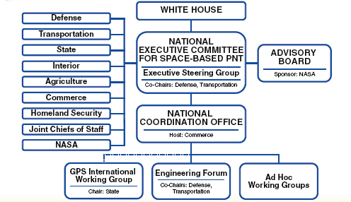
FIGURE 1 U.S. space-based PNT organization structure.
U.S. policy promotes global use of GPS technology:
- No direct user fees for civil GPS services
- Provided on a continuous, worldwide basis
- Open, public signal structures for all civil services
- Promotes equal access for user equipment manufacturing, applications development, and value-added services
- Encourages open, market-driven competition
- Global compatibility and interoperability with GPS
- Service improvements for civil, commercial, and scientific users worldwide
- Protection of radio navigation spectrum from disruption and interference
GPS PROGRAM STATUS
GPS Constellation Status:
• 31 operational satellites (baseline constellation of 24)
— 11 GPS IIA
— 12 GPS IIR
— 7 GPS IIR-M
— 1 GPS IIF
• 3 additional satellites in residual status
• IIF SV-2 scheduled to launch in July 2011
• IIIA SV-1 scheduled to launch in 2014
• Continuously assessing constellation health to determine launch need
• Global GPS civil service performance commitment met continuously since December 1993 (Figure 2)
GPS Modernization: Increasing Space System Capabilities for Increasing Military/Civil User Benefits:
• 2005–2009—GPS IIR(M): 8 satellites in orbit (Lockheed Martin)
— IIA/IIR capabilities plus
— Second civil signal (L2C)
— M-Code (L1M & L2M)
— L5 Demo
— Anti-Jam Flex Power
— 7.5-year design life
• 2010–2014—GPS IIF: 12 satellites with 2 currently in orbit (Boeing)
— IIR(M) capabilities plus
— Third civil signal L5
— Reprogrammable Nav Processer
— Increased accuracy requirement
— 12-year design life
• 2014–2024—GPS III: up to 32 satellites (Lockheed Martin)
— Increased accuracy
— Increased Earth coverage power
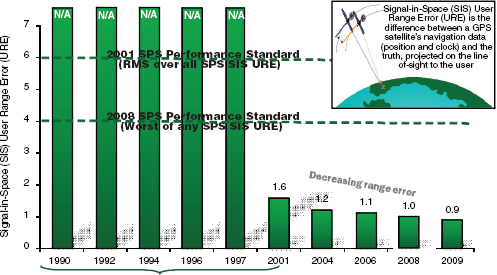
FIGURE 2 GPS signal in space performance (accuracy) far exceeds the published performance standard.
— 15-year design life
— 4th civil signal (L1C)
— Spot Beam for anti jamming (spiral development)
• Operational Control Segment Modernization
— Architecture Evolution Plan (AEP)
o Transitioned in 2007
o Increased worldwide commanding capability
o Increased capacity for monitoring of GPS signals
o Modern distributed system replaced 1970s mainframes
o Current software version (5.5D) enabled SAASM functionality
— Next-Generation Control Segment (OCX)
o Controls more capable constellation and monitors all GPS signals
o $1.5 billion contract awarded February 25, 2010
o Capability delivered incrementally to reduce risk
o On track for Preliminary Design Review in 2011
o Full capability by ~2016
GPS Modernization will result in the following new civil signals:
• Second civil signal (L2C)
— Designed to meet commercial needs
— Higher accuracy through ionospheric correction
— Available since 2005 without data message
— Phased roll-out of CNAV message starting in 2009
— Full capability: 24 satellites ~2016
• Third civil signal (L5)
— Designed to meet demanding requirements for transportation safety-of-life
— Uses highly protected Aeronautical Radio Navigation Service (ARNS) band
— 24 satellites ~2018
• Fourth civil signal (L1C)
— Designed with international partners for interoperability
— Modernized civil signal at L1 frequency
— More robust navigation across a broad range of user applications
— Improved performance in challenged tracking environments
— Original signal retained for backward compatibility
— Specification developed in cooperation with industry recently completed
• Launches with GPS III in 2014
• On 24 satellites by ~2021
GPS Modernization: Semi-codeless Transition:
- GPS receivers attain very high accuracy by using “codeless” or “semi-codeless” techniques that exploit the encrypted military GPS signals without actually decoding them. These techniques will no longer be necessary once the new civil GPS signals are fully operational.
- The U.S. government published a notice for users to transition to GPS civil-coded signals by December 31, 2020, based on the current launch schedule and projected budget. This will provide time for an orderly and systematic transition.
- The U.S. government led community-wide collaboration on this transition plan.
- The United States is committed to continually improving GPS services as users complete a timely transition to dual-coded civil GPS equipment.
AUGMENTATION PROGRAMS STATUS
Wide Area Augmentation System—Phased Upgrades:
• Phase I: Initial Operational Capability (July 2003) Completed
— Provided lateral navigation/vertical navigation/limited localizer performance with vertical guidance (LNAV/VNAV/LPV) capability
• Phase II: Full LPV (FLP) (2003–2008) Completed
— Improved LPV availability in Continental United States (CONUS) and Alaska
— Expanded WAAS coverage to Mexico and Canada
• Phase III: Full LPV-200 Performance (2009–2013)
— Software enhancements, hardware upgrades
— Steady-state operations and maintenance
— Transition to FAA performed second level engineering support
— Begin GPS L5 transition activities
• Phase IV: Dual Frequency (L1,L5) Operations (2013–2028)
— Complete GPS L5 transition
— Will significantly improve availability and continuity during severe solar activity
— Provide additional protection against GPS interference
— Will continue to support single frequency users
Nationwide Differential GPS System (Figure 3):
- Expansion of maritime differential GPS (DGPS) network to cover terrestrial United States
- Built to international standard adopted in 50+ countries

FIGURE 3 Nationwide DGPS network.
• Operated/managed by U.S. Coast Guard as a Combined NDGPS (Maritime + Department of Transportation sites + ACOE sites)
• System Specifications
— Corrections broadcast at 285 and 325 kHz using minimum shift keying (MSK) modulation
— Real-time differential GPS corrections provided in Radio Technical Commission for Maritime Services (RTCM) SC-104 format
— No data encryption
— Real-time differential corrections for mobile and static applications
— Single coverage terrestrial over 92 percent of CONUS; double coverage over 65 percent of CONUS
National Continuously Operating Reference Stations (CORS) (Figure 4):
• Enables highly accurate, 3-D positioning
— Centimeter-level precision
— Tied to National Spatial Reference System
• 1,200+ sites operated by 200+ public, private, academic organizations
• National Oceanographic and Atmospheric Administration’s (NOAA) Online Positioning User Service (OPUS) automatically processes coordinates submitted via the web from around the world
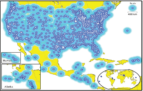
FIGURE 4 CORS network.
- OPUS-RS (Rapid Static) declared operational in 2007
- NOAA considering support for real-time networks
INTERNATIONAL COOPERATION ACTIVITIES
Excerpts from U.S. Space-Based PNT Policy focused on international relations:
- Goals include maintaining U.S. space-based PNT systems and services as essential components of internationally accepted PNT services, and promoting U.S. technological leadership in applications involving space-based PNT services.
- To achieve this, the U.S. government shall: encourage foreign development of PNT services/systems based on GPS; seek to ensure foreign space-based PNT systems are interoperable with civil GPS and augmentations; and, at a minimum, ensure compatibility.
- The Secretary of State shall promote the use of civil aspects of GPS and its augmentation services and standards with foreign governments and other international organizations, and lead negotiations with foreign governments and international organizations regarding civil PNT matters.
U.S. objectives in working with other GNSS service providers include:
- Ensuring compatibility, defined as the ability of U.S. and non-U.S. space-based PNT services to be used separately or together without interfering with each individual service or signal, involving both radio frequency compatibility and spectral separation between M-code and other signals.
- Achieving interoperability, defined as the ability of civil U.S. and non-U.S. space-based PNT services to be used together to provide the user better capabilities than would be achieved by relying solely on one service or signal, with the primary focus on the common L1C and L5 signals.
- Ensure a level playing field in the global marketplace.
U.S. GNSS international objectives are pursued through bilateral and multilateral cooperation as follows:
• U.S.-EU GPS-Galileo Cooperation Agreement signed in June 2004
— Four working groups set up under the Agreement
• U.S.-Japan Joint Statement on GPS Cooperation 1998
— Quasi-Zenith Satellite System (QZSS) designed to be fully compatible and highly interoperable with GPS
— Bilateral agreements to set up QZSS monitoring stations in Hawaii and Guam
• U.S.-Russia Joint Statement issued December 2004
— Working Groups on navigation signal compatibility and interoperability, and search and rescue service
• U.S.-China operator-to-operator coordination meetings held under ITU auspices in:
— Geneva, Switzerland - June 2007
— Xian, China - May 2008
— Geneva, Switzerland - October 2008
— Hainan, China - December 2009
— Coordination completed in Chengdu, China, in September 2010
— The United States is interested in engaging in further bilateral discussions with China on civil GNSS services and applications
• U.S.-India Joint Statement on GNSS Cooperation 2007
— Technical Meetings focused on GPS-India Regional Navigation Satellite System (IRNSS) compatibility and interoperability held in 2008 and 2009
— Continuation of ITU compatibility coordination is pending
• U.S.-Australia Joint Delegation Statement on Cooperation in the Civil Use of GPS in 2007
— Bilateral meeting in Washington, D.C., October 26–27, 2010
— GNSS and applications to be included in expanded space cooperation, as discussed in an October 27 Joint Announcement
International Committee on GNSS:
• Emerged from Third UN Conference on the Exploration and Peaceful Uses of Outer Space July 1999
— Promote the use of GNSS and its integration into infrastructures, particularly in developing countries
— Encourage compatibility and interoperability among global and regional systems
• Members include:
— GNSS providers (United States, European Union, Russia, China, India, Japan)
— Other Member States of the United Nations
— International organizations/associations
• Providers Forum
— Six space segment providers are members
— Purpose:
o Focused discussions on compatibility and interoperability, encouraging development of complementary systems
o Exchange detailed information on systems and service provision plans
o Exchange views on ICG work plan and activities
— Providers have agreed that all GNSS signals and services must be compatible, and open signals and services should also be interoperable to the maximum extent possible
— Working definition of compatibility includes respect for spectral separation between each system’s authorized service signals and other systems’ signals
— Interoperability definition addresses signal, geodetic reference frame realization, and system time steerage considerations
APEC (Asia-Pacific Economic Cooperation) GNSS Implementation Team
- GNSS Implementation Team (GIT) established in 2002
- Mission—Promote implementation of regional GNSS augmentation systems to enhance inter-modal transportation and recommend actions to be considered in the Asia Pacific Region
- Reports to Transportation Working Group through the Inter-modal Experts Group
- Adopted a GNSS Strategy designed to promote adoption of GNSS technologies throughout the Asia Pacific region, especially with regard to transportation
CONCLUSION
• GPS performance is better than ever and will continue to improve
— Augmentations enable even higher performance
— New civil GPS signal available now
— Many additional upgrades scheduled
• U.S. policy encourages worldwide use of civil GPS and augmentations
• International cooperation is a priority
• In pursuit of systems compatible and interoperable with GPS


