Review of the Inland Estimated Recovery System Potential (ERSP) Prototype Calculator (2022)
Chapter: Appendix C: Potential Improvements to the USCG Inland ERSP Calculator
Appendix C
Potential Improvements to the USCG Inland ERSP Calculator
As written in Recommendation 4.2, “If the intent of the calculator is to predict potential recovery under a specific scenario and potentially a geographic location, the calculator should more accurately reflect the location and scenario-specific details of oil fate and behavior.” The current version of the USCG Inland ERSP Calculator lacks the ability to address details about specific locations of interest and their attributes. This has been done to minimize the complexity of the tool and to facilitate its use by those with limited experience. Unfortunately, this also limits the utility of the calculator for those with more experience and interest in gaining additional insight into spill response in particular areas.
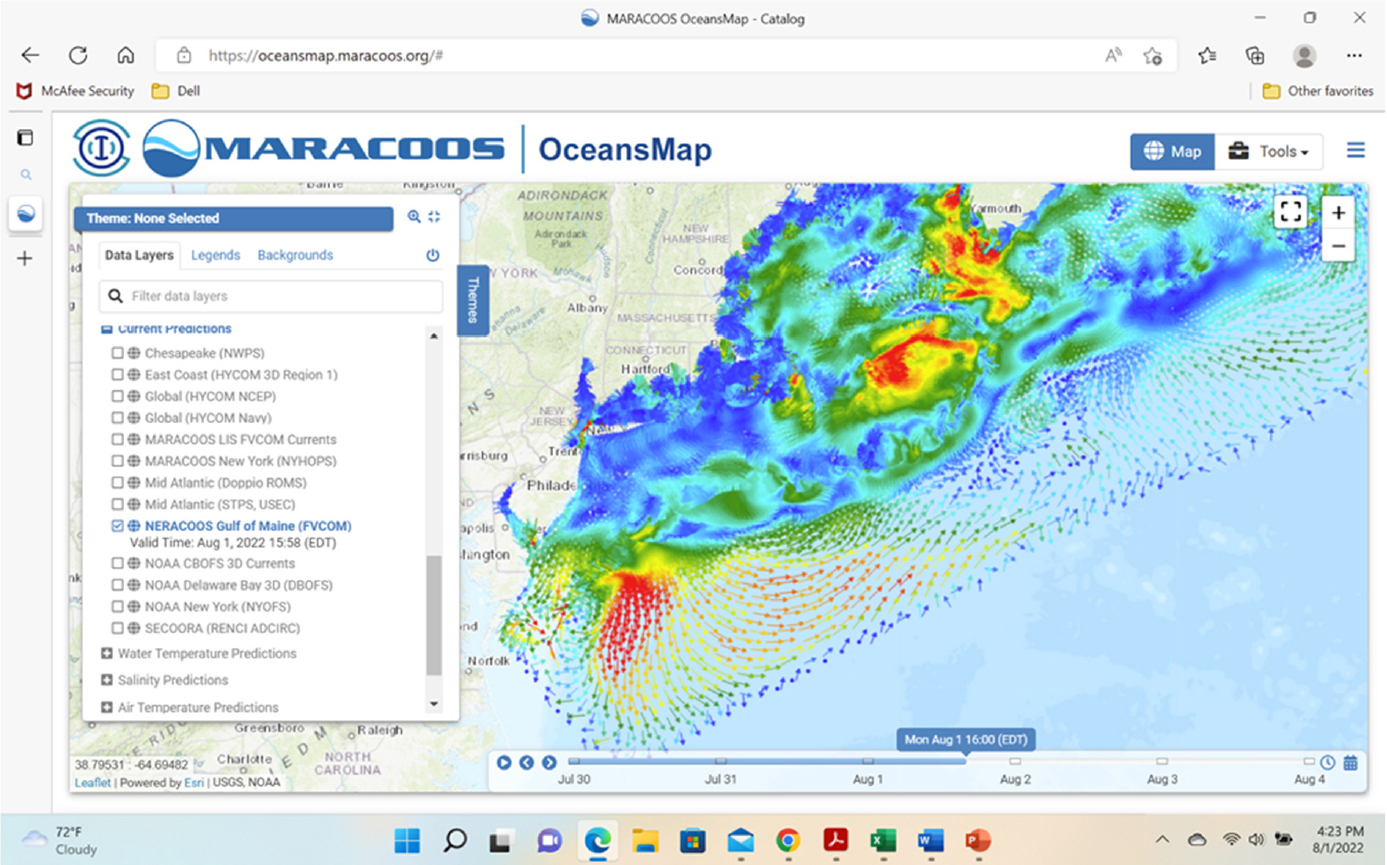
It is suggested that the USCG consider developing a more inclusive calculator that allows the user to readily apply it to specific geographic locations. As envisioned, the user will select the area of interest using a topographic (digital elevation) map. The area of focus could be a river/stream or lake/pond. Once selected, the interface would provide the user with a summary of the databases that are available to provide information on the stream flow or waterbody and its characteristics. The USCG might achieve this goal by enhancing the database used to support SAROPS (Search and Rescue Optimal Planning System)1 or accessing data from the Integrated Ocean Observing System (IOOS)2 community. As an example, Figure C.1 shows the current data that is available via OceansMap, which is operated on behalf of MARACOOS (Mid Atlantic Regional Association for Coastal Ocean Observing).3 There are IOOS regional associations covering the entire coast of the U.S., including Alaska. The IOOS coverage often includes major rivers up to the head of the tide and has multiple models from which the user can select (see insert in Figure C.1 below, left side).
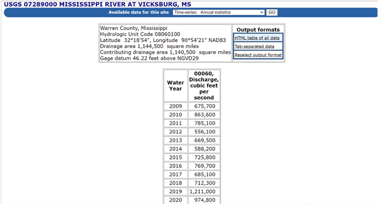
For inland areas, the U.S. Geological Survey (USGS) has developed a countrywide monitoring network to observe flows in rivers and streams with over 13,000 stations. Figure C.2 (upper panel) shows the location of the observation stations, color coded by stream flow rate from the USGS National Water Dashboard.4 An interrogation tool (lower panel) allows the user to determine the flow rate for the most recent observation, in this case on the Mississippi River at Vicksburg, MS. The user can also follow links to find a summary of prior observations and associated statistics. As an example, Figure C.3 shows the mean flow values from 2009 to 2020.
The flow rate data needs to be converted into flow speed for it to be used in the USCG Inland ERSP model. To do that, one can ideally rely on the underlying topographic observations used by the USGS. As an alternative for streams that are not well documented, one could use an approximate method such as that developed by Andreadis et al. (2013), which estimates channel width and depth using empirical equations based on an analysis of global stream characteristics using satellite imagery. With the channel dimensions, one can determine channel flow speed. Assuming a limited area of application data from the various sources noted above, the model could apply simple conservation of water mass principles to determine the flow fields in the area of interest. This information can then be used directly as input to the USCG Inland ERSP model to help provide locally specific data.
___________________
1 See https://www.dcms.uscg.mil/Our-Organization/Assistant-Commandant-for-Acquisitions-CG-9/International-Acquisition/sarops/; accessed 9 August 2022.
2 See https://ioos.noaa.gov/; accessed 9 August 2022.
3 See https://oceansmap.maracoos.org/; accessed 9 August 2022.
4 See https://dashboard.waterdata.usgs.gov/app/nwd/?aoi=default; accessed 9 August 2022.


As an alternative to using the current version of the USCG Inland ERSP Calculator, an oil spill model could be applied locally using input from the above flow model and specifications of the spill release rate, duration, and oil type to predict the oil spill transport and fate. The model would provide predictions of the oil mass balance, and thickness and size of the slick, as a function of time since release for a user
defined spill release and oil type. This could include oil by typical classes or the detailed characteristic of a particular oil of interest. The user could also specify the shoreline type for the area of interest. Predictions of the spill model would be adjusted by the removal of oil from the environment by booming and skimming operations, as is currently done in the USCG Inland ERSP Calculator. If a more rigorous analysis is required, then the SLICKMAP model, funded by U.S. Department of Transportation and Minerals Management Service (now the Bureau of Ocean Energy Management, Regulation, and Enforcement), could be used (Grilli et al., 1996a, b; 1997; 2000). SLICKMAP predicts the detailed behavior of the dynamics of oil containment by booms and has been extensively verified by laboratory scale studies.
REFERENCES
Andreadis, K. A., G. J.-P. Schumann, and T. Pavelsky. 2013. A simple global riverbank full width and depth database, Water Resources Res., 49, 7164–7168, doi:10.1002/wrcr.20440.
Grilli, S. T., Z. Hu, and M. L. Spaulding. 1996a. A Hydrodynamic Model of Oil Containment by a Boom: Phase I. Final Technical Report. DOT Grant No. DTRS57-94-G-00076, Washington, DC: U.S. Department of Transportation.
Grilli, S. T., Z. Hu, and M. L. Spaulding. 1996b. Numerical modeling of oil containment by a boom. In Proc. 19th Arctic and Marine Oilspill Program Tech. Seminar (Arctic and Marine Oilspill Program, Calgary, Alberta), pp. 343–376. Environment Canada.
Grilli, S. T., Z. Hu, M. L. Spaulding, and D. Liang, 1997. Numerical Modeling of Oil Containment by a Boom/Barrier System: Phase II. Final Technical Report. Washington, DC: Department of Transportation.
Grilli, S. T., T. Fake, and M. L. Spaulding, 2000. Numerical Modeling of Oil Containment by a Boom/Barrier System: Phase III. Final Technical Report. Washington, DC: Department of Transportation.


