Developing a Guide for Truck Parking Information Management Systems (2025)
Chapter: 3 TPIMS Practices
CHAPTER 3
TPIMS Practices
This section provides a summary of current TPIMS practices utilizing the findings of the information review. It fuses the various topics in the literature review, research efforts, surveys on parking preferences, insights on hardware/software/technology, and real-world TPIMS deployments. Furthermore, this section identifies new and existing practices that were investigated as part of the development of reference material for transportation agencies looking to embark on a TPIMS effort.
The remainder of this section of the report is organized as follows:
- Understanding of TPIMS practices. This section outlines the need for TPIMS, the challenges of why TPIMS is not easily implemented, and broader considerations associated with TPIMS practice.
- Policy and planning for TPIMS. This section highlights policy considerations, business models, and coverage types and the situations in which they would be relevant. This section also covered parking lot types that should be considered with TPIMS, parking preferences of truck drivers and why those preferences are important for TPIMS placement, identifying stakeholders, and establishing system requirements.
- Selection of a TPIMS count methodology. This section discusses various methodologies for assessing parking availability, and the set of advantages, disadvantages, and applicable roles.
- Technology options associated with information collection. This section touches on various technologies that are relevant for both public-sector and private-sector TPIMS. Each technology has its own set of advantages and disadvantages that should be considered when designing, operating, and maintaining TPIMS.
- Technology options associated with information processing. This section discusses on various technologies and operating models that are relevant for both public-sector and private-sector TPIMS. Each technology model has its own set of advantages and disadvantages that should be considered when designing, operating, and maintaining TPIMS.
- Technology options associated with information distribution. This section touches on various technologies that are relevant for pushing information out to truck drivers (and their affiliated stakeholders, such as dispatchers). Each technology model has its own set of advantages and disadvantages that should be considered when designing, operating, and maintaining TPIMS.
Understanding of TPIMS Practices
TPIMS practices involve myriad considerations, practices, and decisions. The technology itself—while evolving—is not new. Parking availability systems have existed for decades in other applications—specifically, parking garages at airports, shopping malls, and stadiums—and these systems have demonstrated an ability to successfully inform customers of available parking in a crowded facility. A logical step would be to move parking management systems into other forums, specifically to help resolve truck parking issues, but despite efforts undertaken by several organizations, the concept is far from boilerplate.
In order to understand the practice, one has to first understand the challenges facing transportation agencies, such as:
- Each transportation agency has different ITS standards. TPIMS, in the public sector, is often introduced as part of a transportation agency’s ITS program. ITS staff generally have their preferred sensor type (e.g., microwave radar, loop detector, etc.) that aligns with their program, which is often tied to maintenance and operating software requirements. This influences how trucks can be detected and how the system maintains count accuracy. Additionally, transportation agencies with power and communication requirements (e.g., wired vs. wireless) influence where devices can be placed and which parking lots are considered feasible for TPIMS; these specific power and communication requirements also impact the long-term maintenance costs of TPIMS.
- Each transportation agency has different parking lot designs. Some transportation agencies have traditional rest area designs with truck parking separate from general passenger vehicle traffic. Others have mixed-use parking. When the private sector participates, their requirements may be different from transportation agencies. Additionally, some parking lots may use marked parking stalls, whereas others may be unmarked and have greater flexibility on where parking occurs. This influences which equipment is selected for detecting trucks.
- Each transportation agency has different policies as well as procurement models. Nearly all transportation agencies in the United States utilize the traditional design-bid-build procurement model, which is great for civil construction, but not ideal for technology programs which emphasize adherence to system requirements as opposed to specific designs or technologies. Some of the States do not allow design-build construction. Some may do design-build, but not system integration contracts (generally preferred for technology programs in the industry). Some States have restrictive data sharing requirements, inhibiting regional data exchange.
- Transportation agencies are generally not in the parking operations business and lack first-hand design experience. State transportation agencies may build truck parking lots using design standards, but historically have not been in the business of monitoring real-time parking utilization. Most ITS and Transportation System Management and Operations (TSMO) programs focus only on roadway traffic operations and not parking. As a result, transportation agencies usually do not have in-house staff that are familiar with the needs and requirements for building a real-time parking availability system, and local consulting firms may be equally unfamiliar with how to guide the concept into design.
- Some private-sector truck parking options operate their own systems. Private-sector truck stops offer truck parking and may provide information regarding availability, but these systems tend to operate in their own ecosystem and are not often in coordination with public-sector efforts, which include groups who oversee the road operations. Additionally, they may be incentivized against reporting low availability that might discourage potential customers and may utilize for-profit reservation systems as part of their parking system.
Transportation agencies are often tasked with identifying improvements for truck parking. When considering TPIMS as an application, there are various considerations for the practice. TPIMS, being a system of subsystems, follows closely to the development practices associated with an ITS program. In the United States, FHWA recommends designing and deploying such systems by using the systems engineering approach, which is a structured process for defining the problem, identifying needs and requirements, and ultimately implementing a system that meets user needs. When Federal funds are involved, Part 940 of the Code of Federal Regulations (CFR 940) requires that this approach be followed. In the ITS community, systems engineering typically uses what is referred to as the V-diagram, shown in Figure 1.
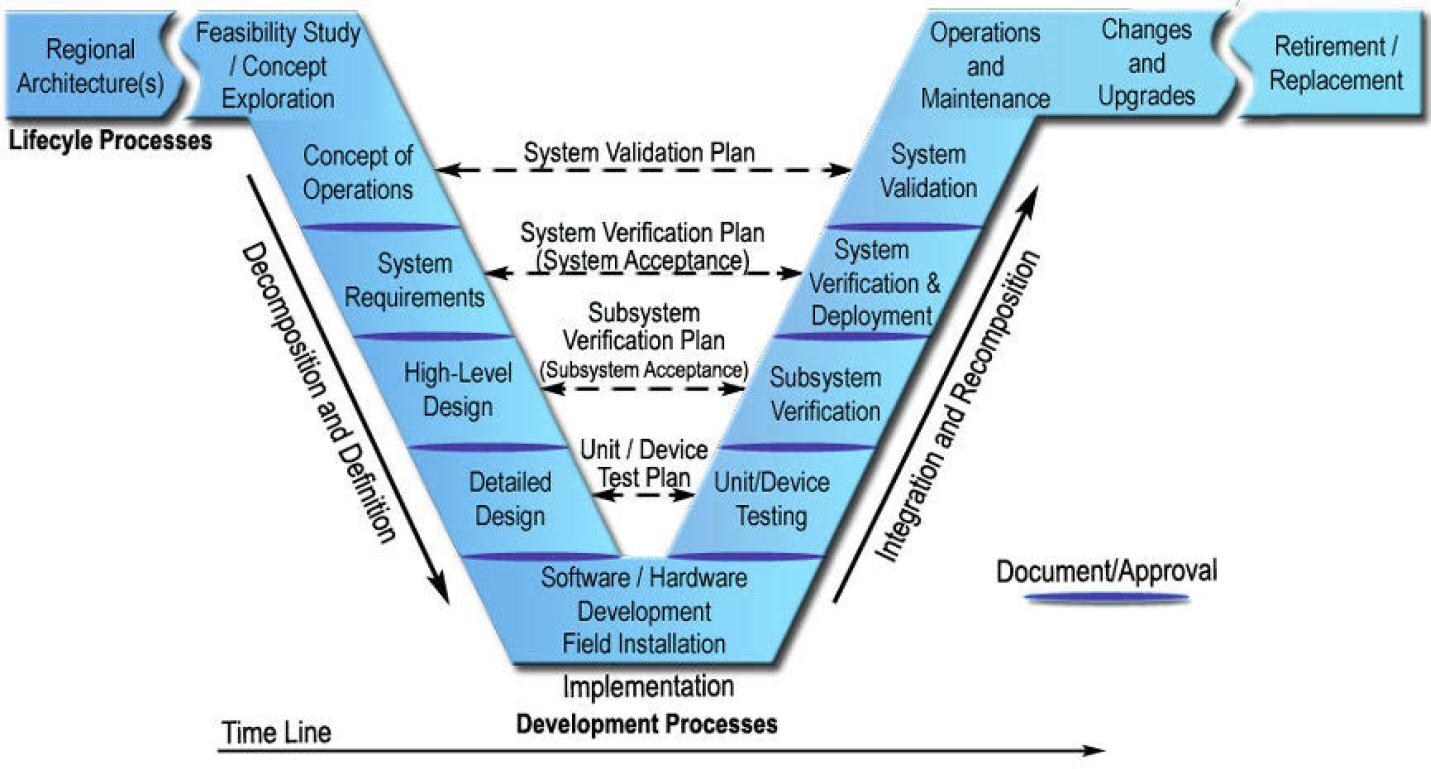
Figure 1. Systems engineering V-diagram.
The V-diagram outlines considerations that must be done throughout the lifecycle of TPIMS, ranging from the policy, planning, deployment, ongoing operations and maintenance, and eventually retirement. Among the documents that are prepared as part of this approach, the V-diagram touches on certain key areas that are relevant to the practice, including validation and verification processes.
- Identifying the purpose and need for TPIMS—This is often addressed by understanding the placement and role of TPIMS among a transportation program, and its feasibility in this program.
- Planning TPIMS—Building off the policy considerations, planning for TPIMS is addressed by assembling Concept of Operations and System Requirements documents. It delves into some of the planning-level considerations and requirements necessary to meet user needs.
- Designing TPIMS—With planning-level decisions made, designing for TPIMS involves the preparation of plans and other procurement documents. Following the system requirements identified as part of planning, various technologies must be identified to meet those requirements. Similarly, options may exist for some other service level agreement of how the system should perform.
- Procuring and deploying TPIMS—With design complete, the next step is to procure and deploy TPIMS. This includes the necessary testing to make sure the deployed system meets the design specifications, including tests at both the subsystem and system level. While the testing is not discussed in detail within this practice identification, it is an important consideration when factoring what options might be available to TPIMS deployers. Validation also confirms that the goals and objectives defined during the Concept of Operations are met; in other words, while the system may function as designed, does it meet the intent of the purpose and need?
- Operating and maintaining TPIMS—With the system being activated, TPIMS must be operated and maintained. Although this is one of the last steps in the process, it is the part of the process that is most greatly impacted by decisions made in the planning, design, and deployment phases. Thus, understanding the implications of various decisions made in previous stages can inform a TPIMS deployer on what they are committing themselves to.
The above practice outline follows closely to the traditional public-sector model for project development. In reality, TPIMS is both a public-sector and private-sector venture. Private-sector deployment groups may have different motivations for TPIMS and follow different processes for project development. Therefore, in the following section that outlines the practice, both groups and their affiliated methods are represented as participants in possible truck parking information systems in a region.
Policy and Planning for TPIMS
Public policy regarding truck parking can be structured around various economic, social, and political factors. Certain organizational policies will need to be developed and implemented in order for TPIMS to be a success. Additionally, TPIMS may be impacted by local zoning and land use policies, so reviewing and understanding those policies will be key to determining if a proposed TPIMS deployment comes in conflict with existing requirements. The key policy considerations surrounding TPIMS are summarized in Table 14.
Table 14. TPIMS policy considerations.
| Policy Consideration | Summary |
|---|---|
| Zoning and Land Use Requirements | Zoning and land use drives the location of truck parking capacity. Furthermore, zoning and land use decisions are made at the local Government level with local interests in mind. Because of this, verify if publishing real-time availability interferes with existing ordinances such as limited hours of operation. |
| Revenue and Cost Share Models | Commercial activities within the Interstate right-of-way are prohibited under 23 U.S.C. § 111(b) which prevents the sale of goods and services at rest areas and other DOT facilities. While agencies are prohibited from revenue models that involve pay-per-space or reservation fees, agencies could offset costs for implementing a parking model through sponsorships (e.g., “blue sign” sponsors on highways including hotels, restaurants, etc.). Or they may use public-private partnerships where the public sector maintains technology and equipment and the private-sector offsets costs through subscriptions or fees. |
| Safety Policies for Mobile Communications | When considering the introduction of mobile technology, safety and limiting driver distraction are paramount concerns. The FMCSA restricts commercial vehicle drivers from texting or even using a hand-held mobile device while driving (49 CFR § 392.80 and 49 CFR § 392.82). As a result, mobile applications developed as part of a TPIMS must require either the vehicle to be parked or have a hands-free, voice-only command option. |
| Policy Consideration | Summary |
|---|---|
| Data Accuracy Policies |
TPIMS that provides incorrect or outdated parking availability will quickly lose credibility. Many public agencies have implemented policies for how, when, and under what conditions information can be posted and how the posted information should be verified for other ITS devices. However, existing policies for those devices may need to be reevaluated for TPIMS, as truck drivers may be more sensitive to inaccurate parking information compared to other roadway users. Some factors to consider include:
|
| Stakeholders and Engagement | Involving stakeholders in the TPIMS development process is critical for its success. Part of the policy considerations should include identifying the types of stakeholders—those directly involved and indirectly involved. These groups are valuable for providing the necessary insights on what TPIMS would work best for a particular region. |
TPIMS Business Models
Several business models for deploying TPIMS exist. Prior to embarking on a TPIMS effort, first evaluate which business model might be most appropriate. A public-sector agency may have certain requirements for how TPIMS can be procured, operated, and maintained, whereas a private-sector group may have greater flexibility and fewer institutional barriers. In general, both the public sector and private sector can either have distinct owner and/or operator responsibilities over the entire TPIMS system, or they can both participate in a partnership.
- Publicly Owned Land/Lots Investing in TPIMS. In this business model, a public agency may own a parcel of land and wish to construct, operate, and maintain a new truck parking facility equipped with TPIMS on the site. For an existing facility, an agency may elect to deploy TPIMS through their ITS program and involve others to help inform the parking availability.
- Publicly Owned Land/Lots Partnering with Private-Sector. In this business model, a public agency may own a parcel of land and wish to construct, operate, and maintain a truck parking facility on the site. A private technology partner could provide a range of support services (e.g., installing and operating a TPIMS, develop and operate a reservation system, etc.), and may provide the capital to implement and operate the system, receiving compensation through a revenue-sharing agreement or ongoing service fee.
- Privately Owned Land/Lots Partnering with Public-Sector Program. In this business model, a private-sector group may own a parcel of land used for parking but wish to see greater utilization of that facility. In order to increase awareness, they opt to partner with the local public agency (usually one with an existing TPIMS program) to provide real-time availability for that lot. Either the public-sector or private-sector equipment may be used to determine availability, so long as a minimum service level of accuracy is maintained for the public agency’s TPIMS program.
- Privately Owned Land/Lots Partnering with Other Private-Sector Groups. In this business model, private-sector organizations own the parking infrastructure and (together or separately) own technology services. Examples of this include reservation-based systems and systems that connect truck drivers with parking providers. In such examples, the private-sector property owner uses a service to notify drivers of available space, the amenities offered on site, and the fee they wish to charge. The truck driver uses an app that is subscribed to a private-sector service to locate and pay for parking. The entire system functions within the app, without the need for a public partner.
TPIMS Coverage Types
Truck parking can be driven by myriad reasons, depending on the type of freight, proximity to origins or destinations, and driver preferences in a given area. Understanding the purpose and need of various trips and parking requirements can identify which parking lots would benefit most from a TPIMS investment. There are the two types of TPIMS coverage that are most prevalent: corridor coverage and strategic coverage.
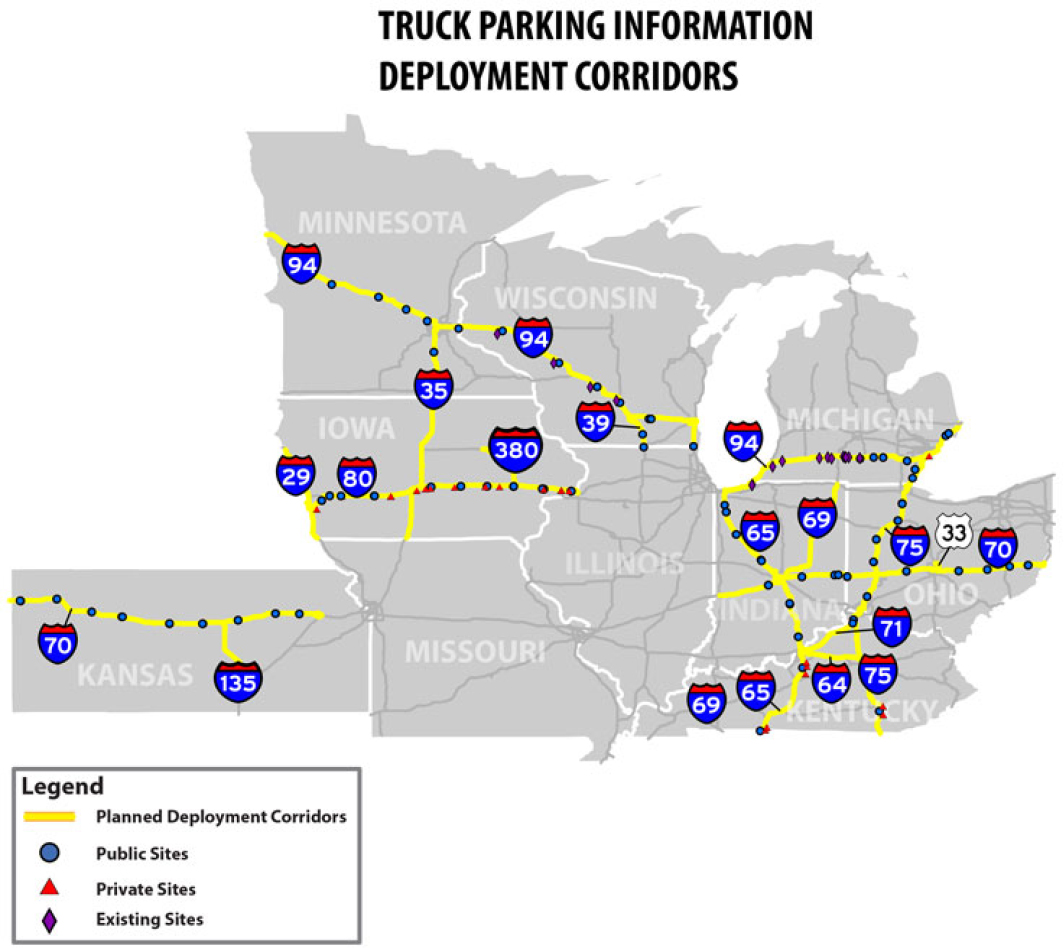
- Corridor Coverage. Corridor coverage represents the rest areas, private-sector truck stops, and any other parking area type (e.g., weigh stations, park-and-ride, etc.) that serve mid-haul or long-haul trucking operations. It serves truck drivers who most likely will need to stop and park at some point far from their origin or destination in order to meet their HOS requirements. Corridor coverage represents most of the TPIMS deployments done to date. Figure 2 provides an example of TPIMS providing corridor coverage.
- Strategic Coverage. This type of coverage represents parking locations that are close to a truck driver’s destination and may serve either as a short-term staging lot or as a longer-term parking lot to meet either an HOS requirement or accommodate a delivery that is booked via appointment several hours later. Strategic coverage would generally include lots that are near intermodal facilities, major logistical distribution centers, and other freight hubs where truck drivers need to coordinate their arrivals. It can also include truck parking for trucks that are not in service, which is a use case that exists in certain metropolitan areas. Figure 3 provides a graphic of some use cases where a truck driver would seek out strategic parking coverage.

Truck Parking Facility Types
Understanding the types of parking facilities can help determine the proposed approach for a TPIMS investment. While truck stops and public rest areas are among the types of lots that come to mind when imagining truck parking, other lot types exist that are both relevant for parking and have demonstrated use cases of being an extension of TPIMS. The following subsections outline four types of parking sites that could be considered for TPIMS.
Traditional Public-Sector Rest Areas, Weigh Stations, Welcome Centers, and Truck Parking Lots
Rest areas, weigh stations, welcome centers, and truck parking lots are among the most common truck parking facilities that public-sector transportation agencies provide. Rest areas and welcome centers are present along major Interstate and other highway corridors at frequent intervals and can be found in other forms such as waysides or other points of interest. Some agencies have implemented truck-only parking lots, which are often in locations where truck traffic volumes are high; these lots sometimes have amenities, although often fewer than traditional rest areas. Some agencies allow parking at weigh stations and park- and-ride lots as well. In most instances of public-sector TPIMS, this type of parking lot is included.
Private-Sector Truck Stops and Truck Parking Lots
Truck stops are the most common truck parking facilities offered by the private sector. They make up the vast majority of available truck parking and are often the preferred parking location among long-haul truckers due to the amenities (e.g., showers, bathrooms, restaurants/food, Wi-Fi, etc.) offered at these sites. While these are for-profit entities, most truck stops offer free parking to trucks for some duration, as the truck stop benefits by having paying customers visit their various services. Many fleet trucking companies have usage agreements with truck stop facility owners, allowing their truck drivers to receive discounted fuel rates and reduced costs for stopping at their facility. TPIMS is far less common at private-sector truck stops; while many of these establishments desire the advertising of parking availability, there is some industry reluctance to acknowledge that the parking lot is completely full and potentially turn away customers.
Mixed-Use Truck Parking Lots
The concept of incorporating mixed-use lots into TPIMS is analogous to the Airbnb or Vrbo business model as it would match parking providers with truck drivers through an online marketplace. This is an emerging practice in truck parking based on the idea other parking facilities (i.e., not dedicated to truck parking) can be managed to provide truck parking on an intermittent basis. Some examples of this include professional sports stadium or music venue complexes (which have parking availability during periods when no event is occurring), retail centers (which have parking availability during off-periods), and publicly owned facilities such as farmers markets and fairgrounds (which have parking availability during periods when no event is occurring). Providing information on when and where these parking spaces are available is a strategy to provide real-time parking availability.
Curb Space Truck Parking
Curbside management is an element of truck parking that includes its own myriad challenges and requirements. While curb operations focus more on short-term parking activities, such as loading and unloading, it can also be used in staging operations, such as trucks parking in curb areas near major intermodal or logistical centers in advance of a delivery window. Curb parking is an equal consideration to the context of regional truck parking, but it historically has had limited technology deployed in comparison
to its peers. Curb management parking information systems leverage mobile technologies to direct truck drivers to available curb spaces in urban settings. They allow for curb spaces in commercial or industrial areas to be dynamically used throughout the day and week based on time of day and duration of parking; additionally, this approach has the potential to create non-traditional truck parking zones on the fly. Curb management parking information systems offer similar benefits to traditional TPIMS architectures by providing truck drivers with parking availability to make informed decisions in this specific (but prevalent) use case, helping to reduce circulation time.
Truck Driver Parking Preferences
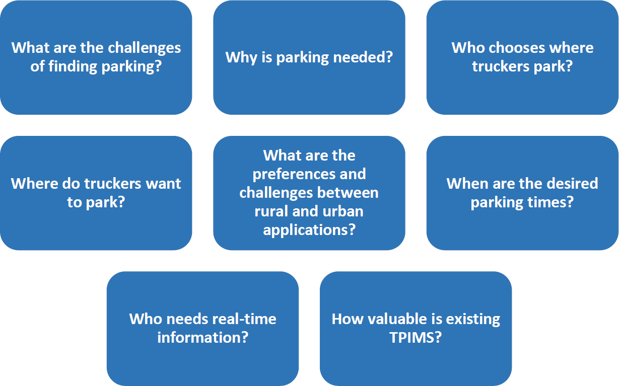
Understanding truck driver parking preferences is a fundamental part of the policy and planning process. Truck drivers are looking to maximize the value of their trip, all while meeting regulatory requirements and maintaining a comfortable quality of life. While this topic area is often thought of being more relevant to the actual investment in truck parking capacity, it includes a wealth of insights on parking preferences that can influence where and how TPIMS investments may succeed, especially when considering that limited investment budgets may require choosing one TPIMS investment over another.
Key questions related to truck parking preferences that are useful for the development of a TPIMS include those presented in Figure 4. These questions will likely have different answers among different truck driver populations and trucking company types, and the answers may vary greatly among the same population when factoring in different trip types and geographic regions. Efforts taken to address these policy and planning challenges will be extremely useful in informing the type of TPIMS that provides an agency the greatest value.
System Requirements
The TPIMS program is intended to provide reliable, real-time information to truckers so that they can make informed decisions regarding parking that aligns with their HOS requirements. Since TPIMS utilizes
technology processes, the general framework for a successful program follows the requirements for a successful ITS program. As shown in Figure 5, this includes 1.) a means to collect data, 2.) a means to process the data, and 3.) a means to distribute that data to the targeted user group.

Although the process is straightforward, the means and methods of conducting these requirements can vary widely. Several strategies exist for assessing and distributing the number of available parking spaces, and many different technologies can be utilized for a particular strategy. Planning efforts must ensure that all three of these facets are properly captured and understand that each facet has its own complex considerations, opportunities, and drawbacks.
Selecting a Parking Availability Assessment Methodology
Truck parking availability information must be collected efficiently, accurately, and on time. Many ways exist to collect data from truck parking areas to accurately reflect their occupancy. However, they all must be adaptable to the constraints each individual site provides. There are four primary methods for assessing parking availability:
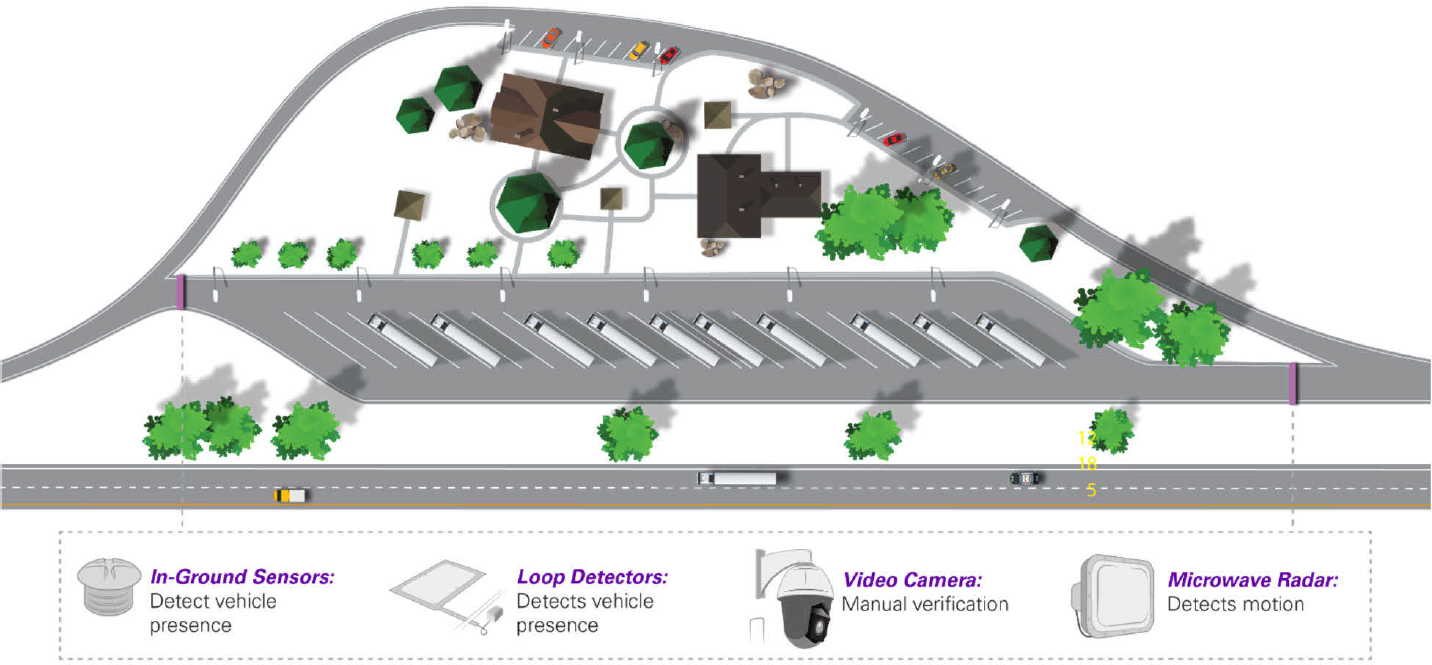
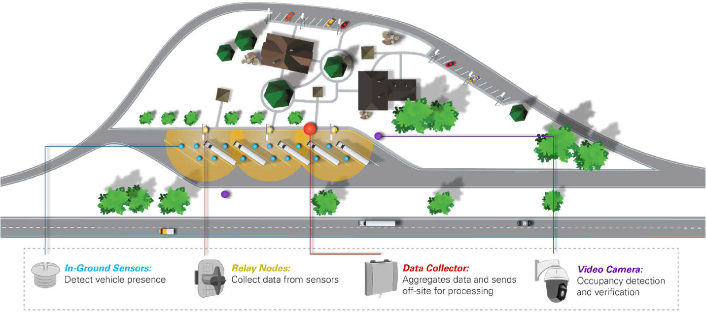
- Entrance/Exit Count Method. This method counts all vehicles as they drive in and out of the parking lot and applies the following logic: every vehicle that enters the lot counts as one less available parking space, and each vehicle that exits the lot counts as one additional available space (see Figure 6). The entrance/exit count method is ideal for parking lots with clearly defined entrances and exits and lots that have a total parking capacity that is greater than the number of individually marked spaces (such as informal spaces in rest areas). The entrance/exit count methodology is generally a more cost-effective option from a capital investment perspective; however, it also has a higher probability of error which can result in higher operational costs (e.g., from ongoing manual adjustments). When a truck is miscounted or misclassified by the detection technology, a truck occupies multiple spaces, or a passenger vehicle occupies a truck space, the method produces errors that will continue to propagate until manually corrected. As a result, transportation agencies must frequently verify whether the system is accurately reporting parking availability which can produce high operational expenses associated with this method.
- Space Occupancy Count Method. The space occupancy count method detects the presence of vehicles within predefined areas and determines availability based on the number of unused spaces (see Figure 7). Overall, this method has been found to provide the most accurate assessment of parking availability. The method is self-correcting in that if a detection device does not recognize a truck occupying a space, it will detect the truck once it departs. However, a drawback to the space occupancy count method is that any maintenance activity—such as milling and resurfacing, adding a topcoat, or even repainting of markings—may require additional time and effort to adjust the system to reflect changes or replace components. The space occupancy count method works best in parking facilities with marked parking stalls and good compliance of parking within those stalls.
- Digital Occupancy Count Method. The digital occupancy count method may be applied at parking facilities with a reservation system. When using this method, the TPIMS data collection technology determines availability based on the number of “check-ins” or “reservations,” either for an individual parking spot (similar to space occupancy count method) or for a parking lot in general (similar to entrance/exit count method). Unlike the real-time monitoring systems, this digital occupancy count method evaluates parking availability on a temporal basis, as reservations can be made into the future.
- For example, a parking lot with a reservation system may be completely empty of trucks, but a truck driver attempting to make a reservation an hour later may be told that there is no availability due to existing reservations that have been made for that timeframe.
- Crowdsourcing Count Method. The crowdsourcing count method passes along word-of-mouth information collected about whether a given parking lot has availability for truck parking. This is often done through mobile applications that provide truck drivers with the ability to report parking availability. Rather than seek out an actual count, many of these crowdsourcing applications ask reporters to provide observations on parking that are a tiered approach; for example, reporting “Many Available Parking Spots” to “Some Spots” to “Lot is Full.” Both parking lot owner/operators and truck drivers themselves can contribute information, which increases the reach of this data.
The selection of a count method is often one of the most critical decisions for a TPIMS provider to decide, as its selection will dictate a menu of capital, operations, and maintenance costs necessary to achieve a certain level of accuracy. Understanding this key decision helps inform planning and design phases.
Technologies for Information Collection
For a TPIMS to function, real-time data on parking availability must be collected from the parking lots themselves, using one of the count methods described in the section above. As discussed in the TPIMS Information Review on technology hardware, and software associated with TPIMS, many types of monitoring technologies are available. This section identifies technologies that are frequently used to determine real-time parking availability and the various count methods for which they are relevant. This list is not exhaustive, given the ever-evolving applications of technology to monitor truck parking.
Magnetometer. In-pavement magnetometer sensors detect changes in the surrounding magnetic field caused by ferrous metal objects. For entrance/exit count applications, a magnetometer senses when a vehicle passes over and counts the vehicle as it enters or exits the lot. Similarly, for space occupancy count applications a magnetometer senses when a vehicle occupies a space and counts the vehicle as it enters or exits that space. The magnetometer is calibrated to determine when the vehicle has passed and resets the reference magnetic field to wait for a change, indicating a new vehicle has passed over the sensor. Most magnetometer sensors are wireless and require minimal effort to install. Magnetometer sensors are a proven technology and are reliable and inexpensive compared to some other counting technologies. Battery life for these sensors has been identified as a challenge. Additionally, in space occupancy applications if a truck that is adjacent to other parking spot parks too close to the sensor, the magnetometer in that other space may detect a change in the magnetic field and incorrectly report the space as occupied, essentially reporting that two parking spaces are occupied.
Video Detection. Video detection technology uses video cameras paired with video analytical algorithms to determine parking availability. Most commercial off-the-shelf products made for traffic detection employ a predefined zone-based or trip-line detection method, but advances in video analytics are rapidly being enhanced to use object recognition and tracking to accurately count and classify vehicles in non-ideal conditions, such as slow or stopped speeds, bi-directional traffic, and undefined lanes. Also, weather and lighting conditions may hamper a camera’s ability to detect vehicles and provide an accurate vehicle count.
Microwave Radar. Microwave radar sensors are mounted on a pole and count vehicles from the side of or above the entrance/exit driveways. The sensors send out two radar beams at a fixed distance apart to count and determine the speed of each vehicle. It then takes the time measured between the front of the
vehicle and the back of the vehicle passing to calculate length for classification. Since vehicles entering and exiting parking lots are often accelerating, decelerating, or otherwise moving at inconsistent speeds, the calculations may not always result in a correct identification or an accurate count. Additionally, atypically shaped trailers and barrier walls can also reduce the effectiveness of detectors.
Laser. Laser sensors are based on LIDAR technology. In entrance/exit count applications, a laser is placed at the entrance and exit points and records an image of a vehicle. That information is then used to count and classify vehicles in the lot. Lasers generally provide the most accurate counts and vehicle classifications but are also the most expensive.
Loop Detectors. Loop detectors are among the most conventional traffic detection technologies. They consist of a wire that is typically embedded in the pavement. Vehicles passing over or stopped within the detection area of an inductive-loop detector decrease the inductance of the loop. The electronics unit in a nearby cabinet senses this event as a decrease in frequency and sends a pulse to the controller signifying the passage or presence of a vehicle. While loop detectors are often used to help actuate an access gate at a parking area, they are not generally used for TPIMS purposes.
Access Gate. Gate technology is likely the oldest form of entrance/exit detection. It is a very basic technology where the gate restricts passage of vehicles, and an onboard count unit is able to quantify how many vehicles have entered or exited a lot based on how it is triggered. Public-sector TPIMS generally does not involve access gates, as most of the facilities are public rest areas that allow for unrestricted access by the public.
Combined Magnetometer and Microwave Radar. Combined microwave/magnetometer in-pavement sensors use microwave radar to detect if the space is occupied, while the magnetometer detects the presence of ferrous material to identify when a vehicle moves near the sensor. These sensors can ignore vehicles parked in adjacent spots while only counting the vehicle in the space it is placed in by combining the reflection of radar with the detection change in magnetic field. Multiple sensors per truck space are often required to detect vehicles of varying lengths, such as tractors without trailers or RVs that may not be as long as a full tractor/trailer. These sensors require a wireless access point or “node” to communicate information to the remainder of the TPIMS and must be replaced if the roadway is resurfaced.
Magnetometer with Infrared. In-pavement infrared (IR)/magnetometer sensors use infrared sensors to detect the vehicle as it occupies a space. IR sensors overall are reliable, low maintenance, and inexpensive compared to some other technologies. However, the IR sensors are susceptible to data quality degradation due to rainfall and snowfall if the sensors become covered. Also, the IR sensors are prone to being hit by snowplows that are clearing lots because they cannot be mounted flush to the pavement surface. These sensors require a wireless access point or “node” to communicate information to the remainder of the TPIMS and must be replaced if the roadway is resurfaced.
Radar Detection. Radar detection technology uses microwave radar to monitor the location of parked trucks. Similar to the video detection technology, a radar unit can only monitor a limited number of parking spaces, so multiple radar units are required to monitor a whole truck parking area. Radar sensors can operate in the presence of the most adverse environmental factors, such as smoke, rain, sleet, heavy snow, and low light.
Stall Reservation System/Mobile Application. Several full-service truck stops and travel centers offer a parking reservation service to their customers. Depending on the location and demand, a truck driver may opt to pay for a designated period of time to park at a specified stall at the truck stop. These systems are driven entirely by the reservation system, and parking availability can be assessed by the number of available reservations. Unlike the real-time TPIMS, a reservation-based system can assess availability into the future, allowing a future reservation to be booked regardless of the current state of parking lot utilization.
Crowdsourcing Mobile Application. Similar to technologies used to support digital reservation systems, crowdsourced technologies—specifically those used to provide near-real-time assessments of parking availability—tend to use mobile applications. Mobile applications have a wide geographic coverage
area, are fairly easy to input information, and have easier information retrieval relative to other communications means (such as CB radio, word-of-mouth, etc.).
Table 15 provides a summary of the technologies that are applicable to a given count methodology. Understanding which technologies are appropriate for a count methodology will help a transportation agency make informed choices.
Table 15. List of technology options for information collection.
| Entrance/Exit Count Method | Space Occupancy Count Method | Digital Occupancy Count Method | Crowdsourcing Count Method |
|---|---|---|---|
|
|
|
|
Technologies for Information Processing
Real-time data that is collected must then be processed to determine what the availability of parking is at a given lot. The method used for aggregating and processing parking availability data depends on the business model that an agency wishes to adopt. A public-sector agency may want to keep this function within the agency or utilize a private-sector service to do the work. Similarly, a private-sector parking manager may utilize an in-house software—either developed internally or purchased from a third party—or utilize a separate service to do the work. Understanding the options that are available to do this service will help a transportation agency make informed choices of how to process TPIMS data given existing resources. The following technologies are among those that are frequently utilized to process real-time parking data.
Central Software. Transportation agencies may process TPIMS data as part of their central software systems that are responsible for traffic operations and other services. Under this model, transportation agencies build the TPIMS offering into their central system and entirely own and operate the system. Most public-sector transportation agencies utilize an ATMS software to operate their ITS program. A logical choice for TPIMS would be to add to this ATMS and keep all services related to traffic and parking management in the same software. Under this option, the agency would own the data and software, and be able to oversee system reliability. However, depending on the age and architecture of the ATMS, updating and expanding the functions of ATMS software may be a complex and costly process; not all ATMS vendors offer parking management features, and those that do often see challenges between different detection types used in different agencies.
Independent Software. Another alternative for transportation agencies is to use a separate standalone application to process detection data from parking areas, independent of their central software. Under this alternative, transportation agencies generally procure and/or license the software to run their TPIMS but operate it as part of their in-house software services. This application would operate separate from an agency’s ATMS to gather parking availability data. It would process the data using its own internal processes, and then pass the parking availability information to the ATMS for display on the roadside signs and distribution through a web service. This would completely segregate the TPIMS processes from other traffic management processes, and certain features—such as viewing a parking area through a CCTV camera—would remain with the ATMS. This is most beneficial for agencies looking to keep their ATMS
separate, either out of operational preference or due to costs of adding a TPIMS feature. Additionally, certain independent software may be developed specifically for TPIMS, providing algorithms and processing features that can more accurately assess availability than detector inputs into an ATMS.
Software-as-a-Service. The third alternative for data processing is to use a SaaS operating model. Under this approach, a third-party is contracted to provide data collection and processing services of TPIMS data. Transportation agencies who adopt this model receive a data feed from the third-party, which reports on the parking availability for the serviced lots. Data produced by this agreement could then either be distributed by the third-party, sent to the agency ATMS for distribution, or a combination of the two. This model may be particularly desirable for public-private truck parking partnerships.
Other information processing considerations to keep in mind include data processing and predictive reporting. Maintaining accurate parking availability information is critical for acceptance of the system by truck drivers.
As part of data processing, decision-makers must determine the level of ongoing validation that is both possible for a given organization and required by the system, based on its count methodology and inherent limitations. Regardless of the detection method used, no technology can correctly count vehicles 100 percent of the time, nor detect space occupancy with 100 percent accuracy. Periodic manual counts by transportation agencies and parking managers are necessary to confirm that the TPIMS is reporting accurate information.
Regardless of the data processing model that is adopted by transportation agencies and parking managers, one facet that remains true is that parking availability is reported based on the latest knowledge. In other words, real-time parking availability generally represents what is considered the current report on parking availability, within an update period (e.g., 5 minutes). For truck drivers who are only a few minutes from a parking area, the recent availability report is likely to remain accurate as they travel to the parking lot. However, for truck drivers that are an hour or more from their parking destination, the availability will likely change between the time they receive the report and the time they arrive at the lot. This could result in them choosing a distant lot due to reported availability, only to arrive and discover that the parking lot is full. Researchers have begun to investigate methods to predict truck parking utilization at a future time, which—if successful—would be extremely useful in helping a truck driver plan for a trip. However, predictive utilization is accompanied by the risks of inaccurate predictions and providing inconsistent information to the traveling public.
Technologies for Information Distribution
Real-time data that is processed must then be made available to end users through technology that allows them to easily receive the data. Technologies that are frequently used to distribute real-time parking data to truck drivers include roadside signs, web-based platforms, and other methods. Those technologies are described in greater detail below.
Roadside Signs
Roadside signage has been a long-time staple of ITS programs for sharing traveler information. Roadside signage can disseminate truck parking availability information on two platforms: DPAS and existing or new full matrix DMS. Since these signs appear on public infrastructure, they are often operated by the public transportation agency.
Dynamic Parking Availability Signs. DPAS, such as shown in Figure 8, are among the most common, sharing both static and dynamic text. The static message component indicates the upcoming rest areas and how many miles downstream they are along the corridor. The dynamic message component provides the real-time number of available parking spaces at each location. The design of these signs must be done with care to ensure that information is sufficient and clear without overwhelming the truck driver. DPAS can be
incorporated into an existing transportation agency’s ATMS system to allow for integrated operations with other ITS assets.
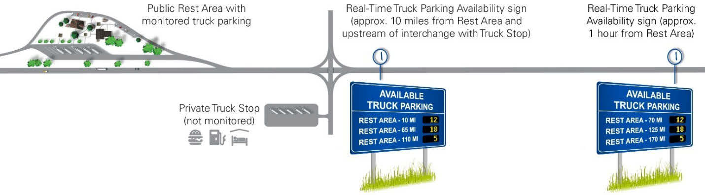
Existing/New Dynamic Message Signs. Another roadside sign option includes DMS, either existing or built for TPIMS (see Figure 9). Similar to the DPAS, a DMS could display upcoming rest areas and how many miles downstream they are along the corridor, along with the available spaces. DMS tend to be more costly than DPAS due to more dynamic messaging features that are available, as well as the larger size and associated support structure. However, an advantage of DMS is that a transportation agency has the ability to use the DMS for messaging other than TPIMS (e.g., during a major emergency the DMS could report on traveler information instead of parking availability).

Web-Based Platforms
Web-based platforms, such as traveler information websites or mobile smartphone applications, enable drivers and dispatchers to make informed route planning decisions at the beginning of their trip, as well as en route. These services can share TPIMS data on parking location and availability with truck drivers through a variety of means.
Traveler Information Systems. Traveler information websites, such as 511 programs, and smartphone applications, are relatively low-cost ways to disseminate truck parking information. Web-based platforms can display real-time truck parking cameras’ images if CCTV cameras are present at the sites. A smartphone application may sense a vehicle’s roadway heading and GPS location to present parking availability information to drivers for facilities in proximity to the vehicle’s position and travel path, whereas a website shows all of the available truck parking locations in its database. Drawbacks of relying on traveler information systems for truck parking include that the information can only be accessed by dispatchers, drivers with Wi-Fi or data plans and cellular service along the corridor, and vehicles with integrated in-cab systems. To ensure safe operations, mobile applications must comply with distracted driving laws and regulations including FMCSA’s “one-touch” compliance requirement that truck driving mobile applications rely on hands-free, voice-interactive commands.
Reservation-Based Systems. Services that provide reservations also use websites and mobile applications to provide information. In this particular use case, the information distributed is whether parking is available at a given site for reservation by a truck driver. Oftentimes, this data is kept on the private-sector parking manager’s (or the service they subscribe to) website or mobile application to maintain a competitive advantage in the marketplace.
Additional Dissemination Methods
Other methods exist for distributing TPIMS-related data, although these methods are less frequently used in the industry.
- In-Cab Systems. Many trucking companies equip their fleet vehicles with in-cab systems which provide applications for navigation, ELDs for tracking HOS, and providing fuel optimization, among others. In-cab systems may also disseminate truck parking availability data from an online data feed.
- GPS Navigation Systems. GPS navigation systems may also provide truck parking availability data from an online data feed.
- Highway Advisory Radio. Highway Advisory Radio, also known as Travelers’ Information Stations, disseminate highway information to travelers via radio. A transportation agency may provide truck parking information via a Highway Advisory Radio station.
- Citizen’s Band Radio. Individual truck drivers may communicate the availability of truck parking via CB radio.
- Other Radio Options. Satellite radio services and some local radio stations may incorporate truck parking data into their existing traveler information segments.
- Call-in Phone Systems. Using IVR technology, call-in phone systems can provide truck parking information. A driver who is looking for information would verbally call the IVR system and follow the voice prompts to get the desired truck parking information in a hands-free environment.
- Traveler Information Kiosks. Existing traveler information kiosks at truck stops and rest areas may be adapted to display truck parking information.
- Connected Vehicle Communications. Connected vehicle communications is an emerging technology that could broadcast truck parking information via I2V or vehicle-to-everything messages from roadside units and/or other large-scale communications methods. As of 2022, Connected vehicles are not common, so the supporting infrastructure is not yet present to facilitate widespread data exchange.
Data Sharing Systems
While the previous discussion primarily focused on technologies that distribute information to truck drivers, it is also important to consider tools that enable sharing data between systems. Ideally, TPIMS systems should provide seamless information to truck drivers across political boundaries. As a truck is approaching a state boundary, being able to receive information on real-time parking availability in the next
state is extremely valuable. This requires multi-state coordination to ensure that information can be shared and displayed in the most advantageous manner for freight operations.
Most agencies routinely share data with other agencies as part of their ITS program. Standards-based data feeds (or APIs) and central clearinghouses are two methods for effectively sharing data across agencies. A data exchange standard would allow any agency to ingest another agency’s TPIMS data without confusion of what data is being received. For example, as part of the MAASTO TPIMS deployment one key development was the Regional TPIMS Data Exchange Specification Document. This allowed MAASTO to standardize the data feed containing JSON scripting language so that all third-party application developers could display TPIMS data on their platforms. Another potential tool is a central clearinghouse, where data from all agencies is consolidated for distribution to private third parties. This approach provides one location to access the data for all agencies and the clearinghouse can also function as a data archive. Another alternative is to use private third parties to obtain data from individual agencies using a consistent data feed format.


