Advanced Technologies and Cooperation for Transboundary Water Resources Management: Between Science Diplomacy and Global Water Security: Proceedings of a Workshop—in Brief (2026)
Chapter: Advanced Technologies and Cooperation for Transboundary Water Resources Management: Between Science Diplomacy and Global Water Security: Proceedings of a Workshop - in Brief
 |
Proceedings of a Workshop—in Brief |
Convened June 25–26, 2025
Advanced Technologies and Cooperation for Transboundary Water Resources Management: Between Science Diplomacy and Global Water Security
Proceedings of a Workshop—in Brief
Effective management of transboundary water resources is essential to ensuring global security, economic development, and environmental sustainability. Achieving this goal requires advancing technologies to support transboundary water resources management, and connecting science diplomacy and peace-building to these issues.
The AccelNet PEER2PEER project, sponsored by the National Science Foundation and led by the National Academies of Sciences, Engineering, and Medicine, brings together global networks focused on furthering amicable and effective transboundary water management. Through these networks, the project synergizes current research initiatives, shares data and tools, and fosters collaboration in transboundary water security scholarship and capacity building to address gaps in research, existing assessment tools, education, and public and decision-maker outreach.
The AccelNet PEER2PEER project has supported several recent activities, including four workshops on transboundary water management in various regions. The first workshop, convened on September 3–4, 2022, in Bishkek, Kyrgyzstan, in partnership with the American University of Central Asia, identified common issues among the partnering regions and institutions to explore further through the project.
The second workshop, convened on November 1–3, 2023, in Samarkand, Uzbekistan, in partnership with Samarkand State University, explored opportunities for building a comprehensive assessment framework for identifying, averting, and adapting to climate-related and other vulnerabilities in transboundary water systems, focusing specifically on challenges faced by nation-states in Central Asia.
The third workshop, convened on June 24–25, 2024, in Irvine, California, addressed ways to transform the recommendations generated during the Samarkand workshop into lessons to apply at the local through trans-national levels to achieve resilience in the face of climate change and other vulnerabilities.
The fourth workshop, convened on June 25–26, 2025, in partnership with the University of Dar Es Salaam in Tanzania, focused on advanced techniques and technologies for transboundary water resources management. Discussions also covered policy approaches for more effective international collaboration, practices to increase input of water experts into policymaking, and the impacts of extreme events and hazards on global water security and diplomacy. Key themes that emerged from the discussions include the need to learn from, and improve on, failure; embrace adaptive government rather than rigid
top-down approaches; strengthen institutions to support collaboration; improve bi-directional and genuine communication; develop end-to-end tools and technologies; and build credibility between sectors and across political borders.
This Proceedings of a Workshop—in Brief provides a high-level summary of key discussions held during the June 2025 workshop. The workshop consisted of introductory remarks and keynote addresses, as well as a summary of the 2024 workshop. It also included four plenary sessions with panel presentations and breakout discussions on the following topics:
- Transboundary basin data management and tools
- Impact of climate extremes on transboundary basins
- Policy approaches and tools for transboundary basin management
- Science diplomacy and regional security in transboundary basins
JUNE 25, 2025: WELCOME AND INTRODUCTIONS
Augustina Alexander, University of Dar es Salaam, welcomed participants and introduced the workshop topics—advancing technologies for transboundary water resource management and connecting science diplomacy, global water security, and peace-building. She noted that these topics are particularly relevant and important to Tanzania, which shares greater than 77 percent of all of its river and lake basins with neighboring countries1 and is governed by numerous treaties and memoranda of understanding (MOUs). It also has a unique geopolitical and hydrologic landscape and serves as a compelling case study of diplomacy.
Dalal Najib, National Academies, also welcomed participants and added that workshop discussions will explore solutions to the critical challenges facing transboundary water management by leveraging and connecting existing National Academies networks. She also drew attention to two pre-workshop training sessions, one for government officials on confidence building during water negotiations and the other for early career researchers on the use of geographic information systems (GIS) technology for water resource analysis.
Summary of the ACCELNET PEER2PEER’s 2024 Workshop
David Feldman, University of California, Irvine, summarized six strategies to achieve resilience in the face of climate change and other vulnerabilities, as identified through plenary presentations and breakout group discussions during the third PEER2PEER workshop held in 2024 in Irvine.
- Enhance integrated resource management. Participants discussed the need to collaborate to develop alternative water sources and improve irrigation efficiency and conservation efforts. They also discussed opportunities to increase cross-national data sharing and foster adaptation by embracing local knowledge.
- Foster close collaboration. Participants identified the need to recognize national governing differences and their implications, seek food and energy security, and expand water sharing. Other actions to foster collaboration include integrating hydrological/ecological knowledge across national boundaries and encouraging bottom-up, informal collaboration that respects cultural diversities.
- Enrich interdisciplinary knowledge. Participants discussed assessing vulnerability at the country level. PEER2PEER is developing an assessment that incorporates country-level data and societal resilience measures including coping capacity, governance, water availability, and climate. Participants were encouraged to recognize country-specific conditions, political variabilities, veracity of demand forecasts, and impacts to especially vulnerable groups.
- Build resilience in transboundary water systems. Participants discussed high-profile technological options to address water challenges, which can be expensive and may have other consequences yet may be necessary in some cases. Opportunities may exist to adopt better demand management approaches. In addition, water supply infrastructure is a challenge in much of the world.
__________________
1 https://www.maji.go.tz/uploads/publications/sw1562756943-Benefits%20%26%20Challenges%20of%20Transboundary%20Water%20Cooperation%20for%20Tanzania.pdf
- Fortify adaptation approaches. Participants highlighted the need to incorporate indigenous voices in solutions and to understand perceptual differences toward water equity/justice. The extent to which analysis can be downscaled is crucial (e.g., local vs basin scale). Adaptation also includes efforts to ensure that databases consistently encompass hydrology, ecology, meteorology, economic, and social information.
- Enhance innovation capacity. This strategy requires rejecting older, path-dependent approaches to water management and exercising foresight when confronted by unprecedented challenges such as anthropogenic climate change. Discussions highlighted the importance of inviting stakeholders into innovation discussions as early as possible, which is critical for equitable and democratic water management.2
Feldman also summarized several lessons learned during the Irvine workshop:
- Acknowledge how institutionalized water rights systems and other established practices can impede transboundary cooperation.
- Recognize how climate vulnerability is determined by both endogenous (e.g., income, gender, ethnicity) and exogenous (e.g., water availability, drought) factors.
- Invest in data literacy and access to make climate and water information both useful and usable.
- Incorporate public concerns in decision-making by investing in education and outreach. Collaboration works best when it incorporates all voices.
Transboundary Water Resources Management Under Climate Change and Extreme Events: Strategies for Resilience and Cooperation
During the keynote presentation, Joel Nobert, University of Dar es Salaam, provided an overview of the complexities of managing shared water resources in Tanzania, where seven of the nine major river basins are transboundary. This complexity is due to varying water demands and political interests. Shared basins are also vulnerable to climate change and extreme hydrological events (e.g., floods, droughts). Thus, resilient, cooperative, and data-driven strategies to address these complexities are needed.
Nobert discussed the Lake Victoria Basin, noting that climate projections for the region, based on Coupled Model Intercomparison Project Phase 6 (CMIP6) models, forecast a noticeable increase in precipitation for the basin, with an average anticipated increase of 5 percent by 2040–2069 and 16 percent by 2070–2099. Extreme rainfall events are also expected to increase in intensity. Lake Victoria has experienced dramatic water-level changes, including record lows in the 1920s, a sharp rise in the 1960s, a dip in 2006, and record-high levels and severe flooding in 2019–2020. These fluctuations result from a combination of climate variability and change, as well as human operational rules for water release. Nobert also discussed extreme events and observed water-level variability in the lake region, noting that record flooding between 2019 and 2020 was due to a surge in lake levels of about 1.21 m, the highest in 30 years.
Nobert described the Nile Basin Initiative, which is a critical confidence-building measure that led to the development of the Nile Basin Decision Support System. This shared database and modeling tool is used by all riparian countries. Although data-sharing protocols remain a challenge, the database was a significant milestone.
Nobert presented a case study focused on data collection in transboundary water allocation planning in the Mara River Basin, which is an important transboundary basin shared between Kenya and Tanzania. The first stage of this case study aimed to complete a country-specific water allocation plan for each party to the Mara River Basin (Kenya and Tanzania) and then gain approval from the Tanzanian Ministry of Water (see FEBRUARY). The second stage aimed to harmonize the two plans into a single cohesive plan for approval by both countries and the Lake Victoria Basin Commission.
The project included inclusive data collection with broad stakeholder engagement aimed at fostering resilience. Both countries used locally collected data for trust-building and model accuracy. Tanzania finalized and pub-
__________________
2 Specific examples of strategies, technologies, and further details on points raised during the 2024 workshop can be found in National Academies of Sciences, Engineering, and Medicine. 2024. Learning Resilience: Lessons for Managing Global Transboundary Water Vulnerabilities: Proceedings of a Workshop—in Brief. Washington, DC: The National Academies Press.

SOURCE: Zielinksi et al. (2023).3
licly shared its water allocation plan in 2020. Kenya’s plan was drafted in 2018 but was neither ratified nor published.
The project faced several challenges and offered some important lessons:
- Institutional mismatches. Differing degrees of engagement by water authorities created communication gaps. In Tanzania, the Ministry of Water was engaged throughout the process, ensuring ownership and quick approval, while in Kenya, the Ministry was less involved, leading to mistrust in the data and delayed approval.
- Lack of effective legal frameworks. The absence of a strong legal framework for data sharing hindered progress.
- Trust through data collection. Using locally collected hydrological data increased confidence in the process. Exchanges among field staff promoted learning and standardization of methods.
- Political and financial limitations. Joint committees under the 2015 MOU are not fully functional, meet infrequently, and depend on donor funding. In addition, there is no legal obligation to finalize the joint water allocation plan.
- Coordination failures. The process suffered from a lack of initial consultation, leading to criticism and delays. Harmonizing the separate national plans has proven difficult.
Nobert also provided the example of the Songwe River Basin, which is shared by Tanzania and Malawi and has been increasingly affected by flooding and climate-driven hydrological shifts and several key response efforts. Approximately 52,000 people live in the floodplain and are regularly impacted during heavy rains. In April 2022, torrential rains caused severe flooding in the Mbeya and Songwe regions (Tanzania), resulting in at least five deaths and widespread population displacement. Flooding is the primary issue in the area, driven by deforestation and sediment accumulation.
__________________
3 L. Zielinski, M. McClain, W. Ojwang, et al., “Using Data Collection to Build Trust and Ownership in Transboundary Water Allocation Planning: A Case Study from the Mara River Basin,” Water International 48, no. 8 (2023): 1014–1024, https://doi.org/10.1080/02508060.2023.2291241.
The Songwe River Basin Commission was established in 2017 to provide cooperative transboundary water governance. The Strengthening Transboundary Cooperation and Integrated Natural Resource Management in the Songwe River Basin project, funded by the African Development Bank, is planning a multipurpose dam (115 m, 330 mm3) to provide flood control in the lower basin, hydropower, and irrigation for 3,000 ha per country along with water supply for about 86,000 residents.
A flood forecasting and early warning system was also developed (2022–2024) to enhance hydro-meteorological forecast capabilities. In addition, agroforestry and catchment restoration via pilot projects (e.g., Misuku Hills) were instituted to stabilize riverbanks and reduce siltation, jointly led by Malawi and Tanzania. A collaborative planning workshop led by the International Water Management Institute (IWMI) and the International Union for Conservation of Nature (IUCN) fostered a transboundary nexus approach to identify priority activities for flood alleviation and water management.
PLENARY I PANEL: TRANSBOUNDARY BASIN DATA MANAGEMENT AND TOOLS
Ali Mirchi, Oklahoma State University, moderated the panel focused on advanced tools and methods for transboundary water management.
Yadu Pokhrel, Michigan State University, discussed a multi-scale modeling approach to understanding the impacts of climate change on water management. By the late 21st century, agricultural, ecological, and hydrological droughts will dramatically affect global land use. Droughts are expected to worsen substantially, with 488 million people facing extreme or exceptional drought by mid-to-late century. Needed are convergent and transdisciplinary science approaches to cope with these climate extremes and enhance disease resilience.
Pokhrel described his work to combine large-scale climate drivers, general hydrological models, and fine-scale hydrodynamic models to simulate water availability, floods, and infrastructure impacts (e.g., dams) down to the city level. He also described case studies in Asia and Africa. In the Mekong/Himalayas regions, modeling shows how upstream dam operations impact downstream water availability, flooding, and ecosystem health in major deltas. In sub-Saharan Africa, a similar modeling effort in the Nile, Niger, and Congo basins is being applied. Initial results indicate a trend of increasing floods alongside overall decreasing water availability during low-flow seasons.
Future research directions include developing a “digital twin” of large river systems using artificial intelligence (AI) for advanced flood forecasting. This approach will support design of solutions to the water-energy-food nexus, scenario analysis and planning, and development of near real-time monitoring and forecasts.
Pokhrel noted that regional cooperation can be strengthened by aligning modeling efforts with regional initiatives and promoting data harmonization and joint scenario planning. Regarding stakeholder engagement, he noted the need to co-design tools with regional/local end users in order to enhance local resilience capacity.
Venkataraman Lakshmi, University of Virginia, discussed the use of earth observations for transboundary water management. Many transboundary watersheds and aquifers necessitate meaningful discussion between countries to ensure effective sharing of water resources. In-situ observations are either sparse or of questionable quality and cannot provide a good representation of the physical state of water distribution. Sharing of water data is also sometimes limited by a lack of binding agreements between countries.
Earth observations data that are publicly available and open to analysis can play a vital role in promoting open science and informing water resources management decision-making. Because water does not respect political borders and in-situ data are often not shared, publicly available and open earth observations data are an essential component of transboundary systems monitoring. Lakshmi described several related tools and findings. For example, his group developed high-resolution (1 km) soil moisture products that reveal localized hydrological conditions, identifying perennially dry sub-watersheds within the Lake Victoria Basin.
Satellite remote sensing helps to capture a better picture of the earth’s water system, as shown by work in the Nile, Mekong, and La Plata basins. However, the need to collect in-situ observations remains, Lakshmi said.
In-situ observations are the cornerstone of calibration and validation of earth observations, and of hydrological models. With changing precipitation patterns, increasing population, and stress on water resources, use of earth observations for effective water resources management of transboundary watersheds and aquifers is necessary.
Emmanuel Asiedu Brempong, Google Research Africa, began his remarks by stressing the need to improve weather forecasting in Africa, where the limitations of existing global weather models complicate efforts to prepare for extreme weather events or to maximize agricultural yields. Traditional global weather models perform poorly over Africa, and modern AI-driven models require dense ground-based radar networks that are virtually nonexistent on the continent.
Weather radar coverage in Africa is lacking. Africa has only 37 radar stations compared to 345 in Europe and 291 in North America. Further, the weather stations in Africa do not have digitized data and are not distributed throughout the continent.
Nowcasting, which is based on deep learning models, can provide crucial early warnings, especially in Africa where rainfall is sudden and existing weather forecast infrastructure is lacking. To address this need, Google’s team built a new nowcasting model that replaces ground radar and weather station inputs with data from satellites. Specifically, this AI model incorporates IMERG precipitation products and geostationary satellite imagery. Trained solely on satellite data, this model now significantly outperforms traditional numerical weather models across Africa and has been integrated into Google Search. Future work will focus on creating better, AI-generated, real-time, global precipitation data.
PLENARY I BREAKOUT DISCUSSIONS
In the first set of breakout discussions, four groups focused on transboundary basin data management and tools.
Regarding key modeling and data gaps and opportunities to improve vulnerability assessments in transboundary basins, participants discussed the need for a bottom-up data collection system. They also noted the importance of modeling future climate and impacts; the creation of a global data water center; and holistic, realistic modeling at relevant scales.
Participants commented that the private sector can play a role in expanding and improving data collection, for example, by providing data as well as economic incentives to encourage open data provision and dissemination. Participants identified the following approaches to support effective water diplomacy:
- Investment in citizen science
- Integrated data management
- Standardized methodology approaches
- Additional data harmonization and documentation
- Creation of open data platforms
- Development of data visualization tools
- Additional research funding
Participants suggested that gaps in water management strategies can be addressed by, for example, identifying opportunities to benefit upstream and downstream parties equally to avoid conflict; increasing investment in water supply projects, which receive less attention than water management projects; and developing mechanisms to adapt the water infrastructure that was built under assumptions of climate stability.
Finally, participants suggested a review of existing joint management commissions to determine how they were formed, how they operate, and how they might serve as examples for similar commissions charged with preventing transboundary water conflicts.
PLENARY II PANEL: IMPACT OF CLIMATE EXTREMES ON TRANSBOUNDARY BASINS
Amir AghaKouchak, University of California, Irvine, moderated a panel on the impact of climate extremes on transboundary basins. Panelists discussed the resilience and societal impacts of these climate extremes, particularly from the demand perspective.
Temur Khujanazarov, Kyoto University, discussed resilience in the Aral Sea Basin, a region facing extreme water stress, competition between countries, and pressures from agricultural development in upstream Afghanistan. A key dimension of resilience is the ability to anticipate and respond to diverse types of risks.
To become more resilient, the region plans to expand the use of water-saving technologies in agriculture. For
example, Khujanazarov’s team is developing a high-resolution simulation model for Central Asia, integrating on-the-ground sensor data with process-based and machine learning–driven models for key inputs, such as solar radiation, land cover change, and land surface parameters. To assess flash droughts and heat waves, new indices based on the output of a land surface model are in development. The goal is to provide timely, reliable, and open data to different stakeholders (from farmers to policymakers) to better manage limited resources and assess risks such as “flash droughts” on a shorter timescale. Water-saving technologies are not a panacea and must be complemented by better salinity management and soil restoration to achieve lasting impact.
Khujanazarov added that user-friendly decision-support tools are needed to help policymakers anticipate and respond to climate, natural resource, and market stresses at both local and national levels. Long-term monitoring can strengthen this process, because continuous data collection is a key to understanding how crop yields and water use respond to climate changes over time. Future research should focus on water productivity, climate resilience, and integrated approaches that link technology, ecosystems, and governance.
Mojtaba Sadegh, Boise State University, discussed the concept of “anthropogenic drought,” which is a compound, multiscale, and multidimensional phenomenon, governed by a combination of human decisions and activities, climate change, natural water variability, and altered micro-climate conditions resulting from changes in land and water management. Anthropogenic drought magnifies the gap between water supply and demand and can lead to water bankruptcy where water demand invariably exceeds available supply. Managing this phenomenon by increasing the water supply alone will not be successful.
Sadegh discussed the Tigris-Euphrates Basin, which encompasses Turkey, Syria, Iraq, Iran, Jordan, and Saudi Arabia. The basin has undergone decades of extensive dam construction, resulting in more than 250 km3 of storage that has drastically altered the flow regime, and has modified the magnitude, timing, and seasonality of river flows. The result is a shortage of water in the downstream.
Sadegh also discussed the Helmand River Basin in Afghanistan and Iran. Despite a decade of wet years in the upstream Afghanistan portion of the basin in the 2010s, the downstream lakes in Iran have not recovered from a major drought that started in the late 1990s. Most of the lakes are now dry. This state is due to agricultural expansion mainly in the upstream, as well as the construction of reservoirs in the downstream; the former has permanently increased water demand, while the latter has prevented water from reaching the terminal lakes, collectively causing dust storms and degrading water quality.
PLENARY II BREAKOUT DISCUSSIONS
Breakout group discussions focused on the impact of climate extremes on transboundary basins. During the session, participants focused on several issues related to coordination:
- There is a need for coordination between upstream and downstream states on fisheries and other assets as well as water.
- Climate extremes can lead to conflict but can also facilitate collaboration and incentivize data collection. Climate-related conflicts can also alter the direction of water diplomacy.
- Floods, which have immediate and intense impacts, tend to motivate greater collaboration as compared to droughts, which have evolving and creeping impacts.
- Groundwater is not often adequately considered in treaties. To address this issue, participants discussed bringing together technical innovations that may be developed by one party and co-funded by another party, which benefits both parties.
- Water diplomacy is a slow and incremental process.
Participants noted that coordination between upstream and downstream water users can take formal or informal forms. Although treaties provide structured agreements, they are often slow to negotiate, whereas informal communication among reservoir operators enables more flexible and immediate coordination.
Participants also noted that climate extremes play a dual role in transboundary water relations. They can heighten conflict—especially over less visible resources such as groundwater—but they can also spark collaboration, as seen when Tanzania and Malawi jointly built a dam to manage floods. Public pressure after such events can drive governments to act. Regional and political contexts heavily influence these outcomes; for example, southeastern European countries have cooperated after extreme events when political conditions were favorable. Floods tend to promote cooperation, while droughts often lead to disputes over scarce water.
Groups also found that uncertainty in climate models complicates planning, and some actors use climate change as a way to shift blame for poor management. Water diplomacy itself is a slow, continuous process that can be accelerated by crises. Extreme events may trigger cooperation, data sharing, and new regulations, but they can also delay progress or deepen inequalities when power imbalances exist. Overall, climate extremes can reshape the direction of water diplomacy—either fostering collaboration or intensifying conflict.
WATER RESOURCE VULNERABILITY AND COPING CAPACITY FRAMEWORK
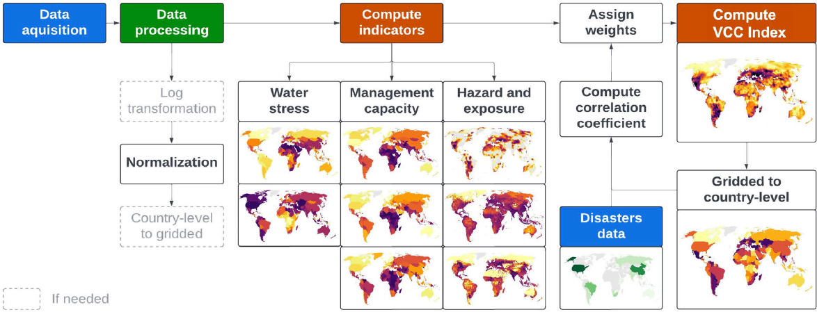
Debora de Oliveira and Amir AghaKouchak, University of California, Irvine, presented the nearly finalized Water Resource Vulnerability and Coping Capacity (VCC) Framework. For context, AghaKouchak noted that the working group met more than four years ago to begin development of a framework that could be applied to water resources decisions. The resulting framework (see Figure 2) considers various aspects of vulnerability to droughts, such as water availability and demand, stressors, measures of social resiliency and coping capacity, and level of exposure and vulnerability based on population and agricultural production.
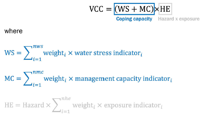
The framework captures coping capacity and hazard and exposure data. Coping capacity considers water stress indicators (water availability and water demand) and management capacity indicators (Human Development Index and government effectiveness) (Box 1). Hazard and exposure are captured through hazard indicators such as the Standardized Precipitation-Evapotranspiration Index and exposure indicators (population, cropland, and pasture).
Regarding data acquisition and selection for the framework, Oliveira and AghaKouchak discussed the use of all freely available and comprehensive global datasets. They also considered the level of exposure based on both population and agriculture. The framework’s data can be accessed through Google Earth Engine, which enables users to combine the framework with various datasets of their choosing.
SOURCE: Debora de Oliveira and Amir AghaKouchak, University of California, Irvine.
BOX 1
Framework Inputs and Weights
JUNE 26, 2025: TRANSBOUNDARY WATER RESOURCE MANAGEMENT IN TANZANIA
Tumaini Mwamyalla, Ministry of Water, Tanzania, provided keynote remarks related to Tanzania’s transboundary waters. Transboundary water resources management refers to the cooperative process of managing water bodies—such as rivers, lakes, and aquifers—that cross or demarcate political boundaries between two or more countries. Tanzania shares transboundary waters with 16 neighboring countries, including eight rivers, six lakes, and eight aquifers. Mwamyalla emphasized the critical need for agreements and protocols to manage these shared resources effectively.
Sound management and use of transboundary water resources requires understanding and agreement among riparian states. Mwamyalla discussed the key agreements to which Tanzania is a party, including protocols for the Nile Basin, Lake Victoria, Lake Tanganyika, the Zambezi River, Ruvuma River, and the Songwe River Basin. These agreements and collaborations have benefited the region through funding of water and hydropower projects, improvements to water management practices, data sharing, and support for capacity-building initiatives. These projects have also enhanced trust and communication between partnering nations. However, she noted that without the capacity to create joint management mechanisms, meaningful transboundary cooperation, such as the regular exchange of data and information and coordinated water management plans, cannot be achieved.
Tanzania’s Ministry of Water regularly schedules government and private-sector stakeholder dialogues to disseminate information related to past and ongoing transboundary processes and initiatives. However, collaborations with other countries can face challenges, including differing legal frameworks, inadequate management capacity, decision delays, inconsistencies in policy implementation, and financial constraints that sometimes delay partner contributions to joint commissions.
Transboundary cooperation fosters peace, security, and sustainable management. Overall, the benefits realized through transboundary water resource collaboration have outnumbered the challenges, Mwamyalla said.
PLENARY III PANEL: POLICY APPROACHES AND TOOLS FOR TRANSBOUNDARY BASIN MANAGEMENT
Feldman moderated a panel discussion focused on policy approaches and tools for transboundary basin management.
Andrea K. Gerlak, University of Arizona, discussed policy approaches related to the transboundary Colorado River Basin. The Colorado River runs 2,330 km from the Rocky Mountains to the Gulf of California, draining parts of seven U.S. states and two Mexican states. About 27 km of
the river is considered an international boundary between the United States and Mexico. About 40 million people and 30 federally recognized tribes rely on the Colorado River. It is highly impacted by climate change and is overly utilized and heavily developed.
Gerlak discussed the 1944 U.S.–Mexico Treaty, a landmark agreement that established the International Boundary and Water Commission (IBWC, Spanish: Comisión Internacional de Límites y Aguas, CILA) to resolve water disputes. A key strength of the treaty is its “minute” process, which allows for flexible amendments to adapt to changing conditions. She described discussed recent amendments (i.e., minutes) to the U.S.–Mexico Treaty:
- Minute 318 (2012). Following a 2010 earthquake in Mexico that damaged its infrastructure, the United States agreed to store Mexico’s water allocation in its reservoirs, marking a significant shift in cooperative management.
- Minute 319 (2012–2017). For the first time, water was allocated specifically for environmental restoration, creating a “pulse flow” to mimic the river’s natural state and revive the delta ecosystem.
- Minute 323 (2017–2025). The Binational Water Scarcity Contingency Plan was established.
Gerlak also discussed the Transboundary Aquifer Assessment Program (2006–2015), which established binational working groups to conduct joint fact finding and scientific assessment of the state of shared groundwater resources. The effort included inventorying and harmonizing available data and information but has not yet resulted in a new minute.
Gerlak added that environmental nongovernmental organizations (NGOs) have been instrumental in raising funds and creating coalitions in the basin, for example, supporting efforts such as “Raise the River” to lease water rights for restoration, proving that nongovernmental actors can fill critical policy gaps.
Gerlak said that policy approaches have been adaptive and responsive to modern challenges in the basin. The minute process reflects an evolution in legal approach. The Delta is on the mend as a result of modern policy approaches and new tools.
Khaled AbuZeid, Regional Water Program Manager, CEDARE, first defined blue, green, and virtual water. Blue water is surface or groundwater that is abstracted for the purpose of development or production. Green water is the share of beneficial abstraction of renewable water resources from green cover, which comes from atmospheric water and is consumed by natural pasture, rain-fed agriculture, and forests. Virtual water is the (blue and green) water embodied in a product or needed to produce the product.
AbuZeid discussed water resources within the Nile Basin, including rainfall levels (see Figure 3). The Nile Basin is shared by 11 countries. There is considerable variation in precipitation and evapotranspiration throughout the basin and significant amounts of green water use upstream.
Holistic assessment of both blue and green water is needed to understand dependencies. For example, Egypt and Sudan rely heavily on blue water from the Nile, while Ethiopia’s agriculture relies more on green water. Accounting for virtual water is also important, for example in the context of exports of food and textiles, to reveal hidden water dependencies and inform more equitable resource management strategies.
AbuZeid offered recommendations for advancing science diplomacy in transboundary water management:
- Close the gap between legal, technical, and political matters by recognizing the importance of prior consultation on large water projects.
- Assess the amount of existing blue and green water resources.
- Use remote sensing technology to address data gaps.
- Improve rain-fed agriculture and green water use.
- Advance scientific research on assessment of equitable and reasonable utilization.
Bunyod Holmatov, International Water Management Institute, discussed the roles of various approaches and tools in building partnerships for sustainable cooper-

SOURCE: Khaled AbuZaid, CEDARE.
ation on shared waters. He presented several practical case studies to demonstrate how the creation of enabling conditions such as overarching frameworks, data sharing arrangements, and decision-support systems—can facilitate benefit sharing and sustainable cooperation. The case studies are as follows:
- Rapid Assessment Process. This stakeholder-driven methodology enables rapid data and information collection for monitoring of basin conditions and state of cooperation, even with minimal financial resources.
- The Water-Energy-Food Nexus Approach. The European-funded Hydro4U project generated tangible benefits, such as electricity, from small hydropower plants on transboundary rivers in Central Asia. These benefits helped improve local socioeconomic conditions (e.g., new jobs creation), which won government buy-in for joint cross-border projects.
- Water Resources Modeling. Application of the pywr (Python Water Resources) model—a decision-support system—simulated impacts of different interventions in Central Asia for better foresight and conflict prevention.
- Standardized Sub-Basin Agreement Templates. These templates streamlined the process of capturing key indicators and codifying sub-basin cooperation.
Holmatov also discussed the key barriers to building lasting partnerships and sharing benefits, including data and information scarcity, lack of political will and/or capacity and of public awareness, financial issues, and climate change.
PLENARY III BREAKOUT DISCUSSIONS
The third breakout discussions focused on policy approaches and tools for transboundary basin cooperation. Participants noted that many transboundary water agreements do not equally benefit all partners. To address this and other challenges through collaboration, participants discussed the need for the following:
- Open and accessible science communication and tools
- Additional funding, including for continued support of projects once they are completed
- Cost-sharing opportunities between parties
- Verification tools for collaboration
- Programs to expose more scientists to the policy world
- More exploration of the potential of AI to support transboundary water management issues
- Science to be a foundational part of the negotiation process
Participants also noted the existence of opportunities to tap into other regional institutions to support collaboration on transboundary water issues. The National Academies and other related institutions can serve as mechanisms to advance collaboration.
PLENARY IV PANEL: SCIENCE DIPLOMACY AND REGIONAL SECURITY IN TRANSBOUNDARY BASINS
Dalal Najib moderated the final panel focused on science diplomacy and regional security in transboundary basins.
Andrew Gronewold, University of Michigan, presented on how to preserve and modernize multi-institution strategies for coordinating transboundary water management data and tools. He discussed recent research in this area, noting the significant data gap around large lakes until about 15 years ago. The International Joint Commission, which covers activities in the Canada–United States transboundary region, which includes the Great Lakes, was established in 1909 and helps to close that data gap.
Gronewold noted efforts to blend remote sensing data with in situ data to encapsulate total water balance, which will enable long-term forecasting. In addition, reproducing key statistics offers the potential to re-simulate the water dynamics important for hydropower. He also noted efforts to assess hydroclimate changes in the Lower Rio Grande Basin, adding that snow melt in the Basin upstream dries out in the “Forgotten Reach (lower basin).” Water accumulates again via the River Conchos.
Finally, Gronewold discussed a recent convening focused on the use of machine learning and AI to support observations, modeling, and forecasting in the Great Lakes. During the session, participants discussed the need to enhance predictive models and improve observational network design, as well as a framework for a Great Lakes machine learning/AI community of practice.
Sogol Jafarzadeh, United Nations University Institute for Water, Environment and Health (UNU-INWEH), works to solve pressing environmental and health problems around the globe and collaborates with the UN Member States and other partners on research.
She highlighted two UN water-related conventions:
- UN Watercourses Convention (1997). This global framework convention codifies principles of international water law and governs the rights and obligations of states sharing transboundary watercourses. Although adopted, its implementation has been limited, partially due to the absence of strong leadership by key countries.
- Convention on the Protection and Use of Transboundary Watercourses and International Lakes (1992). Often referred to as the UNECE Water Convention, this treaty provides a unique legal and intergovernmental framework to promote cooperation and sustainable use of transboundary water resources. Originally negotiated as a regional instrument under the UN Economic Commission for Europe, it was opened to all UN Member States in 2016, making it a global legal framework.
She also noted the UN system-wide strategy for water and sanitation, which is coordinated through UN-Water. Within this framework, UNU-INWEH and the UN Department of Economic and Social Affairs (UNDESA) co-facilitate the Task Force on Water Action Decade Implementation. The Task Force aims to build ambition and mobilize stakeholders ahead of UN Water Conferences, creating platforms that inform policy, engage stakeholders, and strengthen science-policy linkages. The next UN Water Conference will occur on December 2–4, 2026, in the United Arab Emirates, with the aim of accelerating progress toward Sustainable Development Goal 6 (clean water and sanitation).
Finally, she highlighted ongoing UN and partner initiatives to strengthen women’s leadership in water governance. These include efforts to empower women in the water sector and to expand their representation in decision-making, such as the Women in Water Diplomacy Network, which works to achieve gender equality in transboundary water cooperation.
Raha Hakimdavar, Georgetown University, first discussed water stress in the Middle East and North Africa. This region is the most water stressed in the world, which is worsening with climate change and high population growth. For example, Qatar receives about 80 mm of rainfall per year, compared to about 1,200 mm per year in Dar es Salaam. Qatar also has high per capita water use rates.
Qatar’s freshwater is derived totally from groundwater; there is no surface water. This situation is generally true for the Gulf Cooperation Council countries. Climate change is compounding water problems. Hakimdavar presented a measure of vulnerability to the effects of climate change and the readiness of countries to adapt to climate change.
Hakimdavar also discussed the Sand and Dust Storm Monitoring Initiative, a Saudi-led program backed by more than $10 million, which will help to predict storm events that affect air quality, agriculture, and logistics across the Middle East and North Africa. She also discussed the International Drought Resilience Observatory, which consolidates global, satellite-based, drought early warning systems and is used to monitor soil moisture, vegetation stress, and water availability.
PLENARY IV BREAKOUT DISCUSSIONS
During the final breakout session, participants discussed policy approaches to transboundary water collaborations. The following key points emerged from the discussion:
- Successful collaborations require involving a diverse range of stakeholders, from national governments and technical experts to local water user associations and NGOs (bottom-up approach).
- Third parties (e.g., international organizations, NGOs, academic institutions) can be crucial for mediating, providing technical expertise, and securing funding. However, their neutrality and motives must be clear at the outset for their efforts to be effective.
- Funding is essential for sustaining projects and commissions. However, reliance on external project-based funding can create instability once a project ends. Sustainable national contributions are needed.
- Aligning national laws and policies is a logical and necessary step but is often a long-term process requiring significant political will.
- Science should be translated into accessible formats (e.g., one-page policy briefs, clear visuals) for policymakers. Building a common language and understanding is a prerequisite for success.
THE WAY FORWARD AND CLOSING REMARKS
Mirchi and AghaKouchak highlighted opportunities for collaboration and professional development, including a session on transboundary waters during the American Geophysical Union Fall Meeting and the American Society of Civil Engineers Visiting International Fellows Program.
Najib suggested the U.S.–Africa Frontiers of Science, Engineering, and Medicine Symposium and the National Academies’ Science and Technology Policy Graduate Fellowship as valuable programs for emerging leaders and recent graduates.
Feldman synthesized the workshop’s discussions, emphasizing several key takeaways for moving forward:
- Learn from failure. Shortcomings in past collaborations provide valuable opportunities for learning and improvement.
- Use adaptive governance. It is important to move from rigid, top-down management to flexible, nimble arrangements that encourage bottom-up collaboration and trial-and-error practices.
- Strengthen institutions. Success relies on robust coordinating institutions with clear objectives and enforcement/compliance mechanisms.
- Emphasize two-way communication. Genuine engagement with, and listening to, stakeholders is essential.
- Develop end-to-end tools. Scientific tools should be designed to address specific policy questions and be accessible to decision-makers at various levels.
- Build credibility. As academics and scientists, working across disciplinary and national boundaries enhances credibility and sets an example for the cross-border collaboration required of policymakers.
The workshop concluded with an acknowledgment of the hosts at the University of Dar es Salaam and all participants for two days of productive discussions.
DISCLAIMER This Proceedings of a Workshop—in Brief was prepared by Daniel Placht and Jennifer Saunders as a factual summary of what occurred at the meeting. The statements made are those of the rapporteurs or individual meeting participants, and do not necessarily represent the views of all meeting participants, the planning committee, or the National Academies of Sciences, Engineering, and Medicine.
PLANNING COMMITTEE Amir AghaKouchak (Co-Chair), University of California, Irvine; David Feldman (Co-Chair), University of California, Irvine; Esra Aleisa, Kuwait University; Augustina Alexander, University of Dar Es Salaam; Annika Hjelmstad, University of California, Irvine; Kasra Khodkar, Oklahoma State University; Ali Mirchi, Oklahoma State University; and Debora Yumi de Oliveira, Mackenzie Presbyterian University. The National Academies’ planning committees are solely responsible for organizing the summit, identifying topics, and choosing speakers. Responsibility for the final content rests entirely with the rapporteurs and the National Academies.
REVIEWERS To ensure that it meets institutional standards for quality and objectivity, this Proceedings of a Workshop—in Brief was reviewed by Esra Aleisa, Kuwait University; David Feldman, University of California, Irvine; John Sabo, Tulane University; and Mojtaba Sadegh, Boise State University. Marilyn Baker, National Academies of Sciences, Engineering, and Medicine, served as the review coordinator.
SPONSOR This material is based upon work supported by the National Science Foundation under Award 2114701. Any opinions, findings, conclusions, or recommendations expressed in this publication do not necessarily reflect the views of any agency or organization that provided support for the project.
STAFF Daniel Placht, Program Officer, Office of International Networks, Cooperation, and Security; and Brittani Shorter, Senior Program Assistant, Office of Fellowships
SUGGESTED CITATION National Academies of Sciences, Engineering, and Medicine. 2026. Advanced Technologies for Transboundary Water Resources Management: Between Science Diplomacy and Global Water Security: Proceedings of a Workshop—in Brief. Washington, DC: National Academies Press. https://doi.org/10.17226/29338.
For additional information regarding the workshop, visit https://www.nationalacademies.org/programs/PGA-CAPACITY-20-01
 Copyright 2026 by the National Academy of Sciences. All rights reserved. |


