Snapshots of Planning Practices (2025)
Chapter: Background
Background
NCHRP 08-128 Snapshots of Planning Practice adds to a body of work in which “snapshots” of practice are developed with a focus on current and emerging topics in transportation planning. The purpose of the Planning snapshots is to create a resource that is easily accessible and relevant to both practitioners and decision-makers. Snapshots serve as a resource for practice development and provide information for realistic practice implementation and program advancement.
The Snapshots address the following topics:
- Complete Streets | Policies, methods, tools, and processes used by State Departments of Transportation (DOTs) and Metropolitan Planning Organizations (MPOs) to accommodate different modal uses of the roadway and roadway rights-of-way.
- Data Sharing for Performance Management | Strategies, methods, processes, and procedures for identifying, adopting, and sharing specific data and planning performance metrics.
- Collaboration on Freight Delivery in Local Communities | Successful collaborations between State DOTs, MPOs, local governments, and private sector freight providers to address the growing demands of goods movement.
- Economic Analysis to Support Decision-making | Processes and tools used by State DOTs, MPOs, and local transportation agencies to assess and evaluate the economic value of transportation investments to inform decision-making.
The Snapshots each feature four pages which provide information on the state of the practice area, key practices and levers of change, agency examples, and resources. The navigation (or “cover”) page provides visualizations and a topic overview and directs practitioners to the Snapshot content most useful to them. The subsequent pages, “Key Practices”, “Agency Examples”, and “Resources” are organized along a spectrum including “Designing,” “Enhancing,” and “Advancing” to provide useful information for agency programs at different levels of implementation.
“Key Practices” quickly identifies what agencies in each area of the spectrum are doing. Key Practices were divided into three elements common across all columns:
- Organization, Workforce, and Partnerships | Key Practices identified in this category describe activities related to the development of relationships internally and externally to advance a policy or program, workforce capacity or training needs, and topics related to the structure of the organization itself.
- Data and Performance Management | Key Practices identified in this category describe activities related to data collection and management, data sharing, monitoring and evaluation, and performance reporting.
- Policy and Program Design | Key Practices identified in this category describe activities related to establishing or expanding programs or policies to achieve the desired outcomes.
SNAPSHOTS OF PLANNING PRACTICES:
COMPLETE STREETS
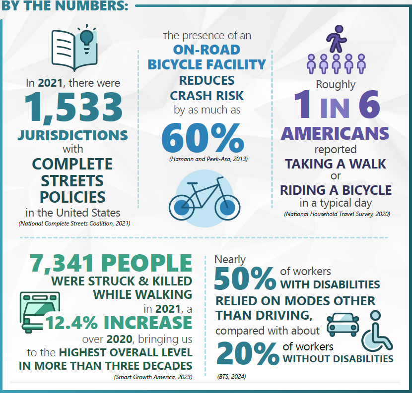
WHY MAKE STREETS “COMPLETE”?
Complete Streets are streets designed and operated to enable safe use and support mobility for all users. Complete Streets reduce motor vehicle-related crashes and both pedestrian and bicyclist risk. This helps to promote walking and bicycling by providing safer places to achieve physical activity through transportation. Transit is another key element of Complete Streets. Streets designed to facilitate transit use encourage more people to choose that mode.
FOLLOW THESE LINKS TO LEARN MORE IF YOU ARE LOOKING FOR….
- Resources on standing up a Complete Streets program →
- Key practices for starting a Complete Streets program →
- Resources for advancing/growing a Complete Streets program →
- Key practices for advancing/growing a Complete Streets program →
- Examples of what other DOTs are doing with Complete Streets →
- Examples of what MPOs are doing with Complete Streets →
SNAPSHOTS OF PLANNING PRACTICES:
COMPLETE STREETS | KEY PRACTICES
Different organizations might optimize their approach towards Complete Streets by focusing on one or more “levers of change” within their organization. These levers of change – Organization, Workforce, and Partnerships; Data and Performance Management; and Policy and Program Design – are the organizing framework of these key practices. This structure is intended to offer practices in each area so that organizations can choose where to focus their energy and resources. The practices are divided into three categories: 1) “Designing” describes practices, examples, and resources relevant to agencies who are new to the topic area or setting up a new program, 2) “Enhancing” describes practices among agencies that are expanding or growing their efforts in a area and taking on increasingly complex aspects of the topic., and 3) “Advancing” describes practices, examples, and resources relevant to agencies that are innovating or establishing new practices in a topic area.
DESIGNING
Exemplary practices for agencies who are new to Complete Streets.
ORGANIZATION, WORKFORCE, AND PARTNERSHIPS:
Identifying Complete Streets champions within an organization. These individuals can lead engagement within the organization, with other agencies, and with other planning organizations in increasing the emphasis on and making the case for Complete Streets.
Assessing staff familiarity with Complete Streets concepts and devising curricula for training staff on topics related to Complete Streets such as road diets, pedestrian and active transportation safety, and multimodal roadways, as needed.
DATA AND PERFORMANCE MANAGEMENT:
Conducting an inventory of available data related to active transportation and starting to collect and consolidate relevant data and identify gaps.
Identifying a priority active transportation network and translating this information into a geographic information system (GIS) layer. Making this layer available internally and providing guidance on how to integrate the information into the project scoping process.
POLICY AND PROGRAM DESIGN:
Establishing a Complete Streets policy. This policy could include goals/objectives, discussion of existing data gaps, key messaging (both internally and with partners and members of the public), mechanisms and processes for partners and public involvement/input on projects, and model design principles or standards.
Considering available funding sources for Complete Streets projects. If possible, exploring funding opportunities such as state matching funds.
ENHANCING
Exemplary practices for agencies who are expanding or growing their Complete Streets program.
ORGANIZATION, WORKFORCE, AND PARTNERSHIPS:
Identifying and engaging active transportation and pedestrian coalitions and stakeholders.
Working collaboratively with partner agencies to determine ongoing responsibilities related to maintenance of Complete Streets infrastructure. Integrating the understanding of these roles into Complete Streets policies.
Using relationships established in the “Designing” phase to enhance coordination and align state and local plans and policies.
DATA AND PERFORMANCE MANAGEMENT:
Establishing performance measures for Complete Streets projects. For example, agencies might look at bicycle/pedestrian fatalities, mode shift, or miles of infrastructure built.
Implementing strategies identified in Complete Streets policy documents to fill existing data gaps.
POLICY AND PROGRAM DESIGN:
Using pilots as demonstrations of non-standard roadway designs. Ensuring adequate evaluation mechanisms are in place to justify approaches to be implemented more widely.
ADVANCING
Exemplary practices for agencies who are innovating and establishing new best practices in Complete Streets.
ORGANIZATION, WORKFORCE, AND PARTNERSHIPS:
Deepening relationships with active transportation and pedestrian coalitions by contacting these groups to discuss the organization’s approach towards Complete Streets and seek input.
Institutionalizing Complete Streets as an integral component of certain types of transportation projects. Exploring opportunities to encourage inclusion of multimodal users early in conceptual project phases.
DATA AND PERFORMANCE MANAGEMENT:
Standing up a public-facing portal that visualizes established performance metrics and measures related to Complete Streets.
Integrating bicycle and pedestrian data into regional transportation modeling.
Expanding data collection as needed and exploring data exchanges as a way to share and combine Complete Streets data across or within organizations.
POLICY AND PROGRAM DESIGN:
Establishing technical assistance resources for Complete Streets implementation. This technical assistance may be linked to state funding programs.
Developing Complete Streets education and/or toolkits for organization staff.
Addressing regulatory barriers to Complete Streets (e.g., right-of-way acquisition). As needed, use relationships and champions established in the “Designing” phase to explore possible legislative solutions.
GAPS AND FUTURE RESEARCH
How can agencies design Complete Streets that are also freight friendly? NCHRP 08-176 Balancing Freight and Goods Delivery Needs in Designing Complete Streets is an active research project to investigate this question.
Nearly two-thirds of all traffic fatalities in urban areas occur on state-owned arterial roads. How can local jurisdictions best partner with states to address issues on these higher-speed and more dangerous roadways?
How can agencies best leverage new Safe Streets and Roads for All (SS4A) grant funding to plan for and implement Complete Streets in their jurisdictions?
SNAPSHOTS OF PLANNING PRACTICES:
COMPLETE STREETS | EXAMPLES
Complete Streets are roadways designed to meet the needs of all roadway users, including pedestrians, cyclists, wheelchair users, and public transit users. The scope of this Snapshot is to identify and demonstrate the policies, methods, tools, and processes used by state DOTs, MPOs, and local governments to accommodate these different modal uses of the roadway and road rights-of-way. Our research indicated that practitioners are seeking information on Complete Streets policy, community engagement approaches, and implementation/design.
DESIGNING
While Kansas DOT (KDOT) has not implemented its Complete Streets program to date and describes itself as being the “scoping” stage with regards to Complete Streets, the organization has done substantial work to prepare to implement such a program.

KDOT has developed a GIS layer of known preferred routes for cyclists (the “Designated and Priority Bicycle Routes Network”) and implemented a process where projects overlapping this layer must undergo additional evaluation of KDOT’s Rumble Strip Policy. In support of this effort, KDOT developed an active transportation planning toolkit for small- and mid-sized communities. This toolkit allows communities to develop local active transportation plans, along with network mapping to share with KDOT for consideration of adding to the Designated and Priority Bicycle Routes Network.
As part of the state’s Vulnerable Road User Safety Assessment (VRUSA), KDOT also developed a VRUSA Tool to support local and agency efforts in addressing VRU safety on state and locally owned roadways. KDOT identified priority corridors in the state along with applicable safety countermeasures to consider for addressing traffic safety issues related to all road users.
![]()
The City of Cincinnati passed a Complete Streets Ordinance that requires the consideration of pedestrian features to city projects. However, if the city is unable to incorporate pedestrian features into the projects, they must document why they were unable to do so. This process of recording the barriers to Complete Streets implementation can help them allocate funding in the future that could help reduce or eliminate the barriers.

ENHANCING
The Arlington County Neighborhood Complete Streets Program (NCS) was established in 2016. A key feature of the NCS is the establishment of a Neighborhood Complete Streets Commission, a 10-15-member advisory body that advises the Arlington County Board and makes project recommendations for Board approval. Delegating some responsibility to this advisory body allows the Board to operate more efficiently and effectively and allows for greater civic participation in Complete Streets implementation.

Having addressed most straightforward neighborhood Complete Streets projects in the County by 2016, NCS’ task was to tackle increasingly complex projects. A key practice of NCS is the use of pilot projects to test new approaches for Complete Streets. For example, NCS has used pilots to test out a shared streets approach in locations where the County does not have sufficient usable right of way (ROW) to provide a sidewalk. NCS currently has nine pilot projects ongoing and plans to launch an additional three projects. Since 2020, they have allocated $6.7 million towards neighborhood Complete Streets projects, including both Capital and Tactical (pilot) projects. The NCS program is funded through the County’s Capital Improvement Plan.
NCS uses its Neighborhood Complete Streets Program Guide and Project Ranking Guidelines using objective criteria to guide project selection and prioritization. These documents ensure that safety and accessibility are the main objectives of proposed projects.
![]()
The City of Madison, Wisconsin has implemented a Complete Green Streets Program (CGSP). The CGSP integrates the principles of Complete Streets with their green infrastructure needs to help reach their sustainability goals. They have established street zone priorities and design parameters. For each street type (e.g. urban avenue, boulevard), the city has provided element priorities by zone (walkway, flex zone, and travel way) and priority. This resource provides a thorough design guide that can support the city in determining what kinds of treatments are reasonable for the type of street, and what kinds of treatments should be prioritized.

ADVANCING
In March 2022, the Bay Area Metropolitan Transportation Commission (MTC) adopted a new Complete Streets Policy (MTC Resolution No. 4493), which requires that projects funded with regional funds implement local Complete Streets plans and implement All Ages and Abilities design guidelines on the Active Transportation Network. In support of this policy, MTC offers a Complete Streets checklist, which can be used by agencies applying for regional transportation funds to make sure that people who bike and walk are considered early in project development.

MTC’s Active Transportation Network Map is an interactive public-facing portal that incorporates active transportation locations across the Bay Area. Layers display priority development areas, transit rich areas, and planned and existing transportation infrastructure by county.
MTC also provides funding, toolkits, webinars, and other resources to help cities create Complete Streets. For example, MTC offers resources and a toolkit for Complete Streets “Quick-Build” projects. MTC and the Association of Bay Area Governments (ABAG) coordinate to offer technical assistance resources across Complete Streets topics on a shared portal.
![]()
Washington State Legislature passed RCW 47.04.035 in 2022, which directs Washington State DOT to include the principals of complete streets in state transportation projects that are $500,000 or more. T support agency implementation, local partners and community members, the WSDOT Complete Streets website provides standards and requirements for implementation, community engagement resources, example projects, and other resources to support the consistent delivery of complete streets. Each sub-area in the agency has a Complete Streets Region team who leads the alternatives development, community engagement, and any changes to scope, schedule, and budget necessary to deliver complete streets. In addition, the Washington Legislature established a Complete Streets Grant program run by the Transportation Improvement Board, which awards grants to local governments that have adopted a Complete Streets ordinance and demonstrates the practice of planning and building streets to accommodate all users.

SNAPSHOTS OF PLANNING PRACTICES:
COMPLETE STREETS | RESOURCES
DESIGNING
Walkable Urban Thoroughfares: This Institute of Transportation Engineers (ITE) guidebook provides information for practitioners to design major urban streets to support walkable and bikeable communities, compact development, and mixed land uses.
FDOT Context Classification Guide provides context classification and transportation characteristics for all non-limited access highways which help FDOT and its partners understand what design elements should be included in the roadway design concept.
Complete Streets Policy Framework: This Smart Growth America (SGA) and National Complete Streets Coalition (NCSC) guidance document identifies the elements of a comprehensive Complete Streets policy to help communities develop and implement Complete Streets policies and practices.
Moving to a Complete Streets Design Model: A Report to Congress on Opportunities and Challenges: This Federal Highway Administration (FHWA) report to Congress identifies opportunities and ongoing challenges for Complete Streets implementation and details an approach to furthering Complete Streets to improve safety and accessibility for all users.
Complete Streets Transformations: This FHWA resource provides examples of how to implement a Complete Street, specifically on arterials, using six scenarios.
Proven Safety Countermeasures: This FHWA resource provides 28 countermeasures that are effective at reducing fatalities and injuries. The strategies fall into categories such as speed management, pedestrian/bicyclist, and intersections.
Complete streets at the municipal level: A review of American municipal Complete Street Policy by Kelly Gregg and Paul Hess: reviews municipal Complete Streets policies to understand the various definitions of Complete Streets and implications for design and implementation.
The Final Policy Statement on the Eligibility of Pedestrian and Bicycle Improvements Uder Federal Transit Law by the FTA outlines the types of pedestrian and bicycle projects that are eligible for FTA funding.
ENHANCING
Designing for All Ages and Abilities: This National Association of City Transportation Officials (NACTO) guide builds on their Urban Bikeway Design Guide and sets criteria for implementing bike facilities for all ages and abilities to make the bike network safe and equitable for the majority of people.
Association for Pedestrian and Bicycle Professionals Complete Streets Policy Statement: This Association of Pedestrian and Bicycle Professionals guide provides policy statements on Complete Streets which includes example plans, key program elements, and additional resources.
From Policy to Practice: A Guide to Measuring Complete Streets Progress: This Smart Growth America report provides guidance on what city/county/MPO/community partners can measure to support Complete Streets implementation, what the goals of the performance measures are, and how to choose metrics that support the program’s goals and vision. The report provides a menu of over 100 different metrics that fall under three categories: process, implementation, and impact.
Tools to Diagnose and Solve the Problem: This FHWA webpage provides tools that can help analyze and understand pedestrian and bicycle safety to inform countermeasures and policies to address any problems.
Create Thriving, Activity Friendly Communities: This resource, developed by the National Collaborative on Childhood Obesity Research, provides an Economic Indicators Library that can help practitioners measure the economic benefits of active-friendly communities.
Accessing Transit Design Handbook for Florida Bus Passenger Facilities provides a starting point for planning and designing transit along state roadways based on different road and land use types.
FDOT Freight Roadway Design Considerations identifies strategies to integrate freight movement into the roadway planning and design process and ensure trucks are accommodated along with the needs of other roadway users.
ADVANCING
Create Thriving, Activity Friendly Communities: This resource, developed by the National Collaborative on Childhood Obesity Research, provides an Economic Indicators Library that can help practitioners measure the economic benefits of active-friendly communities.
MTC Administrative Guidance Complete Streets Policy: offers guidance for compiling a “Complete Streets Checklist.” The Complete Streets Checklist is a form to help ensure local compliance with Complete Streets policies and applicable laws. It is submitted to MTC online as part of a grant application process.
Complete streets state laws & provisions: An analysis of legislative content and the state policy landscape, 1972–2018 by Porter et. al.: This research identifies Complete Streets state statutes and summarizes qualitative analysis of state complete street laws. The study provides key insights into the legislative landscape of Complete Streets state laws.
The Complete Streets Considerations for Freight and Emergency Vehicle Operations resource by the New York State Energy Research and Development Authority outlines common challenges that freight and emergency vehicles experience on mixed-use streets and provides design, regulatory, and operational strategies to overcome them.
The National Cooperative Highway Research Program (NCHRP) produces ready-to-implement solutions to the challenges facing transportation professionals. NCHRP is sponsored by the individual state departments of transportation of the American Association of State Highway and Transportation Officials (AASHTO), in cooperation with the Federal Highway Administration (FHWA). NCHRP is administered by the Transportation Research Board (TRB), part of the National Academies of Sciences, Engineering, and Medicine. Any opinions and conclusions expressed or implied in resulting research products are those of the individuals and organizations who performed the research and are not necessarily those of TRB; the National Academies of Sciences, Engineering, and Medicine; or NCHRP sponsors.


