Enhancing Airport Access with Emerging Mobility (2025)
Chapter: Appendix A: Airport Case Examples in the United States and Abroad
APPENDIX A
Airport Case Examples in the United States and Abroad
Purpose
This appendix provides a selection of case studies of ground access and internal mobility solutions at airports in the United States and abroad. For each mode or technology, at least one airport case example is described and analyzed to provide an overview of how such modes can be implemented in an airport environment.
Micromobility
There are numerous examples of airports that have demonstrated successful planning and integration of micromobility services. Some examples are provided below:
-
Portland International Airport (PDX): PDX conducted a bicycle & pedestrian master plan in 2013 and 2014 and is committed to providing bicycle facilities to their customers and employees through implementing several bicycle improvements, including:
- – Secure bicycle parking: Bike racks are located on the north and south ends of the PDX terminal with the south rack being adjacent to the TriMet Metropolitan Area Express (MAX) loading platform. In fact, the TriMet MAX light rail line to PDX opened in 2001 and carries 3,500 riders to and from the airport daily. With a station located adjacent to the terminal, many cyclists utilize MAX light rail for a portion of their trip. MAX trains also include bike hooks and connect to buses and other rail lines across the metropolitan area.
- – Bike assembly and repair station: A workstation, located on the lower terminal roadway, allows people traveling with bicycles to assemble and disassemble their bikes before and after flights more easily. Bike tools are also provided, if needed.
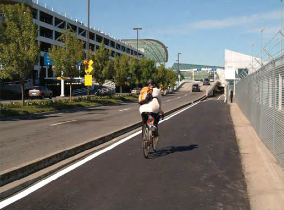
- – A multiuse path: The path connects to a regional trail system and continues all the way to the terminal (Figure 88).
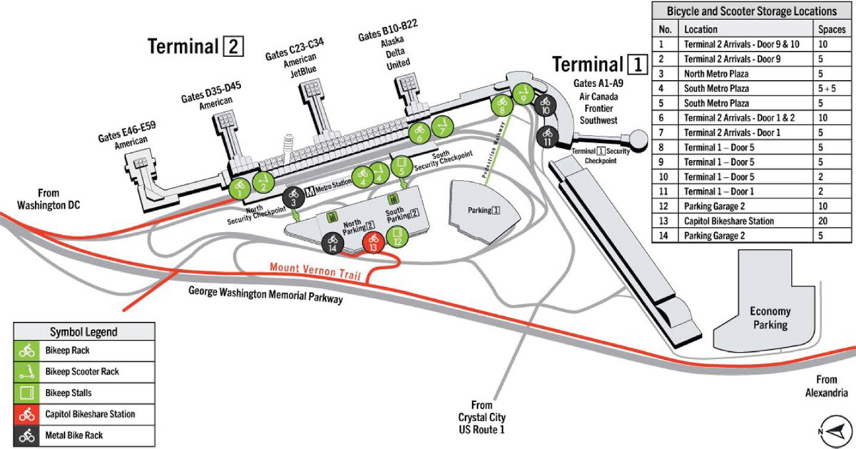
- Ronald Reagan Washington National Airport (DCA): Located near the Mount Vernon Trail, the airport offers bicycle facilities to airport guests and employees, including self-service bicycle storage racks available across the airport at no cost and on a first-come basis. In addition, an on-airport Capital Bikeshare station with 19 spaces exists where users can rent a bicycle. The station is located near the Mount Vernon Trail, providing easy access to nearby attractions, and is accessible through the airport parking garage (Figure 89).
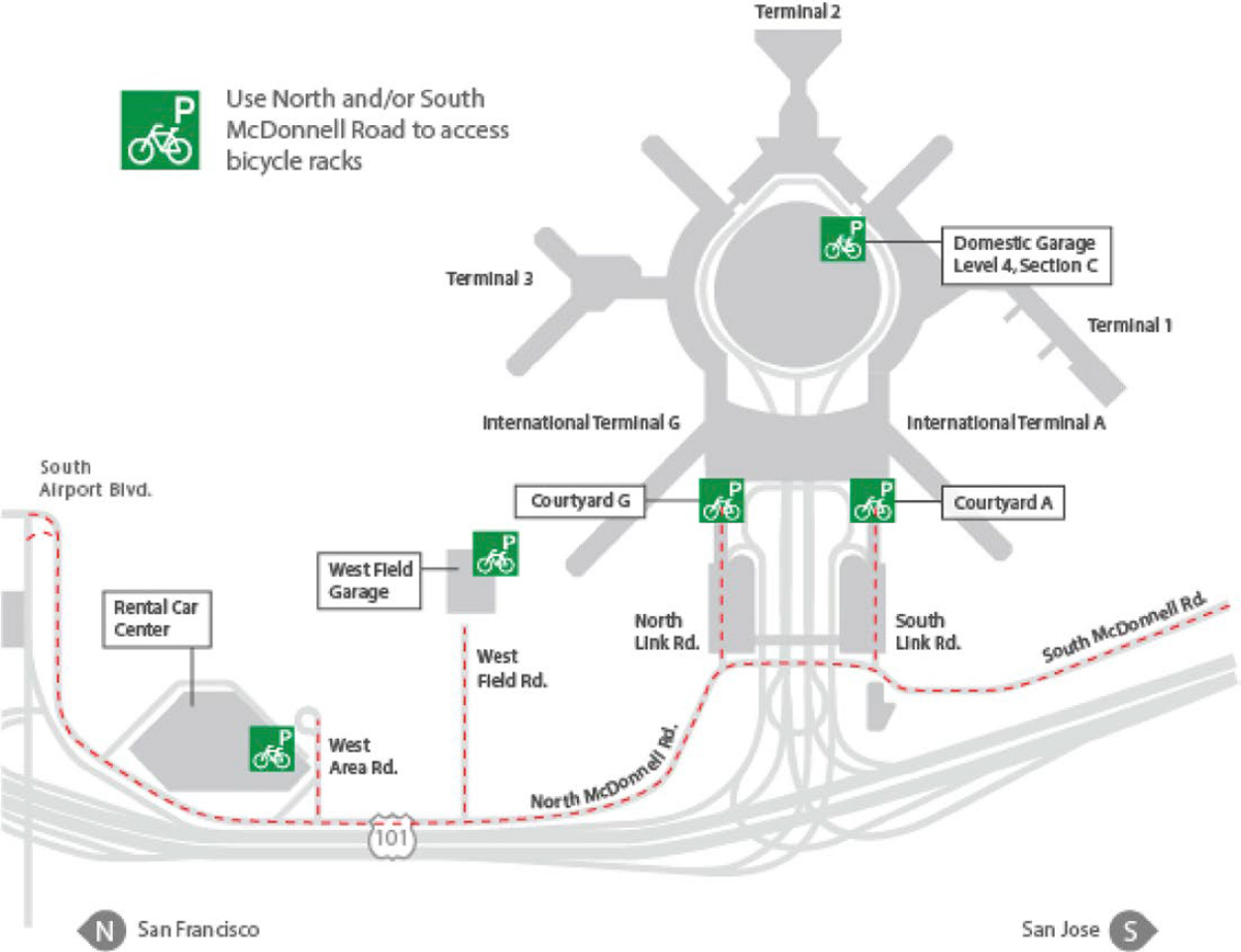
- San Francisco International Airport: SFO provides bicycle facilities for people accessing the airport by bike with a marked route into the airport, beginning at San Bruno Avenue from the north and Millbrae Avenue from the south, and they are prohibited from operating on the main inbound and outbound airport roadways (R1) (Figure 90). Bicyclists must comply with applicable California Vehicle Code (CVC) Laws related to bicycle use. SFO also offers a number of bicycle facilities, including
Source: Port of Portland (2014)
-
- – Bicycle assembly stations are located at the bicycle parking areas in International Terminal Courtyards A and G and the Rental Car Center for travelers to easily assemble or disassemble bikes before their flights. Airline-approved boxes for transporting bicycles are also available for purchase at the Airport Travel Agency.
- – Five courtesy bicycle parking areas provide bicycle racks at no charge for passengers and airport employees to store their bikes for up to 14 days. However, bikes parked for more than a day need to be registered.
Public Bus
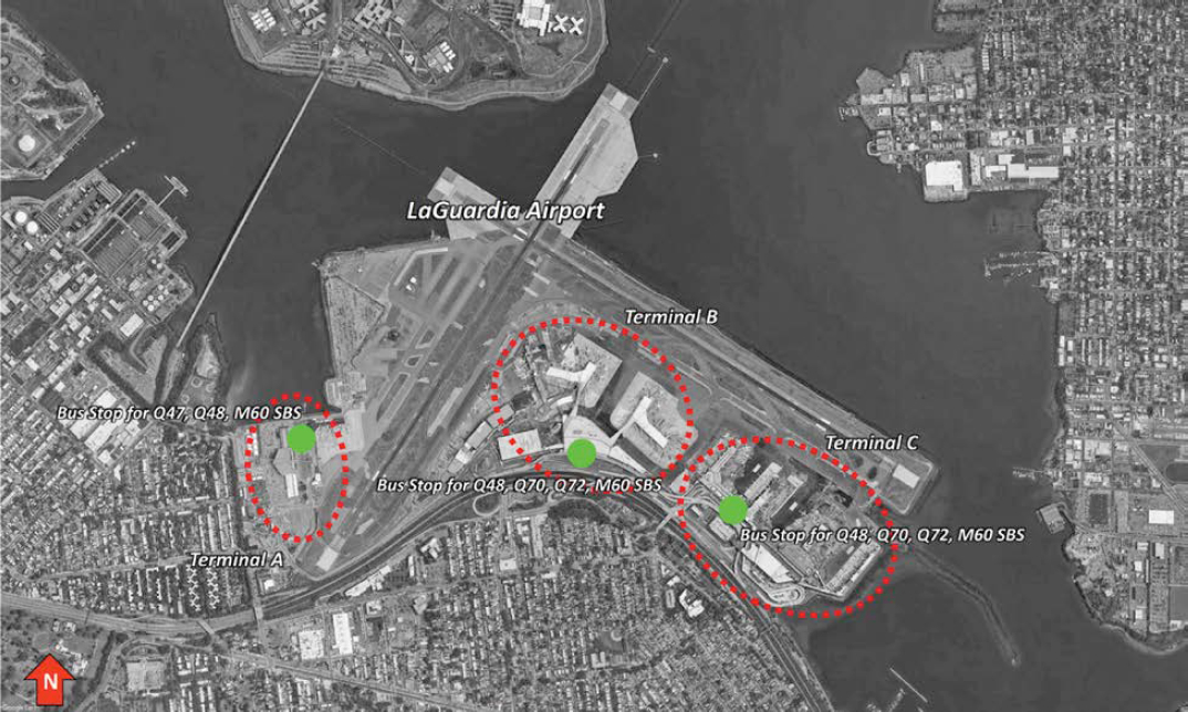
One of the most popular forms of public transportation at airports is buses. The transit authority of New York City, Metropolitan Transportation Authority (MTA), provides bus services all around the city, especially to LaGuardia Airport (LGA) and John F. Kennedy International Airport (JFK). The bus network is also connected to the subway and rail networks. At LGA, there are 6 regular buses connecting the three terminals to Manhattan and Queens (Figure 91). One-way ticket fare, like any MTA buses or subways, costs $2.75. Buses are operating every day with a connection every 20 minutes, and the service is not stopped for certain routes. At each terminal, the bus stops are located on the curb fronts at the departure levels.
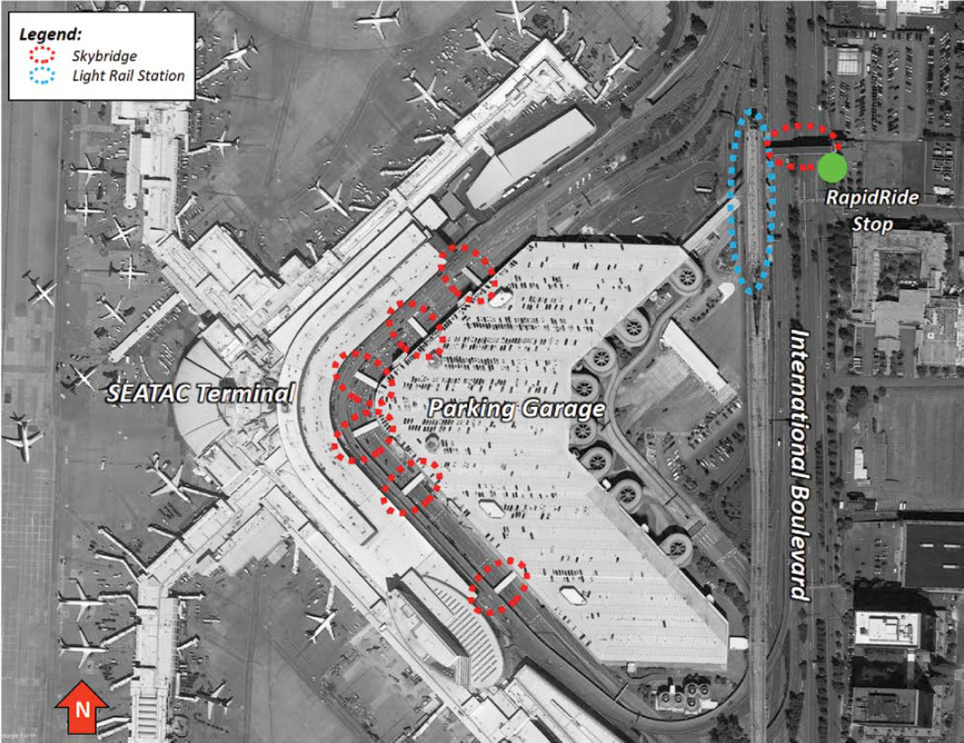
BRT networks are implemented at several airports across the country. King County Metro, the transit agency of King County, Washington, operates a BRT network of 6 routes, with two lines connecting southern cities of the county and Seattle to Seattle-Tacoma International Airport (SEA). The first route, A-Line, was implemented in 2010 and runs on a mix of dedicated lanes and mixed-traffic roadways along the state highway. The BRT line is in continuous service every day, with a connection every 10 minutes from 7 a.m. to 6 p.m. Frequency is lower after those hours. One-way adult fare costs $2.75. At SEA, the BRT stop is on International Boulevard, adjacent to the SEA Light Rail Station, as shown in Figure 92. Passengers have to cross the boulevard via a sky bridge to enter the SEA Light Rail Station, which is connected to the 4th floor of the parking garage. Then, passengers need to walk for around 10 minutes through skybridges to access the terminal area.
Source: Ronald Reagan Washington National Airport (2024)
At this date, there is no LSAV network at U.S. airports used as public transportation. However, several airports are considering such a transportation mode and have accommodated pilot tests. This was the case at Austin-Bergstrom International Airport, which tested an LSAV shuttle from the rental car facility to the terminal in 2019. This 6-month project evaluated the capabilities of an LSAV shuttle as a form of public transportation. The tested vehicle was an EasyMile EZ10Gen-1, capable of carrying 10 to 12 passengers.
Personal Rapid Transit
A few case examples of existing PRT systems are currently operational at airports. Additional examples of PRT systems that are not operating at airports are also provided below:
- Heathrow Airport, London, United Kingdom: A PRT system was constructed using the Urban Light Transit (Ultra) design and commissioned by Heathrow Airport Operator in 2011, consisting of 21 vehicles operating on a 2.4-mile route connecting Terminal 5 to the T5 Business Car Park. The Ultra pod system serves 800 passengers per day and operates at a design speed of 25 miles per hour (mph). The system capital cost was $40.1 million. In addition, waiting time for PRT users is less than 30 seconds, which achieves great level of service.
- Greenville-Spartanburg International Airport in South Carolina: A prefeasibility study was conducted in 2015 with a subsequent financial study currently in process for a PRT solution to link the parking lots to the terminal initially, with the provision to be expanded into other areas for a hotel, etc.
- Norman Y. Mineta San José International Airport (SJC), California: The airport conducted a preliminary feasibility study for an extensive PRT system to connect the airport to Diridon Station in the west end of San José’s Downtown and is now undergoing procurement.
Heavy Rail
Some metropolitan areas with heavy rail systems in the United States have extended them to the airports that serve them. WMATA’s Blue and Yellow metro line services stop at Ronald Reagan Washington National Airport in Arlington, allowing travelers to access most of Downtown Washington, DC (Metropolitan Washington Airports Authority 2021). The Metrorail station is located on a dedicated structure between the passenger terminal and the parking garages; these three structures are connected through twin elevated walkways between the departure and arrival levels, as depicted in Figure 93. Trips to DCA are not subject to an airport-specific charge—Metrorail pricing is instead defined by both the distance traveled and whether the trip takes place during peak or off-peak hours.
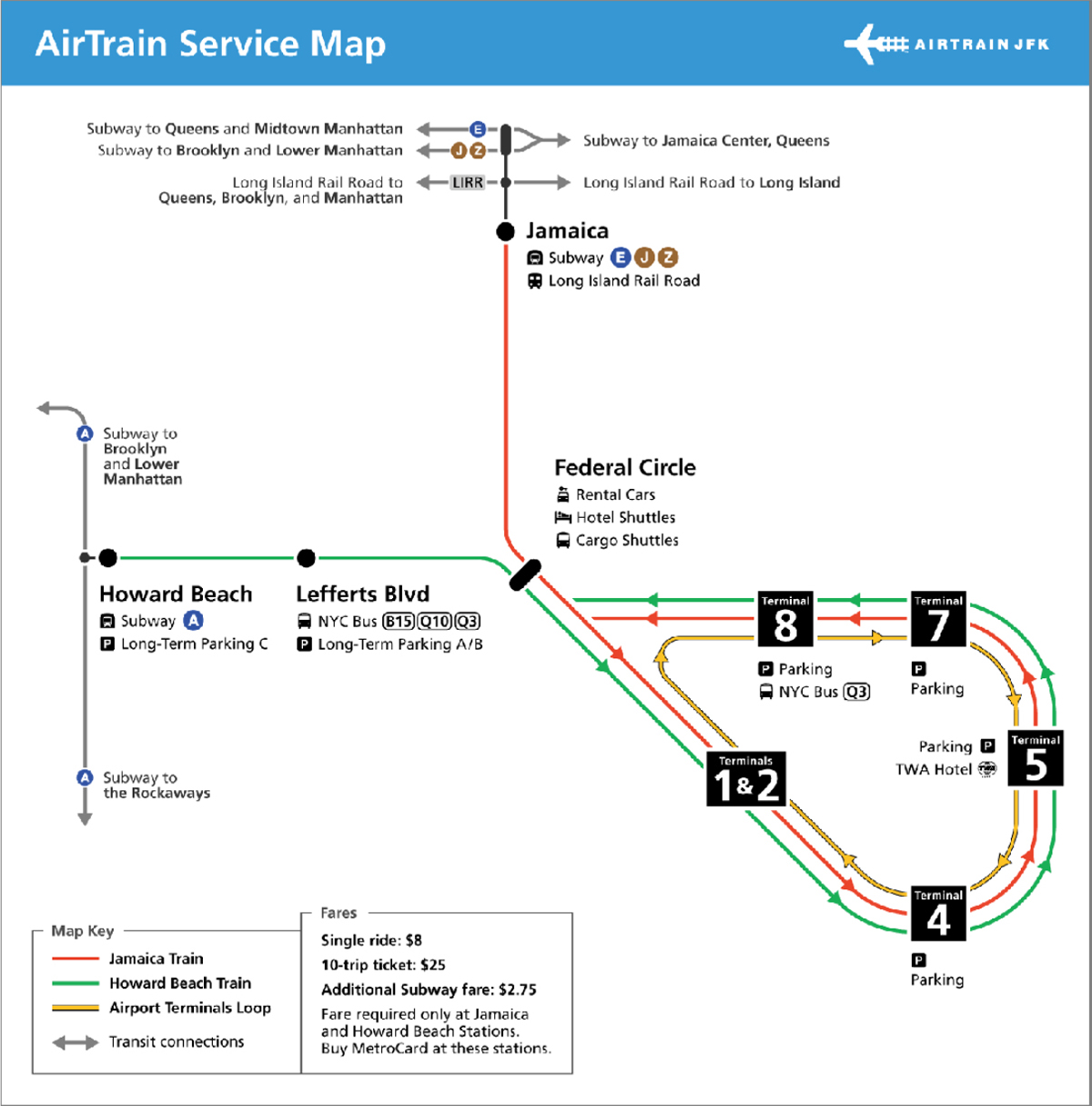
Heavy rail may also be a part of a multimodal strategy for airport ground access. Access to JFK in New York City is possible by traveling by subway to either the Jamaica (north) or Howard Beach (west) stations and then transferring to the AirTrain automated people mover (APM) toward the airport’s terminals (Figure 94). While the subway charges a $2.75 flat fare throughout its network, access to/from the AirTrain from subway stations requires an additional $8 fee, but usage of the AirTrain between the airport’s facilities is free (John F. Kennedy International Airport 2022).
Light Rail
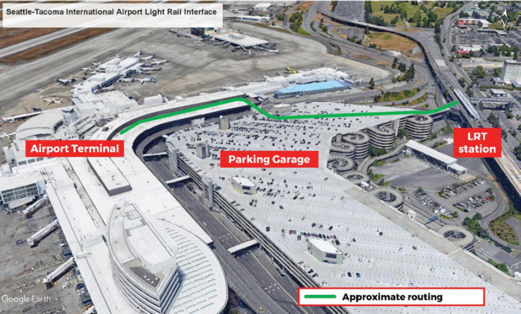
Light rail permits access to multiple airports in the United States. Seattle-Tacoma Airport is served by Sound Transit’s 1 Line, with the station connected to the airport’s terminal through the parking garage and a series of elevated walkways (Port of Seattle 2020)—this interface is

Source: Google Earth, retrieved 2021
depicted in Figure 95. Service to/from the airport does not incur an airport-specific surcharge. Instead, Sound Transit fares are calculated regarding distance traveled—a trip to/from the airport may cost between $2.25 and $3.50 at standard adult fares (Sound Transit 2022).
Pedestrian access between airports and their light rail stations may not be possible at all locations, such as at Los Angeles International Airport (LAX). Current access to LAX occurs through the C Line at the Aviation/LAX station, southeast of the terminal complex—the airport provides a free shuttle bus service between the arrivals area at the airport and the light rail transit (LRT) station (Los Angeles International Airport n.d.). This is a provisional solution for light rail ground access, as simultaneous development of the Crenshaw/LAX transit project and the LAX APM—both shown in Figure 96—will expedite access to the airport (LA Metro n.d.).
Commuter Rail
Commuter rail can provide access to airports that are further away from city centers than those served by heavy or light rail. Baltimore/Washington International Thurgood Marshall Airport, which lies between Baltimore and Washington and has become a focus city for low-cost carriers, can be accessed through the MARC commuter rail system, as neither the Baltimore Metro SubwayLink nor WMATA’s Metrorail ranges extend to that location. Passengers can reach the airport through trains departing from Washington’s Union Station and Baltimore’s Penn Station by paying a distance-based fare, with a premium being levied during peak hours. Access between the commuter rail station and the airports’ terminals is provided as a free bus shuttle operated by the airport.
Tri-Rail in South Florida is a unique example for airport ground access. Not only does it link three different airports within a single line, but access between each airport and its corresponding
Source: John F. Kennedy International Airport (2022)
Source: Google Earth, retrieved 2020
station is complemented by different modalities. At Miami International Airport, the Tri-Rail stops at the airport’s ground transportation center, where passengers may ride an APM to the terminal; at Fort Lauderdale, a complimentary bus service connects passengers to/from the terminals. The Palm Beach connectivity example goes a step forward, offering passengers a free Uber ride between the rail station and a specific area around it that includes the airport.
Intercity/High-Speed Rail
Currently, the only existing example of intercity rail or high-speed rail connecting with air transportation is Amtrak. There are five direct air-to-rail connections in existence in the United States since Florida’s Brightline recently opened the MCO station in 2023. Included in this section are examples of intermodality between intercity rail or high-speed rail and access to or egress from an airport. Not all examples are direct air-rail connections, and some feature multiple modes of transit connecting intercity/high-speed rail with airports.
-
Existing connections:
- – The Amtrak Acela (high-speed rail) connects with a few airports along the Northeast Corridor either directly or intermodally:
- Baltimore/Washington International Thurgood Marshall Airport (BWI): The train arrives at a train station near the airport (Figure 97). A 24-hour shuttle is available to take passengers to BWI terminals after arriving at the train station. The shuttle operates every 10 minutes, except for the hours between 1 a.m. and 5 a.m. where it runs every 25 minutes. The shuttle stops at each terminal for arrivals and at four designated stops outside of baggage claim to return to the Amtrak station. At the Amtrak station, the shuttle stops outside the rail station garage, directly across from the rail station (Baltimore/Washington International Thurgood Marshall Airport n.d.).
- – The Amtrak Acela (high-speed rail) connects with a few airports along the Northeast Corridor either directly or intermodally:

Source: LA Metro (2022)
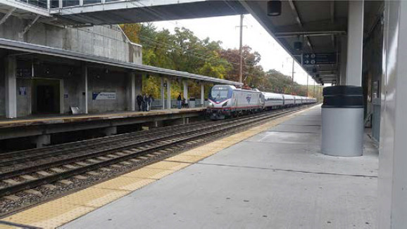
Source: Photo by Charles Fulton, 2015
-
-
- Philadelphia International Airport (PHL): The Amtrak station (30th Street Station) in Philadelphia is a shared station with the regional rail line via Southeastern Pennsylvania Transportation Authority (SEPTA). The SEPTA Airport Regional Rail Line goes directly to PHL, with stops at Terminal E/F, Terminal C/D, Terminal B, and Terminal A (East).
- Rhode Island T. F. Green Airport: Similar to PHL, a commuter rail line (MBTA) connects to Amtrak at a shared station (Providence Station). Passengers can travel to or from the airport using Amtrak and the MBTA commuter rail.
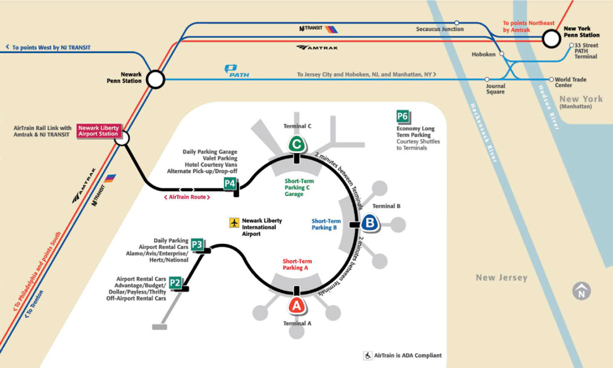
- Newark Liberty International Airport (EWR): Amtrak connects to EWR at a shared station with EWR’s AirTrain (APM) to provide an intermodal transfer point for the final segment of the journey to/from the airport (Figure 98).
- – Amtrak intercity (non-high-speed rail) air-rail connections:
- Mitchell International Airport: The Milwaukee Airport Rail Station provides air-rail connections for passengers traveling on Amtrak’s Hiawatha line. Passengers can connect to or from the airport terminal from the rail station by using a free shuttle bus.
- Hollywood Burbank Airport (BUR): Amtrak shares an airport station with Metrolink commuter rail; however, the Amtrak station is a direct air-rail link and does not require transferring to a different mode once at the station. The passenger-rail service is provided by Amtrak’s Pacific Surfliner and stops at the station five times daily. Access to/from the rail station and the terminal is possible by walking or airport shuttle (Sperry et al. 2012).
- – Brightline Florida: The Miami terminus connects passengers to Downtown Miami with convenient connections to multiple mass transit options, including commuter rail (Metrorail), APM (Metromover), bus (Metrobus), and trolley (Miami Trolley). The Miami Metrorail Orange Line connects directly to the Miami International Airport (MIA) at one end of the line, thereby providing a multimodal transportation option for passengers traveling to or from Miami and other parts of Florida. The Orlando terminus recently constructed at Orlando International Airport (MCO) with service opened in 2023.
-
-
Future connections:
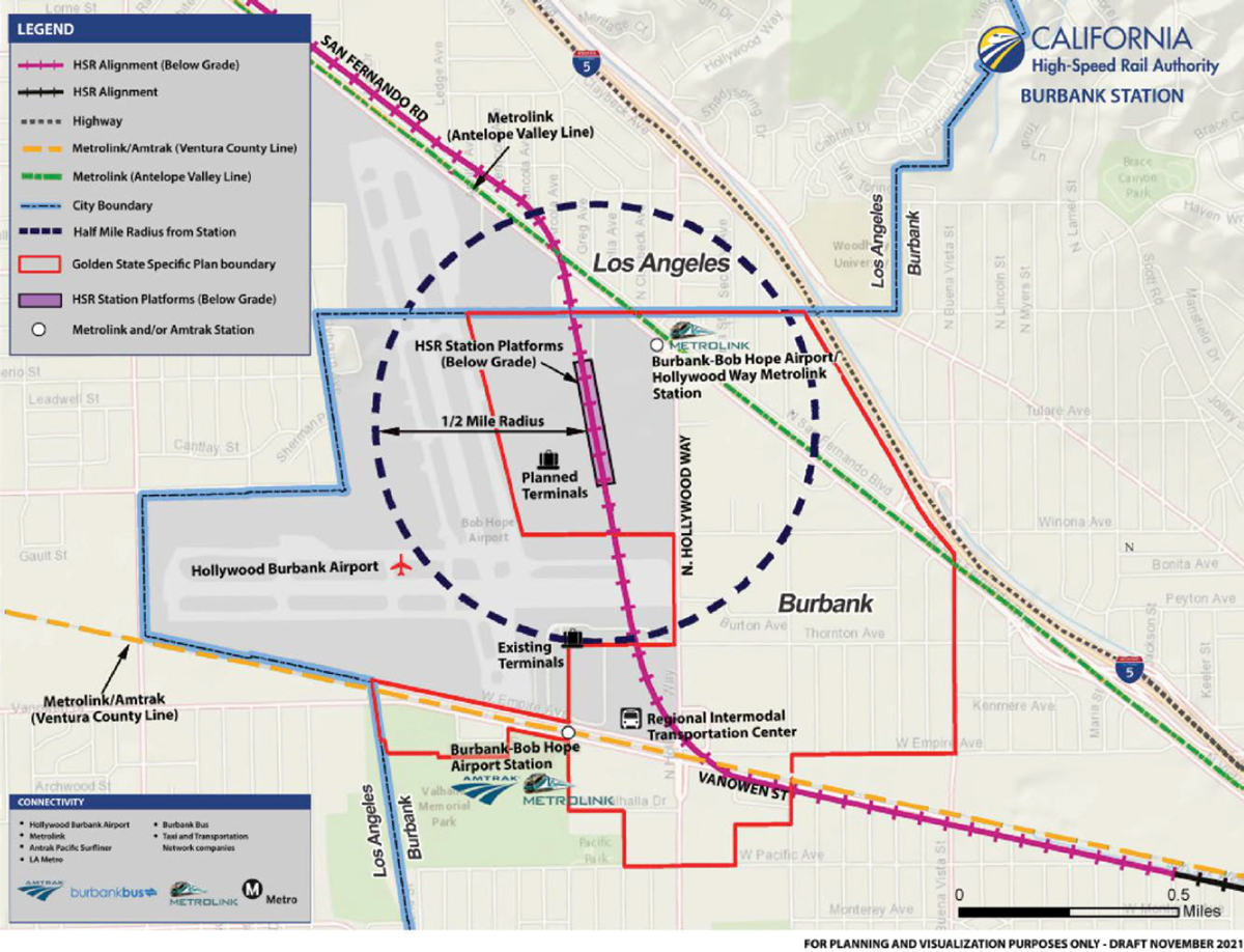
- – California High-Speed Rail: California High-Speed Rail is planning a station at Hollywood Burbank Airport (BUR) which will be an underground station, adjacent to the future BUR replacement terminal (Figure 99). As of January 2022, the Board of Directors approved the certification of the Burbank to Los Angeles Environmental Impact Statement (EIS)/ Environmental Impact Report which includes the plans for the BUR station (California High-Speed Rail Authority 2021).
Source: Newark Liberty International Airport (2022)
Source: California High-Speed Rail Authority (2021)
Vactrain/Hyperloop
Hyperloop systems, though in the initial stages, have been considered by some states as a transit solution to connect airports with other regions. Some examples of potential U.S. airports are as follows:
- Norman Y. Mineta San José International Airport, California: The San José Department of Transportation is looking into connecting the Diridon Station, which is projected to be the busiest transportation hub on the West Coast, to the Norman Y. Mineta San José International Airport. The hyperloop system was considered since the goal was to connect the two stations in the fastest possible way. Virgin Hyperloop believes a connection between these two stations will take 3 minutes or less.
- Denver International Airport, Colorado: As part of the ultimate plan of developing a hyperloop facility and route through the Front Range Urban Corridor, the Colorado Department of Transportation partnered with AECOM, the City of Greeley, the City and County of Denver, and Denver International Airport to put plans in place for an accelerated phase 1 of the project. Phase 1 encompasses a hyperloop hub at the Denver International Airport that connects to the City of Greely via a 40-mile (64-kilometer) route.
- John Glenn Columbus International Airport (CMH), Ohio: The Mid-Ohio Regional Planning Commission conducted a feasibility study to determine the feasibility of a tristate corridor connecting Chicago, Illinois; Columbus, Ohio; and Pittsburgh, Pennsylvania. As part of the first phase, the Mid-Ohio Regional Planning Commission consulted with the Ohio Department of Transportation, the Ohio Rail Development Commission, and Virgin Hyperloop on a plan to connect the John Glenn Columbus International Airport to Downtown Columbus and the City of Dublin. The connection between the cities and the airport is believed to take 2 minutes or less.
Outside of the United States, other countries have shown interest in integrating hyperloop systems with their various airports as well.
- Kempegowda International Airport Bengaluru (BLR), India: Virgin Hyperloop partnered with the operator (BIAL) to conduct a feasibility study on a hyperloop corridor from the airport to the city center with a goal of making the airport a transportation hub. The proposed hyperloop connection from the airport to the city center is believed to have a travel time of 2 minutes or less.
Maglev technology uses electromagnets to levitate and propel a train or pod, thereby reducing friction to zero and creating a faster mode of transportation. Maglev was developed in the United States in the 1960s and is similar to how hyperloop pods are anticipated to be propelled through the tubes. Since the inception of this technology, there have been proposed projects to incorporate the system into airports as an additional mode of transport in the United States. Some of the proposed maglev projects connecting to airports are:
- Baltimore/Washington International Thurgood Marshall Airport (BWI): The Baltimore-Washington Maglev project is a proposed 39.1-mile (62.9 km) maglev corridor connecting Baltimore’s Camden Yards to Amtrak’s Union Station in Washington. This connection will have an intermediate stop at the Baltimore/Washington International Thurgood Marshall Airport with the goal of providing residents and visitors of Washington, DC, with a second airport that is equally fast to get to, thus relieving the pressure off Ronald Reagan Washington National Airport.
- Pittsburgh International Airport (PIT): The Pittsburgh Maglev project is a proposed 55-mile (89 km) maglev corridor linking PIT to downtown Pittsburgh and further along to Greensburg. The connection time from the airport to Greensburg is projected to be 35 minutes long. The Port Authority of Allegheny County is leading the project in collaboration with Maglev Inc.
- Las Vegas-Anaheim: The Las Vegas-Anaheim Maglev project is a proposed 269-mile (433 km) maglev corridor that connects Las Vegas, Nevada, to Anaheim, California. The project includes six stations, with a proposed station at the forthcoming Ivanpah Valley Airport in Nevada and a station at a regional airport in Victorville, California.
Maglev has international recognition, with some countries having a fully functional maglev transport system. Japan, Korea and China have operational systems, while other countries, like India, are still in the proposal stages. Two examples of operating maglev systems are provided below and include connections to airports.
- Incheon International Airport (ICN), South Korea: As part of the Korean Urban Maglev Program, the Incheon Airport Maglev line was developed. It is 3.8 miles (6.1 km) long, starting from Incheon Airport. The line has six connecting stations including to the airport’s long-term parking lot. It is provided as a free service and runs every 15 minutes.
- Shanghai Pudong International Airport (PVG), China: The Shanghai maglev train is a high-speed maglev train with a cruising speed of 268 miles per hour (431 km/h), operating on a 19-mile (31 km) line. The line starts from Shanghai Pudong International Airport and connects to the outskirts of the city. The travel time for the full journey is approximately 8 minutes.
Aerial Cableway Transportation
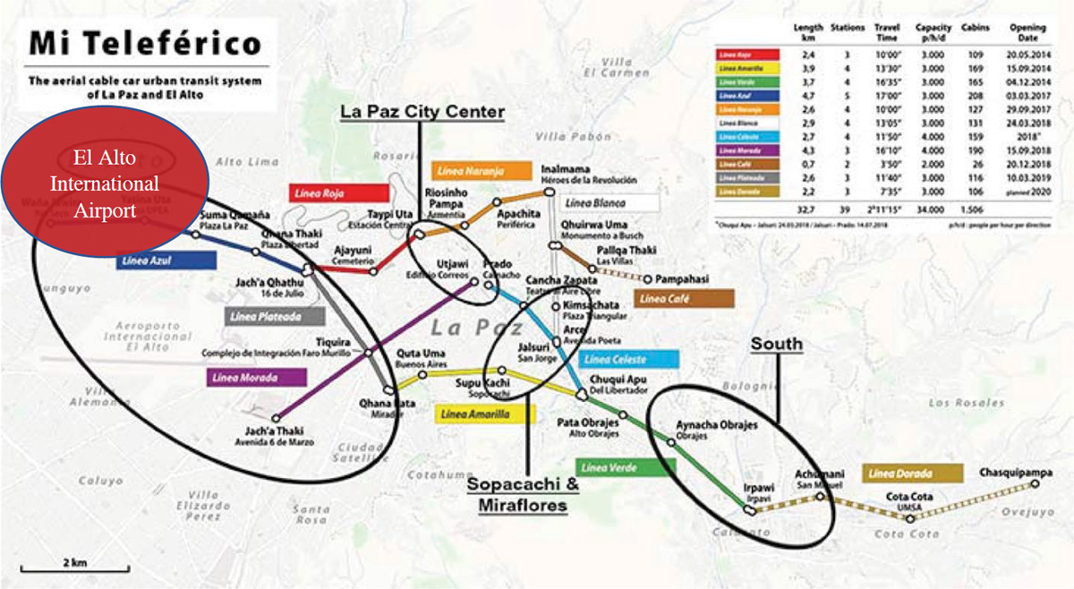
As of today, there are no airports with direct connection with aerial cableway transportation. In La Paz, Bolivia, passengers can travel to the airport using the public transportation network, which includes these cable cars. Figure 100 shows the routes that are available for passengers from the airport to the city. Implementing this mode of transportation at an airport could be promising. A cableway system could move 2,400 p/h/d (passengers per hour per direction), greater than a three-car LRT system running at 15-minute intervals, which could carry an estimated 1,800 passengers at the same time. This system lowers the risk of delays for passengers arriving through this system and increases overall efficiency. The entire structure can operate using a single electric 500-horsepower motor, which could reduce greenhouse gas (GHG) emissions compared to other transportation modes. Cabins provide level boarding to meet ADA requirements and to enable boarding and alighting for passengers with mobility devices. Boarding the gondolas is easy, even in a large power wheelchair. Station staff will fold up one or both seats inside the car to make room, and they can slow (or stop) the gondola’s movement to ensure a safe boarding process. In addition, the minimal footprint required to operate the skyway could result in reduced right-of-way impacts and less impact on sensitive habitats compared to different modes.
There have already been successful implementations of these cableways in the urban context in the United States, including the Portland Aerial Tram (Portland, Oregon) and the Roosevelt Island Tram (New York, New York). Interest in aerial cableway technology has grown considerably in the United States in recent years. Initial feasibility studies have been completed in other U.S. cities, including San Diego, California; Washington, DC; and Brooklyn, New York.
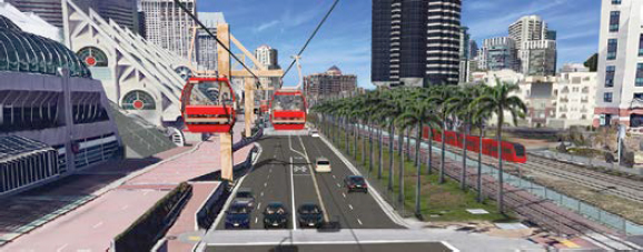
The San Diego International Airport could be the first airport-based aerial cableway system in the U.S., as the County of San Diego officials weigh the possibility of introducing gondolas as an alternative to rail or private vehicle transportation. A study by WSP (2018) evaluated the feasibility of building an aerial cableway system between the San Diego Convention Center and San Diego International Airport, the busiest single-runway airport in the United States (Figure 101).
The San Diego International Airport has a desire for growth, and they are looking for the opportunity to integrate a cableway station with the design of the new terminal. The study involved evaluating potential alternatives, ridership, and capital and operating & maintenance (O&M) costs.
Source: WSP (2018)
Urban aerial cableways could gain more attention as a convenient and economical people mover that provides economic benefits. It allows the potential of growth even within constrained environments or where a cableway could extend existing transit lines.
Waterway Transportation
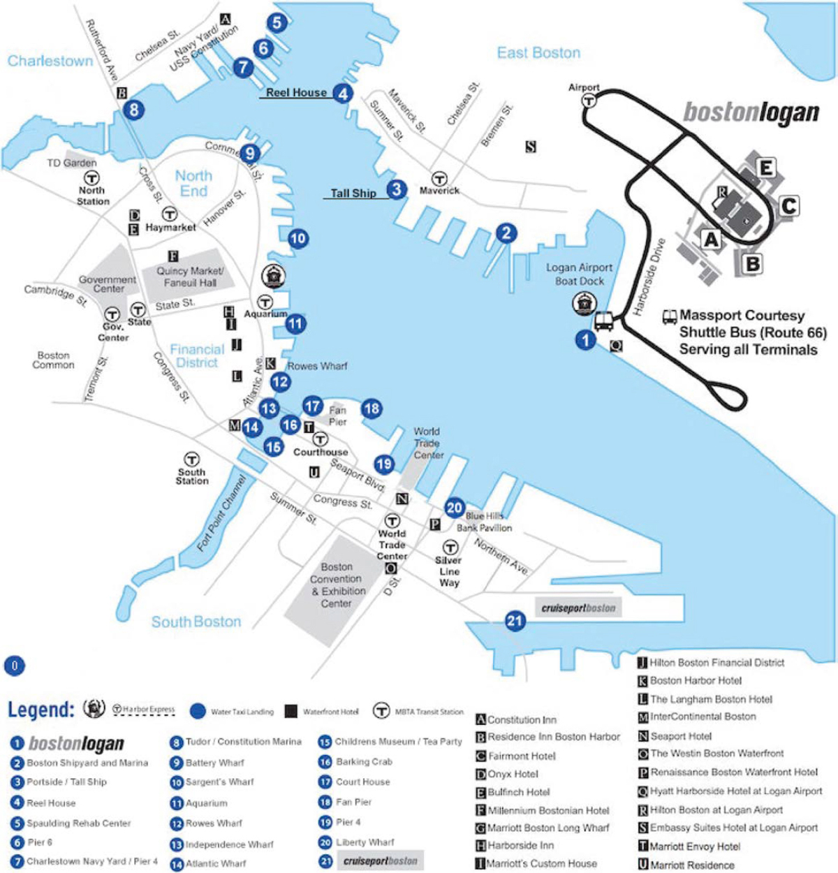
Although it is rare to see airports connected by water transportation, two U.S. exceptions should be noted. The first one is at Boston Logan International Airport, served by private water taxis and offering on-demand services to the entire Boston waterfront at 25 locations, as depicted in Figure 102. The boat dock is located southeast of the airport, near the Hyatt Regency Hotel. Boston Water Taxi operates seven days a week, from 8 a.m. to 8 p.m. Several ticket types are available, ranging from $10 to $45: one-way, child one-way, one-way plus luggage storage, and roundtrip plus luggage storage. To connect passengers from and to the terminals, a free airport shuttle is provided. Boston Water Taxi has two types of vessels with a passenger capacity ranging from 20 to 25 passengers.
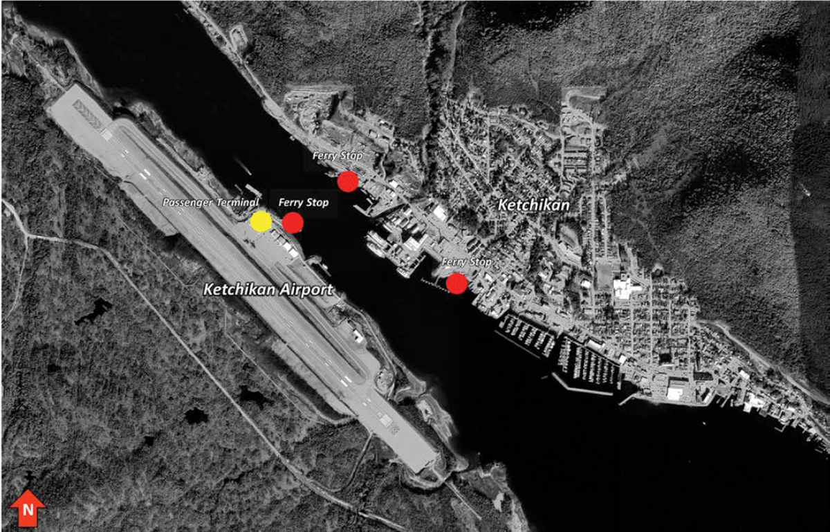
The second airport example is Ketchikan International Airport in Alaska, located on Gravina Island and accessible only by ferry from the city (Figure 103). The ferries operate every day from 6:15 a.m. to 9:30 p.m., and they leave the city on the quarter hour and the airport side on the hour and half hour. Passenger fares costs $6 for a one-way trip but can be used as a return trip if used the same day. The ferries can also transport vehicles, with fares ranging from $3 to $38. When passengers are disembarking ferries on Gravina Island, a canopy connects the docking area to the passenger terminal.
Multimodal Integration at Commercial Service Airports
A benefit of increasing the ground access options at an airport is that the airport itself can become a multimodal hub; this is being observed through landside renovation/renewal projects. These multimodal hubs can be either standalone facilities or be integrated into the airport’s terminals or existing landside development (such as parking structures). Multimodal facilities at airports currently tend to be served by bus and rail services, but planning for emerging technologies, such as advanced air mobility, is becoming possible as these technologies mature. The availability and integration of different modes of transport ultimately depend on the airport and regional transport strategies:
- LAX Landside Access Modernization Program (Los Angeles, CA) is currently underway and strives to both reduce traffic congestion caused by private vehicle pick-ups and drop-offs around the terminal complex and enhance ground access options at LAX. Los Angeles World
Source: Boston Water Taxi (2022)
- Airports (LAWA) is developing two remote “Intermodal Transportation Facilities” with options for transportation network companies (TNCs) and private vehicles to pick-up and drop-off passengers, as well as bus and rail access. An APM is also provided to connect these facilities with the airport terminals.
- MCO South Terminal Complex (Orlando, FL) is a novel terminal concept in the United States that incorporates both an airport terminal, vehicle parking, intra-airport mobility (via APM), and high-speed rail access within walking distance of each other. This greenfield project hosts the ultimate terminus of Florida’s Brightline private high-speed rail line.
- LGA Landside Redevelopment (New York, NY) is being conducted parallel to but closely coordinated with the redevelopment of Terminals B, C, and D. This project would consolidate the airport’s ground access options into a single facility that would host parking, taxi ranks, and TNC pick-up and drop-off spots. Plans to integrate an APM system connecting LGA to the New York City Subway were underway but have since been discontinued.


