Roadside Encroachment Database and Analysis (2025)
Chapter: Appendix C: Coding and Analytical User's Manual
Appendix C
Coding and Analytical User’s Manual
Luke E. Riexinger
Virginia Tech
Blacksburg, VA
Douglas J Gabauer
Bucknell University
Lewisburg, PA
September 30, 2023
Table of Contents
Encroachment Types and Associated Road Edge Nomenclature
Methods to Populate the 17-88 ED
17-88 ED Inclusion Criteria by Data Source
State Crash and Maintenance Data
Iowa State Representative Routes and Data
Washington State Representative Routes and Data
Tennessee State Representative Routes and Data
Motorcycle Crash Causation Data
NCHRP 22-26 Project In-Depth Motorcycle-Barrier Crash Cases
NCHRP 17-88 Database Structure
Linking Information and Primary Key Information
Primary Sampling Unit, Case Number
Involvement of Another Vehicle
Introduction
Run-off-road traffic crashes account for almost one third of the deaths and serious injuries each year on U.S. highways (Kusano and Gabler 2014). The effective design of roadsides, including the placement of roadside safety devices, can reduce the severity of these crashes but requires an understanding of the nature and frequency of roadside encroachments. Current roadside design practices are based on a relatively limited amount of roadside encroachment data collected more than 40 years ago and focused primarily on passenger vehicles. The objective of National Cooperative Highway Research Program (NCHRP) Project 17-88 was to (1) develop a database of roadside encroachment characteristics for a variety of roadside conditions and roadway types, and (2) analyze the database to evaluate (a) the factors that influence the nature and frequency of roadside encroachments, (b) the relationship between unreported and reported crashes, and (c) whether heavy vehicle, bus, and motorcycle encroachments differ from passenger vehicle encroachments resulting in a crash.
The purpose of this coding manual is to provide a synopsis of the data sources used to populate the NCHRP Project 17-88 encroachment database (17-88 ED), define the specific data elements and associated attributes available in the 17-88 ED, and provide information on how the 17-88 ED data elements were collected from each of the existing encroachment data sources.
Encroachment Types and Associated Road Edge Nomenclature
The 17-88 ED contains encroachments across the full range of highway vehicle types, including passenger vehicles, heavy vehicles, and motorcycles, along with the entire spectrum of encroachment severities. As shown in Figure 1, roadside encroachments can be broadly grouped into three severity categories: (a) encroachment without collision, (b) encroachments with unreported collisions, and (c) encroachments with police-reported collisions.

Recent roadside safety research has also classified encroachments into four categories based on vehicle initial travel direction and departure side (Carrigan and Ray 2018). Vehicles leaving the right side of a divided or undivided roadway are denoted as primary right (PR) if traveling in the direction of increasing mileposts or opposing right (OR) if traveling in the direction of decreasing mileposts. Similarly, left encroachments are also denoted as primary left (PL) or opposing left (OL).
A specific roadway section would have either two or four possible departure edges, depending on roadway type (i.e., divided or undivided). Divided roadways would have four possible edges:
- Primary right edge (PRE)
- Primary left edge (PLE)
- Opposing right edge (ORE)
- Opposing left edge (OLE)
For undivided roadways, the OLE and PLE are coincident (i.e., the road centerline) and do not represent a road edge, as a vehicle could depart the lane and still remain within the traveled way. This leaves two possible edges, PRE and ORE, for undivided roadways (Figure 2).
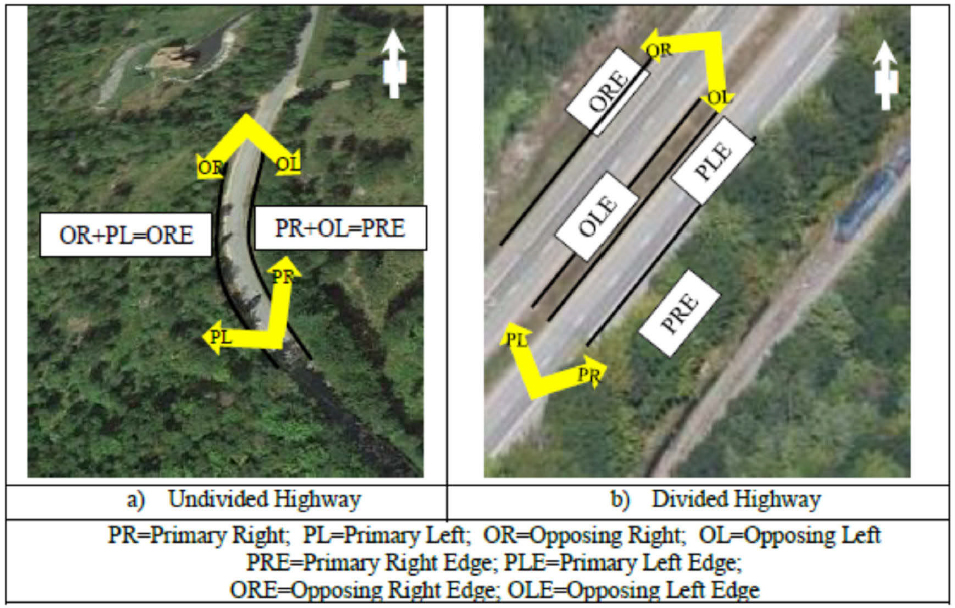
For the purposes of the 17-88 ED, an encroachment is defined as any vehicle crossing the PRE or ORE on an undivided roadway or crossing any of the four edges—PRE, PLE, OLE, or ORE—of a divided roadway. While encroachments may primarily involve a single vehicle leaving the roadway, an encroachment can also occur during a multi-vehicle crash (e.g., a vehicle strikes another vehicle prior to crossing one of the road edges noted above).
Encroachment Data Sources
To capture information about different encroachment severities and different highway vehicle types, the 17-88 ED is comprised of encroachments collected from several different U.S.-based sources, primarily crash databases. A synthesis of data from different sources is required to
develop the 17-88 ED, as no one existing data source provides all the encroachment-related information required to fulfill the objectives of the project.
The data sources used to populate the 17-88 ED are described briefly below:
- Second Strategic Highway Research Program (SHRP2) Naturalistic Driving Study (NDS) and Roadway Information Database (RID). The SHRP 2 NDS was a recent NDS led by the Transportation Research Board of the National Academies of Science (Dingus et al. 2015). In SHRP 2, over 3,300 private vehicles were equipped with cameras, radars, and other sensors to collect over 3 years of data, including a total of 6,650,519 trips and nearly 50 million miles of driving. The SHRP 2 NDS captured a substantial number of roadside encroachments, both with and without collisions.
The SHRP 2 dataset includes a second supplemental database of the roadway characteristics that can be linked by event location to each SHRP 2 encroachment discussed above. This linkage allows the determination of the effects of roadway characteristics on the nature and frequency of roadside encroachments. Data elements in the RID include horizontal curvature (radius, length, and direction of curve, i.e., left or right), vertical grade, cross-slope/super-elevation, lane configuration (number, width, and type, e.g., turn or acceleration lanes), shoulder type, presence of curb, presence of longitudinal barriers (e.g., guardrails), and presence of rumble strips.
The SHRP 2 NDS/RID data can be used to primarily characterize passenger vehicle encroachments that do not result in any collision, unreported or police reported. To a lesser extent, the SHRP 2 NDS/RID data can be used to investigate passenger vehicle encroachments resulting in a collision across the range of severities, from minor unreported crashes to more serious police-reported collisions following an encroachment.
NCHRP 17-43 Road Departure Database. The NCHRP 17-43 database is comprised of 1,581 police-reported road departures extracted from the National Automotive Sampling System/Crashworthiness Data System (NASS/CDS) for years 2011 to 2015. NCHRP 17-43 contains full reconstructions and trajectories for these cases through analysis of CDS crash scene diagrams and scene photos recorded by the NASS/CDS crash investigator (Riexinger and Gabler 2020). The NCHRP 17-43 dataset can be used to determine characteristics of encroachments resulting in a police-reported crash for passenger vehicles.
- State Crash and Maintenance Data. Police-reported crash data, roadside inventory files, and roadside hardware maintenance files for three states, Iowa, Washington, and Tennessee, were examined to provide encroachments to further populate the 17-88 ED. The crash data provides the frequency and severity of encroachments that resulted in a collision or rollover for all vehicle types. When linked with the inventory and crash data, the maintenance data can provide the frequency of crashes that required repairs but were not reported to police. Unlike the other datasets, the availability of roadway characteristic information across the network of state-maintained roadways allowed selection of a sample of roadways in each of the three states that ensured a variety of roadway conditions.
The state data can be used to determine unreported and police-reported encroachment frequency and characteristics across all vehicle types.
- Motorcycle Crash Causation Study (MCCS) and NCHRP Project 22-26 In-Depth Motorcycle-Barrier Crashes. The FHWA MCCS is the most recent comprehensive data collection effort investigating the causes of U.S. motorcycle crashes (Nazemetz et al. 2019). The MCCS database is comprised of 351 on-scene crash investigations and 702 control cases collected from case years 2011 to 2016 in Orange County, CA. For crash cases, investigations were conducted by experienced motorcycle crash data collection experts and included interviews of crash-involved parties and collection of crash, environmental, and injury data. Control cases were comprised only of characteristics of non-crash involved motorcycle riders and passengers based on interviews of motorcyclists passing the crash location at a later date but under similar conditions. As the MCCS includes all types of motorcycle crashes, only the MCCS cases involving encroachment are considered for inclusion in the 17-88 ED.
NCHRP Project 22-26 was tasked with identifying factors that contribute to serious and fatal injury in motorcycle collisions with traffic barriers (Gabler et al. 2021). As part of the research effort, the research team collected in-depth crash data and detailed rider injury data for 21 motorcycle-barrier crashes where at least one of the riders was admitted to a Level 1 trauma center. All the crashes occurred between years 2010 to 2016, inclusive, and took place at the Wake Forest University catchment area in either North Carolina or Virginia. All NCHRP 22-26 in-depth crashes involved an impact with a barrier situated outside the traveled way, so each NCHRP 22-26 case can be considered for inclusion in the 17-88 ED.
The MCCS and NCHRP 22-26 cases can be used to determine characteristics of encroachments resulting in a police-reported crash involving a motorcycle.
- Large Truck Crash Causation Study (LTCCS). The LTCCS provides detailed information for approximately 1,000 large truck crashes that occurred in the U.S. between 2001 and 2003 (FMCSA et al. 2006). The heavy vehicles included in LTCCS include both single-unit and multiple-unit (e.g., tractor trailer) type vehicles, all with gross vehicle weight in excess of 10,000 pounds. Similar to the NCHRP 17-43 database, the available scene diagrams and information collected by the LTCSS researchers provide the ability to determine the vehicle trajectory for each case. Similar to MCCS, the LTCCS includes all types of heavy vehicle crashes. Only the subset of LTCCS cases involving encroachment was considered for inclusion in the 17-88 ED.
The LTCCS can be used to determine characteristics of encroachments resulting in a police-reported crash for heavy vehicles.
Each source database contains data from potentially different time periods. Table 1 presents the time frames of the source databases used to populate the 17-88 ED and shows the coverage of the vehicle type and encroachment severity coverage associated with each data source. As previously discussed, note that the state datasets are the only source data that allowed for a direct control of the included roadway types. The in-depth studies (NCHRP 17-43, MCCS, NCHRP 22-26, and LTCCS) selected cases based on crash characteristics irrespective of roadway and/or roadside characteristics. Similarly, the SHRP 2 data are limited to the roadways that the study participants traveled during the study period. While there will be variation in roadway and roadside characteristics for the in-depth database and SHRP 2 cases, the variation in these cases is dictated solely by the available cases. For the state datasets, however, a sample of state-maintained routes
within in each state was selected to ensure a breadth of roadway types and associated characteristics.
Table 1. NCHRP 17-88 Data Source Mapping and Time Frames
| Data Source | Encroachment Severity | Vehicle Type | Source Data Time Frame | ||||
|---|---|---|---|---|---|---|---|
| No Collision | Unreported Collision | Police-Reported | Passenger Vehicle | Heavy Vehicle | Motorcycle | ||
| SHRP 2 / RID | X | X | 2010-2013 | ||||
| NCHRP 17-43 | X | X | 2011-2015 | ||||
| IA Datasets | X | X | X | X | 2012-2017 | ||
| WA Datasets | X | X | X | X | X | 2012-2018 | |
| TN Datasets | X | X | X | X | X | 2015-2019 | |
| MCCS | X | X | 2011-2016 | ||||
| NCHRP 22-26 | X | X | 2010-2016 | ||||
| LTCCS | X | X | 2001-2003 | ||||
Methods to Populate the 17-88 ED
Although the 17-88 ED is comprised of data from other existing sources, the existing data sources do not necessarily contain the same data or even the same data elements in the same format. Also, there are instances where additional data were collected/determined from the available source data to populate a 17-88 ED data element. Generating a single database with uniform data elements and attributes required differing levels of transformation of the available source data. The process for transforming the available source data into data stored in the 17-88 ED fell into one of three categories: (1) direct from source, (2) derived from source, or (3) researcher determined. Each of these approaches are described in more detail in Table 2 with associated examples.
For each 17-88 ED data element, a table is provided to indicate the method and source variable(s) used to translate the available source data into the data ultimately coded into the 17-88 ED. The notes column of the table provides more specific detail on how the source data were transformed, such as which data element attributes were combined to match the 17-88 ED format, or limitations on data availability.
Table 2. Summary of Data Collection Methods Used to Populate the 17-88 ED
| Data Collection Method Type | Description | Specific Example(s) |
|---|---|---|
| Direct from source | Refers to using a source data element exactly (or nearly exactly) as it appears in the source dataset. This would include instances where the data element attributes need to be reordered or recoded to match the 17-88 ED convention for that specific data element. | VehNo – the vehicle number from each source is used directly. |
| Derived from source | Refers to altering the attributes of one source data element or using more than one source data element to populate a single 17-88 ED data element. This would include combining several attributes of a source data element such that it matches the 17-88 ED format. | ObjStruck: 7-Pole; for LTCCS this requires combining codes 45 thru 53 (which include both breakaway and nonbreakaway poles with differing diameters specified). |
| Data Collection Method Type | Description | Specific Example(s) |
|---|---|---|
| Researcher determined | Refers to data gathered under the NCHRP 17-88 project not normally collected in full or in part by the source dataset. This would include use of available scene diagrams to determine vehicle trajectory. | For the in-depth datasets (NCHRP 17-43, MCCS, LTCCS), the lateral and longitudinal position of the vehicle during the encroachment was measured from the scaled scene diagrams. |
17-88 ED Inclusion Criteria by Data Source
Each source database was examined to select suitable cases for inclusion in the 17-88 ED. Inclusion criteria for cases from each data source are briefly described in the sections below.
SHRP 2 NDS and RID
The research team examined 863,280 trips in SHRP 2 from all advanced vehicle trips. In total, 215,993 hours of driving were analyzed traversing 6.49 million miles. Advanced vehicle trips were defined as those with at least one valid data point of steering wheel position and turn signal status. Advanced vehicles are newer and provide more consistent reporting of speedometer speed used in this study. The examined SHRP 2 data include information about encroachments from both normal trips and trips with events such as crashes and near-crashes.
The longitudinal position of the vehicle during each event was determined by integrating the speed of the vehicle over time, starting at a position of zero feet at the beginning of each trip. The SHRP 2 study recorded both the speed as displayed on the speedometer and the speed as measured by the GPS receiver. The speed measured by the vehicle was used, as it was more accurate and was reported at a higher frequency (10 Hz) than the GPS data (1 Hz).
We then computed the minimum distance to lane boundary (DTLB) between the left and right sides of each vehicle using the distance from the centerline of the vehicle to the lane markings and the width of the vehicle. A diagram of DTLB is given in Figure 3. Vehicle width was determined from the Canadian Vehicle Specifications Database (CVSD) (CARSP 2019). The “Overall Width” of the vehicle was used. In 43% of trips, the width of the subject vehicle was directly known and used to compute DTLB. In the remaining cases, the SHRP 2 vehicle could not be identified in the CVSD, and the median width of all vehicle types in SHRP 2 was used (5 feet, 11 inches). For trips where the vehicle width was known, the computed DTLB value was more accurate.
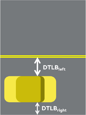
Not all trips had complete speedometer or lane tracking data. Speedometer and lane tracking data samples were noisy, and speedometer data samples in some vehicles were discretized into 1 km/h steps. Speedometer, left lane marker position, and right lane marker position measurements were each smoothed using independent Kalman filters. The lane marker position Kalman filter used measurement error values presented in a report from Perez et al. (2014), which characterized the performance of the lane tracking system in comparison to manually verified lane positions.
Trip segments with a DTLB below zero were considered a detected lane departure. In addition, departures were only considered for this report when the type of lane marker detected by SHRP 2 was “road gutter” or “road edge,” limiting our analysis to road departures and excluding lane departures and lane changes. Departures in each trip with a duration less than 200 ms or that had invalid lane tracking data were excluded. The SHRP 2 lane tracking data include a confidence measure that ranges from 0 to 1,024 for the left side and right side lane markers. The value 0 indicates that there is no confidence in the measured position. The value 1,024 indicates that there is high confidence in the measured position. Perez et al. (2014) recommended that lane tracking values with confidence below 512 should be considered invalid. A departure was considered to have ended under one of two conditions: 1) the DTLB value was greater than zero, or 2) the confidence value was less than 512.
NCHRP 17-43 Road Departure Database
The NCHRP 17-43 database completed data collection in 2021 and contains roadside crash information to run-off-road crashes sampled in NASS/CDS. The NCHRP 17-43 cases were selected from case years 2011 to 2015 in the NASS/CDS. NASS/CDS is a nationally representative in-depth crash database that contains detailed information about the crash, the vehicle, and the occupants (NCSA, 2016). This includes a scaled scene diagram and photographs of the crash scene and occupant injury information. Because NASS/CDS is a stratified sample, each case in NASS/CDS is assigned a case weight to correct for the sampling bias. Despite the comprehensive description of each case contained in NASS/CDS, most roadside and trajectory information is not
coded in the dataset. The NCHRP 17-43 database codes additional information based on the scene diagram and photographs available for each NASS/CDS case. The data collection methods are described in a later section.
The NCHRP 17-43 database focuses on single-vehicle run-off-road crashes to support improvement of roadside crash safety. NASS/CDS cases were considered for inclusion in the NCHRP 17-43 database if only one vehicle was involved and the crash type was “drive off road.” Cases were excluded from the sample if the departure occurred after the driver successfully avoided another crash, if the driver lost control of the vehicle, if there was an impact before the departure, or if the driver was in an intersection. The remaining cases are single-vehicle, drift out of lane, run-off-road crashes. Each crash was manually inspected before extracting the relevant data. Most of the excluded cases at this stage either did not have a scaled scene diagram or were missing necessary trajectory points. The resulting dataset contains a total of 1,581 cases representing 510,154 drift out of lane, single-vehicle roadway departure crashes in the U.S., which were added to the NCHRP 17-43 database (Table 3).
Table 3. Case Selection Criteria for the NCHRP 17-43 Database
| Exclusion Criteria | Cases | Weighted Cases |
|---|---|---|
| NASS/CDS 2011-2015 | 16,773 | 10,099,582 |
| Single Vehicle (VEHFORMS = 1) | 5,462 | 2,929,462 |
| Run Off Road Crash (ACCTYPE = 1,6) | 2,446 | 1,207,540 |
| Not Due to Avoidance (PREMOVE ≠ 17) | 2,422 | 1,192,065 |
| Critical Crash Event is leaving lane/road (PREEVENT = 10-13) | 2,278 | 1,097,865 |
| Manual Inspection (Scaled Scene Diagrams, Not Intersection Related) | 1,581 | 510,154 |
State Crash and Maintenance Data
Police-reported crash data, roadside inventory files, and roadside hardware maintenance files for three states, Iowa, Washington, and Tennessee, were collected and examined to identify potential unreported and police-reported encroachments to be included in the 17-88 ED. Representative roadways from each participating state were selected using the following general procedure:
- Categorize state-maintained roadways in each state based on the Highway Safety Manual (HSM) framework/roadway subtypes shown in Table 4.
- For each road subtype, evaluate the ranges of roadway characteristics for the longest routes for that specific roadway subtype. Primary roadway characteristics examined include traffic volume, posted speed limit, shoulder width, median type/width (if applicable), lane width, and rumble strip presence.
- Select representative routes for each roadway type category considering the ranges of roadway characteristics determined in Step 2.
Table 4. Roadway Types Considered in the HSM Predictive Methodolog
| Land Use | Roadway Segment Configuration | |
|---|---|---|
| Undivided | Divided | |
| Rural | 2-lane, two-way (RU2L2W) Multilane highway (RUMLH) Ramp segments | Multilane highway (R4D) 4-lane freeway (R4F) 6-lane freeway (R6F) 8-lane freeway (R8F) |
| Urban (suburban) | Arterial (2U/3T and 4U/5T) Ramp segments | Arterial (U4D) 4-lane freeway (U4F) 6-lane freeway (U6F) 8-lane freeway (U8F) 10-lane freeway (U10F) |
For the selected routes from each state, police-reported encroachment crashes were determined for a time span corresponding with available maintenance data. Maintenance data were limited to roadside hardware devices that typically require repair following a vehicle impact, such as a metal beam and cable barrier with associated end terminals, impact attenuators, and signs. Concrete barriers were not included, as maintenance on these devices does not occur for minor/unreported impacts. Unreported hits to natural objects (e.g., trees, boulders) were not included, as impacts to these objects would not trigger a maintenance record. Available maintenance records were matched to the police-reported crashes for the same time frame to identify unreported crashes with each device type. Both police-reported and unreported crashes were included in the 17-88 ED.
The sections below provide additional details on the representative routes selected from each state as well the selection criteria for included police-reported encroachment crashes.
Iowa State Representative Routes and Data
A total of 11 routes were selected from Iowa for inclusion, as summarized in Table 5. This includes the total length of each route as well as a single year representation of traffic flow in units of million vehicle miles traveled (MVMT). For each route, Table 5 shows the proportion of the total roadway length in each general HSM roadway type category.
Table 5. Summary Characteristics of Selected Iowa State Routes
| Route Designation | Total Length (mi) | Single Year MVMT | Roadway Type (% of total length) | |||
|---|---|---|---|---|---|---|
| Rural Undivided | Urban Undivided | Rural Divided | Urban Divided | |||
| I-29 | 130.4 | 832.25 | 0 | 0 | 91 | 9 |
| I-35 | 179.2 | 1521.42 | 0 | 0 | 92 | 8 |
| I-80 | 261.6 | 3171.31 | 0 | 0 | 81 | 19 |
| I-235 | 4.2 | 171.50 | 0 | 0 | 0 | 100 |
| I-380 | 58.8 | 723.97 | 0 | 0 | 64 | 36 |
| SR 4 | 141 | 100.09 | 97 | 3 | 0 | 0 |
| SR 6 | 207.9 | 460.14 | 73 | 15 | 3 | 9 |
| SR 18 | 300 | 511.69 | 79 | 7 | 13 | 1 |
| SR 28 | 15.9 | 61.74 | 45 | 23 | 0 | 32 |
| SR 30 | 304.6 | 570.59 | 60 | 5 | 25 | 10 |
| SR 218 | 195.3 | 600.40 | 42 | 5 | 46 | 7 |
Table 6 provides a comparison of the crash characteristics for the NCHRP 17-88 selected Iowa routes to all similarly classified routes in the entire state. For the selected Iowa routes of a given route type/subtype, the average crash rate was determined by summing the crash rate multiplied by the corresponding MVMT for each selected route and then dividing by the total MVMT for the same routes. A similar procedure was followed to determine the weighted ratio of fixed object crashes to total crashes. For each route type, the rightmost columns in Table 6 show the crash rate and fixed object to total crash ratio for all of the similarly classified Iowa routes available.
Note that by design, our approach for selecting roadways prioritized a wide range of roadway and traffic characteristics over selecting a sample of roadways that was simply representative of the roadways statewide. The rationale for this was to be sure that we were capturing encroachment crashes across the widest variety of roadway and traffic conditions, as previous encroachment data were somewhat limited in this regard, especially relative to traffic volumes. Based on the available data, however, the selected Iowa routes have relatively similar crash characteristics to the correspondingly classified routes across the entire state. This is especially true for the rural undivided roadways. In general, the selected urban undivided, rural divided, and urban divided roadways have higher overall crash rates compared to all similarly classified roadways across the state.
Table 6. Comparison of Crash Characteristics for Selected IA Routes and All Similarly Classified Routes in the State
| Route Type | Subtype | Sample Length [mi] | Total MVMT (1 year) | All Crashes (3 yrs) | Fixed Object Crashes (3 yrs) | Selected | Routes | Entire S | tate |
|---|---|---|---|---|---|---|---|---|---|
| VMT-Weighted Fixed Object to All Crash Ratio | VMT-Weighted Crash Rate | Fixed Object to All Crash Ratio | Crash Rate | ||||||
| Rural Undivided | RU2L2W | 776.5 | 955.98 | 2408 | 303 | 0.12 | 0.84 | 0.14 | 0.83 |
| RUMLH | 20.8 | 8.95 | 13 | 2 | 0.15 | 0.48 | |||
| All | 797.3 | 964.93 | 2421 | 305 | 0.12 | 0.84 | |||
| Urban Undivided | 2U/3T | 47 | 110.45 | 723 | 54 | 0.07 | 2.18 | 0.06 | 2.87 |
| 4U/5T | 34.3 | 165.9 | 1921 | 91 | 0.05 | 3.86 | |||
| 6U | 0.4 | 2.87 | 31 | 0 | 0.00 | 3.60 | |||
| All | 81.7 | 279.22 | 2675 | 145 | 0.06 | 3.19 | |||
| Rural Divided | R4D | 170.8 | 654.22 | 2063 | 250 | 0.12 | 1.05 | 0.20 | 0.49 |
| R4F | 535.5 | 4384.14 | 11478 | 2981 | 0.27 | 0.87 | |||
| R6F | 39.5 | 313.14 | 1100 | 290 | 0.27 | 1.17 | |||
| All | 745.8 | 5351.5 | 14641 | 3521 | 0.25 | 0.91 | |||
| Urban Divided | U4D | 46.5 | 285.41 | 2718 | 144 | 0.07 | 3.17 | 0.12 | 0.86 |
| U4F | 73.4 | 888.18 | 2700 | 639 | 0.25 | 1.01 | |||
| U6F | 38.4 | 760.15 | 1898 | 467 | 0.26 | 0.83 | |||
| U8F | 12.9 | 363.85 | 1289 | 259 | 0.21 | 1.18 | |||
| U10F | 2.9 | 89.25 | 360 | 55 | 0.21 | 1.34 | |||
| All | 174.1 | 2386.84 | 8965 | 1564 | 0.22 | 1.25 |
The Iowa Department of Transportation (Iowa DOT) conducts maintenance repairs on much of its roadside hardware devices, including guardrail, cable barrier, and impact attenuators. The current maintenance system used by Iowa DOT captures daily activity logs for maintenance employees, recorded by function, route, and milepost. The data available are sufficiently detailed to identify maintenance on a specific roadside hardware device, such as guardrail, but there is no data element that distinguishes between crash damage repair and other maintenance activities. There are data on labor, equipment, and materials used for each maintenance record, so this potentially could be used to identify crash damage repairs. The research team has obtained Iowa DOT maintenance data for work completed between 2012 through 2017 for the selected Iowa routes. Police-reported
crash data for the previous 10 years along with roadway and traffic data for Iowa are available through the Iowa DOT open GIS portal. The Iowa crash data include all crashes across Iowa and are not limited to crashes occurring on state-maintained Iowa roadways. The research team has obtained 6 years of crash data, from 2012 through 2017, to match the obtained maintenance information.
Available crash data were used to select the police-reported crashes on the representative Iowa routes to be included in the NCHRP 17-88 encroachment database. For the 2012 through 2017 period, there were a total of 315,646 crashes involving 544,213 vehicles across the entire state on all roadways. On the 11 selected Iowa representative routes, there were a total of 54,163 crashes involving 91,778 vehicles. These 11 Iowa routes represent approximately 17% of the total crashes occurring statewide in Iowa. Considering only state-maintained roadways, there were 129,342 crashes involving 218,812 vehicles occurring from 2012 through 2017. The 11 Iowa routes selected represent approximately 42% of the crashes occurring on state-maintained routes in Iowa.
Prior to the identification of run-off-road crashes, the crashes were categorized as single-vehicle or multiple-vehicle crashes using the number of vehicles variable (vehicles) in the crash table. A single-vehicle crash was defined as vehicles = 1, while a multiple-vehicle crash was defined as vehicles > 1. Selection of run-off-road crashes were then completed for each group separately.
The Iowa crash data for each year on the selected routes were combined and then merged with the available vehicle data for each crash. A total of 22,757 vehicles were involved in single-vehicle crashes on the selected Iowa routes from 2012 through 2017. Unlike the Washington and Tennessee data, the Iowa data have a specific sequence of events (SOE) code pertaining to the presence of a phantom vehicle (i.e., a non-contact vehicle). A total of 215 of the single-vehicle crashes had a phantom vehicle coded in one of the SOE, which represents approximately 1% of the available single-vehicle crashes. Since the Iowa data do not code phantom vehicles separately in the vehicle file (as do Washington and Tennessee), there were no phantom vehicle records to exclude from the available single-vehicle crashes. Information on the presence of a phantom vehicle will be used, however, to determine if another vehicle influenced the “single vehicle” crash to populate the “AnotherVehicle” variable present in the NCHRP 17-88 database.
Each of the 22,757 vehicles involved in a single-vehicle crash were examined further to determine if inclusion in the NCHRP 17-88 encroachment database was warranted. The Iowa crash data do not have a single specific variable indicating whether a vehicle departed the roadway and also do not contain a data element indicating the crash location in relation to the roadway. As a result, only the SOE (seqevents1 - 4) variables were used in the selection process. The following inclusion criteria were used to select appropriate cases:
- Run-off-road code present anywhere in the four possible SOE variables.
- OR fixed object code present anywhere in the four SOE variables.
Examination of the available data revealed that “run-off-road” is not always included in the SOE; for example, a vehicle that leaves the roadway and impacts a guardrail could be coded with one SOE as “collision with guardrail” or with two SOE variables as “ran off the road” followed by “collision with guardrail.” Given this, either a “run-off-road” code present in the SOE variables or
a fixed object code present was permissible. Application of the three selection criteria resulted in 12,509 single-vehicle crashes identified as candidates to include in the NCHRP 17-88 database.
The fixed object-only crashes (meeting only criterion 2 above) were examined further to ensure these were crashes that should be included in the NCRHP 17-88 database. This was to ensure that fixed object impacts occurring while the vehicle remains on the roadway were not included, such as overheight trucks impacting a bridge/overpass underside. No fixed object cases were excluded. The 12,509 crashes represent approximately 55% of the available single-vehicle crashes. Of the 10,248 omitted single-vehicle crashes, animal strikes (7,637 cases) accounted for approximately 75% of the omitted cases. Vehicle rollover on the roadway (370 cases), other non-collision events (367), and non-motorist strikes (347) account for the majority of the remaining excluded cases. These four crash types account for approximately 85% of the single-vehicle cases excluded. Note that approximately 8% (822 cases) of the 10,248 omitted single-vehicle crashes had “not reported” or unknown SOE information.
For multiple-vehicle crashes (vehicles > 1), the case selection process was similar to the single-vehicle crashes and focused only on the vehicle-level SOE variables so that only crash-involved vehicles that departed the traveled way were included. As an example, consider a crash where vehicle 1 strikes vehicle 2. Vehicle 2 then remains on the roadway while vehicle 1 departs the roadway and impacts a guardrail. In this case, only vehicle 1 would be appropriate to include in the NCHRP 17-88 database.
The initial inclusion criterion for vehicles involved in a multiple-vehicle crash was that the vehicle had a run-off-road or fixed object coded in any of the four possible SOE variables. Using this criterion, there were 2,214 vehicles involved in a multiple-vehicle crash, which represents approximately 3% of the 69,021 vehicles involved in multiple-vehicle crashes on the selected Iowa routes from 2012 through 2017. All vehicles with run-off-road coded in one or more SOE variables were included by default. Vehicles with one or more fixed objects struck but no run-off-road coded in the SOE variables were examined further to exclude any impacts only with objects present only on the roadway; no cases were excluded. The result was 2,214 vehicles selected.
The multiple-vehicle crashes were examined in more detail to identify crossover crashes. As the Iowa SOE data have specific categories for crossing centerline and crossing median, these were used directly to identify crossover crashes.
Washington State Representative Routes and Data
A total of 12 routes were selected from Washington State for inclusion, as summarized in Table 7. This includes the total length of each route as well as a single year representation of traffic flow in units of MVMT. For each route, Table 7 shows the proportion of the total roadway length in each general HSM roadway type category.
Table 7. Summary Characteristics of Selected Washington State Routes
| Route Designation | Total Length (mi) | Single Year MVMT | Roadway Type (% of total length) | |||
|---|---|---|---|---|---|---|
| Rural Undivided | Urban Undivided | Rural Divided | Urban Divided | |||
| I-5 | 255.5 | 8718.88 | 0 | 0 | 38 | 62 |
| I-90 | 271.0 | 3005.72 | 0 | 0 | 80 | 20 |
| I-182 | 13.9 | 206.14 | 0 | 0 | 0 | 100 |
| I-405 | 12.3 | 737.08 | 0 | 0 | 0 | 100 |
| SR 2 | 310.6 | 884.24 | 75 | 10 | 11 | 4 |
| SR 8 | 20.6 | 127.43 | 0 | 0 | 95 | 5 |
| SR 12 | 323.8 | 718.75 | 79 | 4 | 4 | 13 |
| SR 99 | 29.0 | 347.87 | 0 | 33 | 0 | 67 |
| SR 101 | 359.3 | 794.32 | 86 | 6 | 4 | 4 |
| SR 167 | 23.9 | 723.78 | 0 | 23 | 0 | 77 |
| SR 202 | 26.0 | 115.90 | 22 | 78 | 0 | 0 |
| SR 522 | 20.2 | 279.35 | 0 | 39 | 0 | 61 |
Table 8 provides a comparison of the crash characteristics for the NCHRP 17-88 selected Washington routes to all similarly classified routes in the entire state. For the selected Washington routes of a given route type/subtype, the average crash rate was determined by summing the crash rate multiplied by the corresponding MVMT for each selected route and then dividing by the total MVMT for the same routes. A similar procedure was followed to determine the weighted ratio of fixed object crashes to total crashes. For each route type, the rightmost columns in Table 8 show the crash rate and fixed object to total crash ratio for all of the similarly classified Washington routes available.
Table 8. Comparison of Crash Characteristics for Selected WA Routes and All Similarly Classified Routes in the State
| Route Type | Subtype | Sample Length [mi] | Total MVMT (1 year) | All Crashes (3 yrs) | Fixed Object Crashes (3 yrs) | Selected Routes | Entire State | ||
|---|---|---|---|---|---|---|---|---|---|
| VMT-Weighted Fixed Object to All Crash Ratio | VMT-Weighted Crash Rate | Fixed Object to All Crash Ratio | Crash Rate | ||||||
| Rural Undivided | RU2L2W | 804.7 | 1177.89 | 2910 | 754 | 0.26 | 0.82 | 0.25 | 1.04 |
| RUMLH | Not Applicable (no suitable RUMLH routes available) | ||||||||
| All | 804.7 | 1177.89 | 2910 | 754 | 0.26 | 0.82 | |||
| Urban Undivided | 2U/3T | 68.5 | 299.51 | 1700 | 143 | 0.09 | 1.89 | 0.07 | 3.10 |
| 4U/5T | 40.5 | 423.85 | 3753 | 213 | 0.06 | 2.95 | |||
| 6U | 14.7 | 197.78 | 3041 | 117 | 0.04 | 5.13 | |||
| All | 123.7 | 921.14 | 8494 | 473 | 0.07 | 3.07 | |||
| Rural Divided | R4D | 73.8 | 396.69 | 824 | 264 | 0.33 | 0.69 | 0.33 | 0.48 |
| R4F | 252.2 | 2053.92 | 3156 | 1020 | 0.33 | 0.51 | |||
| R6F | 72 | 1615.98 | 1667 | 619 | 0.37 | 0.34 | |||
| All | 398 | 4066.59 | 5647 | 1903 | 0.35 | 0.46 | |||
| Urban Divided | U4D | 61.5 | 519.98 | 3449 | 430 | 0.18 | 2.21 | 0.14 | 1.01 |
| U4F | 121 | 2165.57 | 4579 | 1060 | 0.25 | 0.70 | |||
| U6F | 126.6 | 5052.58 | 12324 | 1644 | 0.14 | 0.81 | |||
| U8F | 45.3 | 2953.49 | 9593 | 1014 | 0.10 | 1.08 | |||
| U10F | Not Applicable (no suitable U10F routes available) | ||||||||
| All | 354.4 | 10691.62 | 29945 | 4148 | 0.15 | 0.93 | |||
Based on the available data, the selected Washington routes have similar crash characteristics to the correspondingly classified routes across the entire state. This is especially true for the rural divided roadways, urban undivided roadways, and for the ratios of fixed object to total crashes. In
general, the selected rural undivided and urban divided roadways have lower overall crash rates compared to all similarly classified roadways across the state.
The Washington State DOT maintains an electronic database of approximately 10 years of maintenance records for various roadside features that the agency is responsible for maintaining. The research team has obtained Washington State DOT maintenance records from years 2010 through 2020. Police-reported crash data matched with detailed roadway and traffic data for Washington State is available through the Highway Safety Information System (HSIS). Washington State HSIS data have been obtained from 2005 through 2018. Note that 2018 is currently the most recent HSIS year available. Police-reported crash and corresponding maintenance data are thus available for a 9-year period, 2010 through 2018. An examination of all the provided Washington State DOT maintenance data, however, revealed very few maintenance entries for years 2010 and 2011, with less than 20 total maintenance entries for all maintained devices for both years combined. For more recent years of maintenance data, there were between 500 and 2,000 entries for all maintained devices. As there were so few entries for 2010 and 2011, maintenance data from these years were excluded from further analysis. As a result, a 7-year period was selected for analysis, years 2012 through 2018.
Available HSIS crash data were used to select the police-reported crashes on the representative routes to be included in the NCHRP 17-88 encroachment database. For the 2012 through 2018 period, there were a total of 354,684 crashes involving 703,450 vehicles across the entire state on state-maintained roadways. On the 12 selected representative routes, there were a total of 192,187 crashes involving 388,779 vehicles. These 12 Washington State routes represent approximately half of the total crashes occurring statewide on roadways maintained by Washington State.
Prior to the identification of encroachment crashes, the crashes were categorized as single-vehicle or multiple-vehicle crash using the number of vehicles variable (numvehs) in the crash table. A single-vehicle crash was defined as numvehs = 1 while a multiple-vehicle crash was defined as numvehs > 1. Selection of run-off-road crashes were then completed for each group separately.
The HSIS crash data for each year on the selected routes were combined and then merged with the available vehicle data for each crash. A total of 65,903 vehicles were involved in single-vehicle crashes on the selected Washington routes from 2012 through 2018. Many of these single-vehicle crashes, however, involved a phantom vehicle, that is, a vehicle identified in the available vehicle data but not actually struck. In these cases, the crash-level data indicate a single-vehicle crash (i.e., numvehs = 1) but merging in the associated vehicle-level data for the crash results in more than one vehicle listed. While identified, these phantom vehicles do not have any SOE or other information present. Excluding these vehicles resulted in 44,801 crash-involved vehicles. Information on the presence of a phantom vehicle was used, however, to determine if another vehicle influenced the “single vehicle” crash to populate the “AnotherVehicle” variable present in the NCHRP 17-88 database.
Each of the 44,801 vehicles involved in a single-vehicle crash were examined further to determine if inclusion in the NCHRP 17-88 encroachment database was warranted. As the Washington HSIS data do not have a specific variable indicating whether a vehicle left the roadway, a combination of four variables was used in the selection process: Accident type (Acctype), impact location
(Impact), object struck (Object1, Object2), and SOE (Event1, Event2, Event3, Event4). The following inclusion criteria were used to select appropriate cases:
- Acctype = 33, 60, 61, 62 (strikes appurtenance, ran into ditch, ran into water, ran over embankment).
- OR Acctype = 50 (rollover) and location NOT on road.
- OR Acctype = 34 (other object) and location NOT on road.
- OR run-off-road code present anywhere in SOE. Note that the Washington HSIS data contains up to four “events” for each vehicle.
The “Acctype,” “Impact,” and “Object1/2” variables are coded for the entire crash. These three variables can be used to reliably identify cases of interest in this instance since these crashes involve only a single vehicle (i.e., the entire crash applies directly to the only involved vehicle). The “Impact” variable identifies the location of the crash relative to the roadway (e.g., specific lane, shoulder, median, or beyond shoulder). Only the shoulder/median/beyond shoulder locations were considered for inclusion based solely on this variable. Application of the four selection criteria resulted in 34,272 single-vehicle crashes identified as candidates to include in the 17-88 ED.
Examination of the available data revealed that “run-off-road” is not always included in the SOE; for example, a vehicle that leaves the roadway and impacts a guardrail could be coded with one SOE as “collision with fixed object” or with two SOE variables as “ran off the road” followed by “collision with fixed object.” There were 560 additional single-vehicle crashes with an object struck in the SOE but not captured by the four selection criteria listed above. All but 14 of these were included in the dataset, bringing the single vehicle impact total to 34,818 cases. The 14 excluded impacts were primarily overheight trucks impacting a bridge/overpass underside (11 cases). Another crash involved an impact with a reversible lane gate, and two others involved an impact with only debris in the road. The 34,818 crashes represent approximately 78% of the available single-vehicle crashes. Of the 9,983 omitted single-vehicle crashes, animal strikes (4,426 cases) and pedestrians struck (1,328 cases) together accounted for more than half of these. Non-collision fire (1,051 cases), vehicle rollover on the roadway (1,046 cases), other object strike (936 cases), and bicyclist strike (526 cases) account for the majority of the remaining excluded cases. These six crash types account for approximately 93% of the single-vehicle cases excluded.
For multiple-vehicle crashes (numvehs > 1), the case selection process was similar to the single-vehicle crashes but focused on the vehicle-level SOE variables so that only crash-involved vehicles that departed the traveled way were included. The initial inclusion criterion for vehicles involved in a multiple-vehicle crash was that the vehicle had a run-off-road or fixed object coded in any of the four possible SOE variables. Using this criterion, there were 10,478 vehicles involved in a multiple-vehicle crash, which represents approximately 3% of the 322,860 vehicles involved in multiple-vehicle crashes on the selected Washington routes from 2012 through 2018. All vehicles with run-off-road coded in one or more SOE variables were included by default. Vehicles with one or more fixed objects struck but no run-off-road coded in the SOE variables were examined further to exclude any impacts only with objects present only on the roadway. A total of 49 vehicles were excluded based on object struck: 29 vehicles struck the underside of a bridge, 12 struck only miscellaneous debris in road, five struck lane control gates, two struck fallen rock/trees in the roadway, and one struck construction material. A significant number of the fixed object-only
vehicles (1,283 total) had no object1 or object2 listed; these cases were also excluded since we cannot be sure the vehicle did in fact leave the roadway and impact a fixed object. The result was 9,146 vehicles selected.
The multiple-vehicle crashes were examined in more detail to identify cross median crashes. The HSIS data do not have a specific variable identifying cross median crashes. Vehicles that departed the roadway and collided with a vehicle in the opposing direction were identified using a combination of the crash-level vehicle direction variables (v1dircde and v2dircde should be in opposing directions) as well as a run-off-road coded in at least one of the four vehicle event sequence variables (event1, event2, event3 or event4). Only the vehicle that departed the roadway was included in the 17-88 ED.
Tennessee State Representative Routes and Data
A total of 11 routes were selected from Tennessee for inclusion, as summarized in Table 9. This includes the total length of each route as well as a single year representation of traffic flow in units of MVMT. For each route, Table 9 shows the percentage of the total roadway length in each general HSM roadway type category.
Table 9. Summary Characteristics of Selected Tennessee State Routes
| Route Designation | Total Length (mi) | Single Year MVMT | Roadway Type (% of total length) | |||
|---|---|---|---|---|---|---|
| Rural Undivided | Urban Undivided | Rural Divided | Urban Divided | |||
| I-24 | 152.0 | 3690.24 | 0 | 0 | 52 | 48 |
| I-40 | 407.0 | 7757.26 | 0 | 0 | 60 | 40 |
| I-65 | 103.2 | 2449.13 | 0 | 0 | 54 | 46 |
| I-240 | 15.7 | 742.12 | 0 | 0 | 0 | 100 |
| SR 1 | 523.9 | 2085.82 | 41 | 29 | 14 | 16 |
| SR 15 | 256.0 | 756.02 | 18 | 12 | 59 | 11 |
| SR 155 | 25.5 | 540.06 | 0 | 18 | 0 | 82 |
| SR 33 | 161.6 | 598.54 | 65 | 20 | 11 | 4 |
| SR 34 | 153.2 | 825.05 | 27 | 17 | 21 | 35 |
| SR 69 | 145.4 | 182.26 | 86 | 13 | 0 | 1 |
| SR 386 | 12.5 | 271.20 | 0 | 0 | 0 | 100 |
Table 10 provides a comparison of the crash characteristics for the NCHRP 17-88 selected Tennessee routes to all similarly classified routes in the entire state. For the selected Tennessee routes of a given route type/subtype, the average crash rate was determined by summing the crash rate multiplied by the corresponding MVMT for each selected route and then dividing by the total MVMT for the same routes. A similar procedure was followed to determine the weighted ratio of fixed object crashes to total crashes. For each route type, the rightmost columns in Table 10 show the crash rate and fixed object to total crash ratio for all of the similarly classified Tennessee routes available.
Table 10. Comparison of Crash Characteristics for Selected TN Routes and All Similarly Classified Routes in the State
| Route Type | Subtype | Sample Length [mi] | Total MVMT (1 year) | All Crashes (3 yrs) | Fixed Object Crashes (3 yrs) | Selected Routes | Entire State | ||
|---|---|---|---|---|---|---|---|---|---|
| VMT-Weighted Fixed Object to All Crash Ratio | VMT-Weighted Crash Rate | Fixed Object to All Crash Ratio | Crash Rate | ||||||
| Rural Undivided | RU2L2W | 473 | 780.81 | 917 | 174 | 0.23 | 1.62 | 0.29 | 1.76 |
| RUMLH | 57.4 | 238.68 | 136 | 11 | 0.10 | 1.32 | |||
| All | 530.4 | 1019.49 | 1053 | 185 | 0.20 | 1.55 | |||
| Urban Undivided | 2U/3T | 113.4 | 297.87 | 347 | 38 | 0.12 | 3.00 | 0.07 | 4.34 |
| 4U/5T | 132.5 | 1027.84 | 1958 | 115 | 0.05 | 4.95 | |||
| 6U | 18.4 | 200.17 | 687 | 23 | 0.03 | 8.77 | |||
| All | 264.3 | 1525.88 | 2992 | 176 | 0.06 | 5.07 | |||
| Rural Divided | R4D | 276.8 | 815.37 | 564 | 108 | 0.19 | 0.74 | 0.32 | 0.57 |
| R4F | 359.3 | 4827.72 | 1691 | 538 | 0.36 | 0.52 | |||
| R6F | 20.9 | 462.72 | 110 | 30 | 0.32 | 0.46 | |||
| All | 657 | 6105.81 | 2365 | 676 | 0.34 | 0.54 | |||
| Urban Divided | U4D | 174.3 | 1157.65 | 1037 | 76 | 0.07 | 2.63 | 0.15 | 1.50 |
| U4F | 169.4 | 3139.88 | 1443 | 338 | 0.30 | 0.77 | |||
| U6F | 62.9 | 2170.2 | 1355 | 219 | 0.20 | 1.11 | |||
| U8F | 71 | 3321.08 | 757 | 182 | 0.17 | 1.00 | |||
| U10F | 26.7 | 1457.71 | 346 | 48 | 0.17 | 1.09 | |||
| All | 504.3 | 11246.52 | 4938 | 863 | 0.20 | 1.14 | |||
Based on the available data, the selected Tennessee routes have crash characteristics similar to the correspondingly classified routes across the entire state. This is especially true for the rural divided roadways. In general, the selected rural undivided and urban divided roadways have lower overall crash rates compared to all similarly classified roadways across the state. Also, the selected urban undivided roadways have higher overall crash rates compared to all similarly classified roadways across the state.
Unlike Washington State, the Tennessee Department of Transportation (Tennessee DOT) employs private contractors to conduct maintenance repairs on much of its roadside hardware devices, including guardrail, cable barrier, and impact attenuators. The research team has obtained contractor reports of devices that were repaired between 2016 through 2019 for the selected Tennessee routes. Tennessee DOT also maintains an in-house electronic database of approximately 5 years of maintenance records for roadway signs. The research team has obtained Tennessee DOT sign maintenance records from years 2015 through 2019. Police-reported crash data matched with detailed roadway and traffic data for Tennessee are available through the Electronic Tennessee Road Information System (ETRIMS). Note that Tennessee ETRIMS data include all crashes across Tennessee and are not limited to crashes occurring on state-maintained Tennessee roadways. The research team has obtained ETRIMS data from 2013 through 2020. A 5-year period was selected for use, years 2015 through 2019, as this represents the overlap between the available maintenance and crash data.
Available ETRIMS crash data were used to select the police-reported crashes on the representative routes to be included in the 17-88 ED. For the 2015 through 2019 period, there were a total of 1,040,041 crashes involving 1,923,294 vehicles across the entire state on all roadways. On the 11 selected Tennessee representative routes, there were a total of 175,180 crashes involving 337,430 vehicles. These 11 Tennessee routes represent approximately 17% of the total crashes occurring statewide in Tennessee. Considering only state-maintained roadways, there were 577,405 crashes involving 1,096,663 vehicles occurring from 2015 through 2019. The 11 Tennessee routes selected
represent approximately 30% of the crashes occurring on state-maintained routes in Tennessee. Although this proportion was lower than the routes selected for Washington State (the selected Washington routes represented approximately half of the crashes across all state routes), Tennessee has approximately twice the number of unique state routes and twice the total state-maintained road mileage of Washington State.
Prior to the identification of run-off-road crashes, the crashes were categorized as single-vehicle or multiple-vehicle crashes using the number of vehicles variable (totalvehicles) in the crash table. A single-vehicle crash was defined as totalvehicles = 1 while a multiple-vehicle crash was defined as totalvehicles > 1. Selection of run-off-road crashes were then completed for each group separately.
The Tennessee crash data for each year on the selected routes were combined and then merged with the available vehicle data for each crash. A total of 36,862 vehicles were involved in single-vehicle crashes on the selected Tennessee routes from 2015 through 2019. Similar to the Washington State data, there were single-vehicle crashes present that involved a phantom vehicle (i.e., a vehicle identified in the available vehicle data but not actually struck). Although phantom vehicles were present in the Tennessee data, they were less frequent compared to the Washington data; approximately 2% of Tennessee vehicles were involved in single-vehicle crashes compared to nearly one third of vehicles in Washington crashes. The reason for this discrepancy is not known but could be linked to police reporting differences between the two states. In the phantom vehicle cases, the crash-level data indicate a single-vehicle crash (i.e., totalvehicles = 1), but merging in the associated vehicle-level data for the crash results in more than one vehicle listed. While identified, these phantom vehicles do not have any SOE or other information present. Excluding these vehicles resulted in 36,091 crash-involved vehicles. Information on the presence of a phantom vehicle was used, however, to determine if another vehicle influenced the “single vehicle” crash to populate the “AnotherVehicle” variable present in the NCHRP 17-88 database.
Each of the 36,091 vehicles involved in a single-vehicle crash were examined further to determine if inclusion in the NCHRP 17-88 encroachment database was warranted. Similar to Washington, the Tennessee crash data do not have a single specific variable indicating whether a vehicle departed the roadway. As a result, two variables were used in the selection process: roadway relation (relationtoroadwayfirst) and SOE (event_seq1-10). The following inclusion criteria were used to select appropriate cases:
- Relationtoroadwayfirst = 2, 3, 4, 5, 6, 7, 8, 10 (shoulder, median barrier, roadside left, roadside right, off roadway/unknown, parking lane, gore, outside trafficway).
- OR run-off-road code present anywhere in the 10 possible SOE variables.
- OR fixed object code present anywhere in the ten SOE variables.
The “Relationtoroadwayfirst” variable is coded for the entire crash and indicates the location of the crash relative to the primary roadway. This variable can be used to reliably identify cases of interest in this instance since these crashes involve only a single vehicle, that is, the entire crash applies directly to the only involved vehicle. Similar to Washington State, “run-off-road” is not always included in the SOE; for instance, a vehicle that leaves the roadway and impacts a guardrail could be coded with one SOE as “collision with guardrail” or with two SOE variables as “ran off the road” followed by “collision with guardrail.” Given this, either a “run-off-road” code present
in the SOE variables or a fixed object code present was permissible. Note that an accident type variable was also used in the Washington data to help identify crashes where a vehicle departed the roadway. Although Tennessee crash data do contain crash type variable at the crash level, the Tennessee variable is much less detailed than the corresponding Washington variable. The Tennessee crash type variable categorizes all single-vehicle crashes into a single category (i.e., no collision with vehicle). As the variable offered little additional information that could be used to aid in identifying suitable cases, it was not used in the selection process. Application of the three selection criteria resulted in 26,036 single-vehicle crashes identified as candidates to include in the 17-88 ED.
The fixed object-only crashes (i.e., meeting only criterion 3 above) were examined further to ensure these were crashes that should be included in the 17-88 ED. All but 10 of these were included in the dataset, bringing the single vehicle impact total to 26,026 cases. The 10 excluded impacts were overheight trucks impacting a bridge/overpass underside.
The 26,026 crashes represent approximately 72% of the available single-vehicle crashes. Of the 10,065 omitted single-vehicle crashes, animal strikes (5,171 cases) and other non-fixed object struck (1,794 cases) together accounted for approximately 70% of the omitted cases. Pedestrian strike (528), vehicle rollover on the roadway (406 cases), thrown/falling object (396 cases), and bicyclist strike (111 cases) account for the majority of the remaining excluded cases. These six crash types account for approximately 84% of the single-vehicle cases excluded. Note that approximately 8.6% (864 cases) of the 10,065 omitted single-vehicle crashes had missing or unknown SOE information.
For multiple-vehicle crashes (totalvehicles > 1), the case selection process was similar to the single-vehicle crashes but focused on the vehicle-level SOE variables so that only crash-involved vehicles that departed the traveled way were included.
The initial inclusion criterion for vehicles involved in a multiple-vehicle crash was that the vehicle had a run-off-road (including cross median or cross centerline) or fixed object coded in any of the 10 possible SOE variables. Using this criterion, there were 18,305 vehicles involved in a multiple-vehicle crash, which represents approximately 6% of the 300,568 vehicles involved in multiple-vehicle crashes on the selected Tennessee routes from 2015 through 2019.
For Washington, all vehicles with run-off-road coded in one or more SOE variables were included by default. Vehicles with one or more fixed objects struck but no run-off-road coded in the SOE variables were examined further to exclude any impacts only with objects present only on the roadway. In the process of applying the same process to the Tennessee data, the research team discovered that the Tennessee SOE is identical for each vehicle in multiple-vehicle crashes, that is, it represents a crash-level variable rather than the vehicle-level data indicated in the available Tennessee crash data documentation.
Motorcycle Crash Causation Data
Only on-scene crash cases from MCCS were considered for inclusion in the 17-88 ED. The control case data include only information on riders passing the crash location and not involved in an encroachment event (i.e., no trajectory data is available). For the on-scene crash cases, the other vehicle count variable in the Crash Form table was first used to identify single-vehicle crashes.
Then, the Crash Configuration variable in the Crash Form table was used to identify run-off-road crashes. Cases were included if the crash configuration fell in one of the two following categories: 1) motorcycle running off roadway, no other vehicle involvement or 2) motorcycle running off roadway in collision avoidance with other vehicle.
NCHRP 22-26 Project In-Depth Motorcycle-Barrier Crash Cases
NCHRP Project 22-26 was tasked with investigating injury mechanisms in motorcycle-to-barrier crashes. As part of the research effort, the research team collected in-depth crash data and detailed rider injury data for 21 motorcycle-barrier crashes where at least one of the riders was admitted to a Level 1 trauma center. All the crashes occurred between years 2010 to 2016, inclusive, and took place at the Wake Forest University catchment area in either North Carolina or Virginia. The case summary for each NCHRP 22-26 case was manually inspected to determine control loss status and which side of the road the motorcycle departed. Of the 21 cases, 12 were tracking crashes and nine were control loss crashes (Table 11).
Table 11. NCHRP 22-26 Inclusion Criteria and Final Target Population
| Inclusion Criteria | Number of Cases |
|---|---|
| All 22-26 Crashes | 21 |
| Single-Vehicle Crashes | 21 |
| Run-Off-Road Crashes | 21 |
| Tracking | 12 |
| Left Side Departure | 2 |
| Right Side Departure | 10 |
| Control Loss | 9 |
| Left Side Departure | 3 |
| Right Side Departure | 6 |
| Target Population | 21 |
LTCCS
Only single-vehicle road departure crashes are eligible for inclusion in the 17-88 ED. Road departure crashes in the LTCCS dataset were identified based on the CrashCode variable, which is equivalent to the ACCTYPE variable in NASS/CDS. The selected cases could have departed the road to the left or right drift-out-of-lane, or control loss (CrashCodes 1-10). There were 163 single-vehicle road departure crashes. Each crash was individually inspected to ensure that the encroachment was marked on a scaled scene diagram. The encroachment analysis relies on the quality of the CDS crash scene diagram. There were nine diagrams that were not drawn to scale, and the encroachments were not extracted. There were 12 cases excluded because the truck did not depart the road. There were 10 scene diagrams that were missing critical features such as impacted objects or trip locations. There were two crashes excluded because the scene diagrams incorrectly included features such as a second tractor. There were six cases removed because the truck tipped over on the road while navigating an intersection. After applying the case selection criteria, a total of 124 large-truck crashes had completed trajectories. These trajectories include crashes for single-unit medium/heavy trucks and large tractor-trailers.
Table 12. Total Cases Collected and Exclusion Criteria
| Exclusion Criteria | Cases |
|---|---|
| LTCCS Database | 1,070 |
| Road Departure Crashes | 163 |
| Scene Diagrams to Scale | 154 |
| Clear Point of Departure | 142 |
| Contains All Critical Features | 132 |
| Contains No Incorrect Features | 130 |
| No Rollover on Roadway | 124 |
Available 17-88 ED Cases
The total number of encroachments captured in the 17-88 database are summarized below by source (Table 13).
Table 13. NCHRP 17-88 Encroachment Database Available Cases by Source
| Data Source | Number of Cases |
|---|---|
| SHRP 2 / RID | 14,480 |
| NCHRP 17-43 | 1,581 |
| IA Datasets | 14,723 |
| WA Datasets | 47,500 |
| TN Datasets | 26,026 |
| MCCS | 32 |
| NCHRP 22-26 | 21 |
| LTCCS | 124 |
| Total | 104,487 |
NCHRP 17-88 Database Structure
The 17-88 ED consists of five related tables: Case, Roadway, Roadside Encroachment Conditions, Event, and Encroachment Trajectory. The highest level tables are the Case and Roadway tables, each containing one record per case per vehicle. The Roadside Encroachment, Event, and Encroachment Trajectory tables are all children of the highest level tables, and the relationship between the tables is shown in Figure 4.
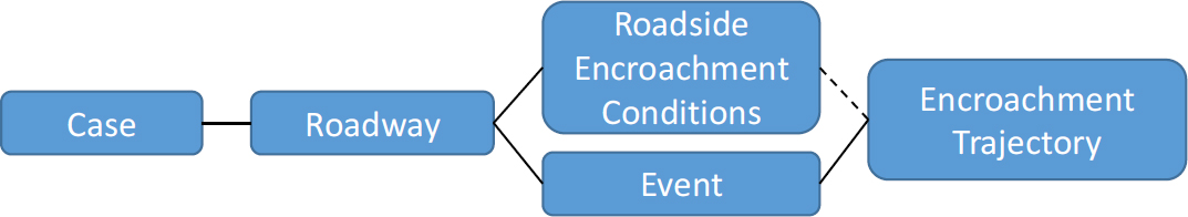
The Roadside Encroachment Conditions, Event, and Encroachment Trajectory tables are linked to both the Case and Roadway tables through the Source, CaseID, and VehNo variables. The Roadside Encroachment Conditions table will have a minimum of one case per row but will include a record for each vehicle component (cab, trailer) and each road departure or re-entry. The Event table will include one row for each event recorded per case and vehicle. Further, the Encroachment Trajectory table will build off the Event table by containing a row for each trajectory point of each event. The primary keys for the entire database are shown in Table 14.
Table 14. Primary Keys for NCHRP 17-88 Database
| Table | Primary Keys | ||||||
|---|---|---|---|---|---|---|---|
| Case | Source | CaseID | VehNo | - | - | - | - |
| Roadway | Source | CaseID | VehNo | - | - | - | - |
| Roadside Encroachment Conditions | Source | CaseID | VehNo | Component | NumDepart | - | - |
| Event | Source | CaseID | VehNo | Component | - | EventNo | - |
| Encroachment Trajectory | Source | CaseID | VehNo | Component | NumDepart | EventNo | PointNo |
Figure 5 shows how the source datasets map onto the available 17-88 ED data tables.

| GENERAL INFORMATION | DATA SOURCE |
Data Source
| Screen Name: | Data Source |
| Data Table: | All |
| Variable: | Source |
Element Attributes:
| 1 | NCHRP 17-43 |
| 2 | LTCCS |
| 3 | MCCS |
| 4 | Iowa State Data |
| 5 | Washington State Data |
| 6 | Tennessee State Data |
| 7 | SHRP 2/RID |
Source:
Identifies the source of the data used to populate the corresponding 17-88 ED case data.
Remarks:
Table 15 identifies how the data present in the 17-88 ED can be used to link to the corresponding source data. Note that not all source data are publicly available.
Table 15. Data Required to Link 17-88 ED Cases to Source Data
| Source Database | 17-88 ED Variable(s) | Source Dataset Variable(s) | Notes |
|---|---|---|---|
| SHRP 2/RID | CaseID | CaseID | Cases are identified based on the CaseID allowing linkage back to the original SHRP 2/RID database. |
| NCHRP 17-43 | CaseID + VehNo or Year, PSU, CaseNo + VehNo | CASEID + VEHNO or (Year) PSU, CaseNo + VehNo | All 17-43 cases are derived from publicly available NASS/CDS cases. Year is not a variable present in NASS/CDS but separate data files exist for each year. EDR data is available for some cases in NCHRP 17-43. |
| IA Datasets | CaseID or CaseID + VehNo | Casenumber or VEH_UNITKEY | Casenumber provides a direct link to the IA crash dataset. VEH_UNITKEY is required to match to the information present in the vehicle table and is the casenumber followed by the vehicle number. Linkage available for police-reported crashes only. |
| WA Datasets | CaseID or CaseID + VehNo | Caseno or Caseno + VEHNO | WA data obtained through the HSIS. Linkage available for police-reported crashes only. |
| TN Datasets | Year + CaseNo, or Year + CaseNo + VehNo | Caseno or caseno + vehicleno | TN crash data obtained through Electronic Tennessee Road Information System (ETRIMS). Linkage available for police-reported crashes only. |
| Source Database | 17-88 ED Variable(s) | Source Dataset Variable(s) | Notes |
|---|---|---|---|
| MCCS | CaseID + VehNo | Caseid + vehno | Cases are identified based on the CaseID and VehNo allowing linkage back to the original MCCS database. |
| NCHRP 22-26 | CaseID + VehNo or Year,, CaseNo + VehNo | CaseID + VehNo | Cases are identified based on the CaseID and VehNo. |
| LTCCS | CaseID +VehNo | CASEID + VehicleNumber or (Year) PSU, CaseNo + VehicleNumber | Cases are identified based on the CaseID and VehicleNumber allowing linkage back to the original LTCCS database. |
| GENERAL INFORMATION | VEHICLE NUMBER |
Vehicle Number
| Screen Name: | Vehicle Number |
| Data Table: | All |
| Variable: | VehNo |
Element Attributes:
| Positive integers | Vehicle number |
| -999 | Unknown |
Source:
Table 16. Populating the NCHRP 17-88 VehNo Variable
| Source Database | Data Collection Type | Variable(s) Used | Notes |
|---|---|---|---|
| SHRP 2/RID | NA | - | VehNo is not applicable. |
| NCHRP 17-43 | Direct from Source | VEHNO | VehNo = 1 for all single-vehicle crashes. Cases where the subject vehicle struck a parked vehicle were the only multiple-vehicle crashes included from NCHRP 17-43. |
| IA Datasets | Derived from Source | VEH_UNITKEY | IA VEH_UNITKEY includes the case number and vehicle number in a single data element. Only the vehicle number is retained for the VehNo variable. VehNo = 1 for all single-vehicle crashes. For multiple-vehicle crashes, vehicles are numbered same as the source data (not all vehicles from a multiple-vehicle crash are included in the 17-88 ED). Identified unreported crashes have vehicle number coded as “unknown.” |
| WA Datasets | Direct from Source | VEHNO | VehNo = 1 for all single-vehicle crashes with associated vehicle-level data. For multiple-vehicle crashes, vehicles are numbered same as the source data (not all vehicles from a multiple-vehicle crash are included in the 17-88 ED). Identified unreported crashes have vehicle number coded as “unknown.” If VehNo is missing, then there is no associated vehicle level entry for the crash. |
| TN Datasets | Direct from Source | vehicleno | VehNo = 1 for all single-vehicle crashes. No multiple-vehicle crashes included from TN as SOE information is not vehicle specific. Identified unreported crashes have vehicle number coded as “unknown.” |
| MCCS | Direct from Source | - | VehNo = 1 for all single-vehicle crashes. |
| NCHRP 22-26 | Direct from Source | - | VehNo = 1 for all single-vehicle crashes. |
| LTCCS | Direct from Source | Vehno | VehNo = 1 for all large-truck crashes. |
Remarks:
This variable assigns a number to the vehicle(s) involved in the event. The numbering for this variable follows the numbering given in the source database.
Unreported crashes identified through matching of state crash and maintenance data have vehicle number coded as “Unknown.” While the matching process can identify repairs with no corresponding police-reported crash, note that the repair could be a result of one or more than one impact to a specific roadside hardware device. For the Washington data, there can be police-reported crashes included that have no associated vehicle-level data, as most of the data needed to determine if a Washington police-reported crash should be included are present in the crash-level data table. In instances where there is crash-level data available but no associated vehicle-level data, the VehNo variable is not coded (i.e., missing/blank).
| GENERAL INFORMATION | CASE IDENTIFIER |
Case Identifier
| Screen Name: | Case Identifier |
| Data Table: | Case |
| Variable: | CaseID |
Element Attributes:
| Positive integers | Case identifier |
| -999 | Unknown |
Source:
Table 17. Populating the NCHRP 17-88 CaseID Variable
| Source Database | Data Collection Type | Variable(s) Used | Notes |
|---|---|---|---|
| SHRP 2/RID | Direct from Source | CaseID | |
| NCHRP 17-43 | Direct from Source | caseid, PSU, caseno | The caseid is assigned by NASS/CDS. The PSU is the primary sampling unit indicating the region in NASS/CDS where the case was sampled. |
| IA Datasets | Direct from Source | casenumber | Reported Crashes: Casenumber variable contains the year (4 digit) and a 6-digit case identifier. Casenumber is used directly as CaseID Unreported crashes: CaseID is the repair year followed by repair number. |
| WA Datasets | Direct from Source | Caseno | Reported Crashes: Caseno variable contains the year (4 digit) and a 5-digit case identifier. Caseno is used directly as CaseID. Unreported crashes: CaseID is the repair year followed by Record_ID. |
| TN Datasets | Derived from Source | Caseno, dateofcrash | Reported Crashes: Caseno variable contains a unique 9-digit case identifier. TN Caseno is used directly as CaseNo and the last two digits of the crash year are added to the beginning of caseno to generate CaseID. Unreported crashes: CaseID is the repair year followed by repair number. |
| MCCS | Direct from Source | CaseID variable is directly coded from MCCS. | |
| NCHRP 22-26 | Direct from Source | Case Number | CaseID variable is directly coded from NCHRP 22-26 in the form of MCxxx |
| LTCCS | Direct from Source | scaseid, PSU, caseno |
Remarks:
This variable provides the necessary information for identifying specific cases from each of the sources used to populate the 17-88 ED.
| GENERAL INFORMATION | PRIMARY SAMPLING UNIT |
Primary Sampling Unit, Case Number
| Screen Name: | Primary Sampling Units |
| Data Table: | Case |
| Variable: | PSU |
Element Attributes:
| Positive integers | primary sampling unit |
| -999 | Unknown |
Source:
Table 18. Populating the NCHRP 17-88 PSU Variable
| Source Database | Data Collection Type | Variable(s) Used | Notes |
|---|---|---|---|
| SHRP 2/RID | NA | - | PSU is not applicable. |
| NCHRP 17-43 | Direct from Source | PSU | The PSU is the primary sampling unit indicating the region in NASS/CDS where the case was sampled. |
| IA Datasets | NA | - | PSU is not applicable. |
| WA Datasets | NA | - | PSU is not applicable. |
| TN Datasets | NA | - | PSU is not applicable. |
| MCCS | NA | - | PSU is not applicable. |
| NCHRP 22-26 | NA | - | PSU is not applicable. |
| LTCCS | Direct from Source | PSU | The PSU is the primary sampling unit indicating the region in LTCCS where the case was sampled. |
Remarks:
This variable provides the necessary information for identifying specific cases from each of the sources used to populate the 17-88 ED.
| GENERAL INFORMATION | CASE NUMBER |
Case Number
| Screen Name: | Case Number |
| Data Table: | Case |
| Variable: | CaseNo |
Element Attributes:
| Positive integers | case number |
| -999 | Unknown |
Source:
Table 19. Populating the NCHRP 17-88 CaseNo Variable
| Source Database | Data Collection Type | Variable(s) Used | Notes |
|---|---|---|---|
| SHRP 2/RID | NA | - | CaseID is not applicable. |
| NCHRP 17-43 | Direct from Source | caseno | The caseno is assigned by NASS/CDS. |
| IA Datasets | Derived from Source | casenumber | Reported Crashes: Casenumber variable contains the year (4 digit) and a 6-digit case identifier. Casenumber is used directly as CaseID and the 6-digit case identifier is used as CaseNo. |
| WA Datasets | Derived from Source | Caseno | Reported Crashes: Caseno variable contains the year (4 digit) and a 5-digit case identifier. Caseno is used directly as CaseID and the 5-digit case identifier is used as CaseNo. Unreported crashes: Record_ID is used directly as CaseNo. |
| TN Datasets | Direct from Source | Caseno | Reported Crashes: Caseno variable contains a unique 9-digit case identifier. TN Caseno is used directly as CaseNo. |
| MCCS | NA | - | CaseID variable is directly coded from MCCS. There is no PSU or CaseNo assigned to MCCS cases. |
| NCHRP 22-26 | NA | - | CaseID variable is directly coded from NCHRP 22-26. There is no PSU or CaseNo assigned to NCHRP 22-26 cases. |
| LTCCS | Direct from Source | caseno | The caseno is assigned by NASS/CDS. |
Remarks:
This variable provides the necessary information for identifying specific cases from each of the sources used to populate the 17-88 ED.
| CASE TABLE | EVENT DATE |
Event Year, Month, and Day
| Screen Name: | Event Year, Event Month, Event Day |
| Data Table: | Case |
| Variable: | Year, Month, Day |
Element Attributes:
| 20XX | Calendar year |
| [1, 12] | Calendar month |
| [1, 31] | Calendar day |
| -999 | Unknown |
Source:
Table 20. Populating the NCHRP 17-88 Year, Month, and Day Variables
| Source Database | Data Collection Type | Variable(s) Used | Notes |
|---|---|---|---|
| SHRP 2/RID | NA | - | Year, Month, Day is not applicable. |
| NCHRP 17-43 | Year/Month: Direct from Source Day: NA | YEAR, MONTH | Day variable not available in 17-43. |
| IA Datasets | Derived from Source | Crash_Date | Crash_date contains the year, month, day in a single variable. Year, month, and day were extracted from Crash_date. For unreported crashes, year/month/day corresponds to the repair date noted in the maintenance record. |
| WA Datasets | Direct from Source | Accyr, month, daymth | For unreported crashes, year/month/day corresponds to the repair date noted in the maintenance record. |
| TN Datasets | Derived from Source | Dateofcrash | Dateofcrash contains the year, month, day in a single variable. Year, month, and day were extracted from dateofcrash. Month was converted from a three-letter abbreviation to the corresponding numeric value. For unreported crashes, year/month/day corresponds to the repair date noted in the maintenance record. |
| MCCS | Derived from Source | Year, Month, Day | Year, Month, and Day variables were extracted from source data table. Each known variable presented in dd/mm/yyyy format. |
| NCHRP 22-26 | Direct from Source | Crash Date | NCHRP 22-26 Crash Data variable list the day, month, and year in dd/mm/yyyy format. |
| Source Database | Data Collection Type | Variable(s) Used | Notes |
|---|---|---|---|
| LTCCS | Year: Direct from Source Month/Day: NA | SCSYear | Month and day not available in LTCCS |
Remarks:
This variable specifies the year, month, and day that the event occurred. All the in-depth crash sources (NCHRP 17-43, MCCS, NCHRP 22-26, and LTCCS), the police-reported crashes from each state, and the SHRP 2 data have event date information corresponding to the actual event based on the data available from the corresponding source. For unreported crashes from the state data sources, however, the date information corresponds to the roadside hardware device repair date. The matching of police-reported crash and available maintenance data allows an identification of unreported crashes, but the exact occurrence date of these unreported events is not known. Coding the date information as “unknown” is reserved for cases where the date information is missing from the source data (e.g., all the calendar day values for NCHRP 17-43 cases are coded as “unknown” since the calendar day of the event is not available in NASS/CDS and, thus, not available in NCHRP 17-43). Similarly, the MCCS dataset does not record the specific calendar day of the event.
| CASE TABLE | EVENT DAY OF THE WEEK |
Event Day of the Week
| Screen Name: | Event Day of the Week |
| Data Table: | Case |
| Variable: | DayOfWeek |
Element Attributes:
| 1 | Sunday |
| 2 | Monday |
| 3 | Tuesday |
| 4 | Wednesday |
| 5 | Thursday |
| 6 | Friday |
| 7 | Saturday |
| -999 | Unknown |
Source:
Table 21. Populating the NCHRP 17-88 DayofWeek Variable
| Source Database | Data Collection Type | Variable(s) Used | Notes |
|---|---|---|---|
| SHRP 2/RID | NA | - | DayOfWeek is not applicable. |
| NCHRP 17-43 | Direct from Source | DAYWEEK | DAYWEEK variable has the same format as noted above. |
| IA Datasets | Direct from Source | CRASH_DAY | CRASH_DAY variable has the same format as noted above. For unreported crashes, day corresponds to the repair date noted in the maintenance record. |
| WA Datasets | Derived from Source | Accyr, month, daymth | Year/month/day information available. This information was converted to a day of the week. For unreported crashes, day corresponds to the repair date noted in the maintenance record. |
| TN Datasets | Derived from Source | Dateofcrash | Dateofcrash contains the year, month, day in a single variable. This information was converted to a day of the week. For unreported crashes, day corresponds to the repair date noted in the maintenance record. |
| MCCS | Derived from Source | DayOfWeek | The day of the week is directly coded in MCCS but was adjusted to match the specific order in 17-88. |
| NCHRP 22-26 | Derived from Source | Crash Date | Day of week is not specified but Crash Data variable is used to determine DayofWeek. |
| Source Database | Data Collection Type | Variable(s) Used | Notes |
|---|---|---|---|
| LTCCS | NA | - | The Day of the week is not available from LTCCS |
Remarks:
This variable specifies the day of the week the event occurred. Similar to the year/month/day information, the day information for unreported crashes from the state data sources corresponds to the roadside hardware device repair date.
| CASE TABLE | EVENT TIME |
Event Hour and Minute
| Screen Name: | Event Hour, Event Minute |
| Data Table: | Case |
| Variable: | Hour, Minute |
Element Attributes:
| [0, 23] | Hour of the day in 24-hour time (00:00 – 23:59) |
| [0, 59] | Minute of the hour (00:00 – 23:59) |
| -999 | Unknown |
Source:
Table 22. Populating the NCHRP 17-88 Hour and Minute Variables
| Source Database | Data Collection Type | Variable(s) Used | Notes |
|---|---|---|---|
| SHRP 2/RID | NA | - | Hour, Minute is not applicable. |
| NCHRP 17-43 | Derived from Source | TIME | The TIME variable contains the 24-hour time (hour and minute). This data was used to populate the hour and minute variables. |
| IA Datasets | Derived from Source | TIMESTR | TIMESTR variable contains the 24-hour time (hour and minute). This data was used to populate the hour and minute variables. For unreported crashes, hour and minute are coded as unknown. |
| WA Datasets | Derived from Source | TIME | TIME variable contains the 24-hour time (hour and minute). For unreported crashes, hour and minute are coded as unknown. |
| TN Datasets | Derived from Source | timeofcrash | Timeofcrash variable contains the 24-hour time (hour and minute). This data was used to populate the hour and minute variables. A large portion of reported crashes were coded as time 0 (i.e., midnight); these were coded as unknown. For unreported crashes, hour and minute are coded as unknown. |
| MCCS | Derived from Source | Hour, Minute | The Hour variable contains the 24-hour time and the Minute variable contains the 60-minute time of each reported hour. For unreported crashes, hour and minute are coded as unknown. |
| NCHRP 22-26 | Derived from Source | Crash Time | Crash Time variable lists time of crash in 12-hour format. |
| Source Database | Data Collection Type | Variable(s) Used | Notes |
|---|---|---|---|
| LTCCS | NA | - | Hour/minute not available in LTCCS |
Remarks:
This variable specifies what time of day the event occurred. For unreported crashes, hour and minute are coded as unknown.
| CASE TABLE | EVENT REPORT STATUS |
Event Report Status
| Screen Name: | Event Report Status |
| Data Table: | Case |
| Variable: | Reported |
Element Attributes:
| 0 | No |
| 1 | Yes |
| -999 | Unknown |
Source:
Table 23. Populating the NCHRP 17-88 Reported Variable
| Source Database | Data Collection Type | Variable(s) Used | Notes |
|---|---|---|---|
| SHRP 2/RID | Researcher determined | - | All crashes in SHRP 2/RID are not police reported; Reported = 0. |
| NCHRP 17-43 | Researcher determined | - | All crashes in 17-43 are police reported; Reported = 1. |
| IA Datasets | Researcher determined | - | All suitable police-reported crashes included with Reported = 1. Maintenance records without a matching police-reported crash are included as Reported = 0. |
| WA Datasets | Researcher determined | - | |
| TN Datasets | Researcher determined | - | |
| MCCS | Researcher determined | Reported | All crashes in MCCS are police reported; Reported = 1. |
| NCHRP 22-26 | Researcher determined | - | All crashes in NCHRP 22-26 are police reported; Reported = 1. |
| LTCCS | Researcher determined | - | All crashes in LTCCS are police reported; Reported = 1. |
Remarks:
This variable specifies if the event was reported by the police. Cases where there was no impact and/or there was not a police-reported event are assigned a value of 0. Only data from the SHRP 2 and state data have unreported crashes; the remainder of the source datasets have only police-reported events.
| CASE TABLE | DRIVER DISTRACTIONS |
Driver Distraction Condition
| Screen Name: | Driver Distraction Condition |
| Data Table: | Case |
| Variable: | DriverCondition |
Element Attributes:
| 0 | No driver |
| 1 | Attentive |
| 2 | Looking elsewhere/did not see |
| 3 | Distracted by another occupant |
| 4 | Distracted by a moving object |
| 5 | Distracted by the outside |
| 6 | Talking/dialing on the phone |
| 7 | Adjusting the A/C or radio |
| 8 | Using other device |
| 9 | Sleepy |
| 10 | Eating/drinking |
| 11 | Smoking |
| 12 | Suffering from a medical condition |
| 88 | Other distraction |
| -999 | Unknown |
Source:
Table 24. Populating the NCHRP 17-88 DriverCondition Variable
| Source Database | Data Collection Type | Variable(s) Used | Notes |
|---|---|---|---|
| SHRP 2/RID | NA | - | DriverCondition is not applicable. |
| NCHRP 17-43 | Derived from Source | DRIVDIST | The categories for the DriverCondition are derived from the NASS/CDS coding manual but the values were reorganized. |
| IA Datasets | NA | - | IA data contains a driver condition variable (DRIVERCOND) that includes fatigued and medical conditions but no other “distraction” information. Given the small overlap with the 17-88 ED variable, this data was not included. |
| Source Database | Data Collection Type | Variable(s) Used | Notes |
|---|---|---|---|
| WA Datasets | Derived from Source | Contrib1, Contrib2 | Contrib variable contains information on driver distraction as well as other factors. Available data only sufficient to code attentive (1) or distracted (88) for reported crashes. Distracted includes only inattention, fatigued, and asleep; all other contributing factors are coded as attentive (1). Unreported crashes are coded as unknown. |
| TN Datasets | Derived from Source | Driverfactorsaction1-5 | Driverfactorsactions variable contains information on driver distraction as well as other factors. Available data only sufficient to code attentive (1) or distracted (88) for reported crashes. Unreported crashes are coded as unknown. |
| MCCS | Derived from Source | DriverCondition | DriverCondition describes the information on the rider distraction. |
| NCHRP 22-26 | Derived from Source/Researcher determined | Alcohol Use, and Drug Use | Alcohol Use and Drug Use variable used to determine whether the rider was under the influence. Use of crash summary to determine any other distraction variable. |
| LTCCS | Derived from Source | Inattention, Conversation, OccupantMovement, ADDDialingPhone, ADDAdjustingRadio, OtherControls, OtherInternal, ADDPreviousCrash, ApproachingTraffic, StreetAddress, ExternalPerson, Building, UnspecifiedExternal, OtherExternal | The variable Inattention describes the driver’s inattention and thought process. Conversation describes whether the driver participated in conversation with a source. OccupantMovement describes whether the driver was distracted by other occupant(s) in the vehicle. ADDDialingPhone describes whether the driver was distracted by dialing or hanging up the |
| Source Database | Data Collection Type | Variable(s) Used | Notes |
|---|---|---|---|
| phone. ADDAdjustingRadio describes whether the driver was attempting to adjust the sound system. OtherControls describes whether the driver was distracted by attempting to adjust the heat, vent, or air conditioning. OtherInternal describes whether the driver is distracted by other internal factors like smoking, eating, drinking, or reading. ADDPreviousCrash, ApproachingTraffic, StreetAddress, ExternalPerson, Building, and UnspecifiedExternal all describe whether the driver removes focus from the driving task to look at another crash, traffic, a street address, another person, building, or other located outside of the vehicle. OtherExternal describes whether the driver is distracted by something that is exterior to the vehicle that is not described by other variables. |
Remarks:
This variable describes the attentiveness of the driver at the time of the event. The variable definitions above are adapted from the NASS. If more than one condition is presented in the database of interest, the first condition listed will be coded. For the state datasets, presence of any distraction-related factors triggers the coding of “distracted.”
| CASE TABLE | DRIVER EVASIVE ACTION |
Driver Evasive Action
| Screen Name: | Driver Evasive Action |
| Data Table: | Case |
| Variable: | DriverAction |
Element Attributes:
| 0 | No impact |
| 1 | No avoidance maneuver |
| 2 | Braking without lock-up |
| 3 | Braking with lock-up |
| 4 | Braking with unknown lock-up condition |
| 5 | Releasing the brakes |
| 6 | Steering left |
| 7 | Steering right |
| 8 | Braking while steering left |
| 9 | Braking while steering right |
| 10 | Accelerating |
| 11 | Accelerating while steering left |
| 12 | Accelerating while steering right |
| 88 | Other evasive action |
| -999 | Unknown |
Source:
Table 25. Populating the NCHRP 17-88 DriverAction Variable
| Source Database | Data Collection Type | Variable(s) Used | Notes |
|---|---|---|---|
| SHRP 2/RID | NA | - | DriverAction is not applicable. |
| NCHRP 17-43 | Derived from Source | MANEUVER | The MANEUVER variable is coded closely to above. NCHRP 17-43 codes No Driver = 0, No Impact = *, and Other Action compared to what is coded above. |
| IA Datasets | NA | - | IA data does not contain any pre-crash avoidance maneuver data. |
| WA Datasets | NA | - | WA data does not contain any pre-crash avoidance maneuver data. |
| TN Datasets | NA | - | TN driver action variables do not contain |
| Source Database | Data Collection Type | Variable(s) Used | Notes |
|---|---|---|---|
| braking, steering, or other avoidance maneuvers. | |||
| MCCS | Derived from Source | DriverAction | The DriverAction variable is derived from MCCS. Motorcycle specific actions such as “Drag Feet” were coded as 88-Other evasive action. |
| NCHRP 22-26 | NA | - | NCHRP 22-26 does not contain any pre-crash avoidance maneuvers. |
| LTCCS | Derived from Source | ACRAvoidance | The ACRAvoidance variable is derived from LTCCS. The is coded similarly to above. LTCCS codes No Driver Present = 0, Other Action = 98, and Unknown = 99. |
Remarks:
This variable describes any evasive maneuver that the driver took during the event.
| CASE TABLE | INVOLVEMENT OF ANOTHER VEHICLE |
Involvement of Another Vehicle
| Screen Name: | Involvement of Another Vehicle |
| Data Table: | Case |
| Variable: | AnotherVehicle |
Element Attributes:
| 0 | No |
| 1 | Yes |
| -999 | Unknown |
Source:
Table 26. Populating the NCHRP 17-88 AnotherVehicle Variable
| Source Database | Data Collection Type | Variable(s) Used | Notes |
|---|---|---|---|
| SHRP 2/RID | NA | - | AnotherVehicle is not applicable. |
| NCHRP 17-43 | Researcher Determined | - | Determined if another vehicle influenced the trajectory based on the NASS/CDS crash summary and crash scene diagram. |
| IA Datasets | Derived from Source | vehicles | All crashes with vehicles > 1 coded as AnotherVehicle = 1. If a single-vehicle crash had a phantom vehicle present in the vehicle table, then AnotherVehicle was also coded as 1. |
| WA Datasets | Derived from Source | numvehs | All crashes with numvehs > 1 coded as AnotherVehicle = 1. If a single-vehicle crash had a phantom vehicle present in the vehicle table, then AnotherVehicle was also coded as 1. |
| TN Datasets | Derived from Source | totalvehicles | Only TN single-vehicle crashes included. If a single-vehicle crash had a phantom vehicle present in the vehicle table, then AnotherVehicle was also coded as 1. |
| MCCS | Researcher Determined | AnotherVehicle | Determined if another vehicle influenced the trajectory based on the MCCS crash scene diagram. |
| NCHRP 22-26 | Researcher Determined | - | Use of scaled scene diagram and crash summary used to determine if another vehicle was involved in the crash. |
| LTCCS | Researcher Determined | - | Determined if another vehicle influenced the trajectory based on the LTCCS crash summary and crash scene diagram. |
Remarks:
This variable specifies if another vehicle (V2) influenced the trajectory of the encroaching vehicle (V1) or if another vehicle was struck. For example, AnotherVehicle = 1 would be coded for situations including, but not limited to, the following:
- V1 attempts to pass V2 (Figure 6).
- V2 abruptly brakes in front of V1, causing V1 to perform an evasive maneuver.
- V1 strikes V2, a parked vehicle.
- V1 strikes V2, a moving vehicle.
Note: For most cases, this information is not known, so AnotherVehicle = -999. However, a crash does not necessarily have to occur for AnotherVehicle = 1.

| CASE TABLE | INTENTIONAL ROAD DEPARTURE |
Intentional Road Departure
| Screen Name: | Intentional Road Departure |
| Data Table: | Case |
| Variable: | IntentionalDep |
Element Attributes:
| 0 | No |
| 1 | Yes |
| -999 | Unknown |
Source:
Table 27. Populating the NCHRP 17-88 IntentionalDep Variable
| Source Database | Data Collection Type | Variable(s) Used | Notes |
|---|---|---|---|
| SHRP 2/RID | NA | - | IntentionalDep is not applicable. |
| NCHRP 17-43 | Researcher Determined | - | Determined driver intentionally left the road based on the NASS/CDS crash summary. |
| IA Datasets | NA | - | Data not available from the state datasets |
| WA Datasets | |||
| TN Datasets | |||
| MCCS | NA | IntentionalDep | Data not available from the MCCS because there is no crash summary. |
| NCHRP 22-26 | Researcher Determined | - | Determined driver intentionally left the road based on the NCHRP 22-26 crash summary. |
| LTCCS | Researcher Determined | - | Determined driver intentionally left the road based on the LTCCS crash summary. |
Remarks:
This variable specifies if the encroaching vehicle (V1) intentionally left its lane of travel based on the crash narrative. IntentionalDep = 1 would be coded for situations including, but not limited to, the following:
- V1 passes another vehicle on the shoulder.
- V1 intentionally drives on the shoulder to avoid an object on the road.
| CASE TABLE | ABBREVIATED INJURY SCALE |
Abbreviated Injury Scale Rating
| Screen Name: | Abbreviated Injury Scale Rating |
| Data Table: | Case |
| Variable: | AIS |
Element Attributes:
| 0 | None |
| 1 | Minor |
| 2 | Moderate |
| 3 | Serious |
| 4 | Severe |
| 5 | Critical |
| 6 | Maximum |
| -999 | Unknown |
Source:
Table 28. Populating the NCHRP 17-88 AIS Variable
| Source Database | Data Collection Type | Variable(s) Used | Notes |
|---|---|---|---|
| SHRP 2/RID | NA | - | AIS is not applicable. |
| NCHRP 17-43 | Direct from Source | AIS | This is coded based on the 2008 Abbreviated Injury Scale. |
| IA Datasets | NA | - | Detailed AIS injury data not available for the state data. |
| WA Datasets | |||
| TN Datasets | |||
| MCCS | Direct from Source | AIS | This is coded based on the 2005 Abbreviated Injury Scale. |
| NCHRP 22-26 | Direct from Source | MAIS | MAIS variable is coded the same as above. |
| LTCCS | Derived from Source | AISCODE | The variable AISCODE represents the severity of an injury. For LTCCS, AISCODE lists an injury with multiple number describing the specific injury, and the last digit following from similar coding as above with AISCODE with a 7 as the last digit meaning a traumatic injury. |
Remarks:
This variable describes the injury severity of the driver according to the Abbreviated Injury Scale (AIS).
| CASE TABLE | KABCO INJURY SCALE |
KABCO Injury Scale Rating
| Screen Name: | KABCO Injury Scale Rating |
| Data Table: | Case |
| Variable: | KABCO |
Element Attributes:
| 1 | K – Fatal |
| 2 | A – Incapacitating injury |
| 3 | B – Non-incapacitating injury |
| 4 | C – Possible injury |
| 5 | O – No injury |
| -999 | Unknown |
Source:
Table 29. Populating the NCHRP 17-88 KABCO Variable
| Source Database | Data Collection Type | Variable(s) Used | Notes |
|---|---|---|---|
| SHRP 2/RID | NA | - | KABCO is not applicable. |
| NCHRP 17-43 | NA | - | The police-reported KABCO severity was not recorded in NCHRP 22-26. |
| IA Datasets | Direct from Source | ZINJ_INJSTATUS | Injury data also available for other vehicle occupants involved in the crash |
| WA Datasets | Direct from Source | DRV_INJ | Injury data also available for the most severely injured occupant in the crash (SEVERITY) |
| TN Datasets | Direct from Source | TYPEOFCRASH, PERSONINJURYCODE | TYPEOFCRASH used to classify injury for the entire single-vehicle crash. The TN codes do not include a “possible injury” option so this is excluded. Injury data also available for other crash-involved vehicle occupants (PERSONINJURYCODE). |
| MCCS | NA | - | The police-reported KABCO severity was not recorded in MCCS. |
| NCHRP 22-26 | NA | - | The police-reported KABCO severity was not recorded in NCHRP 22-26. |
| LTCCS | Derived from Source | GVEPARSevCode, GVERESSevCode | The variable GVEPARSevCode represents the highest injury severity based on Police Accident Report (PAR). The variable GVERESSevCode represents that highest injury severity based on |
| Source Database | Data Collection Type | Variable(s) Used | Notes |
|---|---|---|---|
| medical records. Both GVEPARSevCode and GVERESSevCode are coded the same but are coded differently than above, Unknown = 9, Died Prior to Crash = 6, U – Injury, Severity Unknown = 5, K – Fatal = 4, A – Incapacitating injury = 3, B – Non-incapacitating injury = 2, C – Possible injury = 1, O – No injury = 0. |
Remarks:
This variable describes the injury severity of the driver according to the KABCO Injury Scale.
| CASE TABLE | WEATHER |
Weather
| Screen Name: | Weather |
| Data Table: | Case |
| Variable: | Weather |
Element Attributes:
| 1 | Clear/Cloudy |
| 2 | Rain |
| 3 | Sleet/hail |
| 4 | Snow |
| 5 | Fog |
| 6 | Rain and fog |
| 7 | Sleet/hail and fog |
| 88 | Other |
| -999 | Unknown |
Source:
Table 30. Populating the NCHRP 17-88 Weather Variable
| Source Database | Data Collection Type | Variable(s) Used | Notes |
|---|---|---|---|
| SHRP 2/RID | NA | - | Weather is not applicable. |
| NCHRP 17-43 | Derived from Source | WEATHER | The Weather variable contains similar but not exactly the same categories as those listed above. Clear and cloudy are coded as Weather = 1. Snow and blowing snow are combined and coded as Weather = 4. Freezing rain and sleet/hail are combined and coded as Weather = 3. All other categories coded as Weather = 88 or Weather = -999. |
| IA Datasets | Derived from Source | WEATHER | For reported crashes, Weather variable contains similar but not exactly the same categories as those listed above. Clear and cloudy are coded as Weather = 1. Snow and blowing snow are combined and coded as Weather = 4. Freezing rain and sleet/hail are combined and coded as Weather = 3. All other categories coded as Weather = 88 or Weather = -999 (if not reported). Surface condition information not available for unreported crashes. |
| WA Datasets | Derived from Source | WEATHER | For reported crashes, Weather variable contains similar but not exactly the same categories as those listed above. Clear and overcast are coded as Weather = 1. |
| Source Database | Data Collection Type | Variable(s) Used | Notes |
|---|---|---|---|
| Fog/smog/smoke and foggy combined and coded as Weather = 5. Raining, snowing, and sleet/hail categories are coded as such. All other categories coded as Weather = 88 or Weather = -999 (if reported as unknown). Surface condition information not available for unreported crashes. | |||
| TN Datasets | Derived from Source | weatherconditions | For reported crashes, weatherconditions variable contains similar but not exactly the same categories as those listed above. Clear and cloudy are coded as Weather = 1. Snow and blowing snow are combined and coded as Weather = 4. Fog and smog/smoke are combined and coded as Weather = 5. All other categories coded as Weather = 88 or Weather = -999 (if not reported or reported as unknown). Surface condition information not available for unreported crashes. |
| MCCS | Derived from Source | Weather | The Weather variable contains similar but not exactly the same categories as those listed above. Clear, cloudy, and overcast are coded as Weather = 1. Snow is coded as Weather = 4. Sleet and hail are combined and coded as Weather = 3. Light rain and Heavy rain are combined as Weather = 2. All other categories coded as Weather = 88 or Weather = -999 if unknown |
| NCHRP 22-26 | Direct from Source | Conditions | Conditions variable lists weather, lighting, and surface conditions. |
| LTCCS | Derived from Source | ENVNoConditions, ENVRain, ENVSnow, ENVFog, ENVWindGusts, ENVHail, ENVSleet, ENVDust, and ENVOtherConditions | LTCCS classifies weather conditions under 9 different variables. Each variable is coded as present=1 and absent=0. |
Remarks:
This variable describes the weather conditions during the event.
| CASE TABLE | ROADWAY LIGHTING |
Roadway Lighting
| Screen Name: | Roadway Lighting |
| Data Table: | Case |
| Variable: | Lighting |
Element Attributes:
| 1 | Daylight |
| 2 | Dark without illumination |
| 3 | Dark with illumination |
| 4 | Dawn |
| 5 | Dusk |
| -999 | Unknown |
Source:
Table 31. Populating the NCHRP 17-88 Lighting Variable
| Source Database | Data Collection Type | Variable(s) Used | Notes |
|---|---|---|---|
| SHRP 2/RID | NA | - | Lighting is not applicable. |
| NCHRP 17-43 | Direct from Source | LGTCOND | NCHRP 17-43 reports lighting conditions under 5 different conditions. Daylight is coded as LGTCOND = 1, Dark w/o Lighted is coded as LGTCOND = 2, Dark w/Lighted is coded as LGTCOND = 3, Dawn is coded as LGTCOND = 4, Dusk is coded as LGTCOND = 5. Unknown light conditions are coded as -999. |
| IA Datasets | Direct from Source | LIGHT | For reported crashes, the LIGHT variable has very similar categories to those listed above. Dark – unknown roadway lighting, not reported, and Unknown are combined and coded as Lighting = -999. No data available for unreported crashes. |
| WA Datasets | Direct from Source | LIGHT | For reported crashes, the LIGHT variable has very similar categories to those listed above. Dark – street lights off and dark, no street lights are combined and coded as Lighting = 2. Other and unknown are combined and coded as Lighting = -999. No data available for unreported crashes. |
| TN Datasets | Direct from Source | Lightconditions | For reported crashes, the lightconditions variable has very similar categories to those listed |
| Source Database | Data Collection Type | Variable(s) Used | Notes |
|---|---|---|---|
| above. Dark – unknown roadway lighting, Other, and unknown are combined and coded as Lighting = -999. No data available for unreported crashes. | |||
| MCCS | Derived from Source | Lighting | The Lighting has very similar categories to those listed above. Daylight, bright and Daylight, not bright are combined to Lighting = 1. Dark – street lights off and dark, no street lights are combined and coded as Lighting = 2. Dark roadways with lighting is coded as Lighting = 3. Dawn is coded as Lighting = 4 and Dusk is coded as Lighting = 5. All others and unknowns are coded as Lighting = -999. |
| NCHRP 22-26 | Direct from Source | Conditions | Conditions variable lists weather, lighting, and surface conditions. |
| LTCCS | Derived from Source | Daylight | LTCCS reports lighting conditions under 6 different conditions, all of which are the same as listed above. |
Remarks:
This variable describes the roadway lighting during the event.
| CASE TABLE | VEHICLE TYPE |
Vehicle Type
| Screen Name: | Vehicle Type |
| Data Table: | Case |
| Variable: | VehType |
Element Attributes:
| 0 | Not a motor vehicle |
| 1 | Passenger Vehicle |
| 2 | Utility Vehicle |
| 3 | Motorcycle |
| 4 | Pickup Truck |
| 5 | Bus |
| 6 | Large Truck |
| 7 | Tractor Trailer |
| 8 | Van |
| 88 | Other |
| -999 | Unknown |
Source:
Table 32. Populating the NCHRP 17-88 VehType Variable
| Source Database | Data Collection Type | Variable(s) Used | Notes |
|---|---|---|---|
| SHRP 2/RID | NA | - | VehType is not applicable. |
| NCHRP 17-43 | Derived from Source | BODYTYPE | The applicable coding is as follows: When BODYTYPE= 1, 2, 3, 4, 5, 6, 7, or 17, VehType = 1. When BODYTYPE = 14, 15, 16, or 19, VehType = 2. When BODYTYPE = 30, 31, 32, 33, or 39, VehType = 4. When BODYTYPE = 20, 21, 22, 23, 24, 25, 28, or 29, VehType = 8. When BODYTYPE = 8 or 11, VehType = 88. When BODYTYPE = 9 or 99, VehType = -999. Any additional cases that do not fit these criteria are coded as VehType = 88. |
| IA Datasets | Derived from source | ||
| WA Datasets | Derived from source | ||
| TN Datasets | Derived from source | ||
| MCCS | Derived from Source/Researcher Determined | All cases in MCCS involve motorcycles and are coded as VehType = 3. |
| Source Database | Data Collection Type | Variable(s) Used | Notes |
|---|---|---|---|
| NCHRP 22-26 | Researcher Determined | - | Using the given case summary, the researcher was able to indicate the vehicle type. |
| LTCCS | Derived from Source | GVEBodyType | All cases in LTCCS involve large trucks/tractor trailers and are coded as VehType = 6 or 7. When GVEBodyType = 61, 62, 63, or 64, VehType = 6. When GVEBodyType = 66, 67, 68, or 69, VehType = 7. |
Remarks:
This variable captures the type of vehicle involved in the case.
| CASE TABLE | RAMP PRESENT |
Ramp Present
| Screen Name: | Ramp Present |
| Data Table: | Case |
| Variable: | Ramp |
Element Attributes:
| 0 | No |
| 1 | Yes |
| -999 | Unknown |
Source:
Table 33. Populating the NCHRP 17-88 RampOcc Variable
| Source Database | Data Collection Type | Variable(s) Used | Notes |
|---|---|---|---|
| SHRP 2/RID | NA | - | Ramp is not applicable. |
| NCHRP 17-43 | Derived from Source | RELINTER | If RELINTER = 1, then Ramp = 1. All other values are not interchange related and coded as Ramp = 0. |
| IA Datasets | Derived from Source | ||
| WA Datasets | Derived from Source | RD_INV and ROAD_INV | For mainline sections, RD_INV and ROAD_INV match the route number (i.e., Ramp = 0). Otherwise, Ramp = 1. |
| TN Datasets | Derived from Source | ||
| MCCS | Researcher Determined | - | Determined using the available crash scene diagram. |
| NCHRP 22-26 | Researcher Determined | - | Determined using the available crash scene diagram and case summary. |
| LTCCS | Derived from Source | Junction | If Junction = 5, 15, or 19, then Ramp = 1. All other values are not interchange related and coded as Ramp = 0. |
Remarks:
This variable specifies whether the vehicle first departed on a ramp or a mainline roadway segment.
| CASE TABLE | ROLLED OVER |
Rolled Over
| Screen Name: | Rolled Over |
| Data Table: | Case |
| Variable: | Rolled |
Element Attributes:
| 0 | No |
| 1 | Yes |
| 88 | Other |
| -999 | Unknown |
Source:
Table 34. Populating the NCHRP 17-88 Rolled Variable
| Source Database | Data Collection Type | Variable(s) Used | Notes |
|---|---|---|---|
| SHRP 2/RID | NA | - | Rolled is not applicable. |
| NCHRP 17-43 | Derived from Source | - | The “Rollover” variable in NASS/CDS was used to indicate whether a rollover occurred at any point of the crash. |
| IA Datasets | Derived from Source | - | The “SEQEVENTS1 – 4” variable was used to indicate whether a rollover occurred at any point of the crash. |
| WA Datasets | Derived from Source | - | The “EVENT1-4” variable was used to indicate whether a rollover occurred at any point of the crash. |
| TN Datasets | Derived from Source | - | The “EVENT_SEQ1 – 10” was used to indicate whether a rollover occurred at any point of the crash. |
| MCCS | Derived from Source | - | The Rollover variable is used to determine if a rollover was present at the crash. |
| NCHRP 22-26 | Derived from Source | - | Use of scaled scene diagram and crash summary used to determine if the motorcycle experienced a rollover. Riders and passengers coded as 88. |
| LTCCS | Derived from Source | - | The RolloverType variable is used to determine if a rollover was present at the crash. |
Remarks:
This variable specifies if the vehicle or vehicle component rolled over during the event. In the CDS crash scene diagram, vehicles that have rolled over are indicated with trajectory points that are on the vehicle side or roof.
| CASE TABLE | WORK ZONE PRESENCE |
Work Zone Presence
| Screen Name: | Work Zone Presence |
| Data Table: | Roadway |
| Variable: | Workzone |
Element Attributes:
| 0 | No, a work zone was not present at time of event |
| 1 | Yes, a work zone was present at time of event |
| -999 | Unknown |
Source:
Table 35. Populating the NCHRP 17-88 Workzone Variable
| Source Database | Data Collection Type | Variable(s) Used | Notes |
|---|---|---|---|
| SHRP 2/RID | NA | - | Workzone is not applicable. |
| NCHRP 17-43 | Researcher determined | - | Determined using available crash narrative along with the available crash scene photographs. |
| IA Datasets | Derived from Source | WZRELATED | IA denotes the type of work zone (lane closure, shoulder work, etc.) – all of these are coded as Workzone = 1. Missing values denoting no work zone; missing values are coded Workzone = 0. |
| WA Datasets | Derived from Source | WKZONE | WA denotes several types of work zone conditions (workers present, no workers present, etc.) – all of these are coded as Workzone = 1. If data is missing, Workzone = 0. WA has reported issues with officers noting “workers not present” (i.e., in a work zone) for the case where there is no work zone present. |
| TN Datasets | Derived from Source | highwayconstructionzone | TN denotes location within a work zone – all of these are coded as Workzone = 1. If data is missing, Workzone = 0. |
| MCCS | Direct from Source | WorkZone | MCCS indicates whether the crash occurred in a work zone and is coded as WorkZone = 1. If the work zone is absent, it is coded as WorkZone = 0. |
| NCHRP 22-26 | Researcher Determined | - | Determined using available crash scene diagram/crash narrative along |
| Source Database | Data Collection Type | Variable(s) Used | Notes |
|---|---|---|---|
| with the available crash scene photographs. | |||
| LTCCS | Direct from Source | ConstructionZone | LTCCS denotes locations of traffic flow that are interrupted as a result of the crash being in a construction zone. If a work zone is present, it is coded as ConstructionZone=1, and if the work zone is absent, it is coded as ConstructionZone=0. |
Remarks:
This variable specifies if the event occurred in a construction work zone.
| CASE TABLE | LAND DEVELOPMENT TYPE |
Road Surface Condition
| Screen Name: | Road Surface Condition |
| Data Table: | Roadway |
| Variable: | SurfaceCondition |
Element Attributes:
| 1 | Dry |
| 2 | Wet |
| 3 | Frozen |
| 4 | Snow |
| 88 | Other |
| -999 | Unknown |
Source:
Table 36. Populating the NCHRP 17-88 SurfaceCondition Variable
| Source Database | Data Collection Type | Variable(s) Used | Notes |
|---|---|---|---|
| SHRP 2/RID | NA | - | SurfaceCondition is not applicable. |
| NCHRP 17-43 | Derived from Source | SurCond | NCHRP 17-43 classifies 10 different surface conditions. Dry is coded as SurCond = 1, Wet is coded as SurCond = 2, Snow is coded as SurCond = 3, Slush is coded as SurCond = 4, Ice is coded as SurCond = 5, Water (standing, moving) is coded as SurCond = 6, Sand is coded as SurCond = 7, Dirt, mud or gravel is coded as SurCond = 8, Oil is coded as SurCond = 9, Other is coded as SurCond = 88, and Unknown is coded as -999. |
| IA Datasets | Direct from Source | CSRFCND | CSRFCND variable contains the same 4 categories listed above in addition to “Mud” (coded as 88). Surface condition information not available for unreported crashes. |
| WA Datasets | Direct from Source | RDSURF | RDSURF variable contains the same 4 categories listed above as well as others (all others coded as 88). Surface condition information not available for unreported crashes. |
| TN Datasets | Direct from Source | roadwaysurfaceconditions | Roadwaysurfaceconditions variable contains the same categories listed above as well as others (all others coded as 88). Surface condition information not available for unreported crashes. |
| Source Database | Data Collection Type | Variable(s) Used | Notes |
|---|---|---|---|
| MCCS | Derived from Source | SurfaceCondition | SurfaceCondition contains these four common elements. Additional data codes for less common roadway conditions are coded as “Other.” All unknowns were coded as SurfaceCondition = -999. |
| NCHRP 22-26 | Direct from Source | Conditions | Conditions variable lists weather, lighting, and surface conditions. |
| LTCCS | Derived from Source | SurfaceConditions | LTCCS classifies 7 different surface conditions. Dry is coded as SurfaceConditions = 1, Wet is coded as SurfaceConditions = 2, Snow or Slush is coded as SurfaceConditions = 3, Ice is coded as SurfaceConditions = 4, Sand, Dirt, or Oil are coded as SurfaceConditions = 5, Other is coded as SurfaceConditions = 8, and Unknown is coded as SurfaceConditions = 9. |
Remarks:
This variable describes the condition of the roadway surface. This may differ from the condition of the roadside; for example, the road may have normal conditions, but the roadside is covered in snow.
| CASE TABLE | TRAILER PRESENCE |
Trailer Present
| Screen Name: | Trailer Presence |
| Data Table: | Case |
| Variable: | Trailer |
Element Attributes:
| 0 | No Trailer |
| 1 | Trailer |
| -998 | Not applicable |
| -999 | Unknown |
Source:
Table 37. Populating the NCHRP 17-88 Trailer Variable
| Source Database | Data Collection Type | Variable(s) Used | Notes |
|---|---|---|---|
| SHRP 2/RID | NA | - | Trailer is not applicable. |
| NCHRP 17-43 | NA | - | Trailer data is not available for NCHRP 17-43 dataset. |
| IA Datasets | Derived from Source | Vconfig, CargoBody | For reported crashes, if Vconfig < 10 and CargoBody reported as code 13-16, Trailer coded as 1. Unreported crashes coded as unknown. |
| WA Datasets | Derived from Source | VEHTYPE, VEH_USE | For reported crashes, if VEHTYPE is a passenger vehicle and VEH_USE = 23 to 25, then Trailer coded as 1. Unreported crashes coded as unknown. |
| TN Datasets | Derived from Source | VEHICLETRAILER | VEHICLETRAILER = 1 through 6 coded as Trailer = 1. Unreported crashes coded as unknown. |
| MCCS | NA | - | Trailer data is not available for MCCS dataset. |
| NCHRP 22-26 | Researcher Determined | - | Determined using the available crash summary and scene diagram. |
| LTCCS | Researcher Determined | - | Determined using the available crash summary and scene diagram. |
Remarks:
This variable indicates if a vehicle is towing a trailer.
| ROADWAY TABLE | ROADWAY IDENTIFIER |
Road Identifier
| Screen Name: | Road Identifier |
| Data Table: | Roadway |
| Variable: | RoadID |
Element Attributes:
| Text entry | Road identifier |
| -999 | Unknown |
Source:
Table 38. Populating the NCHRP 17-88 RoadID Variable
| Source Database | Data Collection Type | Variable(s) Used | Notes |
|---|---|---|---|
| SHRP 2/RID | NA | - | Specific crash location information is not available from this source data. |
| NCHRP 17-43 | NA | - | Specific crash location information is not available from this source data. |
| IA Datasets | Direct from Source | Route | All routes included from these sources are state-level routes. |
| WA Datasets | Direct from Source | Rte_nbr | |
| TN Datasets | Direct from Source | nbr_rte | |
| MCCS | NA | - | Specific crash location information is not available from this source data. |
| NCHRP 22-26 | NA | - | Specific crash location information is not available from this source data. |
| LTCCS | NA | - | Specific crash location information is not available from this source data. |
Remarks:
This variable provides the road designation where the event occurred.
| ROADWAY TABLE | ROAD MILEPOST |
Road Milepost
| Screen Name: | Road Milepost |
| Data Table: | Roadway |
| Variable: | RoadMP |
Element Attributes:
| x > 0 | Roadway reference location (miles) |
| -999 | Unknown |
Source:
Table 39. Populating the NCHRP 17-88 RoadMP Variable
| Source Database | Data Collection Type | Variable(s) Used | Notes |
|---|---|---|---|
| SHRP 2/RID | NA | - | RoadMP is not applicable. |
| NCHRP 17-43 | NA | - | Specific crash location information is not available from this source data. RoadMP coded as -999. |
| IA Datasets | Direct from Source | Route | All routes included from these sources are state-level routes. |
| WA Datasets | Direct from Source | Rte_nbr | |
| TN Datasets | Direct from Source | Log_mle | |
| MCCS | NA | - | Specific crash location information is not available from this source data. |
| NCHRP 22-26 | NA | - | Specific crash location information is not available from this source data. |
| LTCCS | NA | - | Specific crash location information is not available from this source data. |
Remarks:
This variable provides the roadway milepost where the event occurred.
| ROADWAY TABLE | ROAD ACCESS LEVEL |
Road Access Level
| Screen Name: | Road Access Level |
| Data Table: | Roadway |
| Variable: | AccessControl |
Element Attributes:
| 0 | No access control |
| 1 | Partial access control |
| 2 | Full access control |
| -999 | Unknown |
Source:
Table 40. Populating the NCHRP 17-88 AccessControl Variable
| Source Database | Data Collection Type | Variable(s) Used | Notes |
|---|---|---|---|
| SHRP 2/RID | NA | - | AccessControl is not applicable. |
| NCHRP 17-43 | Researcher Determined | - | Crash summary and scene photos used to determine access control level (see further details in remarks section below). Coded as unknown if not sufficient information available to determine. |
| IA Datasets | Derived from Source | Access_Control | IA identifies 4 different access control levels (interstate/freeway, expressway, planned with thru traffic given preference, planned with all traffic considered). Interstate/Freeway was coded as 2 and planned with all traffic considered coded as 0. The other two levels were coded as 1. |
| WA Datasets | Derived from Source | Access | WA HSIS identifies 6 different access control levels (no access control not identified). Fully controlled access is coded as AccessControl = 2. All others coded as AccessControl = 1. |
| TN Datasets | Direct from Source | Access_ctrl | TN accessctrl indicates the same categories with the same code values. |
| MCCS | Direct From Source | AccessControl | MCCS identifies 4 different access control levels (No Control, Partial Control, Full Control, and Unknown). No Control is coded as AccessControl = 0, Partial Control as AccessControl = 1, Full Control as AccessControl = 2, and Unknown as -999. |
| Source Database | Data Collection Type | Variable(s) Used | Notes |
|---|---|---|---|
| NCHRP 22-26 | Researcher Determined | - | Crash summary and scene photos used to determine access control level (see further details in remarks section below). Coded as unknown if not sufficient information available to determine. |
| LTCCS | Direct from Source | AccessControl | LTCCS identifies 4 different access control levels (Full Control, No Control, Other (Specify), and Unknown). Fully control is coded as AccessControl=1, No Control is coded as AccessControl=2, Other is coded as AccessControl=3, and Unknown is coded as AccessControl=9. |
Remarks:
This variable describes the degree of access to the roadway. Unlike the other datasets, this is not directly coded in NASS/CDS. The following criteria were used to estimate access control based on the scene photographs in NASS/CDS.
- No access control should be indicated when no interchanges or exit ramps appear before at-grade crossings, driveways, or connections to other roadways. Drivers may immediately access new roadways from their traveled way.
- Partial access control should be indicated when there are some at-grade road crossings, driveways, or connections, but these are minimized.
- Full access control should be indicated when at-grade crossings, driveways, or connections are fully blocked from immediate access along the traveled way. Any connections to other roadways are done only via interchanges or exit ramps. For example, an interstate highway has full access control.
| ROADWAY TABLE | ROAD ACCESS DENSITY |
Road Access Density
| Screen Name: | Road Access Density |
| Data Table: | Roadway |
| Variable: | AccessDensity |
Element Attributes:
| Positive numbers | Road access density |
| -999 | Unknown |
Source:
Table 41. Populating the NCHRP 17-88 AccessDensity Variable
| Source Database | Data Collection Type | Variable(s) Used | Notes |
|---|---|---|---|
| SHRP 2/RID | NA | - | AcccessDensity is not applicable. |
| NCHRP 17-43 | NA | - | Access density information is not available from this source data. |
| IA Datasets | NA | - | Access density information is not available from this source data. |
| WA Datasets | NA | - | Data not present in WA HSIS Crash/Roadway data. WA highway log file for corresponding year could be used to compute access density surrounding crash location. |
| TN Datasets | NA | - | Access density information is not available from this source data. |
| MCCS | NA | - | Access density information is not available from this source data. |
| NCHRP 22-26 | NA | - | Access density information is not available from this source data. |
| LTCCS | NA | - | Access density information is not available from this source data. |
Remarks:
This variable specifies the number of road access points per kilometer of roadway with each roadside counted separately. For example, a cross street counts as two access points.
| ROADWAY TABLE | GLOBAL COORDINATES |
Lateral and Longitudinal Global Coordinate
| Screen Name: | Lateral Global Coordinate, Longitudinal Global Coordinate |
| Data Table: | Roadway |
| Variable: | LocationLat, LocationLong |
Element Attributes:
| [-90, 90] | Latitude coordinate of the event (degrees) |
| [-180, 180] | Longitude coordinate of the event (degrees) |
| -999 | Unknown |
Source:
Table 42. Populating the NCHRP 17-88 LocationLat and LocationLong Variables
| Source Database | Data Collection Type | Variable(s) Used | Notes |
|---|---|---|---|
| SHRP 2/RID | NA | - | LocationLat and LocationLong are not applicable. |
| NCHRP 17-43 | NA | - | Specific crash location information is not available from this source data. |
| IA Datasets | Direct from Source | X (longitude), Y (latitude) | |
| WA Datasets | NA | - | Specific crash location information (in the form of a GPS location) is not available from this source data. |
| TN Datasets | Direct from Source | gpscoordinatelat, gpscoordinatelong | |
| MCCS | NA | - | Specific crash location information is not available from this source data. |
| NCHRP 22-26 | NA | - | Specific crash location information is not available from this source data. |
| LTCCS | NA | - | Specific crash location information is not available from this source data. |
Remarks:
This variable specifies the location of the event in terms of its global coordinates in degrees latitude and degrees longitude.
| ROADWAY TABLE | DIRECTION OF TRAVEL |
Direction of Travel
| Screen Name: | Direction of Travel |
| Data Table: | Roadway |
| Variable: | Direction |
Element Attributes:
| 1 | North |
| 2 | North-East |
| 3 | East |
| 4 | South-East |
| 5 | South |
| 6 | South-West |
| 7 | West |
| 8 | North-West |
| -999 | Unknown |
Source:
Table 43. Populating the NCHRP 17-88 Direction Variable
| Source Database | Data Collection Type | Variable(s) Used | Notes |
|---|---|---|---|
| SHRP 2/RID | NA | - | Direction is not applicable. |
| NCHRP 17-43 | Researcher Determined | - | The available crash summary and scene diagram is used to manually code this data for each case. The scene diagram should be examined when determine the direction of travel, not the road designation. For example, a short segment of I-495 south in Springfield, Virginia temporarily travels east. For this scenario, Direction = 3. |
| IA Datasets | Direct from Source | Cardinal_Direction_of_Vehicles | Vehicle direction only coded per crash, not per vehicle. |
| WA Datasets | Direct from Source | V1cmpdir, V2cmpdir | WA HSIS has data on travel directions for two vehicles (same 8 categories as listed above). For single-vehicle crashes, V1cmpdir is used. For vehicles from multiple-vehicle crashes, the direction is based on vehicle number. For vehicles other than vehicle 1 or vehicle 2, this is coded as -999. |
| Source Database | Data Collection Type | Variable(s) Used | Notes |
|---|---|---|---|
| TN Datasets | Direct from Source | VEHICLEGOINGONDIRECTION | TN data only has 4 data element attributes for this data element (N, E, S, W). Codes 2, 4, 6, and 8 not coded for TN data. |
| MCCS | Researcher Determined | Direction | The available crash summary and scene diagram is used to manually code this data for each case. The scene diagram should be examined when determine the direction of travel, not the road designation. |
| NCHRP 22-26 | Researcher Determined | - | The available crash summary and scene diagram is used to manually code this data for each case. The scene diagram should be examined when determine the direction of travel, not the road designation. |
| LTCCS | Researcher Determined | - | The available crash summary and scene diagram is used to manually code this data for each case. The scene diagram should be examined when determine the direction of travel, not the road designation. |
Remarks:
This variable specifies the vehicle’s compass direction of travel prior to the event.
| ROADWAY TABLE | POSTED SPEED LIMIT |
Posted Speed Limit
| Screen Name: | Posted Speed Limit |
| Data Table: | Roadway |
| Variable: | PostSpeed |
Element Attributes:
| 0 | None |
| x > 0 | Speed limit (kph) |
| -999 | Unknown |
Source:
Table 44. Populating the NCHRP 17-88 PostSpeed Variable
| Source Database | Data Collection Type | Variable(s) Used | Notes |
|---|---|---|---|
| SHRP 2/RID | Direct from Source | SpeedLimit | SpeedLimit establishes the pre-crash roadway’s posted speed in mph |
| NCHRP 17-43 | Direct from Source | SPLIMIT | SPLIMIT establishes the pre-crash roadway’s posted speed limit in kph. |
| IA Datasets | Direct from Source | SPEED_LIMIT | Posted speed converted from mph to kph. |
| WA Datasets | Spd_limt | ||
| TN Datasets | spd_lmt | ||
| MCCS | Direct from Source | PostSpeed | Posted speed converted from mph to kph. |
| NCHRP 22-26 | Direct from Source | - | Scene diagram included posted speed limit in kph. |
| LTCCS | Direct from Source | ADAPostedSpeed, GVEPostedSpeed | ADAPostedSpeed establishes the pre-crash roadway’s posted speed limit in kph. GVEPostedSpeed establishes the posted speed limit in effect for the crash location in kph. |
Remarks:
This variable specifies the speed limit where the event occurred in kilometers per hour. The posted speed limit is the maximum legal speed that a vehicle can travel on a road segment.
| ROADWAY TABLE | ADVISORY SPEED |
Advisory Speed
| Screen Name: | Advisory Speed |
| Data Table: | Roadway |
| Variable: | AdvisorySpeed |
Element Attributes:
| 0 | None |
| x > 0 | Advisory Speed (kph) |
| -999 | Unknown |
Source:
Table 45. Populating the NCHRP 17-88 AdvisorySpeed Variable
| Source Database | Data Collection Type | Variable(s) Used | Notes |
|---|---|---|---|
| SHRP 2/RID | NA | - | AdvisorySpeed is not applicable. |
| NCHRP 17-43 | Researcher Determined | - | The available crash summary, scene photographs, and scene diagram is used to identify any advisory speeds. Design speed is not available in the source data. |
| IA Datasets | NA | - | |
| WA Datasets | - | ||
| TN Datasets | - | ||
| MCCS | NA | - | There are no scene photos available in MCCS. |
| NCHRP 22-26 | Researcher Determined | - | The available crash summary, scene photographs, and scene diagram is used to identify any advisory speeds. Advisory Speed is not available in the source data. |
| LTCCS | Researcher Determined | - | The available crash summary, scene photographs, and scene diagram is used to identify any advisory speeds. Advisory Speed is not available in the source data. |
Remarks:
This variable specifies the advisory speed where the event occurred in kilometers per hour. The advisory speed is a suggested slower speed, often indicated with a yellow sign. For example, an advisory speed may appear before a sharp turn in the road.
| ROADWAY TABLE | DESIGN SPEED |
Design Speed
| Screen Name: | Design Speed |
| Data Table: | Roadway |
| Variable: | DesignSpeed |
Element Attributes:
| 0 | None |
| x > 0 | Design Speed (kph) |
| -999 | Unknown |
Source:
Table 46. Populating the NCHRP 17-88 DesignSpeed Variable
| Source Database | Data Collection Type | Variable(s) Used | Notes |
|---|---|---|---|
| SHRP 2/RID | NA | - | DesignSpeed is not applicable. |
| NCHRP 17-43 | NA | - | Design Speed information is not available from this source data. |
| IA Datasets | NA | - | Design Speed information is not available from this source data. |
| WA Datasets | - | ||
| TN Datasets | - | ||
| MCCS | NA | - | Design Speed information is not available from this source data. |
| NCHRP 22-26 | NA | - | Design Speed information is not available from this source data. |
| LTCCS | NA | - | Design Speed information is not available from this source data |
Remarks:
This variable specifies the design speed where the event occurred in kilometers per hour. The design speed represents the selected speed of the road during the roadway design phase to determine roadway geometric characteristics (e.g., horizontal and vertical alignment).
| ROADWAY TABLE | TRAFFIC VOLUME |
Traffic Volume
| Screen Name: | Traffic Volume |
| Data Table: | Roadway |
| Variable: | AADT |
Element Attributes:
| x > 0 | Average annual daily traffic [vehicles per day] |
| -999 | Unknown |
Source:
Table 47. Populating the NCHRP 17-88 AADT Variable
| Source Database | Data Collection Type | Variable(s) Used | Notes |
|---|---|---|---|
| SHRP 2/RID | NA | - | AADT is not applicable. |
| NCHRP 17-43 | NA | - | Traffic volume data is not available in this source data. |
| IA Datasets | Direct from Source | AADT | Primarily available for mainline segments. |
| WA Datasets | Direct from Source | aadt | |
| TN Datasets | Direct from Source | AADT | |
| MCCS | NA | - | Traffic volume data is not available in this source data. |
| NCHRP 22-26 | NA | - | Traffic volume data is not available in this source data. |
| LTCCS | NA | - | Traffic volume data is not available in this source data. |
Remarks:
This variable provides an estimate of the average annual daily traffic (AADT) on the roadway segment. In general, the participating states with traffic volume data use both permanent count stations as well as short-term counts to estimate AADT but do not indicate which data are derived from a permanent count station versus a short-term count. As the ultimate intent is to estimate AADT, this variable maintains the “AADT” name, but note that some portion of the available traffic volume data is based only on short-term counts.
| ROADWAY TABLE | TRUCK PERCENTAGE |
Truck Percentage
| Screen Name: | Truck Percentage |
| Data Table: | Roadway |
| Variable: | PercentTrucks |
Element Attributes:
| [0, 100] | Large truck presence in the traffic stream, (% of total traffic) |
| -999 | Unknown |
Source:
Table 48. Populating the NCHRP 17-88 PercentTrucks Variable
| Source Database | Data Collection Type | Variable(s) Used | Notes |
|---|---|---|---|
| SHRP 2/RID | NA | - | PercentTrucks is not applicable. |
| NCHRP 17-43 | NA | - | Traffic volume by vehicle class data is not available in this source data. |
| IA Datasets | Derived from Source | SINGLEUNIT, SINGMULTTRAILER | IA indicates % of single unit trucks and % multiple unit trucks. These two data elements are added to populate the PercentTrucks variable. |
| WA Datasets | Direct from Source | trkpcts | Primarily available for mainline segments. Not typically available for ramps. |
| TN Datasets | Derived from Source | VHCL_SU_TRK and VHCL_MU_TRK | TN indicates % of single unit trucks and % multiple unit trucks. These two data elements are added to populate the PercentTrucks variable. |
| MCCS | NA | - | Traffic volume by vehicle class data is not available in this source data. |
| NCHRP 22-26 | NA | - | Traffic volume by vehicle class data is not available in this source data. |
| LTCCS | NA | - | Traffic volume by vehicle class data is not available in this source data. |
Remarks:
This variable indicates the percentage of large trucks in the traffic stream. The value is expressed as a percentage of the AADT (vehicles per day) at a given location. Similar to the available traffic volume data, these percentages can be based on permanent count station or short-term count data.
| ROADWAY TABLE | MEDIAN PRESENCE |
Median Presence
| Screen Name: | Median Presence |
| Data Table: | Roadway |
| Variable: | Divided |
Element Attributes:
| 0 | No |
| 1 | Yes |
| -999 | Unknown |
Source:
Table 49. Populating the NCHRP 17-88 Divided Variable
| Source Database | Data Collection Type | Variable(s) Used | Notes |
|---|---|---|---|
| SHRP 2/RID | Derived from Source | Divided | SHRP 2/RID includes whether the road is divided or not. The variable was adapted to only indicate if the road was divided. |
| NCHRP 17-43 | Derived from Source | TRAFFLOW | NCHRP 17-43 includes whether the road was not divided or divided. The variable was adapted to indicate if was divided with or without a barrier and if the roadway was one-way. |
| IA Datasets | Derived from Source | Median_width | All undivided roadways in IA are coded with missing median_width. Non-zero median widths indicate a divided roadway. |
| WA Datasets | Derived from Source | medwid | All undivided roadways in WA HSIS are coded with medwid = 0. Non-zero median widths indicate a divided roadway. |
| TN Datasets | Derived from Source | TYP_FEAT, FEAT_WIDTH, and FEAT_CMPOS | TN data includes a roadway description file with entries corresponding to each roadway segment. Roadway segments were examined and Divided = 1 if TYP_FEAT = 40 (Median) and associated FEAT_WIDTH was nonzero. Painted medians were excluded (FEAT_CMPOS = 23). |
| Source Database | Data Collection Type | Variable(s) Used | Notes |
|---|---|---|---|
| MCCS | Derived from Source | Divided | MCCS includes whether the road is divided by a barrier or not. The variable was adapted to only indicate if the road was divided. |
| NCHRP 22-26 | Researcher Determined | - | The available crash summary, scene photographs, and scene diagram is used to identify any median. |
| LTCCS | Researcher Determined | - | The available crash summary, scene photographs, and scene diagram is used to identify any median. |
Remarks:
This variable specifies if a roadway median divides opposing traffic. Paved two-way, left-turn lanes (TWLTL) in the center of the road are not considered a median.
| ROADWAY TABLE | MEDIAN WIDTH |
Median Width
| Screen Name: | Median Width |
| Data Table: | Roadway |
| Variable: | MedianWidth |
Element Attributes:
| 0 | No median |
| x > 0 | Median width (meters) |
| -999 | Unknown |
Source:
Table 50. Populating the NCHRP 17-88 MedianWidth Variable
| Source Database | Data Collection Type | Variable(s) Used | Notes |
|---|---|---|---|
| SHRP 2/RID | NA | - | MedianWidth is not applicable. |
| NCHRP 17-43 | Researcher determined | - | Direct measurement of available scaled scene diagram |
| IA Datasets | Derived from Source | Median_width | All undivided roadways in IA are coded with missing median_width (these are changed to 0). For divided roadways, Median_width variable expresses width in feet; values were converted to meters. Width includes inside shoulders. |
| WA Datasets | Derived from Source | medwid | All undivided roadways in WA HSIS are already coded with medwid = 0. Medwid variable expresses width in feet; all non-zero values were converted to meters. |
| TN Datasets | Derived from Source | TYP_FEAT and FEAT_WIDTH | For divided segments, the FEAT_WIDTH value associated with TYP_FEAT = 40 (Median) was used. FEAT_WIDTH variable expresses width in feet; all non-zero values were converted to meters. Undivided segments were coded 0. |
| MCCS | Researcher determined | MedianWidth | All non-zero median widths were coded as values in meters. Unknown values were coded as MedianWidth = -999. |
| NCHRP 22-26 | Researcher Determined | - | Direct measurement of available scaled scene diagram |
| LTCCS | Direct from Source | MedianWidth | LTCCS documents measured median width when a roadway geometry factor has been identified involving a crossover. The median widths were recorded as 3 variables. The Median width was coded as an |
| Source Database | Data Collection Type | Variable(s) Used | Notes |
|---|---|---|---|
| actual value in meters. Not applicable was coded as MedianWidth=8887.0 and Unknown was coded as MedianWidth=9999999999.0. |
Remarks:
This variable gives the distance between the two inner edges of the traveled way in meters, as shown in Figure 7. Note that this measurement includes the width of the left (inner) shoulders.
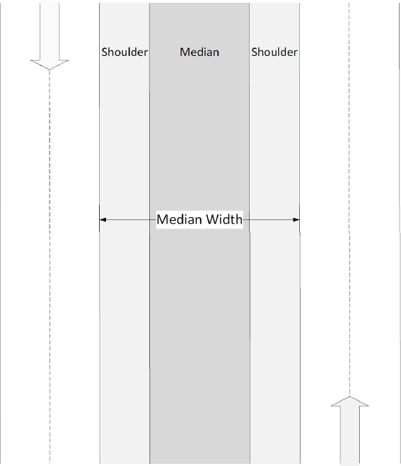
| ROADWAY TABLE | NUMBER OF LANES |
Number of Lanes in the Direction of Travel
| Screen Name: | Number of Lanes |
| Data Table: | Roadway |
| Variable: | NumLanes |
Element Attributes:
| Positive integers | Number of lanes in the direction of travel |
| -999 | Unknown |
Source:
Table 51. Populating the NCHRP 17-88 NumLanes Variable
| Source Database | Data Collection Type | Variable(s) Used | Notes |
|---|---|---|---|
| SHRP 2/RID | NA | - | NumLanes is not applicable. |
| NCHRP 17-43 | Researcher determined | - | Direct observation of available scaled scene diagram |
| IA Datasets | Derived from Source | NUMBER_LANES | |
| WA Datasets | Derived from Source | NO_LANE1, NO_LANE2, V1DIRCDE, V2DIRCDE | NO_LANE variables indicate number of lanes in increasing or decreasing milepost (MP) direction. DIRCDE variable indicates vehicle direction with respect to MPs. DIRCDE variables used to determine if NO_LANE1 or NO_LANE2 is used to populate NumLanes. |
| TN Datasets | Derived from Source | NUMBEROFTRAVELLANES, Divided (17-88) | Numberoftravellanes indicates number of lanes at the crash location; total lanes for undivided roadways and lanes in travel direction for divided roadways. Numberoftravellanes used directly for divided roads (Divided = 1). Numberoftravellanes is divided by 2 for undivided roads (Divided = 0). |
| MCCS | Researcher determined | NumLanes | NumLanes was used to determine the number of lanes at the crash site. All positive integers were coded for each lane as NumLanes > 0 and all unknowns were coded as NumLanes = -999. |
| NCHRP 22-26 | Researcher determined | - | Direct observation of available scaled scene diagram. |
| LTCCS | Researcher determined | - | Direct observation of available scaled scene diagram. |
Remarks:
This variable gives the number of lanes in the roadway in the direction of travel only.
- Acceleration and deceleration lanes should be counted as an additional lane if the lane is present at the point of departure or is traversed during the encroachment event.
- Two-way left turn lanes should be counted as a lane in the subject vehicle’s direction of travel.
| ROADWAY TABLE | TOTAL LANES |
Total Lanes
| Screen Name: | Total Lanes |
| Data Table: | Roadway |
| Variable: | TotalLanes |
Element Attributes:
| Positive integers | Total number of lanes in both directions of travel |
| -999 | Unknown |
Source:
Table 52. Populating the NCHRP 17-88 TotalLanes Variable
| Source Database | Data Collection Type | Variable(s) Used | Notes |
|---|---|---|---|
| SHRP 2/RID | Direct from Source | ThroughLanes_Total | Total number of through lanes for both directions |
| NCHRP 17-43 | Researcher determined | - | Direct observation of available scaled scene diagram |
| IA Datasets | Direct from Source | NUMBER_LANES | |
| WA Datasets | Direct from Source | NO_LANES | WA data includes only thru lanes in the total lane count. Acceleration, deceleration, or turn lanes are not counted. |
| TN Datasets | Direct from Source | NBR_LANES | |
| MCCS | Direct from Source | TotalLanes | The number of through lanes only are included in the count. |
| NCHRP 22-26 | Researcher determined | - | Direct observation of available scaled scene diagram. |
| LTCCS | Researcher determined | - | Direct observation of available scaled scene diagram. |
Remarks:
This variable gives the number of lanes in the roadway in both directions of travel. Turn lanes count toward the total number of lanes on the roadway.
| ROADWAY TABLE | LANE WIDTH |
Lane Width
| Screen Name: | Lane Width |
| Data Table: | Roadway |
| Variable: | LaneWidth |
Element Attributes:
| x > 0 | Lane width (meters) |
| -999 | Unknown |
Source:
Table 53. Populating the NCHRP 17-88 LaneWidth Variable
| Source Database | Data Collection Type | Variable(s) Used | Notes |
|---|---|---|---|
| SHRP 2/RID | Direct from Source | ThroughLanes1, ThroughLanes2 | ThroughLanes1 and ThroughLanes2 is the width of the lane for direction 1 and 2. |
| NCHRP 17-43 | Researcher Determined | - | Direct measurement of available scaled scene diagram |
| IA Datasets | Derived from Source | SURFACE_WIDTH, NUMBER_LANES | SURFACE_WIDTH for a roadway section is divided by NUMBER_LANES to compute lane width in feet. Values were then converted to meters. |
| WA Datasets | Derived from Source | LANEWID | WA lane width is computed by dividing roadway width by number of lanes. LANEWID is in feet; converted to meters for inclusion in 17-88. |
| TN Datasets | Derived from Source | TYP_FEAT, FEAT_WIDTH, and NBR_LANES | TN includes each lane as a separate feature. For each road segment, the width of all thru lanes (TYP_FEAT = 19) is summed and divided by total number of lanes (NBR_LANES) to compute an average lane width. This value is converted from feet to meters. |
| MCCS | Derived from Source | LaneWidth | LaneWidth is in feet; converted to meters for inclusion in 17-88. All positive integers were coded as LaneWidth > 0 and all unknowns as LaneWidth = -999. |
| NCHRP 22-26 | Researcher Determined | - | Direct observation of available scaled scene diagram. |
| LTCCS | Researcher Determined | - | Direct measurement of available scaled scene diagram. |
Remarks:
This variable encodes the width of the initial travel lane in meters. If there are no defined lanes, then LaneWidth should equal to half the width of the road, excluding the shoulder. If there is an additional lane, such as a parking or bike lane, that is not marked with a lane line, then the width of this additional lane is included in the lane width.
| ROADWAY TABLE | LANE MARKINGS |
Lane Markings: Left and Right
| Screen Name: | Lane Marking: Left Side, Lane Marking: Right Side |
| Data Table: | Roadway |
| Variable: | MarkingLeft, MarkingRight |
Element Attributes:
| 0 | None |
| 1 | Single-solid white |
| 2 | Single-solid yellow |
| 3 | Double-solid white |
| 4 | Double-solid yellow |
| 5 | Single-dashed (broken) white |
| 6 | Single-dashed (broken) yellow |
| 7 | Solid-dashed (broken) yellow (solid on the side of travel) |
| 8 | Solid-dashed (broken) yellow (dashed on the side of travel) |
| 9 | Bott’s dots |
| 88 | Other |
| -999 | Unknown |
Source:
Table 54. Populating the NCHRP 17-88 MarkingLeft and MarkingRight Variables
| Source Database | Data Collection Type | Variable(s) Used | Notes |
|---|---|---|---|
| SHRP 2/RID | NA | - | MarkingLeft, MarkingRight is not applicable. |
| NCHRP 17-43 | Researcher Determined | - | Determined using available crash scene diagram/crash narrative along with the available crash scene photographs. |
| IA Datasets | NA | - | Lane marking data not available from these sources. |
| WA Datasets | NA | - | |
| TN Datasets | Derived from Source | FEAT_CHAR, FEAT_LOC, NBR_LANES, and Divided (17-88) | Lane marking data available but initial lane of travel not reported. For two lane undivided roadways, presence (88) or absence (0) of lane markings are indicated. For all other roadway types, these variables are coded as unknown. |
| MCCS | Derived from Source / Researcher Determined | MarkingLeft, Marking Right | Recoded for inclusion in 17-88 and verified based on the scaled scene diagram. These variables were coded in as a |
| Source Database | Data Collection Type | Variable(s) Used | Notes |
|---|---|---|---|
| value from 0-88 based on the diagram. All unknowns were coded in as MarkingLeft or MarkingRight = -999. | |||
| NCHRP 22-26 | Researcher Determined | - | Determined using available crash scene diagram/crash narrative along with the available crash scene photographs. |
| LTCCS | Researcher Determined | - | Determined using available crash scene diagram/crash narrative along with the available crash scene photographs. |
Remarks:
This variable gives the lane markings on each side of the initial lane of travel. The left and right lane markings are recorded in separate variables. If the vehicle’s initial lane of travel is not known, then MarkingLeft = -999 and MarkingRight = -999.
| ROADWAY TABLE | HORIZONTAL ALIGNMENT |
Horizontal Alignment
| Screen Name: | Roadway Horizontal Alignment (qualitative) |
| Data Table: | Roadway |
| Variable: | Alignment |
Element Attributes:
| 1 | Curve left |
| 2 | Curve right |
| 3 | Tangent/Straight |
| -999 | Unknown |
Source:
Table 55. Populating the NCHRP 17-88 Alignment Variable
| Source Database | Data Collection Type | Variable(s) Used | Notes |
|---|---|---|---|
| SHRP 2/RID | NA | - | Alignment is not applicable. |
| NCHRP 17-43 | Direct from source/Researcher determined | ALIGNMNT | ALIGNMNT in NASS/CDS indicates the horizontal alignment of the road. This is verified by the scaled scene diagram and may be adjusted to represent the alignment at the point of departure. |
| IA Datasets | NA | - | This data not available from this source. All coded as unknown. |
| WA Datasets | Derived from Source | Crash file: V1DIRCDE, V2DIRCDE WA Curve File: BEGMP, ENDMP, DIR_CURV | RD_CHAR1 (crash file) includes qualitative descriptors of roadway horizontal alignment but variable not coded in more than half the cases so this was not used; WA curve file used instead. Event locations between BEGMP and ENDMP of any curve file entry were coded either 1 or 2. Direction determined using DIR_CURV variable in conjunction with DIRCDE variables (i.e., a left curve in the increasing MP direction would be a right curve in the decreasing MP direction). |
| TN Datasets | Direct from Source | ROADWAYCHARACTERALIG NMENT | Any missing values coded as “unknown” |
| Source Database | Data Collection Type | Variable(s) Used | Notes |
|---|---|---|---|
| MCCS | Derived from Source/Researcher determined | Alignment | The variable Alignment differentiates a road turn and a curve which were adapted for inclusion in 17-88. This is verified by the scaled scene diagram and may be adjusted to represent the alignment at the point of departure. Any missing values were coded as “unknown”. |
| NCHRP 22-26 | Researcher Determined | - | Determined using available crash scene diagram/crash narrative along with the available crash scene photographs. |
| LTCCS | Direct from source/Researcher determined | RoadAlignment | RoadAlignment in LTCCS indicates the horizontal alignment of the road. This is verified by the scaled scene diagram and may be adjusted to represent the alignment at the point of departure. |
Remarks:
This variable provides a qualitative description of the roadway horizontal alignment at the location of the road departure.
| ROADWAY TABLE | HORIZONTAL CURVE RADIUS |
Horizontal Curve Radius
| Screen Name: | Horizontal Curve Radius |
| Data Table: | Roadway |
| Variable: | Radius |
Element Attributes:
| (0, 100,000) | Horizontal curve radius (meters) |
| 100,000 | Tangent section (no horizontal curve) |
| -999 | Unknown |
Source:
Table 56. Populating the NCHRP 17-88 Radius Variable
| Source Database | Data Collection Type | Variable(s) Used | Notes |
|---|---|---|---|
| SHRP 2/RID | Direct from Source | Radius | The radius curve in feet, 0 is coded if tangent. |
| NCHRP 17-43 | Researcher determined | - | Direct measurement of available scaled scene diagram |
| IA Datasets | NA | - | This data is not available from this source. All values coded as unknown. |
| WA Datasets | Derived from Source | WA Curve File: CURV_RAD | For horizontally curved roadway sections, CURV_RAD reports radius in feet. Converted to meters for inclusion in 17-88. Same coding for reported and unreported crashes. |
| TN Datasets | Derived from Source | ETRIMS horizontal alignment data: Degree_of_Curve | For horizontally curved roadway sections, ETRIMS reports the degree of curvature. This was converted to a radius value in feet (R = 5729.58/Dc) prior to converting to meters. Same coding for reported and unreported crashes. |
| MCCS | Direct from Source | DepRadius | DepRadius reports all radii of horizontally curved roadway sections in feet and converts to meters for inclusion in 17-88. |
| NCHRP 22-26 | Researcher Determined | - | Direct measurement of available scaled scene diagram. |
| LTCCS | Derived from Source | AFTCurveRadius | LTCCS measures the radius of curvature of a road which was specified when the ‘Roadway Geometry (Curve)’ variable was coded as present. The radius was coded as AFTCurveRadius=* (actual value) in meters, Not |
| Source Database | Data Collection Type | Variable(s) Used | Notes |
|---|---|---|---|
| Applicable was coded as AFTCurveRadius= 8887.0, and Unknown was coded as AFTCurveRadius=9999. |
Remarks:
This variable gives the radius of curvature of the roadway in meters. For roads that are straight, the Radius is 100,000.
| ROADWAY TABLE | LAND DEVELOPMENT TYPE |
Land Development Type
| Screen Name: | Land Development Type |
| Data Table: | Roadway |
| Variable: | LandUse |
Element Attributes:
| 1 | Urban |
| 2 | Rural |
| 3 | Suburban |
| -999 | Unknown |
Source:
Table 57. Populating the NCHRP 17-88 LandUse Variable
| Source Database | Data Collection Type | Variable(s) Used | Notes |
|---|---|---|---|
| SHRP 2/RID | NA | - | LandUse is not applicable. |
| NCHRP 17-43 | Researcher determined | PSU | The NASS PSUs are sampled from urban, rural, and suburban regions. |
| IA Datasets | Derived from Source | urban_area_code | All road segment locations with an associated urban_area_code value are coded LandUse = 1. All missing values coded LandUse = 2. |
| WA Datasets | Direct from Source | RUR_URB, RURURB | For reported crashes, RUR_URB is used from the crash table. For unreported crashes, RURURB variable is used from the roadway table. WA only distinguishes between urban (including suburban) and rural. |
| TN Datasets | Derived from Source | FUNC_CLASS | For reported and unreported crashes, FUNC_CLASS is used to distinguish urban (codes 11 – 19) from rural (codes 1 – 9). |
| MCCS | Derived from Source | LandUse | LandUse was adjusted to distinguish urban (code 1) from rural (code 2) and suburban (code 3) regions. All unknowns were coded as LandUse = -999. |
| NCHRP 22-26 | Researcher Determined | - | Land Development type is determined from scene photographs and the scene diagram. |
| LTCCS | Researcher determined | - | Land Development type is determined from scene photographs and the scene diagram. |
Remarks:
This variable describes the general land development type in the area in which the event occurred. For the in-depth datasets, this is derived from the land development type of the sampling region (PSU), which is confirmed based on the scene photographs.
| ROADWAY TABLE | ROAD SURFACE CONDITION |
Level of Service
| Screen Name: | Road Level of Service (LOS) |
| Data Table: | Roadway |
| Variable: | ServiceQual |
Element Attributes:
| 1 | B |
| 2 | Be |
| 3 | C |
| 4 | Ce |
| 5 | D |
| 6 | De |
| 7 | <D |
| 8 | <De |
| 9 | E |
| 10 | Ee |
| 11 | F |
| 12 | Fe |
| -999 | Unknown |
Source:
Table 58. Populating the NCHRP 17-88 ServiceQual Variable
| Source Database | Data Collection Type | Variable(s) Used | Notes |
|---|---|---|---|
| SHRP 2/RID | NA | - | ServiceQual is not applicable. |
| NCHRP 17-43 | NA | - | LOS data not available from this source. All values coded as unknown. |
| IA Datasets | Derived from source | LOS data estimated based on available roadway/traffic data using procedures developed by Margiotta and Washburn (2017). Estimates correspond to peak hour traffic and exclude ramp sections and signalized roadway sections. | |
| WA Datasets | Derived from source | spd_limt, aadt, trkpcts, access, terrain, no_lanes, trf_cntl | |
| TN Datasets | Derived from source | Nbr_lanes, access_ctrl,aadt, vhcl_su_trk, vhcl_mu_trk | |
| MCCS | NA | - | LOS data not available from this source. All values coded as unknown. |
| NCHRP 22-26 | NA | - | LOS data not available from this source. All values coded as unknown. |
| LTCCS | NA | - | LOS data not available from this source. All values coded as unknown. |
Remarks:
This variable describes LOS for the roadway in the location of the documented event. LOS is a qualitative description of the operating conditions of the roadway at a specific time based primarily on traffic volume, proportion of large vehicles in the traffic stream, and number of travel lanes. Traffic congestion increases as LOS levels move from A to F. For a given roadway, the LOS may change throughout the day as traffic volume fluctuates.
The LOS data for the state datasets were estimated using available traffic/roadway characteristics data available and LOS lookup tables developed by Margiotta and Washburn (2017). The LOS lookup tables were derived from corresponding Highway Capacity Manual (HCM) procedures for determining motor vehicle LOS with varying assumptions intended to simplify the LOS determination procedure. Area type, posted speed limit, terrain, number of lanes, AADT, and truck percentage were used based on the available state roadway and traffic data. This information, along with roadway type, was used to estimate LOS for the peak hour traffic. Table 59 summarizes the required input data and resulting LOS threshold levels specified by roadway type.
Table 59. Roadway Types and Required Input Data
| Facility Type | Required Input Type | Categories | LOS Threshold Levels Specified |
|---|---|---|---|
| Freeway (controlled access) | Area Type | Urban, Rural | B, C, D, E |
| Number of Lanes | 4, 6, 8, 10, 12 | ||
| Truck Percentage | 0, 10, 20, 30 | ||
| Multilane Highways (unsignalized) | Area Type | Urban, Rural | B, C, D, E |
| Number of Lanes | 4, 6, 8, 10 | ||
| Truck Percentage | 0, 10, 20, 30 | ||
| Rural 2-Lane Highways | Speed Limit | 45, 50, 55, 60, 65 | B, C, D |
| Terrain | Flat, Rolling, Mountainous | ||
| Truck Percentage | 0, 2, 4, 6, 8, 10 |
Below are a few additional notes on the LOS estimates:
- For freeways and unsignalized multilane highways, LOS determination includes LOS B, C, D, E, and F. LOS F is estimated any time the freeway or multilane highway exceeds the associated traffic volume threshold for LOS E. As there is no threshold for LOS A, no LOS A values are reported.
- For rural two-lane highways, thresholds are only provided for LOS B, C, and D. Any segments exceeding the associated LOS D threshold traffic volume were labeled “< D” to indicate an LOS less than D (i.e., E or F), but the exact classification is not known.
- LOS was computed for unsignalized mainline sections only. No LOS was estimated for ramp or signalized sections.
- Only divided roadways with fully controlled access were classified as freeways. All others were considered multilane highways.
- For multilane highways, threshold values were linearly interpolated for sections containing a non-even number of lanes (e.g., five, seven, or nine lanes) within the available categories.
- Truck percentage categories were determined using the available state truck percentage data. The categories included the entire range of traffic volumes; for instance, the 10% truck category includes any non-zero truck percentage up to and including 10%.
- A number of the roadway sections had truck percentage values greater than the maximums listed in the table (e.g., 10% for rural two-lane highways and 30% for multilane highways and freeways). For these sections, the threshold values for the largest truck percentage were used, and the LOS value is denoted with an “e” to indicate that the truck percentage exceeded the available ranges in the lookup tables. We would expect these LOS estimates to be less reliable than those estimated for sections within the available truck percentage ranges.
| ROADWAY TABLE | VERTICAL GRADE |
Vertical Grade
| Screen Name: | Vertical Grade |
| Data Table: | Roadway |
| Variable: | RoadGrade |
Element Attributes:
| [-50, 50] | Roadway vertical grade (%) |
| -999 | Unknown |
Source:
Table 60. Populating the NCHRP 17-88 RoadGrade Variable
| Source Database | Data Collection Type | Variable(s) Used | Notes |
|---|---|---|---|
| SHRP 2/RID | Direct from source | Grade | Grade indicates grade direction (+/-) based on the direction of travel. Otherwise, all unknowns are coded as Grade = NA. |
| NCHRP 17-43 | Derived from Source | - | Road grade is coded when road grade is indicated on the scaled scene diagram. Otherwise, it is coded as unknown. |
| IA Datasets | NA | - | Roadway vertical grade not available from this source. |
| WA Datasets | Derived from Source | DIR_GRAD, PCT_GRAD, V1DIRCDE, V2DIRCDE | DIR_GRAD indicates grade direction (+/-) in the direction of increasing MP while PCT_GRAD indicates the grade magnitude. For reported crashes, DIR_GRAD and PCT_GRAD are combined based on the vehicle direction of travel (V1DIRCDE or V2DIRCDE). Unreported crashes coded based on the hardware location and nearest travel lane. |
| TN Datasets | Derived from Source | PCT_GRDE, PLUS_OR_MINUS, VEHICLEGOINGONDIRECTION | PLUS_OR_MINUS indicates grade direction (+/-) in the direction of increasing MP while PCT_GRDE indicates the grade magnitude. This data is combined based on the vehicle direction of travel. Unreported crashes coded based on the hardware location and nearest travel lane. |
| Source Database | Data Collection Type | Variable(s) Used | Notes |
|---|---|---|---|
| MCCS | Derived from Source | RoadGrade | RoadGrade indicates grade direction (+/-) based on the direction of travel. Otherwise, all unknowns are coded as RoadGrade = -999. |
| NCHRP 22-26 | Derived from Source | - | Road grade is coded when road grade is indicated on the scaled scene diagram. Otherwise, it is coded as unknown. |
| LTCCS | Derived from Source | - | Road grade is coded when road grade is indicated on the scaled scene diagram. Otherwise, it is coded as unknown. |
Remarks:
This variable gives the grade of the traveled way at the point of departure as a percentage. A positive and negative grade represent an uphill and downhill road, respectively. A definition of road grade is given in Figure 8:
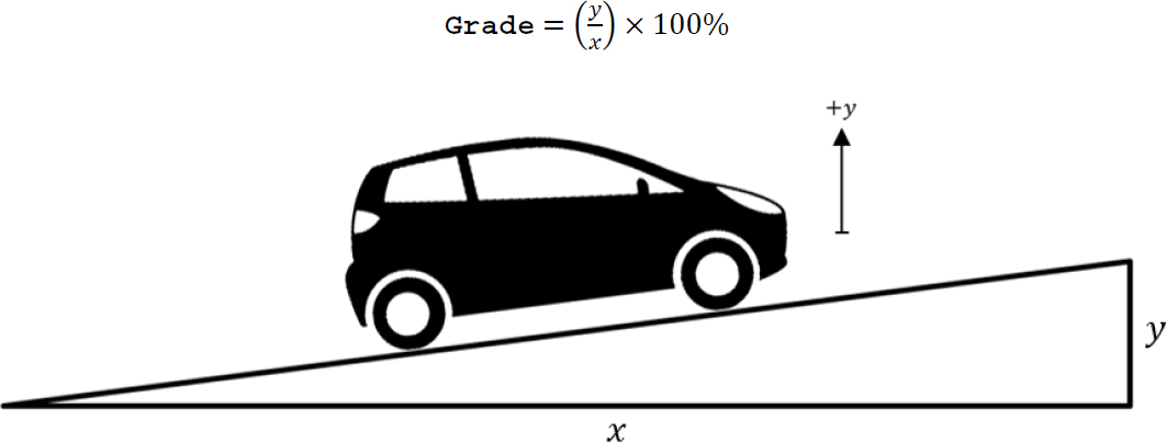
| ROADSIDE TABLE | TRAILER PRESENCE |
Vehicle Component Number
| Screen Name: | Vehicle Component Number |
| Data Table: | Roadside |
| Variable: | Component |
Element Attributes:
| 0 | Cab / Motorcycle |
| 1, 2, 3, … | Trailer number / Ride number |
| -998 | Not applicable |
| -999 | Unknown |
Source:
Table 61. Populating the NCHRP 17-88 Component Variable
| Source Database | Data Collection Type | Variable(s) Used | Notes |
|---|---|---|---|
| SHRP 2/RID | NA | - | Component is not applicable. |
| NCHRP 17-43 | Researcher Determined | - | Determined using the available crash scene diagram. |
| IA Datasets | NA | - | Detailed scene diagrams not available for state data sources to discern vehicle trajectory information or vehicle component trajectory information. |
| WA Datasets | NA | - | |
| TN Datasets | NA | - | |
| MCCS | Researcher Determined | Component | Determined using the available crash scene diagram. |
| NCHRP 22-26 | Researcher Determined | - | Determined using the available crash scene diagram and crash summary. |
| LTCCS | Researcher Determined | - | Determined using the available crash scene diagram. |
Remarks:
This variable differentiates between the cab and trailer(s) for vehicles and large trucks.
- If the vehicle is not towing a trailer, then Component = -998.
- The trailer nearest to the cab should be specified as Component = 1. Any subsequent trailers should be counted in series from the first trailer.
This variable differentiates between the motorcycle and rider(s) for motorcycle impacts.
- The driver of the motorcycle, if specified, should be specified as Component = 1. Any other riders should be counted in series.
| ROADSIDE TABLE | DEPARTURE NUMBER |
Departure Number
| Screen Name: | Departure Number |
| Data Table: | Roadside |
| Variable: | NumDepart |
Element Attributes:
| Positive integers | Departure number |
| -999 | Unknown |
Source:
Table 62. Populating the NCHRP 17-88 NumDepart Variable
| Source Database | Data Collection Type | Variable(s) Used | Notes |
|---|---|---|---|
| SHRP 2/RID | Direct from Source | - | All crashes have only one departure. |
| NCHRP 17-43 | Researcher Determined | - | Determined using the available crash scene diagram. |
| IA Datasets | Derived from Source | SEQEVENTS1 - 4 | For single and multiple-vehicle reported crashes, the four event variables are used to tally the number of departures (instances of ran off road right, ran off road left and cross median are summed). For cases where there is no run off road coded but a roadside object is struck, NumDepart is coded as 1. Available data not able to discern partial departures. NumDepart coded as unknown for unreported crashes. |
| WA Datasets | Derived from Source | EVENT1 - 4 | For single and multiple-vehicle reported crashes, the four event variables are used to tally the number of departures (instances of ran off the road are summed for each vehicle). For cases where there is no run off road coded but a roadside object is struck, NumDepart is coded as 1. Available data not able to discern partial departures. NumDepart coded as unknown for unreported crashes. |
| TN Datasets | Derived from Source | EVENT_SEQ1 - 10 | For single-vehicle reported crashes, the event sequence data is used to tally the number of departures (instances of ran off road right, ran off road left and cross median are summed). For cases where there is no run off road coded but a roadside object is struck, NumDepart is coded as 1. Multiple-vehicle reported crashes do not contain vehicle level event sequence data. Available data not |
| Source Database | Data Collection Type | Variable(s) Used | Notes |
|---|---|---|---|
| able to discern partial departures. NumDepart coded as unknown for multiple-vehicle crashes and unreported crashes. | |||
| MCCS | Researcher Determined | NumDepart | Determined using the available crash scene diagram. All positive integers are coded to tally the number of departures. For cases where there is no run off road coded but a roadside object is struck, NumDepart is coded as 1. All unknowns are coded as NumDepart = -999. |
| NCHRP 22-26 | Researcher Determined | - | Determined using the available crash scene diagram. |
| LTCCS | Researcher Determined | - | Determined using the available crash scene diagram. |
Remarks:
This variable encodes an integer that counts how many departures have occurred; when multiple departures occur, the count is tallied here. If a partial departure occurs, NumDepart should still be increased by one. Detailed information on the definition of each type of departure is included under the DepartType variable in the following section.
| ROADSIDE TABLE | DEPARTURE SIDE |
Departure Type
| Screen Name: | Departure Type |
| Data Table: | Roadside |
| Variable: | DepartType |
Element Attributes:
| 1 | Departure |
| 2 | Reentry |
| 3 | Partial departure |
| -999 | Unknown |
Source:
Table 63. Populating the NCHRP 17-88 DepartType Variable
| Source Database | Data Collection Type | Variable(s) Used | Notes |
|---|---|---|---|
| SHRP 2/RID | Derived from Source | ||
| NCHRP 17-43 | Researcher Determined | - | Determined using the available crash scene diagram and written crash summary. |
| IA Datasets | NA | - | Scene diagrams not available from the state data sources. |
| WA Datasets | NA | - | |
| TN Datasets | NA | - | |
| MCCS | Researcher Determined | DepartType | DepartType is used to differentiate each vehicle’s departure type. All unknowns are coded as DepartType = -999. |
| NCHRP 22-26 | Researcher Determined | - | Determined using the available crash scene diagram. |
| LTCCS | Researcher Determined | - | Determined using the available crash scene diagram and written crash summary. |
Remarks:
This variable encodes the type of crossing by the encroaching vehicle. A more detailed description of each departure type is shown below:
- A departure occurs when the center of gravity (CG) of the vehicle crosses the edge of the traveled way onto the roadside. If a vehicle departs the traveled way and enters the median on a divided roadway, this will be considered a point of departure if one of the conditions is satisfied:
- The vehicle strikes an object in the median.
- The vehicle’s final resting position is in the median.
- A re-entry occurs when the CG of the vehicle crosses over the edge of the traveled way from the roadside.
- A partial departure occurs when any plane of the vehicle crosses over the edge of the traveled way, but the CG does not.**
**Specific information on where to place the origin during a partial departure is shown below:
Scenario A: A vehicle hits an object and comes to rest while in contact with the object during a partial departure (the vehicle CG never crosses the edge of the road). In this case, the origin will be placed on the edge of the roadway, laterally from the CG of the vehicle at the point of impact. The y-axis of the origin should be tangent to the road and the coordinates of the CG during the partial departure should be (±x, 0).

Scenario B: A vehicle hits an object during a partial departure but continues to make a full departure. After the full departure, the vehicle may or may not strike additional objects. In this case, the origin will be placed on the edge of the roadway, laterally from the CG of the vehicle at the point of impact. The y-axis of the origin should be tangent to the road and the coordinates of the CG during the partial departure should be (±x, 0).
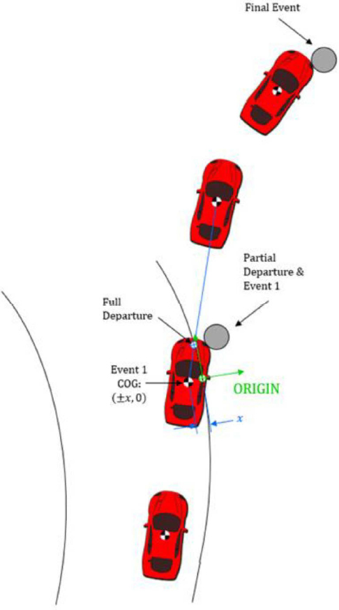
Scenario C: A vehicle partially departs the roadway, does not impact anything, then reenters the traveled way. The vehicle later fully departs the roadway and impacts an object. In this case, the origin will be the point where the vehicle fully departs the road.
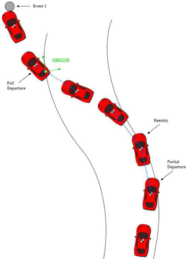
| ROADSIDE TABLE | CROSS MEDIAN DEPARTURE |
Departure Side
| Screen Name: | Departure Side |
| Data Table: | Roadside |
| Variable: | Side |
Element Attributes:
| 1 | Left |
| 2 | Right |
| 3 | End Departure |
| -999 | Unknown |
Source:
Table 64. Populating the NCHRP 17-88 Side Variable
| Source Database | Data Collection Type | Variable(s) Used | Notes |
|---|---|---|---|
| SHRP 2/RID | Direct from Source | - | |
| NCHRP 17-43 | Researcher Determined | - | Determined using the available crash scene diagram and written crash summary. |
| IA Datasets | Derived from Source | SEQEVENTS1 - 4 | For single and multiple-vehicle reported crashes, the event variable(s) noting that a vehicle left the road are used to determine departure side (ran off road right, ran off road left or ran off road straight). Unreported crashes coded as unknown. |
| WA Datasets | Derived from Source | IMPACT, V1DIRCDE | For single-vehicle crashes, the IMPACT variable notes the crash location in detail and the V1DIRCDE indicates the travel direction of the vehicle. Both of these are used to determine the departure side. Since IMPACT is a crash level variable, it cannot be used for multiple-vehicle crashes. Multiple-vehicle crashes and unreported crashes are coded as unknown. |
| TN Datasets | Derived from Source | EVENT_SEQ1 - 10 | For single-vehicle reported crashes, the event sequence(s) involving run off road are used to determine departure side (ran off road right, ran off road left). Multiple-vehicle reported crashes do not contain vehicle level event sequence data. Multiple-vehicle crashes and |
| Source Database | Data Collection Type | Variable(s) Used | Notes |
|---|---|---|---|
| unreported crashes are coded as unknown. | |||
| MCCS | Researcher Determined | Side | The Side variable is used to note that a vehicle left the road and to determine departure side (ran off road right, ran off road left or ran off road straight). Unreported crashes are coded as unknown. |
| NCHRP 22-26 | Researcher Determined | - | Determined using the available crash scene diagram. |
| LTCCS | Researcher Determined | - | Determined using the available crash scene diagram and written crash summary. |
Remarks:
For roads divided by median, the left roadside is the side of the road adjacent to the median in the direction of travel of the vehicle.
| ROADSIDE TABLE | DEPARTURE TYPE |
Cross-Median Departure
| Screen Name: | Cross-Median Departure |
| Data Table: | Roadside |
| Variable: | CrossMedian |
Element Attributes:
| 0 | Not a cross-median departure |
| 1 | Cross-median departure |
| -999 | Unknown |
Source:
Table 65. Populating the NCHRP 17-88 CrossMedian Variable
| Source Database | Data Collection Type | Variable(s) Used | Notes |
|---|---|---|---|
| SHRP 2/RID | NA | - | CrossMedian is not applicable. |
| NCHRP 17-43 | Researcher Determined | - | Determined using the available crash scene diagram and written crash summary. |
| IA Datasets | Derived from Source | SEQEVENTS1 - 4 | For included single and multiple-vehicle crashes, coded as 1 if one or more SEQEVENTS variables is coded as cross median or cross centerline. Unreported crashes are coded as unknown. |
| WA Datasets | Derived from Source | IMPACT, EVENT1-4, V1DIRCDE, V2DIRCDE | For single-vehicle crashes, V1DIRCDE and IMPACT are used to determine if the vehicle crossed a centerline/median prior to the crash event. For multiple-vehicle crashes, vehicles that departed the roadway (indicated by the EVENT variables) and collided with a vehicle traveling in the opposite direction (V1DIRCDE and V2DIRCDE are in opposing directions) are coded as 1. Cross median events without a crash cannot be identified. Unreported crashes are coded as unknown. |
| TN Datasets | Derived from Source | EVENT_SEQ1 - 10 | For included single-vehicle crashes, coded as 1 if one or more EVENT_SEQ variables is coded as cross median or cross centerline. No multiple-vehicle crashes included. Unreported crashes are coded as unknown. |
| MCCS | Researcher Determined | CrossMedian | CrossMedian is coded to determine whether the vehicle crossed a |
| Source Database | Data Collection Type | Variable(s) Used | Notes |
|---|---|---|---|
| centerline/median prior to the crash. Unreported crashes are coded as unknown. | |||
| NCHRP 22-26 | Researcher Determined | - | Determined using the available crash scene diagram. |
| LTCCS | Researcher Determined | - | Determined using the available crash scene diagram and written crash summary. |
Remarks:
This variable encodes whether the vehicle completely crossed a median during that departure. For NCHRP 17-43, LTCCS, and MCCS, this only includes medians on divided roadways. Encroachments crossing a centerline would be coded as “Not a cross-median departure.”
For this study, two-way left-turn lane (TWLTL) are not considered medians and are counted as lanes in the direction of travel, which would be coded as “Not a cross-median departure.”

| ROADSIDE TABLE | ROADSIDE CROSS SECTION |
Roadside Cross Section
| Screen Name: | Roadside Cross Section |
| Data Table: | Roadside |
| Variable: | XSection |
Element Attributes:
| 1 | Level |
| 2 | Uniform foreslope |
| 3 | Multiple foreslopes |
| 4 | Foreslope, no bottom width, and a backslope |
| 5 | Foreslope, a bottom width, and a backslope |
| 6 | Multiple foreslopes, no bottom width, and a backslope |
| 7 | Multiple foreslopes, no bottom width, and a backslope |
| 8 | Wall/barrier |
| 9 | Backslope |
| 10 | Curb |
| 88 | Other |
| -999 | Unknown |
Source:
Table 66. Populating the NCHRP 17-88 XSection Variable
| Source Database | Data Collection Type | Variable(s) Used | Notes |
|---|---|---|---|
| SHRP 2/RID | NA | - | XSection is not applicable. |
| NCHRP 17-43 | Researcher Determined | - | Determined using the available crash scene photographs and crash scene diagrams. |
| IA Datasets | NA | - | Roadside configuration data not collected for these datasets. |
| WA Datasets | NA | ||
| TN Datasets | NA | ||
| MCCS | Researcher Determined | XSection | Determined using the available crash scene photographs and crash scene diagrams. All unknowns are coded as -999. |
| NCHRP 22-26 | NA | - | NCHRP 22-26 does not include scene photographs to determine the cross-section shape. |
| LTCCS | Researcher Determined | - | Determined using the available crash scene photographs and crash scene diagrams. |
Remarks:
This variable specifies the roadside cross-section at the point of departure; see Figure 13 for variable description diagrams. When assessing the roadside cross-section, concrete barriers and curbs are included as part of the roadside, but guardrails are not.

| ROADSIDE TABLE | ADDITIONAL LANE TYPE |
Additional Lane Type
| Screen Name: | Additional Lane Type |
| Data Table: | Roadside |
| Variable: | AdditionalLane |
Element Attributes:
| 0 | None |
| 1 | Parking Lane |
| 2 | Bike Lane |
| 3 | Both |
| -999 | Unknown |
Source:
Table 67. Populating the NCHRP 17-88 AdditionalLane Variable
| Source Database | Data Collection Type | Variable(s) Used | Notes |
|---|---|---|---|
| SHRP 2/RID | NA | - | AdditionalLane is not applicable. |
| NCHRP 17-43 | Researcher Determined | - | Determined using the available crash scene diagram and crash scene photographs. |
| IA Datasets | Derived from Source | PARKING_TYPE, SEQEVENTS1 - 4 | For reported crashes, parking location is determined using PARKING_TYPE and departure side is determined based on the SEQEVENTS variables. For unreported crashes, parking presence is based on the location of the struck hardware. Bike lane presence data not available. |
| WA Datasets | Derived from Source | PRK_ZNE, IMPACT | For single-vehicle crashes, PRK_ZNE variable is used to determine parking lane presence for left, right, or both sides of the road while IMPACT is used to determine the specific location of the crash. Multiple-vehicle crashes coded as unknown unless parking present on both sides (as departure side not discernable for multiple-vehicle crashes). For unreported crashes, parking presence is based on the location of the struck hardware. Bike lane presence data not available. |
| TN Datasets | Derived from Source | EVENT_SEQ1 – 10, TYP_FEAT, FEAT_LOC | For single-vehicle reported crashes, the event sequence(s) involving run off road are used to determine departure side (ran off road right, |
| Source Database | Data Collection Type | Variable(s) Used | Notes |
|---|---|---|---|
| ran off road left). TYP_FEAT = parking lane and FEAT_LOC (left or right) is used to determine parking lane presence. Multiple-vehicle reported crashes do not contain vehicle level event sequence data. For unreported crashes, parking presence is based on the location of the struck hardware. | |||
| MCCS | Researcher Determined | AdditionalLane | AdditionalLane is used to specify lane presence for left, right, or both sides of the road. For unreported crashes, parking presence is based on the location of the struck hardware. All unknowns are coded as -999. |
| NCHRP 22-26 | Researcher Determined | - | Determined using the available crash scene diagram and crash scene photographs. |
| LTCCS | Researcher Determined | - | Determined using the available crash scene diagram and crash scene photographs. |
Remarks:
This variable specifies if a parking lane was present where the event occurred. If a bike or parking lane is present, this additional lane width is incorporated in other variables depending on the lane markings. If there is no lane marking separating the additional lane, then the width is included with the “lane width” variable. If there is a lane marking, then the additional lane width is included in the shoulder width measurement.
| ROADSIDE TABLE | ROAD SHOULDER TYPE |
Shoulder Type
| Screen Name: | Road Shoulder Type |
| Data Table: | Roadside |
| Variable: | ShoulderType |
Element Attributes:
| 0 | None |
| 1 | Asphalt (AC) |
| 2 | Concrete |
| 3 | Stabilized |
| 4 | Combination |
| 5 | Earth (soil/grass) |
| -999 | Unknown |
Source:
Table 68. Populating the NCHRP 17-88 ShoulderType Variable
| Source Database | Data Collection Type | Variable(s) Used | Notes |
|---|---|---|---|
| SHRP 2/RID | Direct from Source | ShoulderTypeID | The ShoulderTypeID variable is used to determine the type of shoulder. It is coded as Unknown = -1, Curb = 1, Mix/Combo = 2, Paved = 3, Gravel = 4, and Dirt = 5 |
| NCHRP 17-43 | Researcher Determined | - | Determined using the available crash scene photographs. |
| IA Datasets | Derived from Source | RIGHT_SHOULDER_TYPE, RIGHT_SHOULDER_WIDTH, LEFT_SHOULDER_TYPE, LEFT_SHOULDER_WIDTH, SEQEVENTS1 - 4 | For reported crashes, departure side is determined based on the SEQEVENTS variables. Shoulder type and width variables are used to determine shoulder type for non-zero width shoulders based on departure side. For unreported crashes, shoulder type is based on the location of the struck hardware. |
| WA Datasets | Derived from Source | RSHL_TYP, RSHL_TY2, RSHLDWID, RSHL_WD2, LSHL_TYP, LSHL_TY2, LSHLWID, LSHL_WD2 IMPACT, V1DIRCDE | For single-vehicle crashes, the IMPACT variable notes crash location in detail and the V1DIRCDE indicates the travel direction of the vehicle. Both of these are used to determine the departure side. Shoulder type and width variables are used to determine shoulder type for nonzero width shoulders based on |
| Source Database | Data Collection Type | Variable(s) Used | Notes |
|---|---|---|---|
| WA Datasets | departure side. Shoulder variables ending in 2 are for the decreasing MP side and left shoulders are only present on divided roadways. For unreported crashes, shoulder type is based on the location of the struck hardware. Multiple-vehicle crashes are coded as unknown. | ||
| TN Datasets | Derived from Source | RT_SHOULD_TYP, RT_SHOULD_WDTH, LT_SHOULD_TYP, LT_SHOULD_WDTH, EVENT_SEQ1 – 10 | For single-vehicle crashes, event sequence variables are used to determine departure side. Shoulder type and width variables are used to determine shoulder type for non-zero width shoulders. Any bituminous surface is coded as ShoulderType = 1. For unreported crashes, shoulder type is based on the location of the struck hardware. All shoulders with width = 0 are coded as ShoulderType = 0. |
| MCCS | Researcher Determined | ShoulderType | The ShoulderType variable is used to determine the shoulder type for non-zero width shoulders based on departure side. All shoulders with zero widths are coded as ShoulderType = 0. All unknowns are coded as ShoulderType = -999. |
| NCHRP 22-26 | Researcher Determined | - | Determined using the available crash scene photographs. |
| LTCCS | Researcher Determined | - | Determined using the available crash scene photographs. |
Remarks:
This variable describes the roadside shoulder surface at the point of departure.
| ROADSIDE TABLE | SHOULDER WIDTH |
Shoulder Width
| Screen Name: | Shoulder Width |
| Data Table: | Roadside |
| Variable: | ShoulderWidth |
Element Attributes:
| 0 | No shoulder |
| x > 0 | Shoulder width (meters) |
| -999 | Unknown |
Source:
Table 69. Populating the NCHRP 17-88 ShoulderWidth Variable
| Source Database | Data Collection Type | Variable(s) Used | Notes |
|---|---|---|---|
| SHRP 2/RID | Direct from Source | Width | Width (in feet) of the Paved Section of the Shoulder. |
| NCHRP 17-43 | Researcher Determined | - | Determined using the available scaled crash scene diagram. |
| IA Datasets | Derived from Source | RIGHT_SHOULDER_WIDTH, LEFT_SHOULDER_WIDTH, SEQEVENTS1 - 4 | For reported crashes, the departure side is determined based on the SEQEVENTS variables. Shoulder width reported based on departure side. For unreported crashes, shoulder width is based on the location of the struck hardware. Width values converted from feet to meters. |
| WA Datasets | Derived from Source | RSHLDWID, RSHL_WD2, LSHLWID, LSHL_WD2 IMPACT, V1DIRCDE | For single-vehicle crashes, the IMPACT variable notes crash location in detail and the V1DIRCDE indicates the travel direction of the vehicle. Both of these are used to determine the departure side. Shoulder width reported based on departure side. Shoulder variables ending in 2 are for the decreasing MP side and left shoulders are only present on divided roadways. For unreported crashes, shoulder width is based on the location of the struck hardware. Multiple-vehicle crashes are coded as unknown. Width values converted from feet to meters. |
| Source Database | Data Collection Type | Variable(s) Used | Notes |
|---|---|---|---|
| TN Datasets | Derived from Source | RT_SHOULD_WDTH, LT_SHOULD_WDTH, EVENT_SEQ1 – 10 | For single-vehicle crashes, event sequence variables are used to determine departure side. Shoulder width reported based on departure side. For unreported crashes, shoulder width is based on the location of the struck hardware. Width values converted from feet to meters. |
| MCCS | Researcher Determined | ShoulderWidth | The ShoulderWidth variable is used to determine the shoulder width for non-zero width shoulders based on departure side. Crashes with no shoulder present are coded as ShoulderWidth = 0. All unknowns are coded as ShoulderWidth = -999. |
| NCHRP 22-26 | Researcher Determined | - | Determined using the available scaled crash scene diagram. |
| LTCCS | Researcher Determined | - | Determined using the available scaled crash scene diagram. |
Remarks:
This variable gives the width of the roadside shoulder in meters. The shoulder width should be measured at the point of departure. For roads divided with a median, the left shoulder width is the distance between the edge of the left-most lane in the direction of travel and the right median edge. If there is an additional lane, such as a parking or bike lane, that is marked with a lane line, then the width of this additional lane is included in the shoulder width.

| ROADSIDE TABLE | CURB PRESENCE/HEIGHT |
Curb Presence/Height
| Screen Name: | Curb Presence/Height |
| Data Table: | Roadside |
| Variable: | Curb |
Element Attributes:
| 0 | No Curb |
| 1 | Curb with height < 6 in |
| 2 | Curb with height ≥ 6 in |
| 3 | Curb with unknown height |
| -999 | Unknown |
Source:
Table 70. Populating the NCHRP 17-88 Curb Variable
| Source Database | Data Collection Type | Variable(s) Used | Notes |
|---|---|---|---|
| SHRP 2/RID | NA | - | Curb is not applicable. |
| NCHRP 17-43 | Researcher Determined | - | Estimated using the available crash scene photographs by the researcher. |
| IA Datasets | Derived from Source | LEFT_SHOULDER_CURBED, RIGHT_SHOULDER_CURBED, SEQEVENTS1 - 4 | For reported crashes, departure side is determined based on the SEQEVENTS variables. Curb presence (0 or 3) reported based on departure side. For unreported crashes, curb presence is based on the location of the struck hardware. |
| WA Datasets | Derived from Source | RSHL_TYP, RSHL_TY2, LSHL_TYP, LSHL_TY2, IMPACT, V1DIRCDE | For single-vehicle crashes, the IMPACT variable notes crash location in detail and the V1DIRCDE indicates the travel direction of the vehicle. Both of these are used to determine the departure side. Shoulder type variables have a curbed option. If curbed is noted for the departure side, coded as 3; otherwise coded 0. Shoulder variables ending in 2 are for the decreasing MP side and left shoulders are only present on divided roadways. For unreported crashes, curb presence is based on the location of the struck |
| Source Database | Data Collection Type | Variable(s) Used | Notes |
|---|---|---|---|
| hardware. Multiple-vehicle crashes are coded as unknown. | |||
| TN Datasets | Derived from Source | RT_DRAINAGE_TYP, LT_DRAINAGE_TYP, EVENT_SEQ1 – 10 | For single-vehicle crashes, event sequence variables are used to determine departure side. Curb presence (0 or 3) determined based on departure side and drainage type variable. Curb only, curb and gutter, curb/gutter/sidewalk, and curb/sidewalk are all considered curb present. For unreported crashes, curb presence is based on the location of the struck hardware. |
| MCCS | NA | CurbType | CurbType determines curb presence (0 or 3) reported based on departure side and curb height. All unknowns are coded as CurbType = -999. |
| NCHRP 22-26 | Researcher Determined | - | Estimated using the available crash scene photographs by the researcher. |
| LTCCS | Researcher Determined | - | Estimated using the available crash scene photographs by the researcher. |
Remarks:
This variable specifies if a curb was present at the point of departure and whether it had a height more than 6 in.
| ROADSIDE TABLE | ROAD CLEARANCE |
Clear Width to Roadside Objects
| Screen Name: | Clear Width to Roadside Objects |
| Data Table: | Roadside |
| Variable: | ClearWidth |
Element Attributes:
| x ≥ 0 | Roadside clear width (meters) |
| -999 | Unknown |
Source:
Table 71. Populating the NCHRP 17-88 ClearWidth Variable
| Source Database | Data Collection Type | Variable(s) Used | Notes |
|---|---|---|---|
| SHRP 2/RID | NA | - | ClearWidth is not applicable. |
| NCHRP 17-43 | Researcher Determined | - | Determined using the available crash scene diagram. Note: not all roadside objects are captured on the scene diagram. |
| IA Datasets | NA | Clear width was not collected for the state data. | |
| WA Datasets | NA | ||
| TN Datasets | NA | ||
| MCCS | Researcher Determined | ClearWidth | The ClearWidth variable is used to determine the distance from the edge of travel to the closest roadside object. All unknowns are coded as ClearWidth = -999. |
| NCHRP 22-26 | Researcher Determined | - | Determined using the available crash scene diagram. Note: not all roadside objects are captured on the scene diagram. |
| LTCCS | Researcher Determined | - | Determined using the available crash scene diagram. Note: not all roadside objects are captured on the scene diagram. |
Remarks:
This variable encodes the lateral distance from the edge of the traveled way to the nearest roadside object in meters. It should be noted that ClearWidth is not always the distance to the object struck. If a vehicle departs from multiple sides of the road, clear width must be measured for each side, as shown in Figure 15. :
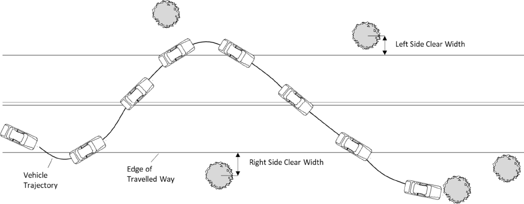
| ROADSIDE TABLE | LANE MARKING: POINT OF DEPARTURE |
Point of Departure Lane Marking
| Screen Name: | Lane Marking: Point of Departure |
| Data Table: | Roadside |
| Variable: | MarkingPOD |
Element Attributes:
| 0 | None |
| 1 | Single-solid white |
| 2 | Single-solid yellow |
| 3 | Double-solid white |
| 4 | Double-solid yellow |
| 5 | Single-dashed (broken) white |
| 6 | Single-dashed (broken) yellow |
| 7 | Solid-dashed (broken) yellow (solid on the side of travel) |
| 8 | Solid-dashed (broken) yellow (dashed on the side of travel) |
| 9 | Bott’s dots |
| 88 | Other |
| -999 | Unknown |
Source:
Table 72. Populating the NCHRP 17-88 MarkingPOD Variable
| Source Database | Data Collection Type | Variable(s) Used | Notes |
|---|---|---|---|
| SHRP 2/RID | NA | - | MarkingPOD is not applicable. |
| NCHRP 17-43 | Researcher Determined | - | Determined using the available crash scene diagram and crash scene photographs. |
| IA Datasets | NA | - | Lane marking data not available from these sources. |
| WA Datasets | NA | - | |
| TN Datasets | Derived from Source | FEAT_CHAR, FEAT_LOC, NBR_LANES, and Divided (17-88) | Lane marking data available but initial lane of travel not reported. For two lane undivided roadways, presence (88) or absence (0) of lane markings are indicated. For all other roadway types, these variables are coded as unknown. |
| MCCS | Researcher Determined | MarkingPOD | The MarkingPOD variable determines the type of lane marking at the point of departure. If there is no marking present, then it is coded as MarkingPOD = 0. All unknowns are coded as MarkingPOD = -999. |
| NCHRP 22-26 | Researcher Determined | - | Determined using the available crash scene diagram and crash scene photographs. |
| Source Database | Data Collection Type | Variable(s) Used | Notes |
|---|---|---|---|
| LTCCS | Researcher Determined | - | Determined using the available crash scene diagram and crash scene photographs. |
Remarks:
This variable gives the lane markings at the point of departure. If the vehicle’s initial lane of travel is not known, then MarkingPOD = -999.
| ROADSIDE TABLE | ROADSIDE SURFACE CONDITION |
Roadside Soil Condition
| Screen Name: | Roadside Surface Condition |
| Data Table: | Roadside |
| Variable: | RoadsideCondition |
Element Attributes:
| 1 | Normal |
| 2 | Muddy/waterlogged |
| 3 | Frozen |
| 4 | Snow |
| -999 | Unknown |
Source:
Table 73. Populating the NCHRP 17-88 RoadsideCondition Variable
| Source Database | Data Collection Type | Variable(s) Used | Notes |
|---|---|---|---|
| SHRP 2/RID | NA | - | RoadsideCondition is not applicable. |
| NCHRP 17-43 | Researcher Determined | - | Determined using the available crash scene photographs. |
| IA Datasets | NA | - | Roadside surface condition data not available from the state data sources. |
| WA Datasets | NA | - | |
| TN Datasets | NA | - | |
| MCCS | NA | - | Scene photographs are not available in MCCS to determine the roadside surface condition. |
| NCHRP 22-26 | Researcher Determined | - | Determined using the available crash scene photographs. |
| LTCCS | Researcher Determined | - | Determined using the available crash scene photographs. |
Remarks:
This variable describes the condition of the roadside surface. This may differ from the condition of the roadway; for example, the roadside may be covered in snow, but the roadway may be plowed and have normal conditions. The roadside surface condition could be different in the scene photographs from when the encroachment occurred.
| ROADSIDE TABLE | RUMBLE STRIP PRESENCE |
Rumble Strip Presence
| Screen Name: | Rumble Strip Presence |
| Data Table: | Roadside |
| Variable: | Rumble |
Element Attributes:
| 0 | No |
| 1 | Yes |
| -999 | Unknown |
Source:
Table 74. Populating the NCHRP 17-88 Rumble Variable
| Source Database | Data Collection Type | Variable(s) Used | Notes |
|---|---|---|---|
| SHRP 2/RID | Direct from Source | Rumble | The Rumble variable is used to determine departure side based on the presence of a rumble strip. If present, it is coded = Ture. If not, it is coded as Rumble = False. |
| NCHRP 17-43 | NA | - | This data not available from this source. |
| IA Datasets | Derived from Source | LEFT_SHOULDER_RUMBLE, RIGHT_SHOULDER_RUMBLE, SEQEVENTS1 - 4 | For reported crashes, departure side is determined based on the SEQEVENTS variables. Rumble presence reported based on departure side. For unreported crashes, rumble presence is based on the location of the struck hardware. |
| WA Datasets | Derived from Source | A separate dataset of rumble strip locations was provided by WA state. This file was used to determine rumble strip presence. | |
| TN Datasets | Derived from Source | FEAT_CHAR, EVENT_SEQ1 – 10 | For single-vehicle crashes, event sequence variables are used to determine departure side. FEAT_CHAR used to determine rumble strip presence (rumble w/stripe or rumble w/o stripe coded as yes). For unreported crashes, rumble presence is based on the location of the struck hardware. |
| MCCS | Derived from Source | Rumble | The Rumble variable is used to determine departure side based on the presence of a rumble strip. If present, it has a value of 1. If not, it is coded as Rumble = 0. All |
| Source Database | Data Collection Type | Variable(s) Used | Notes |
|---|---|---|---|
| unknowns are coded as Rumble = -999. | |||
| NCHRP 22-26 | Researcher Determined | - | Determined using the available crash scene photographs. |
| LTCCS | Derived from Source | RumbleStrip | LTCCS indicates whether or not a rumble strip is present, the type of rumble strip, and the involvement of the rumble strip with the vehicle. |
Remarks:
This variable specifies if a rumble strip was present on the roadway edge where the departure occurred.
| ROADSIDE TABLE | VEHICLE DEPARTURE SPEED |
Vehicle Departure Speed
| Screen Name: | Vehicle Departure Speed |
| Data Table: | Roadside |
| Variable: | DepSpeed |
Element Attributes:
| x > 0 | Departure speed (kph) |
| -999 | Unknown |
Source:
Table 75. Populating the NCHRP 17-88 DepSpeed Variable
| Source Database | Data Collection Type | Variable(s) Used | Notes |
|---|---|---|---|
| SHRP 2/RID | NA | - | DepSpeed is not applicable. |
| NCHRP 17-43 | Researcher Determined | - | The 17-43 research team reconstructed the departure speed based on the distance traveled prior to the impact and the impact speed. |
| IA Datasets | NA | - | Detailed vehicle departure speed information not available from state data sources. |
| WA Datasets | NA | - | |
| TN Datasets | NA | - | |
| MCCS | Researcher Determined | DepSpeed | DepSpeed is used to find the vehicle’s nonzero speed at the point of departure prior to the impact in kilometers per hour. All unknowns are coded as DepSpeed = -999. |
| NCHRP 22-26 | NA | - | Detailed vehicle departure speed information not available from NCHRP 22-26. |
| LTCCS | NA | - | Detailed vehicle departure speed information not available from LTCCS. |
Remarks:
This variable gives the vehicle speed at the point of departure in kilometers per hour. For NCHRP 17-43, this variable is determined from the event reconstruction protocol.
| ROADSIDE TABLE | DEPARTURE ANGLE |
Departure Angle
| Screen Name: | Departure Angle |
| Data Table: | Roadside |
| Variable: | DepAngle |
Element Attributes:
| [0, 359] | Departure angle (degrees) |
| -999 | Unknown |
Source:
Table 76. Populating the NCHRP 17-88 DepAngle Variable
| Source Database | Data Collection Type | Variable(s) Used | Notes |
|---|---|---|---|
| SHRP 2/RID | NA | - | DepAngle is not applicable. |
| NCHRP 17-43 | Researcher Determined | - | Direct measurement of scaled scene diagram. |
| IA Datasets | NA | - | Detailed vehicle departure angle data not available from state data sources. |
| WA Datasets | NA | - | |
| TN Datasets | NA | - | |
| MCCS | Researcher Determined | DepAngle | DepAngle is used to determine the location of departure relative to the roadway based on the angle between the point of departure and the line tangent to the roadway at that point of departure. All unknown angles are coded as DepAngle = -999. |
| NCHRP 22-26 | Researcher Determined | - | Direct measurement of scaled scene diagram. |
| LTCCS | Researcher Determined | - | Direct measurement of scaled scene diagram. |
Remarks:
This variable gives the angle between the departure trajectory and a line tangent to the roadway at the point of departure.
- Departure angles between 0° and 180° indicate that the vehicle is departing on the right side of the roadway.
- Departure angles between 180.1° and 359.9° indicate that the vehicle is departing the road on the left side.
If a vehicle departs the traveled way and enters the median on a divided roadway, this will be considered a point of departure if one of the conditions is satisfied:
- The vehicle strikes an object in the roadway median.
- The vehicle’s final resting position is in the roadway median.
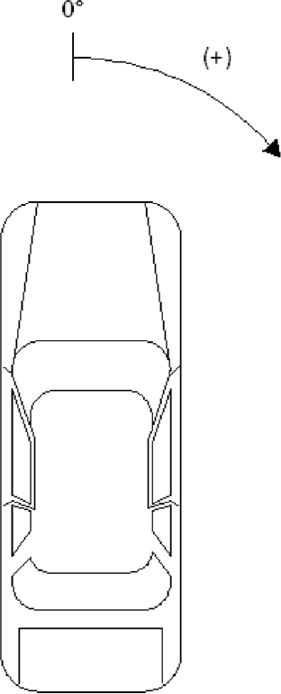
| ROADSIDE TABLE | DEPARTURE HEADING |
Departure Heading
| Screen Name: | Departure Heading |
| Data Table: | Roadside |
| Variable: | DepHeading |
Element Attributes:
| [0, 359] | Departure heading (degrees) |
| -999 | Unknown |
Source:
Table 77. Populating the NCHRP 17-88 DepHeading Variable
| Source Database | Data Collection Type | Variable(s) Used | Notes |
|---|---|---|---|
| SHRP 2/RID | NA | - | DepHeading is not applicable. |
| NCHRP 17-43 | Researcher Determined | - | Direct measurement of scaled scene diagram. |
| IA Datasets | NA | - | Detailed vehicle heading data not available from state data sources. |
| WA Datasets | NA | - | |
| TN Datasets | NA | - | |
| MCCS | Derived from Source | DepHeading | DepHeading is used to determine the angle of departure based on vehicle orientation and the line tangent to the roadway at that point of departure. All unknown angles are coded as DepHeading = -999. |
| NCHRP 22-26 | Researcher Determined | - | Direct measurement of scaled scene diagram. |
| LTCCS | Researcher Determined | - | Direct measurement of scaled scene diagram. |
Remarks:
This variable gives the angle between the vehicle orientation and a line tangent to the roadway at the point of departure.
- Departure headings between 0° and 180° indicate that the vehicle is angled to the right with respect to the line tangent to the roadway at the point of departure.
- Departure headings between 180.1° and 359.9° indicate that the vehicle is angled to the left with respect to the line tangent to the roadway at the point of departure.
- For departure headings where the trajectory point location is not clear, approximate the heading by interpolating between the two surrounding trajectory points.
If a vehicle departs the traveled way and enters the median on a divided roadway, this will be considered a point of departure if one of the conditions is satisfied:
- The vehicle strikes an object in the roadway median.
- The vehicle’s final resting position is in the roadway median.
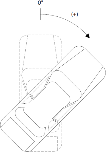
| EVENT TABLE | EVENT NUMBER |
Event Number
| Screen Name: | Event Number |
| Data Table: | Event |
| Variable: | EventNo |
Element Attributes:
| Positive integers | Event number |
| -999 | Unknown |
Source:
Table 78. Populating the NCHRP 17-88 EventNo Variable
| Source Database | Data Collection Type | Variable(s) Used | Notes |
|---|---|---|---|
| SHRP 2/RID | Direct from Source | ||
| NCHRP 17-43 | Direct from Source | ACCSEQ | NCHRP 17-43 uses ACCSEQ to identify an event that occurs during the crash. These are coded that each event is represented as an increasing positive integer during the crash. |
| IA Datasets | Direct from Source | SEQEVENTS1 - 4 | For reported crashes only; unreported crashes are coded as unknown. |
| WA Datasets | Direct from Source | EVENT1 - 4 | |
| TN Datasets | Direct from Source | EVENT_SEQ1 – 10 | |
| MCCS | Derived from Source | EventNo | MCCS indicates the events on the scaled scene diagram. |
| NCHRP 22-26 | Derived from Source | No. of Impacts | NCHRP 22-26 indicates some events on scaled scene diagram and in crash summary. The No. of Impacts variable determines to number of impacts during a crash. |
| LTCCS | Direct from Source | EventNumber | LTCCS uses EventNumber to identify a particular event in a sequence of accidents. These are coded the same way as coded above. |
Remarks:
This variable assigns a number to the crash event(s) that occurred during the encroachment. The first event is coded as EventNo = 1, and every subsequent event is counted from the first event.
| EVENT TABLE | ENCROACHMENT EXTENT |
Encroachment Extent
| Screen Name: | Lateral and Longitudinal Extent of Encroachment |
| Data Table: | Event |
| Variable: | LatExtent, LongExtent |
Element Attributes:
| ℝ | Maximum lateral or longitudinal distance of encroachment (meters) |
| -999 | Unknown |
Source:
Table 79. Populating the NCHRP 17-88 LatExtent and LongExtent Variables
| Source Database | Data Collection Type | Variable(s) Used | Notes |
|---|---|---|---|
| SHRP 2/RID | Direct from Source | ||
| NCHRP 17-43 | Researcher Determined | - | Direct measurement of scaled scene diagram. |
| IA Datasets | NA | - | Detailed vehicle trajectory information not available from state data sources. |
| WA Datasets | NA | - | |
| TN Datasets | NA | - | |
| MCCS | Researcher Determined | LatExtent, LongExtent | The LatExtent and LongExtent variables are used to determine the distance of encroachment in meters. All unknowns are coded as LatExtent = -999 and LongExtent = -999. |
| NCHRP 22-26 | Researcher Determined | - | Direct measurement of scaled scene diagram. |
| LTCCS | Researcher Determined | - | Direct measurement of scaled scene diagram. |
Remarks:
This variable encodes the farthest lateral and longitudinal position that the vehicle is located with respect to the point of departure in meters; this point does not necessarily have to be a point of impact or rollover trip.
| EVENT TABLE | IMPACT POSITION |
Impact Point Position
| Screen Name: | Impact Point Lateral and Longitudinal Position |
| Data Table: | Event |
| Variable: | ImpLat, ImpLong |
Element Attributes:
| ℝ | Lateral or longitudinal position relative to the point of departure (meters) |
| -999 | Unknown |
Source:
Table 80. Populating the NCHRP 17-88 ImpLat and ImpLong Variables
| Source Database | Data Collection Type | Variable(s) Used | Notes |
|---|---|---|---|
| SHRP 2/RID | NA | - | ImpLat and ImpLong are not applicable. |
| NCHRP 17-43 | Researcher determined | - | Direct measurement of scaled scene diagram. |
| IA Datasets | NA | - | Detailed vehicle trajectory information not available from state data sources. |
| WA Datasets | NA | - | |
| TN Datasets | NA | - | |
| MCCS | Derived from Source/Researcher determined | ImpLat, ImpLong | The ImpLat and ImpLong variables are used to determine the distance between the point of departure and impact in meters. All unknowns are coded as ImpLat = -999 and ImpLong = -999. |
| NCHRP 22-26 | Researcher determined | - | Direct measurement of scaled scene diagram. |
| LTCCS | Researcher determined | - | Direct measurement of scaled scene diagram. |
Remarks:
This variable encodes the lateral and longitudinal distance between the point of departure and point of impact of an event in meters. ImpLat and ImpLong should be coded for each event that occurs in a case. For rollover events, ImpLat and ImpLong is the trip point of the rollover.
| EVENT TABLE | IMPACT SPEED |
Impact Speed
| Screen Name: | Impact Speed |
| Data Table: | Event |
| Variable: | ImpSpeed |
Element Attributes:
| x ≥ 0 | Impact speed (kph) |
| -999 | Unknown |
Source:
Table 81. Populating the NCHRP 17-88 ImpSpeed Variable
| Source Database | Data Collection Type | Variable(s) Used | Notes |
|---|---|---|---|
| SHRP 2/RID | NA | - | ImpSpeed is not applicable. |
| NCHRP 17-43 | Researcher Determined | - | The 17-43 research team reconstructed the impact speed based on the WinSMASH impact delta-v and the energy absorbed by the impacted object. |
| IA Datasets | NA | - | Sufficient crash details not present in the state data to determine impact speed. Coded as unknown. |
| WA Datasets | NA | - | |
| TN Datasets | NA | - | |
| MCCS | NA | - | Sufficient crash details are not present in MCCS to determine impact speed. Coded as unknown. |
| NCHRP 22-26 | NA | - | Sufficient crash details are not present in NCHRP 22-26 to determine impact speed. Coded as unknown. |
| LTCCS | NA | - | Sufficient crash details are not present in LTCCS to determine impact speed. Coded as unknown. |
Remarks:
This variable gives the vehicle speed at the point of impact in kilometers per hour. ImpSpeed should be coded for each impact event that occurs in a case. This variable cannot be determined from the case viewer and will instead be determined from the event reconstruction protocol.
- For rollover events, ImpSpeed is the vehicle’s speed at its trip point (the last point on the CDS crash scene diagram where all four of the vehicle’s wheels are in contact with the ground).
- For final rest events, ImpSpeed = 0.
| EVENT TABLE | IMPACT ANGLE |
Impact Angle
| Screen Name: | Impact Angle |
| Data Table: | Event |
| Variable: | ImpAngle |
Element Attributes:
| [0, 359] | Impact angle (degrees) |
| -999 | Unknown |
Source:
Table 82. Populating the NCHRP 17-88 ImpAngle Variable
| Source Database | Data Collection Type | Variable(s) Used | Notes |
|---|---|---|---|
| SHRP 2/RID | NA | - | ImpAngle is not applicable. |
| NCHRP 17-43 | Researcher Determined | - | Direct measurement of scaled scene diagram. |
| IA Datasets | NA | - | Sufficient crash details not present in the state data to determine impact angle. Coded as unknown. |
| WA Datasets | NA | - | |
| TN Datasets | NA | - | |
| MCCS | Researcher Determined | ImpAngle | The ImpAngle variable is used to determine departure side based on the angle between vehicle trajectory and the line tangent to the roadway at impact. All unknowns are coded as ImpAngle = -999. |
| NCHRP 22-26 | Researcher Determined | - | Direct measurement of scaled scene diagram. |
| LTCCS | Researcher Determined | - | Direct measurement of scaled scene diagram. |
Remarks:
This variable gives the angle between the vehicle trajectory and a line tangent to the roadway at the point of impact.
- Impact angles between 0° and 180° indicate that the vehicle is departing on the right side of the roadway.
- Impact angles between 180.1° and 359.9° indicate that the vehicle is departing the road on the left side.
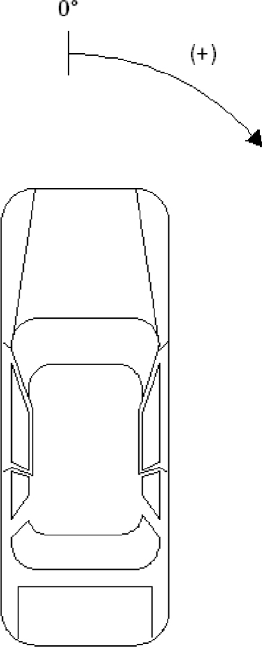
| EVENT TABLE | IMPACT HEADING |
Impact Heading
| Screen Name: | Impact Heading |
| Data Table: | Event |
| Variable: | ImpHeading |
Element Attributes:
| [0, 359] | Impact heading (degrees) |
| -999 | Unknown |
Source:
Table 83. Populating the NCHRP 17-88 ImpHeading Variable
| Source Database | Data Collection Type | Variable(s) Used | Notes |
|---|---|---|---|
| SHRP 2/RID | NA | - | ImpHeading is not applicable. |
| NCHRP 17-43 | Researcher Determined | - | Direct measurement of scaled scene diagram. |
| IA Datasets | NA | - | Detailed vehicle heading data not available from state data sources. |
| WA Datasets | NA | - | |
| TN Datasets | NA | - | |
| MCCS | Researcher Determined | ImpHeading | ImpHeading is used to determine the angle of vehicle orientation relative to the line tangent to the roadway at impact. All unknowns are coded as ImpHeading = -999. |
| NCHRP 22-26 | Researcher Determined | - | Direct measurement of scaled scene diagram. |
| LTCCS | Researcher Determined | - | Direct measurement of scaled scene diagram. |
Remarks:
This variable gives the angle between the vehicle orientation and a line tangent to the roadway at the point of impact.
- Impact headings between 0° and 180° indicate that the vehicle is angled to the right with respect to the line tangent to the roadway at the point of departure.
- Impact headings between 180.1° and 359.9° indicate that the vehicle is angled to the left with respect to the line tangent to the roadway at the point of departure.
- For impact headings where the trajectory point location is not clear, approximate the heading by interpolating between the two surrounding trajectory points.
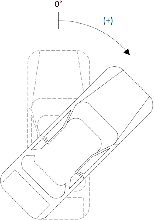
| EVENT TABLE | GENERAL AREA OF DAMAGE |
General Area of Damage (GAD)
| Screen Name: | General Area of Damage |
| Data Table: | Event |
| Variable: | GAD |
Element Attributes:
| 0 | None/Not a collision |
| 1 | Front |
| 2 | Rear |
| 3 | Left |
| 4 | Right |
| 5 | Top |
| 6 | Undercarriage |
| -999 | Unknown |
Source:
Table 84. Populating the NCHRP 17-88 GAD Variable
| Source Database | Data Collection Type | Variable(s) Used | Notes |
|---|---|---|---|
| SHRP 2/RID | NA | - | GAD is not applicable. |
| NCHRP 17-43 | Direct from source | GADEV1 | NCHRP 17-43 codes the general area of damage as letters to corresponding region of the vehicle. |
| IA Datasets | Direct from source | MostDamage | Captured only for reported single event collisions as the source data only captures the most damaged area of the vehicle (and not the damaged area for each impact). Coded as unknown for unreported crashes |
| WA Datasets | NA | - | Not available in WA crash data. |
| TN Datasets | Direct from source | AREASOFVEHICLEDAMAGE1 | |
| MCCS | NA | - | Not available in MCCS crash data |
| NCHRP 22-26 | Derived from Source/Researcher determined | Left Side Damage, Right Side Damage, and Handlebar Damage | NCHRP 22-26 does not specify the GAD. Information about damage to different areas of the motorcycle and scene photographs of the vehicle use to determine the GAD. GAD is not coded for riders/passengers. |
| Source Database | Data Collection Type | Variable(s) Used | Notes |
|---|---|---|---|
| LTCCS | Derived from source | DeformLocation | LTCCS classifies the general area of damage for both the truck cab and trailer. These codes correlate to the codes above. |
Remarks:
This variable describes the general area of damage on the vehicle due to the event. The six areas of damage are represented in Figure 20. and Figure 21.
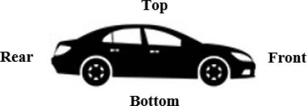
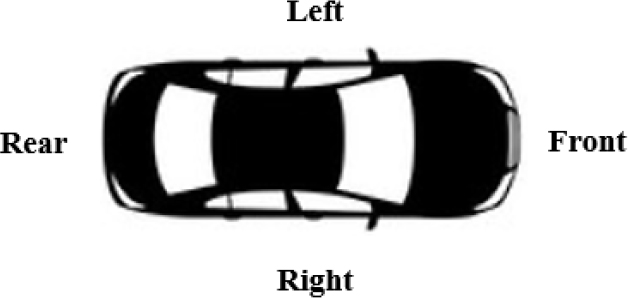
| EVENT TABLE | SPECIFIC HORIZONTAL LOCATION OF IMPACT |
Specific Horizontal Location of Impact
| Screen Name: | Specific Horizontal Location of Impact |
| Data Table: | Event |
| Variable: | SHL |
Element Attributes:
| 0 | None/Not a collision |
| 1 | Left (front or rear GAD) |
| 2 | Right (front or rear GAD) |
| 3 | Center (front or rear GAD) |
| 4 | Front (side, top, or undercarriage GAD) |
| 5 | Rear (side, top, or undercarriage GAD) |
| 6 | Center (side, top, or undercarriage GAD) |
| 7 | Distributed |
| -999 | Unknown |
Source:
Table 85. Populating the NCHRP 17-88 SHL Variable
| Source Database | Data Collection Type | Variable(s) Used | Notes |
|---|---|---|---|
| SHRP 2/RID | NA | - | SHL is not applicable. |
| NCHRP 17-43 | Direct from source | SHL1, SHL2 | NCHRP 17-43 describes the highest and second highest specific longitudinal location of impact. These are coded as letters to the corresponding horizontal location of impact. |
| IA Datasets | NA | - | SHL data is not available from the state data sources. |
| WA Datasets | NA | - | |
| TN Datasets | NA | - | |
| MCCS | NA | - | Not available in MCCS crash data. |
| NCHRP 22-26 | Researcher Determined/Derived from Source | Left Side Damage, Right Side Damage, and Handlebar Damage | NCHRP 22-26 does not specify the SHL. Information about damage to different areas of the motorcycle and scene photographs of the vehicle use to determine the SHL. SHL is not coded for riders/passengers. |
| LTCCS | Derived from source | DeformLong | LTCCS describes the SHL for both the truck cab and trailer. These codes correlate to the codes above. |
Remarks:
This variable describes the distribution of damage on the vehicle due to the event. The same vehicle conventions (front, rear, left, right, top, undercarriage) are used for both GAD and SHL.
| EVENT TABLE | TYPE OF OBJECT STRUCK |
Type of Object Struck
| Screen Name: | Type of Object Struck |
| Data Table: | Event |
| Variable: | ObjType |
Element Attributes:
| 0 | None/not a collision |
| 1 | Guardrail End Terminal |
| 2 | Guardrail Length of Need |
| 3 | Bridge rail |
| 4 | Bridge Pier/abutment |
| 5 | Cable barrier |
| 6 | Concrete barrier |
| 7 | Pole |
| 8 | Tree |
| 9 | Landscape/shrubbery |
| 10 | Embankment |
| 11 | Culvert/ditch |
| 12 | Crash cushion |
| 13 | Rollover |
| 14 | Jackknife |
| 15 | Parked Vehicle |
| 16 | Water |
| 17 | Curb |
| 18 | Fence |
| 19 | Wall/building |
| 20 | Fire Hydrant |
| 21 | Signpost |
| 22 | Fire/explosion |
| 23 | Pedestrian |
| 24 | Final rest event |
| 88 | Other |
| -999 | Unknown |
Source:
Table 86. Populating the NCHRP 17-88 ObjType Variable
| Source Database | Data Collection Type | Variable(s) Used | Notes |
|---|---|---|---|
| SHRP 2/RID | NA | - | ObjType is not applicable. |
| NCHRP 17-43 | Direct from Source | OBJCONT | The OBJCONT variable maps closely with the attributes listed above. NCHRP 17-43 includes vehicle numbers, size of objects, like poles, and other nonfixed objects. |
| IA Datasets | Direct from Source | SEQEVENTS1 - 4 | The SEQEVENTS variables map closely with the attributes listed above. Utility poles, other post/poles and traffic signal supports are coded as 7. |
| WA Datasets | Direct from Source | OBJECT1, 2 | The OBJECT variables map relatively closely with the attributes listed above. Luminaire pole, utility pole and traffic signal pole/equipment coded as 7. Rock bank, earth bank and over embankment coded as 10. |
| TN Datasets | Direct from Source | EVENT_SEQ1 – 10 | The EVENT_SEQ variables map closely with the attributes listed above. All embankment types are combined (earth, rock, unknown material) and coded as 10. Utility poles, other post/poles and traffic signal supports are coded as 7. |
| MCCS | Derived from Source | ObjType | ObjType is used to distinguish the object struck at impact. If there is no object struck, then it is coded as ObjType = 0. All unknowns are coded as ObjType = -999. |
| NCHRP 22-26 | Derived from Source | Barrier Information | Barrier Information lists the different information about the initial object impacted. Crash summary is also used to determine any other objects impacted. |
| LTCCS | Derived from Source | CDCObjectContact | LTCCS classifies over 70 different objects which can be categorized into the codes above. |
Remarks:
This variable is used to provide more detailed information about the roadside object struck.
- The final rest event indicator (ObjType = 24) is used to capture the trajectory that spans from the last event to the final rest of the vehicle.
- Vehicles that strike an object that are above the road (overpasses, bridges, etc.) should be coded as ObjType = 88. An example of this scenario is shown in Figure 22.
| EVENT TABLE | BREAKAWAY DEVICE |
Breakaway Device
| Screen Name: | Breakaway Device |
| Data Table: | Event |
| Variable: | Breakaway |
Element Attributes:
| 0 | Not a breakaway device |
| 1 | Breakaway device |
| -998 | Not applicable device |
| -999 | Unknown |
Source:
Table 87. Populating the NCHRP 17-88 Breakaway Variable
| Source Database | Data Collection Type | Variable(s) Used | Notes |
|---|---|---|---|
| SHRP 2/RID | NA | - | Breakaway is not applicable. |
| NCHRP 17-43 | Derived from Source | - | NCHRP 17-43 crash summary provides specific information whether a signpost or pole is a breakaway device. |
| IA Datasets | NA | This data is not available for the state datasets. | |
| WA Datasets | NA | ||
| TN Datasets | NA | ||
| MCCS | Derived from Source | Breakaway | Breakaway is used to determine whether the object struck at impact is designed to be a breakaway device. If it is not a breakaway, it is coded as Breakaway = 0. All unknowns are coded as Breakaway = -999. |
| NCHRP 22-26 | Derived from Source | Barrier Information | Barrier Information lists the different information about the initial object impacted, including the type of post contacted. Crash summary is also used to determine if any object is a breakaway device. |
| LTCCS | Direct from source | CDCObjectContact | LTCCS classifies poles/posts as either breakaway or nonbreakaway. |
Remarks:
This variable indicates whether the device is designed to breakaway. Breakaway = -998 if the ObjType is not a pole or signpost.
| EVENT TABLE | OBJECT CLARIFICATION |
Object Clarification
| Screen Name: | Object Clarification |
| Data Table: | Event |
| Variable: | ObjClarify |
Element Attributes:
| Text entry | Object clarification |
Source:
Table 88. Populating the NCHRP 17-88 ObjClarify Variable
| Source Database | Data Collection Type | Variable(s) Used | Notes |
|---|---|---|---|
| SHRP 2/RID | NA | - | ObjClarify is not applicable. |
| NCHRP 17-43 | Derived from Source | - | NCHRP 17-43 crash summary provides information about each event and object impacted. |
| IA Datasets | Direct from Source | TYPE | Iowa maintenance inventory data has some data on type of device (e.g., w-beam vs. thrie beam), concrete barrier shape, and crash cushion type. When this information is present, it has been included, primarily for the unreported crashes. |
| WA Datasets | Direct from Source | AttributeValue | In addition to identifying roadside hardware type (e.g., guardrail, cable barrier, impact attenuator), Washington State DOT inventory data has some limited additional information, primarily whether a cable barrier is high or low tension. When this information is present, it has been included, primarily for the unreported crashes. |
| TN Datasets | Direct from Source | FEAT_CHAR | TN ETRIMS data provides some limited additional data on certain roadside hardware, primarily identifying flared end terminals from tangent terminals. When this information is present, it has been included, primarily for the unreported crashes. |
| MCCS | Derived from Source | ObjClarify | MCCS data provides additional information about each event and its corresponding object struck at impact. |
| NCHRP 22-26 | Derived from Source | - | NCHRP 22-26 crash summary provides information about each event and object impacted. |
| Source Database | Data Collection Type | Variable(s) Used | Notes |
|---|---|---|---|
| LTCCS | Direct from Source | CDCObjectContact | LTCCS provides specific information on certain roadside hardware and vehicles that were contacted during an event. |
Remarks:
This variable provides additional details about the object struck. This could be used to indicate the specific barrier type. If the ObjType = 88 (other), then this variable must contain a description of the object.
| EVENT TABLE | OBJECT OFFSET |
Object Offset
| Screen Name: | Object Offset |
| Data Table: | Event |
| Variable: | ObjOffset |
Element Attributes:
| x ≥ 0 | Lateral distance from the road edge to the object struck (meters) |
| -999 | Unknown |
Source:
Table 89. Populating the NCHRP 17-88 ObjOffset Variable
| Source Database | Data Collection Type | Variable(s) Used | Notes |
|---|---|---|---|
| SHRP 2/RID | NA | - | ObjOffset is not applicable. |
| NCHRP 17-43 | Researcher Determined | - | Direct measurement of scaled scene diagram. |
| IA Datasets | NA | - | Data not captured for this state |
| WA Datasets | Researcher Determined | - | Lateral offset for longitudinal barriers (guardrail, concrete and cable) and crash cushions available for the 12 selected routes. All offsets are relative to the nearest travel lane edge line. |
| TN Datasets | NA | - | Data not captured for this state |
| MCCS | Derived from Source/Researcher Determined | ObjOffset | Direct measurement of scaled scene diagram. |
| NCHRP 22-26 | Researcher Determined | - | Direct measurement of scaled scene diagram. |
| LTCCS | Researcher Determined | - | Direct measurement of scaled scene diagram. |
Remarks:
This variable encodes the lateral distance from the edge of the traveled way to the object struck in meters. If the object struck is not drawn on the crash scene diagram, then ObjOffset will be approximated by using the distance between the edge of the traveled way and the vehicle CG where the impact occurred. For left side departures with a median, the traveled way is the leftmost lane in the direction of travel if the impacted object is in the median. If the object is not in the median, the offset is measured to the closest lane.
| EVENT TABLE | OBJECT INFLUENCE |
Object Influence
| Screen Name: | Object Influence |
| Data Table: | Event |
| Variable: | ObjInfluence |
Element Attributes:
| 0 | No |
| 1 | Yes |
| -999 | Unknown/not applicable |
Source:
Table 90. Populating the NCHRP 17-88 ObjInfluence Variable
| Source Database | Data Collection Type | Variable(s) Used | Notes |
|---|---|---|---|
| SHRP 2/RID | NA | - | ObjInfluence is not applicable. |
| NCHRP 17-43 | Researcher Determined | - | Based on the crash summary and observation of the scaled scene diagram. |
| IA Datasets | NA | - | Data not available from state data sources. Coded as unknown. |
| WA Datasets | NA | - | |
| TN Datasets | NA | - | |
| MCCS | Researcher Determined | ObjInfluence | The ObjInfluence variable determines if there was any object present at the point of departure. All unknowns are coded as ObjInfluence = -999. |
| NCHRP 22-26 | Researcher Determined | - | Based on the crash summary and observation of the scaled scene diagram. |
| LTCCS | Researcher Determined | - | Based on the crash summary and observation of the scaled scene diagram. |
Remarks:
This variable indicates whether the roadway/roadside object influenced the trajectory of the vehicle. For rollover and final rest events, ObjInfluence = -999.
| ENCROACHMENT TRAJECTORY TABLE | COMPONENT NUMBER |
Component Number
| Screen Name: | Component Number |
| Data Table: | Trajectory |
| Variable: | Component |
Element Attributes:
| 0 | Cab |
| 1, 2, 3, … | Trailer number |
| -998 | Not applicable |
| -999 | Unknown |
Source:
See Table 61 for details on the source of this variable.
Remarks:
This variable differentiates between the cab and trailer(s) for passenger cars and large trucks.
- If the vehicle is not towing a trailer, then Component = -998.
- The trailer nearest to the cab should be specified as Component = 1. Any subsequent trailers should be counted in series from the first trailer.
This variable differentiates between the motorcycle and rider(s) for motorcycle impacts.
- The driver of the motorcycle, if specified, should be specified as Component = 1. Any other riders should be counted in series.
| ENCROACHMENT TRAJECTORY TABLE | COMPONENT SEPARATION |
Component Separation
| Screen Name: | Component Separation |
| Data Table: | Trajectory |
| Variable: | Separated |
Element Attributes:
| 0 | No separation |
| 1 | Separation occurred |
| -998 | Not applicable |
| -999 | Unknown |
Source:
Table 91. Populating the NCHRP 17-88 Separated Variable
| Source Database | Data Collection Type | Variable(s) Used | Notes |
|---|---|---|---|
| SHRP 2/RID | NA | - | Separated is not applicable. |
| NCHRP 17-43 | Researcher Determined | - | Scaled scene diagram and crash summary is used to determine whether separation of a component happened during the crash. |
| IA Datasets | NA | - | This data element not readily available in the state datasets. |
| WA Datasets | NA | - | |
| TN Datasets | NA | - | |
| MCCS | Researcher Determined | Separated | The Separated variable determines whether the riders ejected off the motorcycles. All unknowns are coded as Separated = -999. |
| NCHRP 22-26 | Derived from Source/Researcher Determined | Ejected | Ejected variable determines whether the riders ejected off the motorcycle. Scaled scene diagram and crash summary is used to determine which event the rider ejected off the motorcycle. |
| LTCCS | Researcher Determined | - | Scaled scene diagram and crash summary is used to determine whether separation of a component happened during the crash. |
Remarks:
This variable specifies if the cab and trailer(s) separated for large trucks. If the vehicle is not towing a trailer, then Separated = -998. For NCHRP 22-26, this variable specifies if a rider or passenger separates from the motorcycle.
| ENCROACHMENT TRAJECTORY TABLE | DEPARTURE NUMBER |
Departure Number
| Screen Name: | Departure Number |
| Data Table: | Trajectory |
| Variable: | NumDepart |
Element Attributes:
| Positive integers | Departure Number (including partial departures) |
| -999 | Unknown |
Source:
See Table 62 for details on the source of this variable.
Remarks:
This variable encodes an integer that counts how many departures have occurred; when multiple departures occur, the count should be tallied here. If a partial departure occurs, NumDepart should be increased by one only if the partial departure becomes a full departure.
| ENCROACHMENT TRAJECTORY TABLE | EVENT NUMBER |
Event Number
| Screen Name: | Event Number |
| Data Table: | Trajectory |
| Variable: | EventNo |
Element Attributes:
| Positive integers | Event number |
| -999 | Unknown |
Source:
See Table 78 for more details on the sources for event number.
Remarks:
This variable assigns a number to the event(s) that occurred during the event. The first event is coded as EventNo = 1, and every subsequent event is counted from the first event. The event number coded also corresponds to the event number in the original dataset. For departures without a collision, the event number is always 1.
| ENCROACHMENT TRAJECTORY TABLE | TRAJECTORY POINT NUMBER |
Trajectory Point Number
| Screen Name: | Trajectory Point Number |
| Data Table: | Trajectory |
| Variable: | PointNo |
Element Attributes:
| 1, 2, 3, … | Trajectory point number |
| -999 | Unknown |
Source:
Table 92. Populating the NCHRP 17-88 PointNo Variable
| Source Database | Data Collection Type | Variable(s) Used | Notes |
|---|---|---|---|
| SHRP 2/RID | Direct from Source | ||
| NCHRP 17-43 | Researcher Determined | - | Direct measurement of scaled scene diagram. |
| IA Datasets | NA | - | Detailed vehicle trajectory data not available from the state data sources. |
| WA Datasets | NA | - | |
| TN Datasets | NA | - | |
| MCCS | Researcher Determined | PointNo | Direct measurement of scaled scene diagram. |
| NCHRP 22-26 | Researcher Determined | - | Direct measurement of scaled scene diagram. |
| LTCCS | Researcher Determined | - | Direct measurement of scaled scene diagram. |
Remarks:
This variable assigns a number to the trajectory point(s) that occurred during the event. The first trajectory point is coded as PointNo = 1, and every subsequent point is counted from the first trajectory point. PointNo resets to PointNo = 1 whenver EventNo changes in value.
| ENCROACHMENT TRAJECTORY TABLE | TRAJECTORY POINT POSITION |
Trajectory Point Position
| Screen Name: | Trajectory Point Lateral and Longitudinal Position |
| Data Table: | Trajectory |
| Variable: | TrajLat, TrajLong |
Element Attributes:
| ℝ | Lateral and longitudinal position relative to the point of departure (meters) |
| -999 | Unknown |
Source:
Table 93. Populating the NCHRP 17-88 TrajLat and TrajLong Variables
| Source Database | Data Collection Type | Variable(s) Used | Notes |
|---|---|---|---|
| SHRP 2/RID | Direct from Source | ||
| NCHRP 17-43 | Researcher Determined | - | Direct measurement of scaled scene diagram. |
| IA Datasets | NA | - | Detailed vehicle trajectory information not available from the state data sources. |
| WA Datasets | NA | - | |
| TN Datasets | NA | - | |
| MCCS | Researcher Determined | TrajLat, TrajLong | The TrajLat and TrajLong variables are used to determine the vehicle’s position between departure point and trajectory point in meters. All unknowns are coded as TrajLat = -999 and TrajLong = -999. |
| NCHRP 22-26 | Researcher Determined | - | Direct measurement of scaled scene diagram. |
| LTCCS | Researcher Determined | - | Direct measurement of scaled scene diagram. |
Remarks:
This variable encodes the lateral and longitudinal distance between the point of departure and trajectory point in meters.
| ENCROACHMENT TRAJECTORY TABLE | TRAJECTORY POINT HEADING |
Trajectory Point Heading
| Screen Name: | Trajectory Point Heading |
| Data Table: | Trajectory |
| Variable: | TrajHeading |
Element Attributes:
| [0, 359] | Trajectory point heading (degrees) |
| -999 | Unknown |
Source:
Table 94. Populating the NCHRP 17-88 TrajHeading Variable
| Source Database | Data Collection Type | Variable(s) Used | Notes |
|---|---|---|---|
| SHRP 2/RID | NA | - | TrajHeading is not applicable. |
| NCHRP 17-43 | Researcher Determined | - | Direct measurement of scaled scene diagram. |
| IA Datasets | NA | - | Detailed vehicle trajectory/heading information not available from the state data sources. |
| WA Datasets | NA | - | |
| TN Datasets | NA | - | |
| MCCS | Researcher Determined | TrajHeading | TrajHeading is used to determine the angle of departure based on vehicle orientation and the line tangent to the roadway at that point of departure. All unknown angles are coded as TrajHeading = -999. |
| NCHRP 22-26 | Researcher Determined | - | Direct measurement of scaled scene diagram. |
| LTCCS | Researcher Determined | - | Direct measurement of scaled scene diagram. |
Remarks:
This variable gives the angle between the vehicle orientation and a line tangent to the roadway at each trajectory point.
- Trajectory headings between 0° and 180° indicate that the vehicle is angled to the right with respect to the line tangent to the roadway at the point of departure.
- Trajectory headings between 180.1° and 359.9° indicate that the vehicle is angled to the left with respect to the line tangent to the roadway at the point of departure.
- For trajectory headings where the trajectory point location is not clear, approximate the heading by interpolating between the two surrounding trajectory points.

| ENCROACHMENT TRAJECTORY TABLE | TRACKING CONDITION |
Tracking Condition
| Screen Name: | Tracking Condition |
| Data Table: | Trajectory |
| Variable: | Tracking |
Element Attributes:
| 1 | Tracking |
| 2 | Longitudinal skid |
| 3 | Lateral skid clockwise |
| 4 | Lateral skid counterclockwise |
| 5 | Jackknife |
| 88 | Other |
| -999 | Unknown |
Source:
Table 95. Populating the NCHRP 17-88 Tracking Variable
| Source Database | Data Collection Type | Variable(s) Used | Notes |
|---|---|---|---|
| SHRP 2/RID | NA | - | Tracking is not applicable. |
| NCHRP 17-43 | Derived from Source | PREISTAB | The PREISTAB variable represents the pre-impact stability and is coded closely to above. NCHRP 17-43 includes No avoidance maneuver = 0, No driver = 1 and does not include Jackknife. |
| IA Datasets | NA | - | Detailed vehicle trajectory/heading information not available from the state data sources. |
| WA Datasets | NA | - | |
| TN Datasets | NA | - | |
| MCCS | Researcher Determined | Tracking | The Tracking variable is used to determine the type of stability before departure and impact. All unknowns are coded as Tracking = -999. |
| NCHRP 22-26 | Researcher Determined | - | Use of scaled scene diagram and crash summary used to determine if the components are tracking. |
| LTCCS | Derived from Source | ACRStability, OVEStability, ACRJackknife, OVEJackKnife | The ACRStability and OVEStability variables represent the stability after the critical event. Other is coded as ACRStability and OVEStability = 8. Unknown is coded as ACRStability and OVEStability = 9. For the the evevn the large truck jackknifes, the variable ACRJackknife and OVEJackKnife are used to idenifty whether a jackknife was present or not. A |
| Source Database | Data Collection Type | Variable(s) Used | Notes |
|---|---|---|---|
| jackknife that is absent is coded as ACRJackknife and OVEJackKnife = 0. A jackknife that is present is coded as ACRJackknife and OVEJackKnife = 1. |
Remarks:
This variable describes the vehicle’s stability at the point of departure. If no description of vehicle stability is in the original data source record, skid/tire marks or vehicle orientation on the CDS crash scene diagram may also indicate any signs of instability.
- For vehicles that are rolling over, Tracking = 88.
- The only exception to this rule is the trip point of the rollover (the last point on the CDS crash scene diagram where all four of the vehicle’s wheels are in contact with the ground). At the trip point, the tracking condition of the vehicle prior to the crash should be used.
- For large trucks that are jackknifing, Tracking = 5.
| ENCROACHMENT TRAJECTORY TABLE | BRAKING PRESENCE |
Braking Presence
| Screen Name: | Braking Presence |
| Data Table: | Trajectory |
| Variable: | BrakePresence |
Element Attributes:
| 0 | No |
| 1 | Yes |
| -999 | Unknown |
Source:
Table 96. Populating the NCHRP 17-88 BrakePresence Variable
| Source Database | Data Collection Type | Variable(s) Used | Notes |
|---|---|---|---|
| SHRP 2/RID | NA | - | BrakePresence is not applicable. |
| NCHRP 17-43 | Researcher Determined | - | Determined using available crash scene diagram/crash narrative along with the available crash scene photographs. |
| IA Datasets | NA | - | Detailed vehicle trajectory/braking information not available from the state data sources. |
| WA Datasets | NA | - | |
| TN Datasets | NA | - | |
| MCCS | Researcher Determined | BrakeExtent | The BrakeExtent variable is used to specify whether or not the driver was braking before impact occurred. If braking was present, then it is coded as BrakeExtent = 1. All unknowns are coded as BrakeExtent = -999. |
| NCHRP 22-26 | NA | - | Detailed braking information not available for NCHRP 22-26. Coded as Unknown. |
| LTCCS | NA | - | Detailed vehicle trajectory/braking information not available from the LTCCS data sources. |
Remarks:
This variable specifies if the driver was braking during the event. If no description of braking is in the original data source record, skid/tire marks or vehicle orientation on the CDS crash scene diagram may also indicate whether braking occurred.
- For vehicles that are rolling over, BrakeExtent = 0.
- The only exception to this rule is the trip point of the rollover (the last point on the CDS crash scene diagram where all four of the vehicle’s wheels are in contact with the ground). At the trip point, the braking condition of the vehicle prior to the crash should be used.
| ENCROACHMENT TRAJECTORY TABLE | ROLLOVER EVENT |
Rollover Event
| Screen Name: | Rollover Event |
| Data Table: | Trajectory |
| Variable: | Rollover |
Element Attributes:
| 0 | No |
| 1 | Yes |
| 88 | Other |
| -999 | Unknown |
Source:
Table 97. Populating the NCHRP 17-88 Rollover Variable
| Source Database | Data Collection Type | Variable(s) Used | Notes |
|---|---|---|---|
| SHRP 2/RID | NA | - | Rollover is not applicable. |
| NCHRP 17-43 | Direct from Source/Researcher determined | Rollover | Rollover variable in NASS/CDS indicates the number of quarter turns. This is verified by the scaled scene diagram. |
| IA Datasets | Direct from Source | SEQEVENTS1 - 4 | SOE variables used to identify rollover presence. |
| WA Datasets | Direct from Source | EVENT1-4 | |
| TN Datasets | Direct from Source | EVENT_SEQ1 – 10 | |
| MCCS | Direct from Source/Researcher Determined | Rollover | The Rollover variable is used to determine if a rollover was present at the crash. |
| NCHRP 22-26 | Direct from Source/Researcher Determined | - | Use of scaled scene diagram and crash summary used to determine if the motorcycle experienced a rollover. Riders and passengers coded as 88. |
| LTCCS | Derived from Source/Researcher Determined | RolloverType | The RolloverType variable is used to determine if a rollover was present at the crash. |
Remarks:
This variable specifies if the vehicle or vehicle component rolled over during the event. In the CDS crash scene diagram, vehicles that have rolled over are indicated with trajectory points that are on the vehicle side or roof.
References
Carrigan, C.E., and M.H. Ray. 2018. “Consideration of Roadside Features in the Highway Safety Manual,” Draft Final Report, NCHRP Project 17-54.
CARSP. CARSP Canadian Vehicle Specifications. Canadian Association of Road Safety Professionals. https://www.carsp.ca/en/news-and-resources/advanced-vehiclesafety-systems/canadian-vehicle-specifications/
Dingus, T. A., et al., 2015. Naturalistic driving study: Technical coordination and quality control (no. SHRP 2 Report S2-S06-RW-1).
FMCSA, NHTSA, and National Center for Statistics and Analysis. 2006. Large Truck Event Causation Study Analytical User’s Manual. U.S. Department of Transportation.
Gabler, H.C., A. Daniello, D.J. Gabauer, W. Tatem, A. Tsoi, J. Stitzel, J. Sink, and S. Harris. 2021. “Factors Related to Serious Injury and Fatal Motorcycle Crashes with Traffic Barriers,” Draft Final Report, NCHRP Project 22-26.
Kusano, K. D., and H. C. Gabler. 2014. “Comprehensive target populations for current active safety systems using national event databases,” Traffic Injury Prevention, vol. 15, no. 7, pp. 753-761, doi: 10.1080/15389588.2013.871003.
Margiotta, R., and S. Washburn. 2017. Simplified Highway Capacity Calculation Method for the Highway Performance Monitoring System. Final Report PL-18-003. FHWA.
Nazemetz, J. W., F. D. Bents, J. G. Perry, C. P. Thor, and Y. M. Mohamedshah. 2019. Motorcycle Event Causation Study. Federal Highway Administration.
National Center for Statistics and Analysis (NCSA). (2016, September). National Automotive Sampling System – Crashworthiness Data System, 2015 Analytical User’s Manual. (Report No. DOT HS 812 321). National Highway Traffic Safety Administration.
Perez, M. A., J. Sudweeks, D. Viita, and J. Hankey. 2014. Lane Tracker Validation Final Report. p. 51.
Riexinger, L. E., and H. C. Gabler. 2020. “Expansion of NASS/CDS for characterizing run-off-road eventes,” Traffic Injury Prevention, pp. 1-5, doi: 10.1080/15389588.2020.1798942.


