Integrating Social and Behavioral Sciences Within the Weather Enterprise (2018)
Chapter: 4 Social and Behavioral Sciences for Road Weather Concerns
CHAPTER 4
Social and Behavioral Sciences for Road Weather Concerns
This chapter discusses the rationale for special focus on the application of social and behavioral sciences (SBS) research to road weather concerns (see Section 4.1), describes how the provision of weather information for driver safety is evolving over time (see Section 4.2), and characterizes the network of local, state, and federal actors involved in providing and responding to road weather information (see Section 4.3). The chapter also discusses the types of SBS research needed to address these complex dynamics.
4.1 THE MOTIVATION FOR ADVANCING SBS FOR ROAD WEATHER
Mobility is a fundamental element of life. The transportation network of roads, highways, bike paths, and pedestrian facilities provides a lifeline that connects people to jobs, schools, essential services, community, and recreation, and it facilitates commerce locally, regionally, and globally. In 2002 trucks moved 64% of the nation’s freight (Bureau of Transportation Statistics, 2016). The latest National Household Travel Survey in 2009 found that private vehicles are used for 83% of all the trips made (Santos et al., 2011), and of those trips, 17% were to and from work, 45% were for personal and family errands, and 25% were for social and recreational reasons (see Table 4.1). Our nation’s heavy reliance on the network of roads and highways makes it easy to see that any disruption that restricts traffic flow has major implications for our lives and our economy.
Weather has profound impacts on the transportation network and the safety of its users. In 1999, it was estimated that the total delay due to adverse weather on the nation’s freeways and principal arterials was approximately 24% of all non-recurring traffic congestion (Chin et al., 2002). Each year in the United States there are approximately 5.7 million vehicle crashes nationwide and 22% (1.3 million crashes) occur during adverse weather and where weather conditions are listed as a contributing factor (see Figure 4.1). While the numbers vary over time (see Figure 4.2a), on average 445,000 people are injured and almost 6,000 are killed annually due to vehicle accidents associated with adverse weather (FHWA, 2017b), which is more than nine times the number of fatalities of all the other National Weather Service (NWS)-tracked adverse weather fatalities combined (see Figure 4.2b).
TABLE 4-1 Annual Number and Percent of Person Trips by Mode and Purpose for Private Vehicles in 2009.
| Trips (millions) | Percent | |
|---|---|---|
| By Mode | ||
| Private vehicle | 327,118 | 83.4 |
| Transit | 7,520 | 1.9 |
| Walk | 40,962 | 10.4 |
| Other | 16,424 | 4.2 |
| By Purpose for Private Vehicle | ||
| To/from work | 55,969 | 17.1 |
| Work related business | 10,525 | 3.2 |
| Family/personal errands | 146,159 | 44.7 |
| School/church | 26,654 | 8.1 |
| Social and recreational | 82,887 | 25.3 |
| Other | 4,925 | 1.5 |
NOTE: This data was compiled using 2009 National Household Travel Survey which was composed of two major sample units. The first contained 25,000 households representing all 50 U.S. States and the District of Columbia. The second consisted of 20 states and Metropolitan Planning Organizations who collectively purchased an additional 125,000 household samples for their respective regions.
SOURCE: Adapted from Santos et al., 2011.
Road weather concerns deserve special attention for several reasons. Travelers are in a unique position to control their fate when it comes to decisions about making a trip during hazardous weather. Unlike cases where encountering a hazard is unavoidable (e.g., when a tornado approaches one’s home), drivers often choose to travel in the face of a weather hazard. Such choices involve personal valuations regarding the importance of making a particular trip at that particular time, balanced against perceived risks of injury or death. Better understanding the motivations and risk evaluations that people are making in such cases can aid the development of better strategies to discourage risky behavior. At the same time, if a driver already in transit encounters dangerous conditions (e.g., icy surfaces, low visibility, water-covered roadways), safe response actions are often very limited and not always clear; and if the “wrong” actions are taken, it can endanger not only the driver, but the occupants of many other vehicles as well. Knowing how to better prepare people for such situations, and to provide real-time information during such episodes is a critical need.
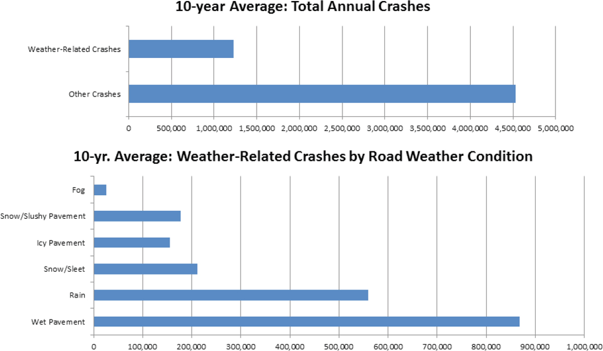
NOTE: Weather-related crashes are those that occur in the presence of adverse weather and/or slick pavement conditions. Additional factors such as rain, snow, and fog are not disaggregated from pavement conditions in this graphic; i.e., the percentage due to fog is for those crashes that occur under foggy conditions, but not wet, icy, or snowy pavement conditions.
SOURCE: Paul Pisano, Federal Highway Administration.
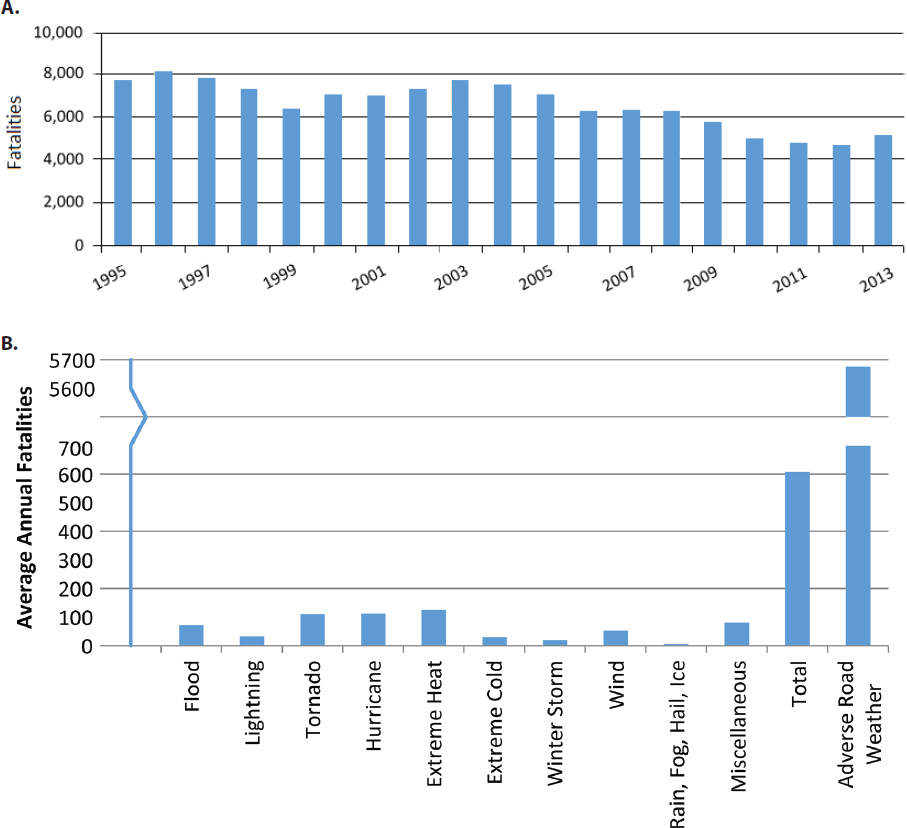
SOURCES: A: http://www.sirwec.org/Presentations/2016-ftcollins/010.pdf; B: Federal Highway Administration and National Weather Service.
Safety is a top priority for the U.S. Department of Transportation (USDOT), state Departments of Transportation (DOTs), and local public works authorities (FHWA, 2017c). Federal Highway Administration (FHWA) scientific leadership has helped advance the understanding of how adverse weather impacts the surface of the
roadway. State DOTs have invested heavily in advanced technologies to monitor and forecast pavement conditions and to offer site-specific road weather forecasts; and they continue to develop proactive strategies for responding to adverse weather conditions and providing information about road conditions to travelers. In addition, NWS can now provide site-specific weather warnings using highway mile markers, and Wireless Emergency Alerts (WEAs) can be activated by emergency management officials during certain extreme events. Yet, despite these many advances, every year hundreds of thousands of people continue to be injured or killed while traveling in a personal vehicle during adverse weather.
The report Where the Weather Meets the Road: A Research Agenda for Improving Road Weather Services suggests that automotive technologies such as anti-lock brakes, high-output lighting, and traction control have increased safety during normal driving conditions (NRC, 2004). As discussed earlier in this report, connected and autonomous vehicles are becoming more interactive with the roadway environment, and in the coming years, vehicles will have even more capabilities to compensate for poor driving conditions and a lack of driver abilities.
However, at the same time, these advances can lead to overconfidence in some people who drive during adverse weather conditions; motorists will still have the ability to make poor decisions, placing themselves and others at risk while driving in adverse weather conditions.
During hazardous weather, state highway agencies have the ability to make “directive communications,” such as closing highways and restricting travel, which can raise dynamic tensions between the paternalistic motivation to protect motorists and the economic motivation to avoid closing the transportation network. There are situations where closing highways is clearly warranted; for instance, in winter weather an interstate may be closed when reduction in visibility is so severe that the plow trucks cannot safely operate. Yet, this sometimes results in motorists then choosing to pursue alternate, secondary roads that are even less safe—thus illustrating how risk perceptions and ensuing decisions and behaviors can vary among motorists and result in unintended consequences. Many other situations fall into the realm of “informational communications,” where travelers have the responsibility to evaluate the need and urgency for a trip against the risk of making that trip during adverse weather. Such choices extend beyond a simple “go or no-go” decision, as they can also include choices about when to begin a trip, what transportation mode to use, and what route to choose.
With the majority of personal trips made for seemingly discretionary reasons (e.g., to run errands and for social/recreational purposes), why do motorists so often find themselves in hazardous driving situations during adverse weather? SBS expertise is
critically needed to help understand the motivations, risk perceptions, and decision processes motorists undertake in adverse weather and to explore many important questions about how to reduce the number of injuries and deaths on the nation’s roadways during adverse weather. This includes questions such as:
- What creates the expectation that travelers can make a trip anywhere, any time? Do these expectations cause drivers to mistrust information about adverse weather on the roadways?
- How do motorists evaluate the risk of making a trip against the perceived urgency or desire to make a trip during adverse weather conditions?
- What decision processes take place when someone decides whether to take a trip, and if so, how to take it?
- How realistically do drivers view the capabilities of their vehicles, and their own abilities and skills, in adverse weather conditions?
- How do we most effectively educate drivers about safe/unsafe driving practices during hazardous weather?
4.2 HOW WEATHER INFORMATION IS USED TO ADVANCE ROAD WEATHER SAFETY
Beginning in the early 1990s, three significant advances were made in road weather and maintenance operations, each building on the previous, that have become important foundations for maximizing the use of weather information to advance road weather safety (see Figure 4.3).
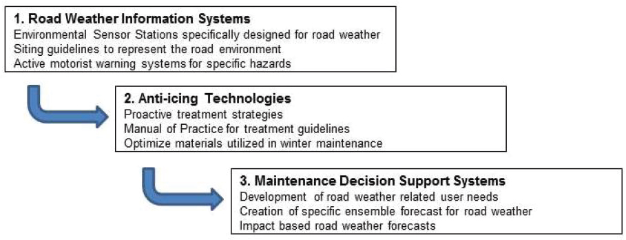
- The first involved the creation of road weather observational networks along the roadways by state DOTs. In the early 1990s, the Strategic Highway Research Program initiated a project (Boselly et al., 1993) to evaluate ways to fill in the gaps in the weather observation networks near roadways particularly where the National Oceanic and Atmospheric Administration (NOAA) observational networks are quite sparse. This project laid the groundwork for many states to begin installing environmental sensor suites that included not only routine atmospheric sensors, but also sensors to measure pavement surface temperature, electrical conductivity of moisture on the pavement to determine the amount of deicing chemicals present on the pavement, subsurface temperature probes, and most recently, optical sensors that provide estimates of surface friction. The aggregation of these environmental sensor stations into a Road Weather Information System (RWIS) allows state DOTs to utilize proactive strategies to mitigate the effects of adverse weather on roadways. The FHWA provided guidance (Manfredi et al., 2008) to help standardize installation, and provided leadership for state DOTs to aggregate these RWIS observations in a national database for operational and academic use (NCEP Central Operations, 2016). Today there are more than 2,400 RWIS sites throughout the United States in every state.1
- The second technology resulted from a desire to emulate European proactive winter maintenance strategies. Anti-icing and the use of liquid deicing chemicals were made possible through the use of pavement temperature forecasts based on RWIS road weather data (Blackburn et al., 1994). FHWA built on this work with a project conducted by the U.S. Army Corps of Engineers Cold Regions Laboratory (Ketcham et al., 1998) that yielded the “Manual of Practice for an Effective Anti-icing Program” (Ketcham et al., 1996). The manual includes charts of suggested winter maintenance responses based on the road weather forecast and pavement temperature trends.
- The final initiative that ties these developments together was the creation of a Maintenance Decision Support System (MDSS) to help maintenance managers evaluate their route-specific road weather and suggest optimal treatment strategies based on the Manual of Practice noted above. FHWA contracted with several groups2 to develop and demonstrate a working system that pri
___________________
1 A collection of RWIS data from state DOTs can be found here: https://ops.fhwa.dot.gov/weather/resources/links.htm. And a nationally compiled collection can be found here: https://madis-data.ncep.noaa.gov/MadisSurface (clicking on the “Datasets” button opens a window with everything selected; de-select the top datasets box, scroll down and select “RWIS”).
2 The National Center of Atmospheric Research was the lead agency along with the Cold Regions Research and Engineering Laboratory, Massachusetts Institute of Technology–Lincoln Laboratory, NOAA–Forecast Systems Laboratory (FSL), and National Severe Storms Laboratory (NSSL).
vate companies could then build on to create tailored MDSS products (NCAR Research Applications Laboratory, 2017). A key element of the MDSS is a high-resolution ensemble forecast utilizing meteorological elements important to road weather—in particular for determining the pavement temperatures, which are crucial to understanding how weather will affect the roadway.
Along with these advances in providing road weather data to state DOTs, there are likewise many advances occurring in the provision of warnings and information directly to motorists. For instance, the RWIS data is used in Intelligent Transportation System applications to provide motorists with real-time warnings of hazards such as high winds, icy roadways, avalanche, blowing dust and low-visibility conditions, and flooded roadways (see examples in Figure 4.4). Travelers can also receive information on road conditions prior to and during a trip from a multitude of other private and public sources, many of which rely on information provided by state DOTs. To provide a common framework for this traveler information, the Federal Communications Commission agreed to designate 511 as the nationwide traveler information number
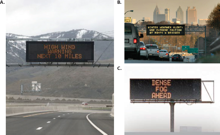
SOURCES: A: https://ops.fhwa.dot.gov/publications/fhwahop13013/ch1.htm; B: http://www.dot.ga.gov/AboutGeorgia/Pages/GDOTAnnouncementDetails.aspx?postID=38; C: http://www.dot.ca.gov/ctjournal/2009-2/Safety.html.
(FHWA, 2017a), and state DOTs developed traveler information systems to meet the 511 requirements, and to help ensure that drivers are alerted to hazardous conditions before they initiate their trip. While 511 is a nationwide telephone number for traveler information, each state system is independent, with little consistency between them. For example, the New England system reports road conditions in two broad categories3 while South Dakota utilizes 15 different categories to classify road conditions with a multitude of solid and dashed color combinations.4 Some agencies, like Iowa DOT, have incorporated real-time camera images taken from their snowplows to show the actual road conditions along with text descriptions. The lack of consistency in reporting between states has raised concern within DOT operations communities, but little has been done to determine the best classifications and representations that appropriately convey the impact and risk posed during adverse weather.
Further complicating this picture is the emerging role of crowd-sourced data in providing information about road hazards (FHWA, 2014). Citizen reporting is seen as a growing opportunity to provide information on road hazards and risk, particularly regarding adverse weather. In addition to widely used mobile apps such as Waze, the Utah DOT developed its own smart phone application to facilitate the collection of this information (Neugebauer, 2014), which has thus far seen wide acceptance by motorists and 99% accuracy in reporting. SBS research can provide important insights about the value travelers place on the many different sources of road condition reporting systems they utilize before and during a trip. Understanding why travelers value one source over another would help agencies focus limited resources on the most effective delivery methods.
A Strategic Highway Research Program project on the Effectiveness of Different Approaches to Disseminating Traveler Information on Travel Time Reliability (Kuhn et al., 2014) examined the human factors associated with communicating traveler information to drivers. The study recognized the importance of the variety of media, including personal navigation devices (e.g., GPS enabled mobile devices, smart phone applications) and crowd-sourced applications to convey traveler information. The study also emphasized that the safety implications of distracted driving and the increasing complexity of warning information being provided to drivers heightens the urgency of understanding the relationships between the information and receiver. Similar points were called out during an AMS Policy Forum on “Weather and Highways” (AMS, 2004). Despite the many advances taking place with technologies to connect vehicles with roadside infrastructure and with other vehicles, successful communication of informa-
___________________
3 See http://www.newengland511.org for details.
4 See http://www.safetravelusa.com/sd for details.
tion on road weather and adverse impacts will still depend on the driver’s ability to understand the risks and the implications of warnings for their own personal context, and to make sound decisions regarding their travel.
In 2008 FHWA initiated the project Human Factors Analysis of Road Weather Advisory and Control Information (Richard et al., 2010) to better understand traveler needs for information before and during trips and to identify the most effective methods for communicating road weather information with drivers. Weather information requirements and different delivery methods were determined for several travel scenarios, and a guide was developed for state DOTs to help standardize communications. Further research is needed to assess if the messages and communication modes in the guide actually influence traveler decisions and to explore questions such as the following:
- With all the advances taking place in road weather data collection, active warning systems, more accurate road weather forecasts and traveler information, and message delivery through numerous forms of media, why have the numbers of injuries and deaths not decreased more?
- How do travelers get road weather information and what influences their travel decisions?
- How effective are in-vehicle communications about weather impacts on the roadways?
- What are most effective ways to communicate complex situational awareness and risk regarding road weather impacts to travelers?
4.3 KEY PARTNERSHIPS AND INTERACTIONS IN THE USE OF ROAD WEATHER INFORMATION
During adverse weather conditions, the transportation network provides an important lifeline in the provision of critical community services. Maintaining mobility is critical to the mission of emergency managers and responders, and to the provision of essential functions before, during, and after adverse weather events. The decisions and actions taken by the state DOTs and by travelers can affect the transportation system just as much as the direct impacts of adverse weather. For example, if a crash occurs due to slippery conditions, the resulting congestion caused by the crash and the emergency response vehicles can prevent snowplows from applying treatments, which in turn allows more pavement to remain in a slippery condition.
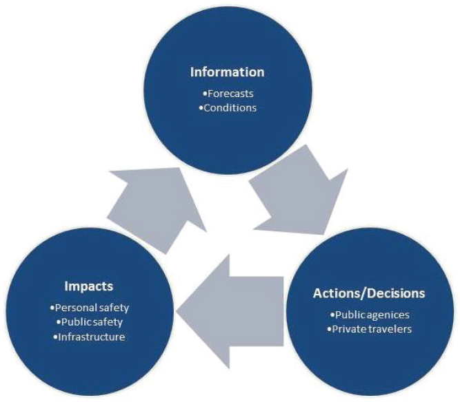
There are numerous sources of weather and impact information sources available to both travelers and public officials who must prepare and implement mitigation strate-
gies for adverse weather events. There is seldom perfect consistency among different forecasts, and thus operations and emergency managers must evaluate these various sources of information and make appropriate decisions about what response actions to initiate. These decisions and actions will in turn cause impacts on the system (see Figure 4.5). The success of the response is not only dependent on the atmospheric science behind the forecasts, but on an array of human factors and interactions between players. While much still needs to be learned about travelers’ motivations and decisions about traveling during adverse weather, one thing that is already well understood is that conflicting information about road conditions and impacts confuses the process. Providing consistent, timely, accurate, impact-based, and actionable messages helps avoid confusion and helps travelers make more informed travel decisions.
It is also well understood that personal relationships between forecasters and highway operations managers are extremely important in translating atmospheric and road weather forecasts into mitigation strategies to maintain mobility. During the early development of the MDSS, a series of workshops brought together weather forecasters and highway maintenance managers to discuss what weather
information is needed by operational maintenance managers (e.g., forecast detail, resolution, timing) and what products could feasibly be produced by forecasters (FHWA, 1999). They discovered that both sides had preconceived and often inaccurate ideas regarding what the highway agencies required and what the atmospheric science could produce. The development of effective relationships between forecasters and maintenance managers was key to the initial success of the MDSS project, but these relationships existed among only a few select forecasters and highway maintenance managers, and these have proven to be difficult to maintain and expand on. Programs to understand and improve these relationships are necessary in order to see the full benefit of the atmospheric science translate into actionable strategies by highway agencies.
This experience points to other important questions that SBS research can help elucidate, such as:
- How can the NWS Weather Forecast Offices (WFOs), private meteorological companies, and maintenance managers continue to develop fruitful working relationships?
- What are the organizational cultural barriers that impact the relationship between forecasters and maintenance managers? What are the trade-offs among timing, accuracy, and confidence that affect operational response and trust in the forecast by maintenance managers?
- Why do some operational personnel such as maintenance managers continue to distrust forecasts that are based on sound science?
In conclusion, we emphasize that the nation’s economy and essentially all aspects of society are grounded in our ability to move from point A to point B. There is no other activity that increases the risk of injury or death during adverse weather more than choosing to get in a vehicle and attempting to travel. Doing so can have major consequences not only for the individual traveler, but for many others as well. Applying SBS expertise to studies of road weather offers the potential for profound impacts in terms of reducing death and injury, and improving the many complex interactions that occur among public transportation agencies, private organizations, and individual travelers in efforts to prepare for, mitigate, and respond to dangerous weather events.


