Tactile Wayfinding in Transportation Settings for Travelers Who Are Blind or Visually Impaired: Volume 1: Conduct of Research (2025)
Chapter: 6 Experiment 3: Using and Navigating TWSIs in a Natural Environment
CHAPTER 6
Experiment 3: Using and Navigating TWSIs in a Natural Environment
The third experiment was executed with the goal of evaluating the effectiveness of TWSIs in natural environments. Field tests were conducted in Charlotte, NC. The city was selected based on evidence that there was good cooperation among municipal planning, public works, and transit agencies, and the fact that there was likely a sufficient number of blind individuals to form an adequate pool of eligible participants. Further, Charlotte offered a variety of test sites that pose wayfinding challenges as they currently exist, and where TWSIs could be installed to investigate if their use improved wayfinding performance. The trials tested blind pedestrians’ ability to use TWSIs to find and align for street crossings, cross large open spaces to specific destinations, and navigate to destinations in different transit facilities.
The intent of experiment 3 was to enhance understanding of the findings from experiments 1 and 2, and to validate the results from those controlled-setting experiments, combined with other results identified in the literature review, by testing arrangements of TWSI systems in the real world. Blind or visually impaired individuals were asked to travel routes that required them to navigate complex outdoor environments to reach destinations, and to locate crossings and transit door opening locations.
Setting
Charlotte was identified as a test location that met the research design needs. The city offers a mix of challenging environments close to one another where there may be insufficient wayfinding cues for pedestrians with vision disabilities, including bus, light rail, and streetcar facilities; hard-to-find crosswalks lacking good information for establishing a heading for street crossing; and open plazas. The research team collaborated with the municipality to discuss sites and performed a desk review of facilities and routes using Google Maps aerial and street views. Team members visited Charlotte to scout the viability of specific locations and began to develop routes, route plans, and data collection instruments tailored to the selected sites. In general, the goal in site selection and trial design was to produce results likely to be generalizable to facility types not specifically covered in the field testing.
TWSIs Tested
Three different TWSIs were temporarily installed across 11 locations. Where DWSs were installed, the team used the DWS-2 geometry from experiments 1 and 2. Likewise, the geometry of TDI-1 was used wherever bars were installed (see Table 2 in Chapter 4 for dimensions). Given the quantity of material needed, either the polymer panels from the controlled-setting experiments were reused or rubber mat panels were used. The bars for the rubber mat TDIs were made of hard plastic material adhered to the rubber mat base in the same geometry as TDI-1.
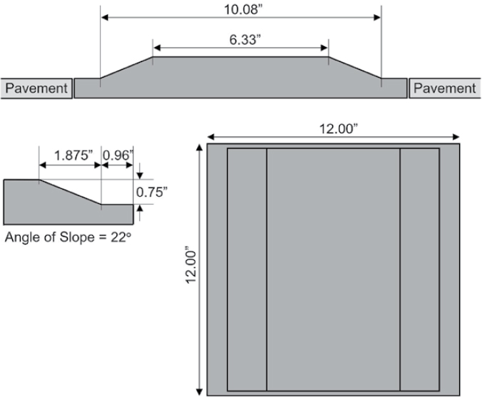
Note: A series of drawings showing profile views on the top and left and a plan view on the bottom right of a 12 × 12 in. (304.8 × 304.8 mm) panel of TWD. Dimensions are given in inches.
Figure 10. Example of TWD Dimensions showing the trapezoidal shape of this delineator.
The third TWSI used was a tactile warning delineator (TWD) made with hard rubber panels 13 in. (0.3 m) wide, 45 in. (1.1 m) long, and 0.75 in. (19 mm) high with gradually sloped edges from the bottom of the panel to the flat top, creating the trapezoidal cross-sectional shape (see Figure 10 for a similarly dimensioned example of the TWD geometry). The material used as the TWD in the experiment was a product sold on the market as portable rumble strips, and while the geometry was not the same as was tested previously by Bentzen, Scott, and Myers (2020), it was quite similar. The design of the product allowed for the temporary installation needed for the study.
All materials were taped onto the substrate walking surfaces where tested except for the TWD, which was heavy enough to remain in place with no slippage without the need to affix it to the pavement. Substrate surfaces varied in pavement type from brick and tile pavers to concrete. Given the variability in condition of the substrate pavements at each site, minor height differences between the polymer TDI panels and the rubber mat TDIs were negligible.
TWSI Configurations by Test Site and Task
The test sites selected in Charlotte represent a diversity in the potential challenges blind people face when navigating these and similar types of settings. The research sites across the course were (see Figure 11 for locations):
- Light rail boarding platform (south side) where it is unclear where the doors open to board
- Pedestrian crossing of light rail lines where accessible cues do not exist to locate the opening to the crossing location
- Light rail boarding platform (north side) where it is unclear where the doors open to board
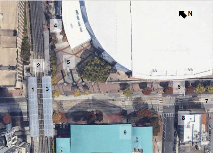
Figure 11. Satellite imagery view of test course identifying each site location. Site numbers correspond to the location for each Task description explained further in the text below.
- Open (upper) plaza area to travel through with potentially confusing features or lack of information
- Open (lower) plaza area to travel through with potentially confusing features or lack of information
- Midblock pedestrian crossing where there are minimal/insufficient cues to locate the crosswalk
- Streetcar boarding platform where it is unclear where the doors open to board
- Skewed intersection where other cues may lead to establishing an incorrect alignment to cross and mislead a traveler outside the crosswalk
- Bus loading area where it is unclear where the door opens to board
The configuration of TWSIs used at each site is described below in the order they were encountered by participants along the test route.
Task 1. Epicentre to CTC/Arena Lynx North-Side Boarding Location
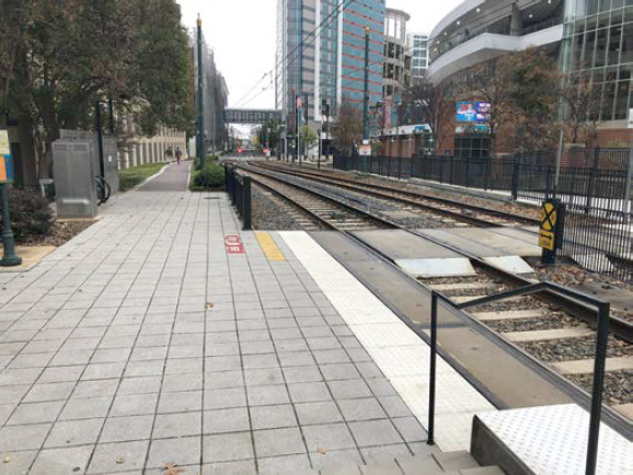
Participants were positioned to start at the Epicentre shopping center and instructed to go down the ramp that connects the Epicentre to the light rail station, find the platform edge marked with domes, turn left, and find the raised bars that marked where the doors open for the train. The long-sloping concrete ramp was bounded by railings on each side of the ramp along with a handrail running down the middle (Figure 12, left). The transit platform edge was marked by an existing DWS that ran the length of the platform. The platform surface consisted of square brick-like pavers with minor beveling at the edges, which created a somewhat rough surface (Figure 12, right).
A locator TDI (transit door location bars) was installed near the far end of the platform to simulate the location where a train car door would open. This TDI used polymer panels laid out to form a 2 × 8 ft (0.6 × 2.4 m) TDI with the bars oriented parallel to participants’ direction of travel on approach (Figure 13). Once found, participants were to turn right (toward the platform
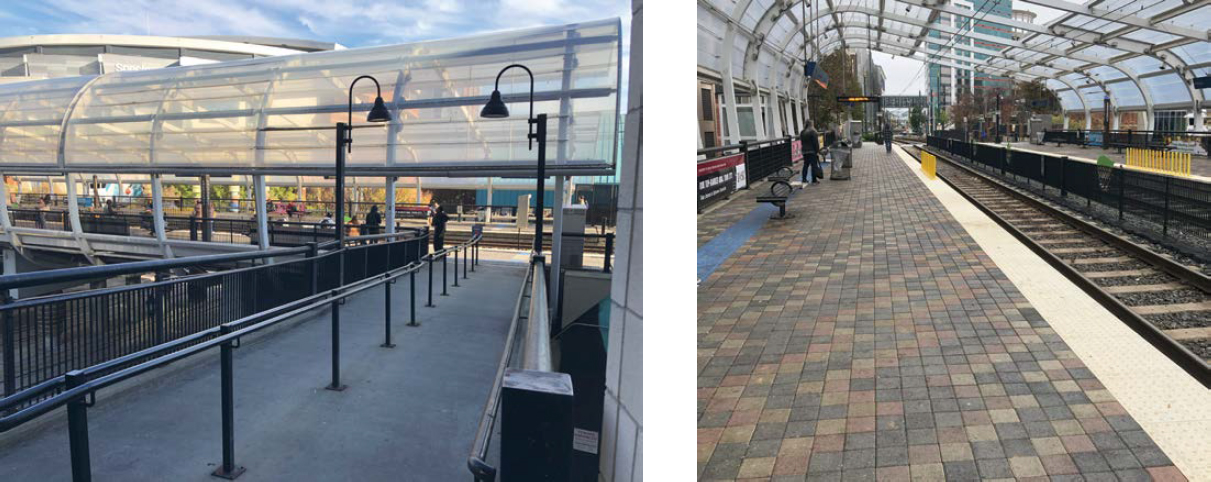
Figure 12. Photo from Epicentre looking down the rampway to the Lynx Station (left); photo of transit platform (right).
edge) and follow the transit door location bars with the bars perpendicular underfoot, stop at the DWS, align to board, and then indicate they were prepared to board.
Task 2. CTC/Arena Lynx North-Side Platform to Rail Crossing
Participants started near the TDI transit door location bars on the north-side platform with the platform edge on their right and were told to go down the stairs and find the crosswalk marked with bars to cross the rail lines. As participants traveled off the boarding platform and
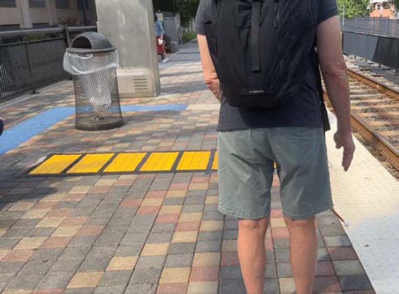
Figure 13. Photo of TDI on transit platform indicating where the train car door opens. The TDI transit door location bars tee into the DWS marking the platform edge.
down the stairs, the pavement transitioned to square concrete pavers. The stairs were bounded by a handrail (Figure 14).
Given the lack of a vertical barrier to prohibit blind people from inadvertently attempting to cross the tracks between the end of the stairs and the opening for the pedestrian crossing, a 16-ft-long (4.9 m) TWD was installed to create a boundary that ran along the existing DWS on the side away from the tracks. Along the width of the pedestrian crossing opening, an additional 10 × 1 ft (3 m × 30.5 cm) of DWS was installed so there was no gap between the end of the TWD and the existing DWS to ensure a continuous edge treatment.
The centerline of the crossing was marked by 2-ft-wide (0.6 m) TDI sidewalk alert bars that ran the width of the sidewalk, approximately 8 ft (2.4 m), and ended flush with the temporarily installed DWS. This alert TDI used the rubber mat material with the bars oriented parallel to the participant’s direction of travel on approach (Figure 15). Once found, participants were to turn right (toward the rail lines) and follow the sidewalk alert bars with the bars perpendicular underfoot, stop at the DWS, align to cross, and then indicate they were prepared to cross.
Task 3. Rail Crossing to South-Side Platform Boarding Location
Participants started this task by using the pedestrian crossing to the rail lines after a COMS indicated it was safe to cross. They were instructed to cross and then find the raised bars marking the door-opening location for the train on the south-side platform. This route called on participants to complete a series of tasks: (1) detect and identify the DWS on the far side to understand they completed the crossing; (2) turn right and potentially follow the DWS and TWD to the ramp leading up to the platform; and (3) find, detect, identify, and use the TDI transit door location bars on the south-side platform to align to board the train.
Note: An existing DWS continue along the side of the walkway from the bottom of the stairs to a fence that delineates the edge of the walkway and prohibits people from crossing the tracks at an unsafe location. The DWS continues to mark the boundary between the pedestrian zone and the railway where the pedestrian crossing is located. There is no vertical barrier after the stair handrail and before the designated crossing location to discourage pedestrians from crossing onto the railway on the tracks prematurely.
Figure 14. Photo from the transit boarding platform looking toward the pedestrian crossing of the rail lines.
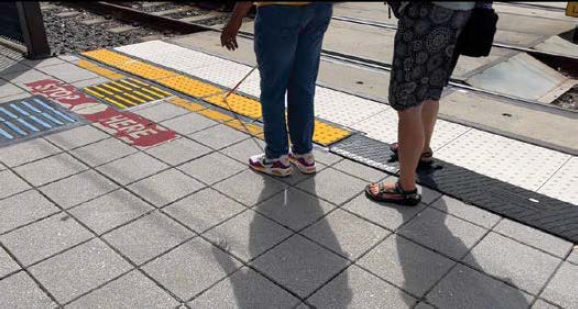
Note: The COMS is walking behind the participant with one foot on the installed TWD, ready to intervene if necessary.
Figure 15. Photo showing a participant interacting with the temporarily installed DWS as she approaches the sidewalk alert TDI bars that mark the location of the pedestrian crossing across the rail lines.
The south side of the pedestrian crossing is largely symmetrical to the north side except for a ramp connecting the platform to the walkway along the rail line in lieu of stairs. Therefore, the temporarily installed TWD and DWS mirror those installed on the north side: the DWS ran across the width of the pedestrian crossing; the TWD marked the boundary between the end of the DWS and the ramp’s handrail to indicate a location not to be crossed. TDI sidewalk alert bars were also installed to mark the location of the pedestrian crossing.
On the south-side transit platform at the CTC/Arena Lynx station, polymer panels of TDI were installed to form a 2-ft-wide (0.6 m) locator path that ended flush with the existing DWS along the platform edge and ran back 3 ft (0.9 m) across the transit platform. The bars were oriented parallel to the direction of approaching travelers such that when they turned toward the platform edge, the bars would be perpendicular underfoot for alignment to board (Figure 16).

Figure 16. A shorter length of TDI transit door location bars installed on the south-side platform to mark where the train doors open.
Task 4. CTC/Arena Lynx Station to Hornets Fan Store (Upper Plaza)
Participants were led back down the ramp from the south-side transit platform (with the rail lines on their left) to a starting location a few feet upstream from the pedestrian crossing to cross the tracks. They were told to travel down the walkway away from the station, find the bars, follow them to a choice point, and then turn left to find the ramp up to the Hornets Fan Shop. Near the end of the walkway to the upper plaza area of the Spectrum Center where the Fan Shop is, the pavement transitions from the square concrete pavers to variations of brick-patterned pavers and concrete.
The wide walkway from the transit station is bounded on either side with a handrail and a low wall as it slopes down toward the plaza. As the walkway opens onto the upper plaza, the wall separating the railway from the pedestrian way becomes a retaining wall that turns 90 degrees away from the rail lines and then 90 degrees back, creating a dead-end corner at the end of the walkway that channels people toward the plaza (Figure 17).
One 1-ft-wide (0.3 m) strip of polymer panels of TDI with the bars oriented parallel to the direction of travel was installed in the middle of the walkway and starting about 15 ft (4.6 m) from the turn in the retaining wall. The TDI path then turned 90 degrees and continued toward the plaza for another 26 ft (7.9 m) to a CPI. The choice point was defined as a 3-ft-square (0.9 m) blank space with no TWSI. To the left at the choice point, another TDI path 1 ft (0.3 m) wide and 16 ft (4.9 m) long was installed leading to the ramp up to the Hornets Fan Shop; to the right, a 10-ft-long (3 m) TDI path was installed leading to the top of the stairs going to the lower plaza (Figure 18).
Task 5. Hornets Fan Shop to Spectrum Center Main Entrance (Upper to Lower Plaza)
Participants started this task with the ramp to the Fan Shop entrance behind them. They were instructed to follow the strip of bars in front of them, going straight through the choice point to find the stairs; go down the stairs and follow the bars at the bottom of the stairs to another choice point; and turn left to reach the main entrance to the Spectrum Center. For the first part of this route, the same TDI paths on the upper plaza were used. Once participants returned to the choice
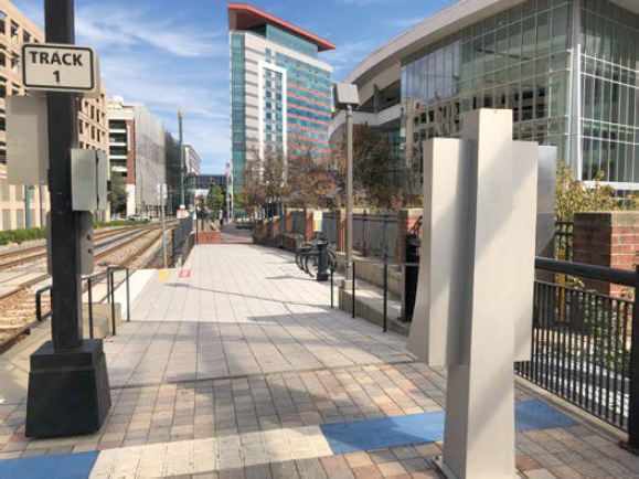
Figure 17. Photo of walkway leading away from the CTC/Arena Lynx transit station and toward the upper plaza of the Spectrum Center.
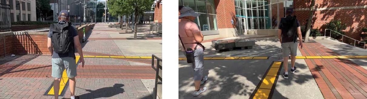
Figure 18. Photo of TDI path at the end of the walkway as it opens onto the plaza showing the 90-degree turn in the path (left); photo of the 3 TDI paths on the upper plaza intersecting at a CPI defined as a blank or empty space at the junction of paths (right).
point, they had to find the TDI path in front of them to continue straight to the railing at the top of the stairs. The COMS verbally guided participants down three sets of stairs split by landings between each until they reached the landing above the final set of stairs.
A 3-point junction of TDI paths was created on the lower plaza, comprising one leg of the TDI path running from the stairs to the choice point (indicated by a 3-ft-square [0.9 m] blank space at the junction), another leg running toward the Spectrum Center entrance, and a third leg running toward the sidewalk that runs adjacent to the arena. The TDI approaching from the stairs ran 44 ft (13.4 m) straight, then turned to the left 45 degrees and continued 14 more ft (4.3 m) to the choice point. From the choice point, participants would need to find and then follow the leg approximately 45 degrees to the left of the TDI path from the stairs. This TDI path continued 18 ft (5.5 m) before ending near the Spectrum Center entrance. The third TDI path picked up roughly across from the leg approaching from the stairs and was 14 ft (4.3 m) in length (Figure 19).
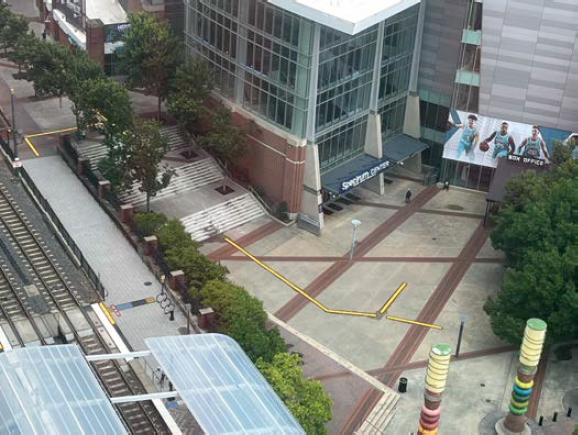
Figure 19. View from above the course showing the TWSIs installed on the south side of the pedestrian rail crossing, the TDI paths on the upper plaza, and the TDI paths on the lower plaza.
Task 6. East Trade Street to Midblock Crossing Location (Access to Gold Line Streetcar Platform)
Participants were led to a starting point on the sidewalk along East Trade Street such that the street was parallel to them on the right. They were instructed to walk down the street, find the bars marking the second midblock crossing location to access the Gold Line Streetcar platform, turn and follow the bars, and align to cross. The sidewalk was made of brick pavers and was approximately 30 ft (9 m) wide, with a hardscaped furniture zone near the curbline that contained a series of street trees, light posts, and other amenities.
The Gold Line Streetcar runs along two different tracks down the middle of East Trade Street. There are two median transit platforms or islands on East Trade Street: the northern island serves northbound streetcar riders and the southern island serves southbound streetcar riders. While South Brevard Street tees into East Trade Street in between the two platforms, allowing pedestrians from the southwest side of East Trade Street access to either platform from the intersection corners, the crosswalks from the northeastern side of East Trade Street to the islands essentially function as midblock crosswalks (see Figure 20).
Two sets of rubber mat TDIs were installed across the sidewalk to serve as sidewalk alert bars for crossing locations to the two boarding platforms. The first alert TDI was installed to mark the crosswalk location to the northbound platform. The second alert TDI marked the crosswalk location to access the southbound platform or to continue across to the southeast corner of South Brevard Street. Each set of sidewalk alert bars was 2 ft (0.6 m) wide by 28 ft (8.5 m) long and oriented with the bars parallel to the direction of approaching travelers walking along the sidewalk and perpendicular underfoot as travelers turned to follow them toward the street and align to cross. The sidewalk alert bars ended flush with the DWS marking the crossing location and adjacent to the accessible pedestrian signal (APS) pedestal (see Figure 21).
Task 7. Cross to Gold Line Streetcar Platform and Find Boarding Location
Participants began this task at the same location where they ended Task 6: waiting to cross the northbound lanes of East Trade Street. They were instructed to cross to the boarding platform, turn left, find the raised bars that marked where the doors open to board the streetcar, and align to board. The transit platform was approximately 10 ft (3 m) wide with DWSs marking each edge of the street crossing through a curb cut at one end of the median. The left image in Figure 22 shows the ramp up from the curb cut that led to the platform with DWSs delineating the boarding edge and a railing blocking off the remaining sides. A narrow shelter with a bench sat at the back of the platform such that the effective width of the pedestrian accessible route along the ramp and platform varied from 4 to 6 ft (1.2 to 1.8 m). The pavement for the platform was concrete.
At the far end of the platform from the street crossing curb cut, a locator TDI 2 × 3 ft (0.6 × 0.9 m) was installed flush with the back edge of the DWS along the platform edge to mark where the doors opened to the streetcar (Figure 22, right). The TDI material installed here was polymer panels.
Task 8. Cross from Gold Line Streetcar Platform and Prepare to Cross Brevard Street (Alignment Square)
Participants were led back down the ramp from the platform to the DWS at the curb cut in the median marking the transition between the transit island and southbound travel lanes on
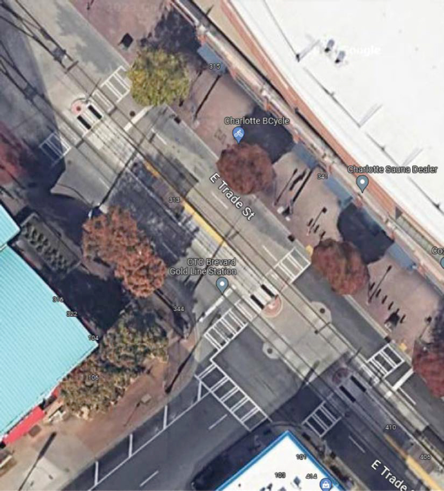
Figure 20. Aerial image depicting the two median islands that serve as streetcar boarding platforms along East Trade Street where South Brevard Street tees into it.

Figure 21. Photo looking along East Trade Street with sidewalk alert bars across the width of the sidewalk and ending at the DWS for the midblock crossing to the southbound streetcar platform.
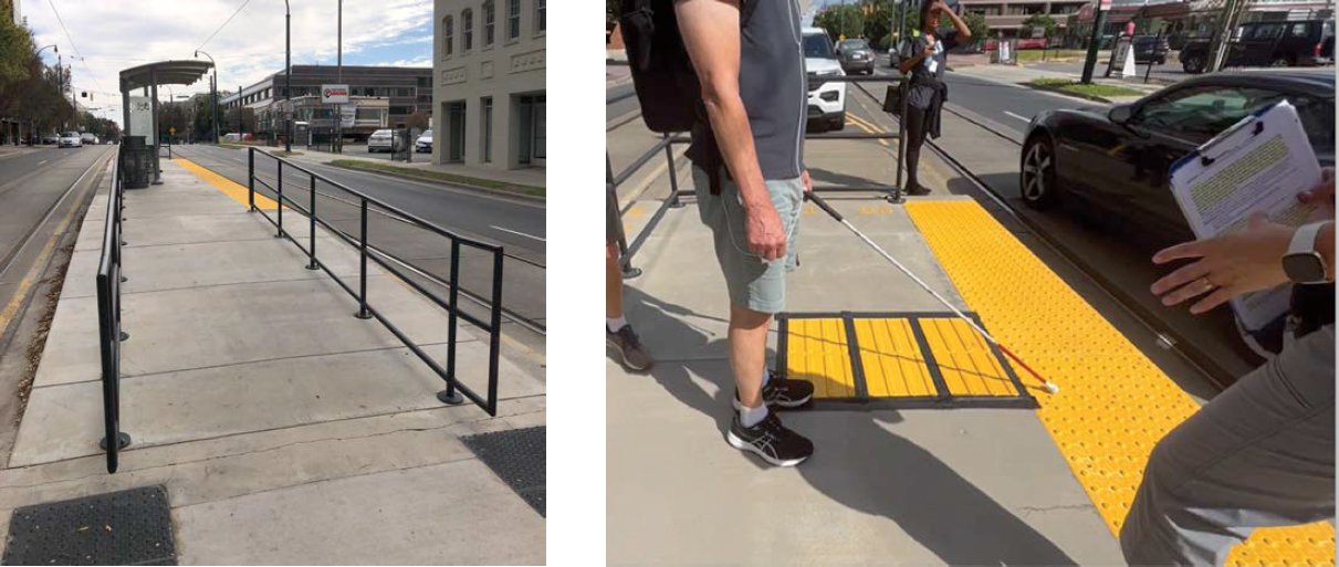
Figure 22. Looking up the ramp to the streetcar platform (left); the locator TDI installed at the far end of the platform to mark the door-opening location (right).
East Trade Street. They were then instructed to cross East Trade Street and turn right to prepare to cross Brevard Street using the alignment square. This particular crossing is slightly skewed such that the curb ramp leads toward the middle of the intersection. The COMS activated the APS on the transit island and ensured participants began crossing East Trade Street when traffic was stopped.
Participants had to complete the crossing to the southeast corner of East Trade and South Brevard Streets, turn right, find the location to cross Brevard Street, and then find the alignment square and use it to align to cross. Both street crossings from the corner contained ramps with existing DWSs and separate mountings for each APS.
The alignment square was made from the rubber mat TDI installed as a 2 × 2 ft (61 × 61 cm) square on the ramp flare farthest from the intersection, as shown in Figure 23.
Task 9. Brevard Street Crossing to Charlotte Transportation Center and Bus Bay U
For the final task, participants were instructed to cross South Brevard Street, travel down the sidewalk along East Trade Street (now heading north) until they reached the driveway to the Charlotte Transportation Center (CTC), and turn left to enter the CTC and find the bars marking the bus boarding location at the first bus bay. The sidewalk along East Trade Street was made of brick pavers with street trees and other vertical objects running along the curbline furniture zone and low planter boxes delineating the other edge of the sidewalk except for two openings to stairs leading to the buildings set at a lower elevation.
The transition to the CTC driveway was marked by a curb ramp with a DWS. Rounding the corner into the CTC, the pavement changes to concrete. The sidewalk inside the CTC was approximately 9 ft (2.7 m) wide from the curb to some temporary fencing on the other side. The TDI transit door location bars installed were a 2 × 3 ft (0.6 × 0.9 m) section of polymer panels placed at the curb edge (Figure 24).
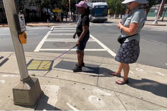
Note: This figure shows a participant standing on the DWS at the bottom of the ramp to cross South Brevard Street while finding the TDI alignment square with their long cane. The alignment square is to the left of the DWS on the ramp flare and oriented so the bars are perpendicular to the direction of travel needed to cross the street in the crosswalk to the far corner. The COMS stands behind the participant observing and ready to intervene if needed.
Figure 23. Photo of crosswalk across South Brevard Street looking from southwest corner of East Trade Street and South Brevard Street.

Figure 24. Photo of participant searching with their long cane for the locator TDI installed to mark where the bus doors open.
Procedure
Before beginning, the COMS introduced participants to the different surface patterns they might encounter. Familiarization took place in a roped-off area of a nearby parking deck where TWSIs were laid out so participants could briefly learn about what each surface was, how it felt, and how they might be instructed to use them during the trials in the field (Figure 25). Generally, this familiarization and training lasted 30 to 45 minutes. This should be understood as very minimal training and practice given the number of TWSI materials and uses that were introduced, specifically, TDI guide path following; following TDI paths that turn; detecting choice-point indicators at path intersections; understanding path intersections and finding and
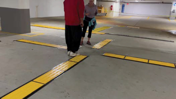
Figure 25. Photo of participant in the parking garage getting familiar with the different types of TWSIs and tasks they will be asked to do before going out on the course.
following a desired path away from the intersection; detecting DWSs at a platform edge; finding and using TDIs for boarding locations and hard-to-locate crossing locations; locating and using a TDI alignment square at a skewed crossing; and detecting, identifying, and correctly using TWDs. Platform edges and crossings were simulated since the training was in the parking garage.
Once on the field course, participants traveled the test route individually, accompanied by the COMS, who intervened only for safety reasons or if a participant became disoriented and was not able to independently return to the intended route after making some attempts. The COMS also guided participants from one starting location to the next and gave instructions for each task. A data collector followed and recorded directly observed data. Depending on the task, participants were instructed:
- Find the raised bars that mark where doors will open.
- Find the pedestrian rail crossing marked by a strip of bars across the walkway.
- Find and follow the bars to a choice point, go the instructed direction (twice to turn left, once to go straight), and continue to a destination.
- Find the second set of bars marking the midblock crossing. Use the bars to align and cross to the boarding island.
- Find the crosswalk to cross from the boarding island to the corner; use the alignment square of bars to align to cross; turn right and cross the perpendicular street.
- Enter the bus transit center and find the bars where the doors will open for buses loading in the first bay.
Specific instructions for each task conveyed additional information based on the context of the site so participants could use typical cues for wayfinding, such as ramp railings, platform edges, street traffic or rail line sounds, or other features in the built environment to help them orient while traveling from the starting location to the end destination for the given task. In other words, the entire route from start to end was not marked with TDIs; rather, participants used their skills to navigate segments or turns where other features reliably existed to provide such wayfinding information.
Data Collected
A second researcher observed and recorded observable behavioral data throughout each task, collecting data about relevant participant behaviors including contact and interactions with TWSIs, effectiveness of TWSI use, whether tasks were completed successfully, the nature of any
errors, and the occurrence and reasons for any COMS interventions. Semistructured interviews were conducted with each participant after all their trials to seek a deeper understanding of their experience (see Appendix C for a few sample components of the data collection form used to record observations).
Analysis and Results
For Experiment 3, 17 participants who self-reported being unable to ever see crosswalk lines, curbs, or poles completed the session using a long cane. Participants ranged in age from 27 to 72 with an average age of 50. Nine of the participants were male (53%). Two participants used a guide dog as their primary travel aid, and all participants had been traveling independently for at least 2 years, with an average of 20 years of independent travel experience among them.
The results for the field study (Experiment 3) are presented in an entirely descriptive manner; there are no inferential statistical analyses. The goal of the field study was to evaluate participants’ ability to use the TWSIs in many ways and for many purposes with only a small amount of training and when installed in a natural, active, real-world environment. The goal was not to compare various designs or materials, as the designs employed in the field study were selected based on the results of prior experiments, including Experiments 1 and 2 of this project.
Detecting and Using DWSs as a Warning at Platform Edges and Street Crossings
Twenty-four in. (0.6 m) of existing depth of DWS were present at all elevated platform edges, at the bottoms of curb ramps, at the street-level access points to the streetcar median island, and at the boundary of the at-grade rail crossing, as is required. At the rail crossing, an additional 12 in. (0.3 m) of DWS were added due to the overall layout of new TWSI installations, not because there was reason to believe additional DWS depth was necessary. The necessity of such warnings at these locations was not being evaluated; however, it is possible that the introduction of additional TWSIs in areas near or adjacent to the DWS could in some manner interfere with the detection or identification and use of the DWS. There is no evidence from the field research to suggest that introducing additional TWSIs created such problems. There were no instances where participants were observed to approach a platform edge without detecting its presence (Tasks 1, 2, 3, and 7), no instances of participants crossing the DWS at the rail crossing prior to announcing that they were at the crossing (Task 2), and only one instance (out of Tasks 5 and 6) of a participant stepping past a DWS on a curb ramp and into the street prior to establishing and announcing a crossing start position (Task 6).
Detecting and Using TDIs at Transit Boarding and Street/Rail Crossing Locations
Throughout the experiment, participants were to use TDIs to find transit boarding locations, a difficult-to-identify rail crossing location, and a midblock crossing location. In Task 6, participants also needed to detect and identify the presence of such a TDI and then not use it (i.e., to find the second crosswalk location marked with a TDI along East Trade Street required knowing that they had crossed the first). In all these cases, the TDI was 24 in. (0.6 m) deep in the direction of participants’ approach/travel, with the bars oriented largely parallel to their direction of approach. The length of locator TDIs extended various distances from the curb, platform edge DWS, rail crossing DWS, or curb ramp DWS across the various platforms or walkways. When used for these purposes, the bars were always perpendicular to the direction needed to board a transit vehicle or make a street or rail crossing.
When contacted, detection and identification of TDIs for the purpose of marking boarding and crossing locations was excellent, as was subsequent use of the TDI to prepare to board or
to cross. When considering all tasks in Table 8 combined, once participants contacted the TDI for the first time, they stopped and moved onto the TDI 90% of the time, and they subsequently ended their trials on the TDI and well aligned on 85% of trials. When considering only the trials where participants ended the trial standing on the TDI, participants were well aligned 94% of the time. The detectability, identifiability (including the ability to differentiate it from other TWSI materials that were present), and usability of TDI for these purposes and in these environments and contexts was excellent once contacted.
The size of the installation relative to the dimensions of surrounding features did appear to affect the likelihood of being contacted. Where the locator TDI extended across the majority width of the platform/walkway/sidewalk, participants contacted the TDI the first time they reached the area where it was installed nearly 100% of the time (only one time did this not occur). Where the TDI was used to mark a transit boarding location and extended across the walkway/platform only 3 ft (0.9 m) from the curb or platform edge DWS, and where those walkways were approximately 8 ft (2.4 m) wide (Tasks 3 and 9), participants somewhat frequently walked along the walkway/platform past the TDI without contacting it; this happened on around 51% of such trials. When participants missed the TDI, the COMS eventually intervened to tell them they had gone past it, had them turn around, and then the participant independently tried again. Thus, the high rates of detection and use once contacted includes these trials where participants did not contact the TDI on their first pass along the walkway/platform but did after turning around and making another attempt to find the TDI.
There were several instances where the COMS had to intervene on the portions of tasks where participants were to find and use TDIs to locate and align at boarding or crossing locations. However, it is important to remember that these participants had varying levels of experience with independent travel and street crossings, had varying levels of knowledge about and experience with transit facilities (e.g., some were totally unfamiliar with the idea of a median streetcar platform), and had received minimal training and practice with the three types of TWSI and their many uses as employed in this research. For all the portions of tasks identified in Table 8, participants received at least one intervention on 45 of 135 trials (33.3%). Of those 45 trials, five included interventions for general orientation issues that were independent of any interactions
Table 8. Experiment 3 results: TDIs for marking boarding, street-crossing, and rail-crossing locations.
| Task and Type | Task 1: light rail boarding location | Task 2: rail crossing | Task 3: light rail boarding location | Task 6: midblock crossing | Task 7: streetcar boarding location | Task 8: skewed street crossing | Task 9: bus boarding location |
|---|---|---|---|---|---|---|---|
| TDI dimension (ft) | 2 × 8 | 2 × 10 | 2 × 3 | 2 × 28 | 2 × 3 | 2 × 2 | 2 × 3 |
| TDI extended across majority of walkway? | Yes | Yes | No | Yes | Yes | No | No |
| Contacted TDI on first pass down walkway | 100% | 94% | 59% | 100% | 100% | 88% | 38% |
| Moved onto TDI once contacted (first time) | 88% | 88% | 94% | 88% | 100% | 76% | 94% |
| Ended task on TDI and well aligned | 88% | 71% | 94% | 88% | 94% | 65% | 94% |
| When ended on TDI, well aligned | 88% | 86% | 100% | 100% | 100% | 87% | 100% |
| Finished task using TDI independently (no interventions) | 65% | 88% | 53% | 71% | 94% | 53% | 38% |
with TWSIs (e.g., having significant trouble heading reasonably straight down the platform or sidewalk and then becoming disoriented), and 18 were to tell participants they had gone past the TDI when they did not make contact with it (i.e., not a failure of detection or identification after having made contact with it). Participants in this latter case were allowed to turn around and independently attempt to find the TDI while heading back in the other direction, so their data is included when considering how they performed once they contacted the TDI for the first time. Thus, there were interventions on 17 of the 135 trials (13%) of the type shown in Table 8 that were specifically related to detecting, identifying, or using the TDI (e.g., the participant crossed the TDI without detecting it; the participant failed to follow the sidewalk alert bars toward the street to locate the curb ramp and DWS).
Detecting and Using a TDI Alignment Square at a Skewed Street Crossing
The data in Table 8 provides evidence that participants with vision disabilities were able to use bars oriented perpendicular to crossings or boarding directions very effectively to establish good initial alignment, and this same finding has been demonstrated in prior experimental testing outside this project. The 2 ft square (0.6 m) of TDI (alignment square) at one street crossing was located beside the DWS on the side of the curb ramp away from the parallel street, with the bars oriented perpendicular to the direction of the crossing. Only once did participants encounter an alignment square. In the context of the field research, where participants had to make use of various TWSIs employed in different ways in different contexts, they struggled a bit to effectively use the alignment square. The issue was not so much using the TDI for alignment once on the square, but finding the square, distinguishing it from the adjacent DWS, and/or making sense of how they were to use it in this context. Thirteen of 17 (76%) participants were successful in contacting the TDI alignment square and then independently moving onto the square to begin aligning and otherwise preparing to cross. Three participants first established their crossing alignment while on the DWS, suggesting possible confusion of the two surfaces. Unsurprisingly, given that truncated domes do not provide alignment information and that the long edge of the DWS tile was perpendicular to a direction facing into the intersection, the alignments participants established while on the DWS were very poor. One additional participant had a lot of difficulty making sense of the two surfaces; they contacted both, moved between the two multiple times, and became increasingly confused and disoriented. The trial was eventually ended by COMS intervention. Once on the TDI, whether participants reached this point independently or got there after an intervention, independent alignment was quite good, with 87% (13 of 15) establishing an alignment that if maintained during crossing would result in participants ending the crossing within the width of the crosswalk.
Following TDI Paths and Using Choice Point Indicators
Participants were observed to struggle with one particular aspect of the TDI path arrangement and path-following tasks, while otherwise being highly successful at following 12-in.-wide (0.6 m) TDI paths with a 4-bar arrangement and the bars parallel to the running direction of the path. The challenge occurred when first contacting and following the path after coming down the ramp from the light rail station and onto the upper plaza area where the TDI path was. The TDI path was installed leading straight away from the ramp from a position largely centered within the width of the ramp (see Figure 18, left). However, the ramp was around 15 ft (4.6 m) wide, and thus many participants entered the plaza area far enough to the left or right of the TDI path to not initially contact it with their cane. The arrangement largely ensured the participants would contact it eventually (and they did), and 82% of participants did begin following the path in one direction or the other after the first time they contacted it, suggesting it was detectable
and identifiable. However, the instructions were to find the path at the bottom of the ramp and follow it to the choice point. When participants first contacted the path at a position other than right at the bottom of the ramp, the instructions were ambiguous as to what direction they ought to go (left or right). Additionally, when followed from the segment at the bottom of the ramp, the TDI continued straight for 14 ft (4.3 m) and then turned 90 degrees to the right. Participants sometimes first encountered the path at or very near the turn, or otherwise encountered the turn soon after finding the path while still trying to decide if they were following the path in the correct direction. The result was a lot of confusion around this portion of the task, and the eventual need for many interventions to help get participants onto the TDI path and going in the correct direction, as well as many instances where participants eventually reestablished independent travel along the path at a point past the turn and headed toward the choice point. All this resulted in not having much in the way of “clean” data regarding how well participants would follow a path through a 90-degree turn, and highlighted the need for future consideration and research about how to ensure pedestrians with vision disabilities can initially get onto the starting point of a TDI guide path.
Once past the 90-degree turn and oriented toward the first choice point, participants did very well with all other TDI path-following tasks, which included navigating two separate lefthand turns at choice points, navigating through a choice point to continue straight, navigating along a path that turned 45 degrees, and detecting/finding the end of paths and available features when present. This required following a total of about 150 linear ft (45.7 m) of TDI paths. A summary of certain aspects of this performance is provided in Table 8. Participants perfectly followed straight segments of the path using whatever technique they chose (e.g., walking on the bars with both feet, walking with one foot on the bars and the other beside the bars, walking beside the bars while trailing/shorelining with their cane). Along path segments that did not have turns or intersections, participants followed the path without any significant deviations 100% of the time. Participants navigated the choice point on the upper plaza twice, once needing to turn left and once needing to go straight. Participants performed these tasks with a high degree of success (see Table 8).
On the lower plaza, participants had to follow the path through a 45-degree turn, and all participants were successful in making this turn, though they often did so after some exploration, with around a quarter of participants spending more than 10 seconds in the area near the turn. A lower percentage of participants were successful in making the left turn at the choice point on the lower plaza (65% were successful on their first attempt) than they were in making the left turn at the choice point on the upper plaza (88% were successful) or in going straight through the choice point on the upper plaza (100%). A combination of behavioral evidence and participant comments sheds light on this difference. The instructions for the path on the lower plaza were to find the path at the bottom of the stairs, follow it to the choice point, and to turn left at the choice point. It became evident that although the 45-degree turn was not a choice point (and thus no blank CPI), some participants thought that perhaps this was the left turn they had been instructed to make. When then arriving at the choice point, they went straight, thinking they had already completed the one turn they were to make. This raises some questions about effective directions as they relate to such paths, while suggesting that at least some instances of failing to make the turn at the choice point were not a product of failing to detect the CPI but resulted from the participant’s belief that they had already made the only turn they were to make.
When considering the four subtasks identified in Table 9, participants received interventions on 10% of trials (seven of 68 trials; 17 participants each attempting these four subtasks = 68 trials). Two of these interventions occurred when participants failed to make the turn at the path intersection on the upper plaza and five occurred after failing to turn at the intersection on the lower plaza.
Table 9. Field experiment results: Following TDI paths.
| Task and Type | Task 4: left turn at a choice point; to Fan Shop | Task 5: continuing straight at a choice point; to stairs | Task 5: continuing through a 45-degree nonintersection turn; to a choice point | Task 5: left turn at a choice point; to main entrance |
|---|---|---|---|---|
| Followed correct path away from intersection or turn on first attempt | 88% | 100% | 100% | 65% |
| Managed choice point or turn efficiently on successful attempts (less than 10 s approx.) | 93% | 100% | 76% | 91% |
| Detected end of path when reached first time (announced being at end) or found feature at end of path (e.g., handrail for stairs) | 82% | 100% | NA | 100% |
Using the TWD
For this research, the TWD was admittedly installed in a location where other vertical treatments would be more appropriate. Of the 26 linear ft (7.9 m) open to the rail lines along the walkway between the bottom of the stair handrail and the fencing that began at the far side of the pedestrian crossing, only 10 linear ft (3 m) were intended to serve the pedestrian rail crossing (see Figure 14). While DWSs ran this entire length, the remaining opening of 16 linear ft (4.9 m) between the near side of the rail crossing and the bottom of the stairs should have had a fence or railing as a vertical barrier to protect pedestrians from a rail-height drop from the walkway to the rail bed—it was not intended as an area to cross, nor is it an area where transit vehicles can be boarded.
In the absence of such a vertical barrier, a temporary TWD was added adjacent to the existing DWS to provide an additional warning. The trapezoidal TWD used for this temporary purpose has not been experimentally tested the way another TWD has been, is made of a different material, and has slightly different geometry than the previously tested TWD (Bentzen, Scott, and Myers 2020). Unlike the TDI and DWS on other tasks, where the TWD was present, there was nothing about the task that encouraged or required participants to contact and use the TWD. It was present to serve as a warning and boundary as participants made their way along the platform on one side of the light rail station in search of the rail crossing marked by TDI, and when subsequently traveling from the crossing up to the platform on the opposite side of the station. Thus, 17 participants had the opportunity to encounter the TWD at two distinct times while performing prescribed tasks, and there were thus 34 trials to be considered. Participants contacted the TWD on 22 of those trials, and they remained on the correct side of the TWD on 17 of those 22 trials (77%). However, on 5 of the 22 trials where a participant contacted the TWD (23%), they subsequently stepped up onto the TWD and began crossing to the other side of it, or appeared to be about to cross to the other side, requiring the COMS to intervene. No participant ever got onto the track side of the TWD without first contacting it with their cane and feet. The extent to which these failures to serve as an effective warning are attributable to TWDs broadly, or perhaps to the unique nature of this temporary TWD and/or the exact environmental context, remains unknown. A more complete barrier is likely more appropriate at the location where the TWD was tested, and in more likely applications of TWDs there would not be DWSs on the opposite side of the surface. Some of the participants who eventually crossed the TWD were observed exploring the DWS with their cane, and then seemed to be choosing to cross the TWD to reach the DWS at the edge, perhaps even thinking the DWS was there to mark the boundary between the pedestrian walkway and the rail lines at the crossing.
Experiment 3 Conclusion
Participants were given a significant number of tasks, and tasks that encouraged the use of three different types of TWSIs, with TDIs being used for multiple purposes and in somewhat distinct arrangements for different tasks. Additionally, these participants attempted all these tasks with only 35–45 minutes of familiarization, training, and practice. Except DWSs on platforms and curb ramps, most participants had limited prior experience with TWSIs being employed for these purposes, and participants had a range of experience with the environments and underlying tasks (e.g., light rail transit stations, midstreet transit platforms, street crossings). Given this, the experimental installations of TWSIs appear to have supported the completion of numerous ecologically valid tasks in real-world environments (e.g., find the pedestrian crossing to cross from one side of a station to the other, find a particular destination near a large open plaza area, find a midblock crosswalk and cross to a midstreet transit platform).
The field experiment did reveal at least a few areas needing additional consideration or research. First, where TDIs were used to mark boarding locations, participants were highly successful using them as intended once they were contacted. However, where the TDI did not extend across most of the platform/walkway/sidewalk, participants frequently failed to contact them when first navigating down the walkway. The data suggests value in having TDIs extend across much or all of the walkway, but in some contexts (e.g., center platform with tracks on both sides) it raises questions about how that would work. Second, the field research highlighted challenges for pedestrians with vision disabilities finding the start of a TDI path and establishing their initial heading along the path. For example, if a transit facility has TDI paths throughout the facility, and if those paths start/end at key features (e.g., entrance to the station, stairs, elevator), how should the paths be laid out in the area near these features to ensure travelers can easily find the path without much searching, which (in addition to other concerns) might increase the likelihood of becoming disoriented prior to finding the TDI path, making it more difficult to establish the correct heading along the path? Third, there remains somewhat limited evidence about the ability of pedestrians with vision disabilities to follow TDI paths efficiently and successfully when those paths turn (nonintersection turns). Are certain types of turns easier to follow (e.g., turns up to a certain number of degrees; curving vs. angled turns), and how do individuals with vision disabilities interpret path turns where there is no intersecting path or when following route instructions that may only denote intersection-specific turns in adjoining paths? To date, research on this topic has involved participants with very limited experience following such paths. Would experience change our understanding of what might be needed (e.g., with very limited experience such turns pose some difficulty, but with even a little additional experience it largely becomes a nonissue)?
While some questions remain, the overall level of participant success given limited experience and training appears to validate the effectiveness of the TWSIs when employed in natural environments in the ways that prior experimental evidence has supported, some of which was previously collected in controlled environments and/or in more isolated applications (e.g., tests of TDI paths that did not also require the participant to use TDIs for locating crossings or for alignment, or to potentially interact with TWDs).


