Tactile Wayfinding in Transportation Settings for Travelers Who Are Blind or Visually Impaired: Volume 2: Guide (2025)
Chapter: 1 Introduction
CHAPTER 1
Introduction
Purpose and Scope
Tactile walking surface indicator (TWSI) is a generic term for a “standardized walking surface for information by blind or vision-impaired persons” (ISO 2019). Examples of TWSIs include:
- Detectable warning surfaces (DWSs, Figure 1a): raised truncated domes used at street and bicycle lane crossings, rail crossings, and transit platform edges to warn of a hazard on the opposite side of the surface
- Tactile directional indicators (TDIs, Figure 1b): raised parallel bars that provide guidance through areas where natural wayfinding elements (e.g., building or sidewalk edges) do not exist, or as cues for alignment where other information is absent or misleading
- Tactile warning delineators (TWDs, Figure 1c): raised trapezoidal surfaces used as boundary edge treatments to separate a pedestrian path from a vehicular path where there is no grade separation
- Choice point indicators (CPIs): blank squares at the intersection of TDIs
TWSIs were first developed in Japan in the 1960s and have since been applied in both sidewalk and transit station contexts in many countries, including the United States and Canada (Bentzen et al. 2021). In most countries, truncated domes are used to indicate a hazard or a wayfinding route intersection or change in direction, and raised bars are used for guidance. However, there is considerable variation in surface patterns, widths, materials used to convey messages, and installation locations. Consistency in cues for wayfinding is extremely important for travelers who are blind or have low vision (collectively, pedestrians with vision disabilities) to understand the message conveyed by those cues, especially because they are unable to use many other cues available to travelers with unimpaired vision.
TWSIs are loosely standardized based on ISO 23599 (2019). This second edition was developed based on the research at the time of the first edition in 2012, and its technical guidance allows for wide variation in tactile surface specifications to accommodate the differing standards of the countries that participated in its development (Bentzen et al. 2021). The only systematic and standardized use of TWSIs in the United States is DWSs, which are governed by the U.S. DOT’s Standards for Transportation Facilities (U.S. DOT 2006) and the U.S. Department of Justice’s Americans with Disabilities Act (ADA) Standards for Accessible Design (U.S. DOJ 2010). APTA’s Transit Universal Design Guidelines (APTA 2020) note the need for state or national standards for tactile guidance paths to establish consistency in their use regionally and throughout the country.
This report provides research-based guidelines for planning, designing, constructing, and maintaining TWSIs in sidewalk and transit applications. Although these guidelines are based on research and the state of the practice at the time they were written, they do not create a standard or legal basis

Figure 1. Examples of TWSIs.
for when, where, and how TWSIs should be applied. However, it is hoped that these guidelines can form the basis for future recommended practices by relevant professional organizations, keeping in mind the importance of consistency for pedestrians with vision disabilities.
Audience
The primary audience for this guide consists of professional engineers, transportation planners, and landscape architects who do not necessarily have much prior experience with accessibility and wayfinding issues, and staff within local governments who serve as ADA coordinators and who may have more experience with regulations, compliance, and implementation of ADA transition plans. This guide also provides information that can be used to answer common questions that may be asked by other stakeholders, including decision-makers, operations and maintenance staff, industry TWSI manufacturers, orientation and mobility specialists, and pedestrians with vision disabilities.
Development of the Guidelines
State of the Practice Review
These guidelines were developed through a review of the state of the practice, including an international literature review and interviews with key staff from transit agencies and city transportation departments in the United States that have implemented tactile wayfinding surfaces other than DWSs. Chapter 2 includes sections summarizing U.S. and international research, practice, and standards, while case studies presented in Chapter 6 provide more detailed examples of how U.S. transit and transportation agencies have implemented tactile wayfinding. The project’s final report (TCRP Research Report 248: Tactile Wayfinding in Transportation Settings for Travelers Who Are Blind or Visually Impaired, Volume 1: Conduct of Research) describes how this review was conducted. Bentzen et al. (2021) summarize the evolution of tactile wayfinding and describe key literature and standards.
Controlled-Environment and Field Experiments
These guidelines were also informed by two controlled laboratory experiments and one field experiment conducted by this project. For TWSIs to be useful alone and as part of a system of TWSIs, pedestrians with vision disabilities must be able to detect, identify, and appropriately use them in various contexts and for specific purposes. These experiments studied participants’
ability to accomplish this under both controlled and natural conditions. The objectives of the controlled environment testing were to determine which DWS and TDI geometries are most detectable and identifiable, and to determine how TWSIs may work as a simple system to provide wayfinding along routes that may turn, intersect with other routes, and end. The field experiment brought together what was learned from the controlled experiments with what was known from previous research on other TWSI use cases to glean how TWSIs could be used by people with vision impairments in different transportation settings. The project final report (TCRP Research Report 248, Volume 1) details how the experiments were conducted and presents the findings; this section provides a summary.
Participants for all three experiments were recruited by the University of North Carolina, Chapel Hill, under the guidance of Accessible Design for the Blind, by orientation and mobility specialists (subcontractors) in the cities where the research was being conducted. Participants self-reported that they were unable to ever see crosswalk lines, curbs, or poles. This selection criterion was used because the experiment’s objective was to test the detectability, identifiability, and usability of the surfaces based on their physical geometry, not visual cues. Participants also self-reported that they traveled independently, including crossing streets, at least twice a week. Participants varied in age (18 and older), gender, and frequency or extent of independent travel, and reported no more than moderate hearing loss or mild neuropathy. Participants were experienced at using a long cane as a travel aid and were willing to complete the research procedure using a long cane.
Controlled-Environment Experiment 1
Experiment Design
The first controlled experiment took place in a largely unused asphalt parking lot outside a warehouse owned and operated by the University of North Carolina, Chapel Hill. Within an approximately 5,225-square-foot area, an array of surface-applied DWS and TDI panels were temporarily installed.
This experiment focused on TWSI detection and identification. Five surface types were tested with various raised elements of different dimensions and spacing, including two DWS surface patterns and two TDI patterns. The fifth surface was blank, meaning it had no raised elements on the panel. All surface elements (i.e., domes on the DWS and bars on the TDI) were a nominal 5 mm (0.2 in.) high. The same material was used for all surfaces so that only the geometry of the surface pattern differed. Because the purpose was to evaluate the detectability of TWSIs of different surface elements and geometries, participants wore sound-cancelling headphones during detection trials. These headphones occluded the auditory information from cane and foot contact with the asphalt and the TWSI materials.
Findings
There was no statistically significant difference in detectability performance between any of the five surfaces tested. Participants announced having detected the surface based on cane contact alone on an average of 65% of individual trials, while all five test surfaces were detected 95% of the time or more by cane and foot. There were no statistically significant differences in participants’ ability to correctly identify the four TWSI surfaces as being either domes or bars. The average rate of correct identification was around 75%, a rate similar to the 81% correct identification reported for three TWSI surfaces (one DWS and two TDIs) tested by Bentzen, Scott, and Myers (2020).
When considering the results of both detection and identification trials combined, neither TDI surface significantly outperformed the other. In follow-up discussions with participants, they generally felt that either TDI surface could be used effectively for guidance, but 20% thought the TDI surface with narrower bars would not be as effective. Although Bentzen, Scott, and
Myers (2020) also found no significant differences in the detectability of two TDI surfaces that compared wider and narrower bars, the wider bars were identified accurately in that research at a significantly higher rate than the narrower bars. Therefore, the combination of these findings with previous research resulted in selecting the wider, flat-topped bars as the TDI surface type that would be used in the second controlled-environment experiment and the field experiment. Similarly, neither DWS surface significantly outperformed the other. Since the DWS surface with wider dome spacing is the most common geometry sold in the United States, it was selected as the surface type to be used in the following two experiments.
Controlled-Environment Experiment 2
Experiment Design
The second controlled experiment took place in the lower level of a parking garage owned and operated by the University of North Carolina, Chapel Hill. Using the TDI and DWS patterns selected from the first experiment, arrays of surface-applied DWS and TDI panels were temporarily installed in an approximately 8,000-square-foot area of the concrete parking deck. The second experiment focused on participants’ ability to follow routes that included straight TDI path segments as long as 23 ft and included either a nonintersection turn in the path (45 or 90 degrees), or an intersection of TDI paths (a “choice point”) that had at least two paths leading away from the intersection (forming a + or a T shape). When there was a path intersection along a route, participants were given a specific instruction for what to do at the intersection (go straight, turn left, or turn right).
The second experiment had four objectives:
- Determine whether 12-in.-wide TDI guidance paths can be accurately and efficiently followed when paths go straight, turn at 45- and 90-degree angles, and have T- and four-leg intersections.
- Determine whether CPIs improve the accuracy and efficiency of path following through intersecting paths.
- Evaluate two possible CPIs and determine if one is more effective than the other.
- Verify that when following a TDI guidance path, participants are able to recognize and stop at a DWS positioned at the end of the path.
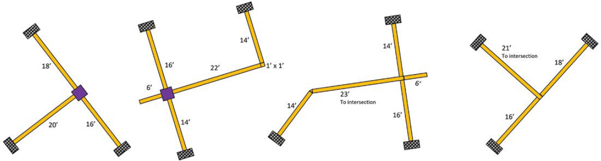
The TWSI network configurations used in the second experiment allowed for testing three CPI treatments: (1) no indicator (12-in.-wide guidance surface path only), (2) a 3 × 3 ft square of truncated domes, and (3) a 3 × 3 ft blank space. To meet the objectives, guidance surface paths were arranged in four separate networks (Figure 2):
- A three-leg TDI path intersection with a 3 × 3 ft CPI at the intersection. This area was left blank (blank-space CPI) on some trials and was filled with DWSs (truncated dome CPI) for other trials.
- A four-leg TDI path intersection with a 3 × 3 ft CPI at the intersection. This area could be left blank or could be filled with DWSs. This network also included a TDI path with a 90-degree nonintersection turn.
- A four-leg TDI path intersection without a CPI. At the intersection, the two 12-in.-wide paths simply intersected and abutted one another. This network also included a path with a 45-degree nonintersection turn.
- A three-leg TDI path intersection without a CPI. At the intersection, the 12-in.-wide paths simply intersected and abutted one another.
Findings
By and large, participants had no difficulty following TDI paths that were 12 in. wide with a 4-bar pattern. When needing to follow paths and then continue in a particular direction after
encountering a path intersection, the lack of a CPI at the intersection resulted in significantly lower success rates in specific scenarios, typically involving turns (51–76%, depending on the specific wayfinding condition) than when either a DWS or blank-space indicator was used (90–94%). There was no significant difference between having no CPI and having an indicator in scenarios where (1) the participant was instructed to continue straight at the intersection, and (2) at T-intersections, when the participant started on the leg of the T or started along the top of the T on the side of the TDI path closer to the leg of the T. The evidence demonstrates that there is significant value in having a CPI at path intersections, and the available evidence suggests the DWS and blank-space indicators were equally effective.
Given that in the United States truncated dome DWSs are used as warnings at hazards (e.g., at the bottom of curb ramps before entering the street, at elevated transit platform edges), the blank-space CPI was selected for use in the field experiment. Given the blank space’s equivalent performance relative to the DWS CPI, it is preferable to reserve the use of truncated domes for situations where they provide a warning. In addition, blank-space indicators would be less expensive to install and maintain, as they consist of an empty space free of any TWSI.
Somewhat surprisingly, the average success for navigating 45- and 90-degree turns in TDI paths were a bit lower than the success rates in navigating path intersections with CPIs. It is possible this result was an artifact of the experimental design and instructions. Based on the instructions for so many of the other trials, participants may have become accustomed to being told when they would need to make a turn, so these nonintersection turns posed problems in the experimental context. Alternatively, there may be features of such turns that make them difficult to navigate.
Field Experiment
Experiment Design
The field experiment took place in and around transit facilities in an urban area in Charlotte, NC. The installation was designed with an effort to deploy TWSIs in a network-like manner to improve accessibility in, and create a greater degree of accessible connections between, several transit facilities (light rail station, streetcar platform, bus transit center) and a large indoor arena.
Each participant in the experiment received only a small amount of familiarization with the materials and training in their use, typically lasting 30 to 45 minutes. This familiarization occurred in a closed area of a parking garage and included:
- Following TDI paths
- Navigating nonintersection turns in a TDI path
- Detecting CPIs at TDI path intersections (i.e., a blank space) and navigating turns at these intersections
- Detecting and using TDIs that marked transit boarding locations or difficult-to-locate crossings
- Using TDIs to establish alignment
- Detecting, identifying, and stopping at DWSs
- Using TWDs to remain on the proper side of this warning surface
One objective of the study was to evaluate how well participants could subsequently use these different TWSIs for these varied purposes in natural environments after having received rather minimal familiarization and practice. After this familiarization, each participant was led outside and, over the course of approximately 1 hour, was assigned a series of tasks to attempt to complete while making appropriate use of all available TWSIs. All these tasks were performed in active, natural environments. Pedestrians were present and going about their regular activities, and transit and passenger vehicles were operating normally.
Tasks assigned to participants were designed to reflect how a traveler would regularly use the facilities, including:
- Needing to go from a platform on one side of a light rail station across the tracks to the side of the station that exits to the nearby arena
- Needing to exit the light rail station onto an open plaza and then navigate to arena destinations including a fan store and a main entrance
- Traveling away from the arena, locating a crosswalk that serves a midblock, midstreet streetcar platform, and navigating onto that platform
- Navigating from a streetcar platform to a bus transit center via two street crossings
While completing a series of such wayfinding tasks, data were collected regarding participants’ interactions with and use of TWSIs. Along the routes, both preexisting DWSs and temporarily installed TDIs and TWDs were present and intended to provide accessible information regarding various features of the environment:
- Required existing DWSs were present at elevated platform edges in the light rail station and on the midstreet streetcar platform, at an at-grade rail crossing in the light rail station, and at curb ramps.
- TDIs were installed to mark transit boarding door locations, including locations on the light rail platform, the streetcar platform, and a bus bay in the bus transit center.
- TDIs were installed across the full width of a sidewalk to mark the locations of midblock crossings serving the midstreet streetcar platform.
- TDIs were installed to provide alignment information for certain street crossings and for transit boarding.
- TDIs were installed on plaza areas outside the arena to provide a network of paths that could be followed to and from a series of points of interest: the entrance from the light rail station serving the arena, a fan store at the arena, stairs connecting upper and lower plaza areas around the arena, one of the main entrances to the arena, and a sidewalk running the length of the arena adjacent to a plaza providing access to a main entrance.
- TWDs were installed to provide a warning surface at a location adjacent to an at-grade rail crossing in the light rail station.
Findings
Participants were given a significant number of tasks that encouraged the use of three different types of TWSIs, with TDIs being used for multiple purposes and in somewhat distinct arrangements for different tasks. Additionally, these participants attempted all these tasks after only
30–45 minutes of familiarization, training, and practice. Except for DWSs on elevated transit platforms and at curb ramps, most participants had limited prior experience with these materials being employed for these purposes. In addition, participants had a range of experience across various environments and underlying tasks (e.g., light rail transit stations, midstreet transit platforms, street crossings). Nevertheless, the experimental installations of TWSIs appear to have supported completion of numerous ecologically valid tasks in real-world environments (e.g., find the location of the pedestrian crossing to cross from one side of a station to the other; find a particular point of interest near a large open plaza area; find a midblock crosswalk and cross to a midstreet transit platform).
The field experiment revealed at least a few areas needing additional consideration and/or research. First, where TDIs were used to mark transit boarding locations, participants were highly successful using them as intended once they were contacted. However, where the TDIs did not extend across most of the platform, walkway, or sidewalk, participants frequently failed to contact them when first navigating down the walkway. The data suggest there is value in having these TDIs extend across much or all of the walkway, but in some contexts (e.g., center platform with tracks on both sides), it raises questions about how to do that.
Second, the field research highlighted challenges for pedestrians with vision disabilities in finding a TDI path and establishing their initial heading along the path. For example, if a transit facility has paths throughout, and if those paths start or end at key features (e.g., entrance to the station, stairs, elevator), how should the paths be laid out in the area near these features to ensure travelers will be able to find the path without much searching? In addition to other concerns, searching increases the likelihood of becoming disoriented before finding the path and thereby makes it more difficult to establish the correct heading along the path.
Third, there remains somewhat limited evidence about the ability of pedestrians with vision disabilities to follow TDI paths efficiently and successfully when those paths turn (i.e., nonintersection turns). Are certain types of turns easier to follow (e.g., turns up to a certain number of degrees, curved vs. angled turns), and how are turns understood by individuals with vision disabilities in relation to providing instructions for routes or otherwise encountering and using turns along routes? To date, the research on this topic has always involved participants with very limited experience following such paths. It is unknown whether additional experience would change the understanding of what might be needed (e.g., with very limited experience, such turns pose some difficulty, but with even a little additional experience, it may become a nonissue).
While some questions remain, the overall level of participant success in the field experiment, given limited experience and training, appears to validate the effectiveness of the TWSIs in natural environments in the ways that prior experimental evidence has supported.
Guide Outline
This guide provides background information about TWSIs and guidance for planning, designing, implementing, maintaining, and assessing the effectiveness of a tactile wayfinding system. It is suggested that readers new to the subject read the entire document and then refer to individual chapters as needed as a project progresses from concept to implementation. The guide consists of six chapters:
- Introduction. Chapter 1 provides the purpose and scope of the guide, the intended audience, and an outline.
- Background. Chapter 2 is designed for readers new to the topic of tactile wayfinding. It starts by describing typical techniques and cues used for wayfinding by vision-impaired people and the need for tactile wayfinding. Next, it introduces the types of TWSIs covered in this guide,
- the messages they are intended to convey, their typical applications, and their need to be both detectable by people with vision impairments and discriminable from each other. It concludes with a brief history of the evolution of tactile wayfinding in the United States and internationally and a summary of current U.S. practice in applying TWSIs in public right-of-way and transit settings.
- Transit Facility and Other Plaza-Type Applications. Chapter 3 provides information useful to practitioners as they plan and design TWSIs for a station or other plaza-type application such as a pedestrian plaza or shared street. It presents a variety of example applications for different rail and bus transit platform configurations.
- Crossing Applications. Chapter 4 provides information useful to practitioners as they plan and design TWSIs for pedestrian street crossings, either at intersections or midblock, or to cross rail tracks at grade. It presents example applications that illustrate common curb ramp configurations.
- Implementation. Chapter 5 provides guidance on selecting the TWSI materials to be used in a planned tactile wayfinding system, along with information for orientation and mobility specialists for training pedestrians with vision disabilities on how to use the system.
- Postimplementation Activities. Chapter 6 covers the importance of assessing the effectiveness of a tactile wayfinding system after it has been installed, system design to minimize future maintenance, routine maintenance activities, and maintaining wayfinding during utility and construction work. It also provides brief case studies of four U.S. transportation and transit agencies that have pioneered the use of TWSIs.
Additional Resources
These additional documents and standards are recommended to be consulted in conjunction with applying this report’s guidelines, depending on the project context. Information from these resources is presented in this guide where it is relevant.
- ADA Standards for Transportation Facilities (U.S. DOT 2006) specifies the dimensions of DWSs and requires them at transit boarding platform edges and at the bottom of curb ramps.
- ADA Standards for Accessible Design (U.S. DOJ 2010) also specifies the dimensions of DWSs.
- Public Right-of-Way Accessibility Guidelines (Architectural and Transportation Barriers Compliance Board 2023) sections R205 and R305 specify use of DWSs at various locations.
- Transit Universal Design Guidelines (APTA 2020) addresses tactile guidance paths in a transit station context in section 5.5.7.
- ISO 23599: Assistive Products for Blind and Vision-Impaired Persons—Tactile Walking Surface Indicators (ISO 2019) provides international standards for TWSIs.
- Accessible Shared Streets (Elliot et al. 2017) includes the section “Tactile Walking Surface Indicators and Detectable Edges” that provides the FHWA’s guidance for using TWSIs in a shared-street context.
Chapter 2 discusses additional guidance developed by the National Association of City Transportation Officials (NACTO), the American Society of Landscape Architects, AASHTO, and internationally.


