Managing Highway Stormwater Quality: Driving Progress (2026)
Chapter: 2 Foundational Background
2
Foundational Background
This chapter provides background on the public interest in water quality management and the statutory and regulatory frameworks that govern this management. The background is foundational for understanding the more focused discussion in subsequent chapters about why and how highway stormwater is managed by state departments of transportation (DOTs) and other public agencies that own, operate, and maintain highway infrastructure. The chapter starts by explaining why water in its many forms should be viewed as an interconnected resource that warrants integrated and holistic approaches for managing water quality and availability interests.
The Clean Water Act and its major provisions governing water quality management are then reviewed with a focus on stormwater regulations and the total maximum daily load (TMDL) process. This is followed by an introduction to stormwater best management practices (BMPs), including their functions and pollutant removal mechanisms. Finally, background on hydrologic and stormwater models is reviewed along with information on how models are involved in regulations. Although not specific to highways, the discussion sets the stage for the report’s more detailed examination of stormwater management issues and practices in that domain.
MANAGING WATER AS AN INTERCONNECTED RESOURCE
The continuous redistribution of water in its many forms, including surface water, groundwater, and snowpack, is controlled by processes of the hydrologic cycle, such as precipitation, evaporation, infiltration, and runoff (Figure 2-1). While this study is charged with focusing on best practices for
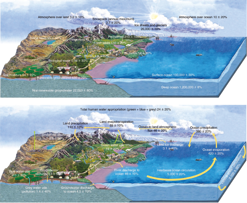
SOURCE: Abbott et al., 2019.
managing stormwater runoff from highway facilities, it is important to recognize that water is a single, interconnected resource. Increased recognition of this interconnectivity, coupled with growing concerns about the availability of freshwater supplies and flooding events, have prompted interest in more resilient and integrated approaches for managing freshwater resources.
Historically, water management practices and regulatory frameworks compartmentalize the various forms of freshwater resources (e.g., surface water is considered separately from groundwater) and their quality and availability for end uses (e.g., industrial, agricultural, municipal drinking water, recreation, fisheries). Furthermore, these practices and frameworks often treat water quantity and quality interests separately. However, overall water availability is affected by both the quantity and quality of freshwater resources. Quantity concerns range from too little to too much water: Adequate water supply is critical to avoiding drought impacts and supporting habitat for aquatic organisms, but too much water, such as in extreme weather events, also has to be considered by water managers. Water quality issues arise as water picks up and transports contaminants as it moves through landscapes, including stormwater runoff flowing from developed surfaces and into soils and other surface and groundwater resources. For example, some stormwater management practices effectively remove contaminants from surface and groundwater, while other management practices only consider surface water and merely alter the pathway of contaminant transport through watersheds. Such practices may increase contaminant infiltration to underlying groundwater to adversely affect the quality of local groundwater supplies (McQuiggan et al., 2022). The same receiving groundwater may be hydrologically connected to adjacent surface water supplies, resulting in exchange of water, nutrients, and contaminants. These alterations of contaminant pathways through watersheds and by management strategies are not well understood and may be a problem, an opportunity, or a solution, but understanding pathways is critical in managing water as an interconnected resource.
Water management practices have also had to adapt to a hydrologic cycle that is being modified by changes in human uses of water, land use, and temperature and precipitation patterns. Human use of water for agriculture, industry, transportation, and other purposes alters the quality and quantity of water bodies (e.g., streams, rivers, lakes, estuaries, groundwater), while changes to land also disturb natural hydrologic conditions and patterns throughout watersheds (Abbott et al., 2019). Urbanization has led to watersheds with higher impervious land cover, creating an “urban stream syndrome” of ecological degradation, including flashier hydrographs, elevated contaminant concentrations, and altered channel morphology in streams draining urban land (Walsh et al., 2005). Changing precipitation and temperature patterns create additional water management issues. Increases
in the frequency and duration of extreme precipitation events can pose a particular challenge for stormwater management, as many legacy management practices were designed and situated based on historic hydrologic data (Liu et al., 2023). In addition to producing high runoff volumes that can have devastating flooding impacts, extreme and prolonged precipitation events can mobilize contaminants in ways that were not anticipated by traditional stormwater management practices. These weather events can even cause systems designed to intercept and retain contaminants to become contaminant sources when inundated (Jiang et al., 2023). Coastal areas have additional water management challenges from storm surge flooding and changing tides and sea levels.
When precipitation events become increasingly intensified, prolonged dry periods can be interspersed with shorter, high-magnitude wet periods (e.g., cyclic droughts, atmospheric rivers, tropical cyclones) as has occurred in some areas of the United States (Tabari, 2020). Rapidly onsetting (“flashier”) precipitation regimes will result in different contaminant loading dynamics in stormwater runoff relative to historic conditions. For example, the “first flush” following a dry period is known to generally have a higher loading of sediment and other particulates in runoff than in subsequent rain events (Hathaway et al., 2012; Lee et al., 2004). With increasing duration of dry periods between runoff events, more first flush events with high contaminant loads may occur (Chaudhary et al., 2022). Pollutants, including metals and nitrogen, can also be transported directly from air to land through wet and dry atmospheric deposition (Gunawardena et al., 2013; Jani et al., 2020; Sabin et al., 2005). Similarly, during dry periods, declines in streamflow of receiving water bodies may result in increased sensitivity to contaminants and other impacts to aquatic species as less receiving water is available to dilute contaminants, some of which may be naturally occurring (e.g., arsenic).
A more thorough discussion of the implications of the interconnectivity of water resources and the dynamics of the hydrologic cycle can be found in many other publications (Abbott et al., 2019; Pringle, 2001; Yang et al., 2021). The elements highlighted in this report acknowledge the significant complexities interconnected water resources create for stormwater management, especially when management approaches and activities are conducted in an isolated or static manner.
REQUIREMENTS OF THE CLEAN WATER ACT AND THEIR IMPLEMENTATION
The Federal Water Pollution Control Act of 1948, precursor to the Clean Water Act (CWA), was the first major U.S. law to address water pollution. It sets out the basic structure for regulating pollutant discharges into the waters of the United States. While the definition of “waters of the United States”
has been a long-standing topic of debate and litigation, it has remained limited to surface waters and thus does not include groundwater. Enacted in 1972, the CWA represented a significant reorganization and expansion of the earlier act to restore and maintain the chemical, physical, and biological integrity of the country’s waters. The CWA’s modern form derives from the 1972 Act, although it has been amended several times since.
According to the CWA and its regulatory structure, it is unlawful to discharge any pollutant from a point source into waters covered by the Act without a permit. “Point sources” are defined as any discernible, confined, and discrete conveyance, such as a pipe, ditch, channel, tunnel, conduit, discrete fissure, or container. The parties responsible for a point source are required to seek permit coverage under the stormwater discharge National Pollutant Discharge Elimination System (NPDES) permit provisions of CWA Section 402. Water pollutant sources that do not meet the definition of a point source are generally considered “nonpoint” sources and are addressed differently, as explained below. Stormwater runoff pollution originates from distributed sources across a landscape, which is characteristic of nonpoint source pollution, but it is often regulated from a legal perspective as a point source when discharged from a single point (e.g., a drainage outfall).
While a detailed discussion of the CWA and its requirements is beyond the scope of this report, the following overview of the Act’s requirements related to the establishment of water quality standards, discharge permits, and water quality assessments is necessary as a prelude to the more detailed discussion in subsequent chapters of the CWA regulations as they apply to pollutants in highway stormwater discharges.
Water Quality Standards and Designated Water Uses
The CWA sets forth the goal of restoring and maintaining the integrity of the nation’s waters to ensure they are fishable and swimmable. To meet this goal, each state must establish its own water quality standards for waters of the United States1 and seek approval for the standards by the U.S. Environmental Protection Agency (USEPA). States may also adopt USEPA’s nationally recommended water quality criteria published pursuant to Clean Water Act 304(a). Additionally, each state must conduct a triennial review of its water quality standards and offer the public an opportunity to comment.
Water quality standards are a foundational component of water quality management programs. They define the water quality goals for a given body of water consistent with its designated beneficial uses, such as for drinking water, aquatic life, recreation, or agriculture. Each beneficial use can have narrative and numeric standards for various pollutants intended to protect
___________________
1This paragraph was changed after release of the report to reflect USEPA’s regulatory language.
that use. States are also required to conduct water quality assessments and update their list of impaired waters every two years to determine the status of a water body’s compliance with standards.
In addition to the water quality standards governed by the CWA, states can be subject to other federal and state laws governing watershed management, thereby adding another set of regulations for specific water bodies. Some states, for instance, have quality standards for groundwater that do not fall within the scope of the CWA but that are governed by the federal Safe Drinking Water Act and similar state laws. The state of Washington’s NPDES permits, for instance, are combined with State Waste Discharge permits because groundwater is considered jurisdictional under the state’s Water Pollution Control Act.2
Identification of Impaired Water Bodies
The CWA requires states to identify waters that do not or are not expected to meet applicable water quality standards. Sections 303(d) and 305(b) of the CWA require states to develop a process for assessing water bodies for water quality and identifying those that do not, or are not expected to, meet applicable water quality standards and place them on a monitoring and evaluation (M&E) list. Such 303(d) and 305(b) lists are generally combined by states into one Integrated Report for submittal to USEPA. For waters reported as impaired [303(d) listed], TMDLs must be prepared. A TMDL is the calculation of the maximum amount of a pollutant allowed to enter a water body to enable it to meet water quality standards for that particular pollutant. A TMDL identifies pollutant sources and establishes allocations that are necessary to meet the calculated TMDL.3
Water bodies on the 303(d) list fall under five general categories of water quality attainment condition. The most common categories warranting attention include Category 3b, meaning the segment is on the monitoring and evaluation list and could be listed as impaired in the future; Category 4a, meaning that a TMDL has been completed but the water body does not meet the standard; and Category 5, meaning that the water body is impaired and a TMDL is needed.
TMDLs
As noted above, a TMDL is (a) a calculation of the maximum amount of a pollutant that a water body can receive and still meet water quality standards and (b) a determination of the amount of that pollutant that sources can contribute and still meet water quality standards. The purpose
___________________
2Revised Code of Washington 90.48.030.
3This paragraph was changed after release of the report to clarify USEPA regulations per CWA 303(d).
of a TMDL is to bring a water body into compliance with water quality standards to support the designated uses of the water body. TMDL requirements may include wasteload and load allocations in the form of a load reduction target assigned in pounds or percent reduction, or as assigned actions, such as a requirement to provide water quality treatment at a specific discharge location. Figure 2-2 shows schematically the connection between water quality standards, the 303(d) list of impaired waters, TMDLs, and NPDES permits.
The basic approach to developing a TMDL begins with identifying the pollutant of concern and then estimating a water body’s assimilative capacity (i.e., loading capacity) and pollutant loadings to the water body from all
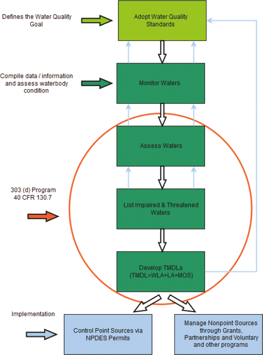
SOURCE: https://www.epa.gov/tmdl/overview-identifying-and-restoring-impaired-waters-under-section-303d-cwa

SOURCE: USEPA presentation to committee on July 30, 2024.
sources. This is followed by an analysis of the current pollutant load and determination of needed reductions to meet assimilative capacity. The final step is to allocate the allowable pollutant load among the different pollutant sources in a manner such that water quality standards are achieved. Figure 2-3 expresses this visually.
To calculate the maximum daily pollutant load (in mass units), a TMDL takes into account both the volume of discharge and the pollutant concentration. A TMDL’s components are (a) wasteload allocations (WLAs) for point sources, (b) load allocations (LAs) for nonpoint sources, (c) a margin of safety, and (d) an optional reserve capacity (RC). The WLA is an estimated amount of the pollutant assigned to point sources within a TMDL boundary that is covered by a discharge permit (i.e., permitted point sources such as wastewater or stormwater outfalls). The LA is an estimated loading that is not covered by a CWA permit, also known as a nonpoint source. Highway runoff falls under the WLAs in the TMDL equation if covered by an NPDES permit, but it is classified as an LA when considered nonpoint and not covered under NPDES. An optional RC allocation may also be calculated to allow for the addition of new discharges; however, its use has historically been uncommon for state DOT–relevant TMDLs. By definition, TMDLs
calculate loads and associated allocations for a daily time period; however, due to the variable nature of some pollutants over time and the improved accuracy of load estimates over longer-term time scales, daily loads can be calculated using longer-term data (e.g., monthly, seasonal, or annual).
Accordingly, a TMDL can be expressed as
TMDL = ∑WLA + ∑LA + MOS + RC (optional)
where
∑WLA = the sum of wasteload allocations.
∑LA = the sum of load allocations.
MOS = the margin of safety, an estimated amount of the impaired pollutant allocated to account for uncertainty in the TMDL process.4
RC = reserve capacity (optional), an estimated amount of the impaired pollutant that is set aside for future development and discharges into the TMDL boundary.
Receiving Water Monitoring
Receiving water monitoring data can also be used to determine compliance with water quality standards, beneficial uses, or the effectiveness of TMDL implementation. This monitoring may be performed by a permittee, such as a city or county, to better understand water quality status and trends within their jurisdiction, or by the regulator as part of the 305(b) program and as part of the TMDL program. Receiving water monitoring is generally not the responsibility of a DOT because they are not regulatory agencies and their discharges are generally just one of many sources of pollution, the others being outside the control of the DOT. In some cases, receiving water monitoring may be useful as a way to measure TMDL effectiveness by showing progress (positive or negative) and informing adaptive management. However, using receiving water monitoring data to determine the effectiveness of TMDL implementation can be very challenging when many sources are involved across a sizable watershed. Measuring TMDL success is discussed in more detail in Chapter 4.
Receiving water quality and flow monitoring provides important information about the health of the water body. Samples collected during non-rain events, or dry weather monitoring, represent cumulative pollutant loading to the system from numerous upstream contributors during baseflow conditions. Receiving water monitoring during storm events demonstrates how the quality and flow of the receiving water body vary during storm events. Both types of monitoring are important, and longer, more robust datasets can provide insights into how stormwater management efforts in the drainage area impact water quality and flow rates.
___________________
4This sentence was changed after release of the report to clarify the TMDL process.
Receiving water quantity and quality monitoring can be used to generate a simple analytical tool that integrates both a flow duration curve (cumulative frequency distribution of flow volumes), and flow-dependent pollutant concentrations to provide the load duration curve (LDC). The LDC is the pollutant mass load distribution, which can aid in interpreting the delivery of the pollutant load by different flows. Ideally, monitored or modeled flows and pollutant concentrations should characterize the concentration-discharge dependence. A benchmark pollutant concentration based on a water quality standard can be used to construct a reference LDC for comparison to the empirical LDC. The advantage of this tool is the ability to interpret what flows are delivering the bulk of a pollutant load, potential sources, and appropriate methods of mitigation.
Volunteer citizens and public interest groups will sometimes collect water quality data, which are submitted to databases like the Water Quality Portal.5 Citizen water quality data can be helpful for identifying pollution sources and tracking trends in water bodies but require verification of adherence to data accuracy and quality control protocols.
Discharge Permits
A central feature of the CWA is the Section 402 permitting program for point sources. This section establishes the NPDES permitting program, which is intended to limit the discharge of pollutants from these sources. The NPDES permits apply to discharges of both wastewater and stormwater. It merits noting that most states and some tribal organizations have been delegated authority by USEPA to administer the NPDES program, and some states have adopted their own nomenclature for their delegated program (e.g., Colorado Pollutant Discharge System permit and Vermont Transportation Separate Storm Sewer System General Permit).
Following passage of the amended CWA in 1972, the NPDES permitting program focused on controlling pollutants sourced from municipal wastewater and industrial discharges. Stormwater permitting was added during the 1990s. Although stormwater runoff pollution will originate from distributed sources across a landscape, which is characteristic of nonpoint source pollution, this runoff is considered a point source (from a legal perspective) when discharged from a single point (e.g., a drainage outfall). For other nonpoint sources, or discharges that are not covered under a NPDES permit, load allocation reductions are implemented on a voluntary basis. Nevertheless, when USEPA establishes or approves a TMDL that allocates pollutant loads to nonpoint sources, it determines whether there is reasonable assurance that the LAs will be achieved.
___________________
5https://www.epa.gov/participatory-science/participatory-science-water-projects
Nationally, stormwater permitting occurred in a phased manner. Phase 1 of the NPDES Stormwater Program applies to “municipal separate storm sewer systems” (MS4s) serving medium and large cities or certain counties with populations of 100,000 or more. An MS4 is any network of drainage systems, including pipes, ditches, and other conveyances, designed to carry stormwater runoff directly to nearby streams, rivers, and other bodies of water. Phase 2 applies to small MS4s serving urban areas with a population of at least 50,000.6 Currently, Phase 2 may also include nontraditional MS4s such as departments of transportation, public universities, hospitals, and prisons.7 MS4 permits do not cover discharges to groundwater. While they are currently listed within Phase 2 by USEPA, state DOTs fit into Phase 1 and 2 designations in different ways from state to state, often depending on when a permit was created.
The NPDES program employs the following two approaches for maintaining and protecting surface water quality through the use of discharge permits:
- Technology based, with the goal of achieving a specific level of end-of-pipe performance. This approach focuses on meeting effluent limits for specific pollutants based on the expected performance of treatment and control technologies.
- Water quality based, with the goal of meeting water quality standards in a receiving water. This approach focuses on meeting limits based on what is needed to achieve water quality standards.
Wastewater discharge permits generally include technology based effluent limits and water quality-based effluent limits. The water quality–based approach is most commonly applied for managing pollutants in stormwater runoff. As discussed in more detail later, stormwater treatment is implemented to the “maximum extent practicable” through structural and nonstructural practices, recognizing that the level of treatment consistently attainable for municipal wastewater is different than that achievable for urban stormwater.
BEST MANAGEMENT PRACTICES FOR STORMWATER
BMPs are techniques and structural controls used under a given set of conditions to mitigate the effects of runoff on downstream receiving water bodies; they are designed to manage the quantity and improve the quality of stormwater runoff. Collectively, BMPs are often viewed as a “toolbox”
___________________
6This section was changed after release of the report to correct the population size in USEPA regulations and more accurately reflect USEPA regulations on wastewater discharge permits.
7https://www.epa.gov/npdes/stormwater-discharges-municipal-sources
of practices because they may include a suite of structural systems and technologies and pollution prevention practices, also known as source controls. Engineered or constructed facilities are usually passively operated systems and can include wetlands or infiltration basins that reduce pollutant loading and modify volume and flow, while preventative practices can be more active, including educational activities and site design improvements that limit the generation of stormwater runoff or pollutants. Preventative practices may include source control of pollutants, such as reforestation of areas prone to erosion, disconnecting impervious surfaces from storm sewer systems to direct water to green spaces, choosing phosphorus-free fertilizer, and stream channel and floodplain restoration.
Stormwater BMPs can have water quality and hydrologic (volume, peak flow) objectives, and they can also serve multiple purposes. BMP design may be influenced by the CWA and other regulatory and watershed or site-specific goals. Most are designed for conditions typical of anticipated benchmark storm events such as the 85th-percentile storm or annually occurring events. Some are designed for larger storm events (i.e., that may occur every 2 to 5 years), typically by reducing the magnitude and duration of flow to protect the physical integrity of streams and rivers from erosion and subsequent deposition. By comparison, flood control practices are designed for infrequent events (e.g., 10- to 100-year 24-hour storms) where the objective is to protect downstream property from damage and prevent loss of life.
Most BMPs are designed for the current site conditions and with design guidance from state, regional, or local stormwater manuals. Guidance for pollutant control, or water quality treatment, will usually involve one or more processes, including sedimentation, filtration, adsorption, and biological and microbial transformations. Volume control is most commonly achieved through holding water in shallow ponds or basins, or in a soil medium, where it can infiltrate through the unsaturated zone into subsoils or evapotranspire through vegetation. Peak flow control is usually addressed through temporary ponding of stormwater and gradual release through a hydraulic control structure. Figure 2-4 displays an example of a BMP collecting stormwater.
The following are some common BMP descriptions, functions, and subgroups. Note that specific terminology may differ from place to place; for instance, the term stormwater control measure may be used synonymously with BMP, depending on the region or state. Also, a single BMP may fall into one or many of the below groups.
BMP Physical Attributes:
- Structural BMPs: A permanent structure or device that is designed, constructed, and maintained to remove pollutants from stormwater runoff by promoting settling, sorption, or filtration; or to mimic the natural hydrologic cycle by promoting infiltration, evapotranspiration, post-filtration discharge, reuse of stormwater, or a

SOURCE: Virginia Transportation Research Board, Report No. 25-R3, 2024.
- combination thereof. Examples include retention or infiltration basins and constructed wetlands.
- Source controls (also known as nonstructural BMPs): Practices, programmatic activities, and land use regulations or activities that prevent or minimize runoff from being generated or pollutants from being entrained into runoff. An example is street sweeping. The term “nonstructural BMP” is no longer common in regulatory language, as the concept is subject to widely varying interpretations.
- Green stormwater infrastructure: A subset of structural BMPs that use nature-based design to meet mitigation criterion by taking advantage of natural processes to slow, spread, retain, evaporate, infiltrate, and filter stormwater runoff before it is discharged to receiving waters. Examples include bioretention and bioswales.
BMP Temporal Attributes:
- Permanent or post-construction BMPs: structural BMPs constructed to provide water quality and/or flow control for the service life of the asset.
- Temporary BMPs (also known as construction BMPs): structural BMPs used during the construction phase such as silt fences, erosion control blankets, and temporary sediment basins that are removed once the site is stabilized and permanent erosion control is installed.
BMP Functional Attributes (BMPs often have more than one):
- Water quality BMPs: The design intent is to prevent, treat, or otherwise manage contaminants. Runoff management may be achieved by volume control or introducing physical, chemical, and biological pollutant removal mechanisms.
- Flow control BMPs: The design intent is to mitigate the maximum runoff rates and duration of peak flows, and to manage flow volumes for physical habitat protection, sewer and combined sewer overflow mitigation, or flood control.
- Infiltration BMPs: BMPs that manage water by encouraging infiltration of stormwater from aboveground surfaces into the ground where it may pass through soils and percolate into groundwater.
BMP Spatial Attributes:
- Distributed BMPs: Runoff is managed close to its source by multiple smaller footprint BMPs. “Small” refers to collecting runoff from a drainage area of several acres or less, depending on the specific type of BMP and its technical design. Examples of BMP types that can be designed for small drainage areas include biofiltration/bioretention, permeable pavement, and infiltration trenches.
- Regional BMPs: Runoff from large drainage areas (in excess of several acres) can in some cases be managed in a single BMP or treatment train. Some BMPs are conducive to regional-scale implementation, such as extended detention basins, retention basins, wet ponds, constructed wetlands, and subsurface infiltration galleries or cisterns. Constructing regional-scale BMPs requires adequate drainage infrastructure to physically convey runoff from a large area, usually by gravity feed, to a single location, and the availability of land for a large footprint BMP. Regional-scale BMPs may be referred to as “end-of-pipe” solutions. Some states require pretreatment and other conditions prior to discharging to a regional facility. Regional BMPs are usually owned and operated by public agencies.
- Linear BMPs: Narrow BMPs that extend along a line and are often adjacent and parallel to other linear features such as roads or stream channels.
Because TMDLs are most commonly focused on achieving water quality standards, the remaining sections explain how BMPs are designed for the purpose of removing and reducing pollutant loads in runoff. The basic unit treatment processes for pollutant removal are described with some
considerations about realistic expectations for BMPs in meeting TMDL objectives.
Stormwater Unit Treatment Processes
BMP “unit treatment processes” (the processes that explain how BMPs function) consist of a range of hydrologic, physical, biological, and chemical mechanisms. A BMP may have a series of unit treatment processes, depending on the site-specific characteristics of the pollutants in the stormwater and the hydrologic characteristics of the system. Many BMPs include unit treatment processes for removing suspended sediment and particulate pollutants. In comparison, fewer processes are available for removing dissolved pollutants (e.g., chloride, nitrate, phosphate, dissolved metals) because they are difficult to remove by sedimentation or physical filtration.
Common unit treatment processes include the following.
Sedimentation: Sedimentation is typically gravity-based quiescent settling of suspended particles and attached pollutants from stormwater. It can be achieved when stormwater is detained for an extended duration (e.g., 48 to 72 hours) to allow settling of sediments. Sedimentation is most successful for pollutants in particulate form and is generally ineffective for dissolved pollutants. For sedimentation to be effective, the flow rate of stormwater has to be slowed down, allowing particles to drop out of the water, as opposed to turbulent flow typical of impervious, piped, and channeled runoff in managed drainage systems. Additionally, regular maintenance to remove sediment is needed to ensure the BMP functions as designed and to prevent scouring of deposited sediments that could resuspend pollutants.
Filtration: Filtration physically traps pollutants as stormwater flows through a porous filter media. Examples of BMPs designed for stormwater filtration include bioretention, sand filters, and permeable pavement. Effectiveness depends on the particle and pore size distributions of media. Filtration can be highly effective; however, eventually the filter media can also be subject to clogging and may need periodic replacement to maintain function. In some settings with high sediment loading, filtration practices may not be suitable unless preceded by pretreatment using a sedimentation-based practice.
Sorption: Sorption is often associated with filtration practices, but in this case dissolved pollutants sorb, or adhere, to the media surface. Sorption may be present in BMPs having a porous media. The effectiveness of sorption will depend on the properties of both the pollutants targeted for treatment and the media (substance used for filtration). When the capacity of media to sorb additional pollutants is exhausted, or reduced below
performance expectations, it will need to be replaced (Komlos et al., 2012). In some cases, disposal of the removed media can be problematic for solid waste landfills due to the presence of metals and hydrocarbons.
Biodegradation: Biodegradation uses microbial action to break down and transform previously trapped pollutants. Biodegradation processes are specific to pollutant and microbe types (e.g., denitrification of nitrate requires anoxic conditions and extended contact times of multiple hours to days at a narrow temperature range) (Donaghue et al., 2022; Igielski et al., 2019).
Vegetative Uptake: Vegetative uptake can contribute to BMP pollutant removal but may later release the same pollutants during plant decay (Payne et al., 2014; Zhang et al., 2022). Pollutants must first be trapped in the media in which the plants grow. Uptake occurs over a longer period of time (between storm events) than for sedimentation, filtration, or sorption (which happens during a storm event). Effective long-term removal of pollutants by vegetation may require periodic harvesting. Vegetation also plays an important role in evapotranspiration, maintains infiltration pathways, and mitigates heat.
Deactivation/Disinfection: For microbial pollutants, deactivation of microbes or disinfection of the water is necessary. For example, UV exposure can result in deactivation of pathogens. In wastewater treatment plants, UV, chlorine, or ozone dosing is used for disinfection in active treatment processes; however, such active treatment is typically not present or practical in stormwater BMPs, which are commonly passive. In a passive system, runoff needs to be in direct contact with sunlight with low turbidity for a period of time for pathogens to be deactivated. Disinfection may be used for dry weather flows from storm sewer systems in cases of persistently high fecal indicator bacteria, but it is not commonly used for stormwater flows.
Temperature Reduction: Mitigation of increased runoff temperature from heated surfaces is sometimes required. Movement of runoff through underground media beds can act as a cooling mechanism for this purpose. Thermal loads can also be reduced through volume reduction (infiltration and evapotranspiration) or shading from vegetation or other structures.
The National Cooperative Highway Research Program (NCHRP) has sponsored studies to advance understanding of unit treatment processes used for highway stormwater applications. NCHRP Report 918, “Approaches for Determining and Complying with TMDL Requirements Related to Roadway Stormwater Runoff” (TRB, 2019) contains a summary of unit treatment processes according to various categories of BMPs, as shown in Figure 2-5. The next chapter provides more detail on stormwater management in the highway domain, including on the BMPs used for this purpose.
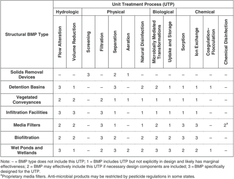
SOURCE: NCHRP Report 918 (TRB, 2019).
MODELING
Hydrologic and Stormwater Models: Purposes, Goals, Context
In the absence of direct measurements of water properties or to predict future water system behavior, mathematical relationships are used to model water systems. Hydrologic and stormwater models are created based on empirical observation-based statistical associations and/or mechanistic processes and theory-based equation sets. TMDLs may be developed based on a combination of sampling and models. Given the frequent scarcity of sampled runoff, models are essential tools to estimate contaminant loads and extrapolate beyond available data. Models are used to assess current contaminant loadings from a watershed and to develop wasteload and load allocations to protect downstream beneficial uses. Models are also developed to evaluate strategies to achieve protection or restoration goals, including estimating the effectiveness of BMPs on the control of runoff volumes and contaminant loads. Some pollutants can be well represented
by models, whereas others, such as bacteria, are more difficult to model. Modeling generally requires significant technical expertise that is often performed by contractors outside of the public agencies.
Overview of Model Evolution in Response to Regulations
Modeling and monitoring should be pursued as complementary and coupled activities. Models require appropriate observational data—that is, information gathered by observing and recording events, behaviors, or phenomena as they occur—to ensure accuracy, validity, and reliability. Analysis of monitoring data benefits from model interpretation and extrapolation to circumstances beyond what can be sampled. Modeling and monitoring approaches have evolved over time from simple runoff and load determinations at an outfall pipe or watershed outlet to more complex, multi–flow path, and biogeochemical representations over a full drainage area. This evolution has been in response to increasing data availability, measurement technology, process understanding, computational capacity, and increased attention to predictive uncertainty. A set of commonly used models for stormwater and TMDL applications were developed in a more data-limited period, with less understanding of watershed hydrology, pollutant transport, and transformation processes. Initial emphasis has been on primary water pollutants (those that are transported by stormwater), while attention to secondary pollutants (those that arise or are mobilized from an interaction with a primary pollutant) as reaction products within watersheds has lagged. BMP representation in prevailing watershed models remains simplistic, despite advances in watershed modeling. Choosing the appropriate level of complexity and effort in a modeling/monitoring approach is subject to the nature of physical and water quality impacts, local environmental and socioeconomic conditions, available resources, and regulatory requirements.
Functions of Models: Hydrology, Hydraulics, and Biogeochemistry
Models are mathematical representations of real-world conditions, which can be very complex. Given this complexity, an old mantra for models is, “All models are wrong, some are useful” (Box, 1976).
Successful water quality modeling (in terms of simulation program results that match observational data) presupposes successful hydrologic modeling (Obropta and Kardos, 2007; Vaze and Chiew, 2003); the mass of a pollutant is equal to the concentration (water quality) multiplied by the volume (water quantity). Input data for hydrologic and water quality modeling are known with different degrees of certainty. Data limitations should be clearly stated when models are utilized.
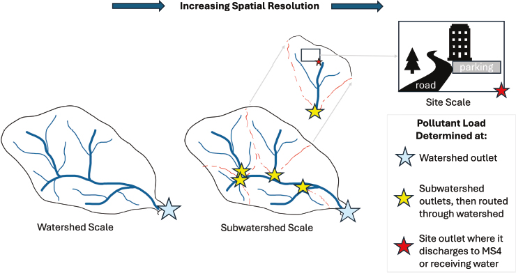
SOURCE: Study committee.
Land surface heterogeneity (land use, soils, vegetation, flow paths) representation in models can range from highly averaged to more detailed spatial distributions. Figure 2-6 depicts the different spatial resolutions of stormwater models. Major classes of approaches include lumped, semi-distributed, and distributed
- Lumped land use/event mean concentration (EMC) event-based models follow a simple paradigm of assigning a single runoff rate and event mean concentration (EMC) to a contributing watershed area based on area-weighted land use and soil types. They do not distinguish between flow paths (surface water, subsurface water) or biogeochemical transformations from contaminant source to streams. Models are spatially “lumped,” with loading estimated at a specified outlet, and are developed for specific time steps (e.g., annual, seasonal, daily, storm event).
- Semi-distributed models: More complex model paradigms distribute streamflow, contaminant concentrations, and loads by subwatersheds or sewersheds, but retain a lumped approach within these regions. These semi-distributed models break up a watershed into primary tributary components and route subwatershed flows and loads through the drainage network. These methods are enabled by GIS methods to partition watersheds into component drainage
- areas and integrate spatially distributed land use and soils data by subwatershed or sewershed areas. However, they also do not include routing through surface and subsurface flow paths to the nearest stream, instead producing runoff and loads at area outlets as area-weighted sums of contributing area.
- Distributed, continuous models: Still further complexity is incorporated by fully distributed, continuous approaches that simulate water and contaminant flows and mass balances at fine resolution (e.g., grid cells or flow elements with dimensions ranging from meters to hundreds of meters), and route water and constituents through coupled surface water and/or groundwater flow paths. A full set of hydrologic and biogeochemical mass balances as well as transport and reaction dynamics may be integrated within these flow paths, as well as ecosystem uptake and release. These models are more complex with a greater number of parameters, geospatial data, and process data. These are largely research rather than operational models, although a set of these models is being adopted by regulatory agencies and consultants for use in applications.
Rainfall-Runoff Modeling
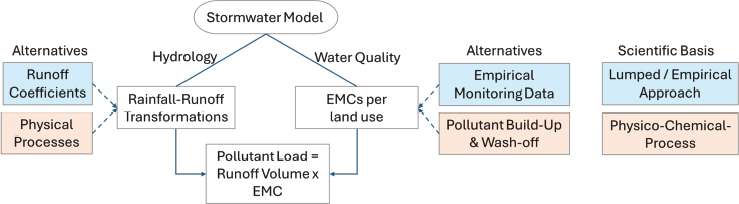
In hydrologic modeling, sometimes called rainfall-runoff modeling (Liu et al., 2015; Tal-maon and Ostfeld, 2024), rainfall is converted to runoff at each time step through well-defined physical processes (Aryal, S. et al., 2009; Nodine et al., 2024). Rainfall data are increasingly available from field instruments and radar systems. The rainfall-runoff transformation may be modeled using empirical runoff coefficients that apply fixed relationships between the amount of rainfall and the fraction of that rainfall that converts into runoff depending on the land use/land cover and soil type. These models are typically implemented as spatially lumped or semi-distributed. The most common runoff coefficients are known as Rational Method runoff coefficients and Curve Numbers that are used with the NRCS TR-55 method (NRCS, 1986). More sophisticated models implement physical processes accounting for infiltration, typically using equations simplified from the Richards equation such as the Green and Ampt method (Green and Ampt, 1911) and the formation of surface flows (such as the St. Venant equations, which are partial differential equations derived from the Navier-Stokes equations for conservation of mass and momentum [Rossman, 2010]).
The physics of surface water hydrology is well understood. The most rigorous surface water hydrologic models quantitatively represent physical processes of water transformation (rainfall or snowmelt to runoff) and movement (routing overland or through conveyance networks) as distributed models. These models can typically provide good predictions of surface
runoff volumes and rates of flow given sufficient information on rainfall, land surface cover, soils, topography, channel/pipe network morphology, and roughness. Examples of existing models with advanced surface hydrology and conveyance system hydraulics used for physically based prediction of flow peaks, timing, and duration include the USEPA Storm Water Management Model (SWMM), the U.S. Army Corps of Engineers (USACE) Hydrologic Engineering Center River Analysis System 2D, and the U.S. Department of Agriculture Kinematic Runoff and Erosion Model. While these models are commonly used and supported by U.S. federal agencies, there are also many other proprietary or research-grade models. Where data are available for calibration and validation, models are more reliable. However, given the sparsity of quality assured rainfall-runoff observations, models are often used to estimate stormwater runoff characteristics in unobserved sites, leading to increased uncertainty of results.
Stormwater models that make greater use of empirically derived rainfall-runoff tools based on contributing watershed land uses, soils, and topographic morphology include NRCS Curve Numbers, Unit Hydrographs, and fixed runoff coefficients, which are typically lumped or semi-distributed by subwatershed areas. These include models such as the NRCS TR-20 and TR-55, USACE Hydrologic Engineering Center Hydrologic Modeling System, and the USEPA Hydrological Simulation Program-Fortran, which may provide a mix of more physically based methods and empirically derived tools. Even more simplified models that use land use–based runoff estimates include a set of spreadsheet calculators such as the Virginia Runoff Reduction Model (VRRM) and are typically fully lumped. In the past two decades, the resolution of commonly available topographic, land cover, and to a lesser extent soils information required by these models has increased by orders of magnitude, allowing much finer assessment of contributing area conditions influencing runoff generation and routing. Subsurface pipe conveyance information (e.g., storm sewer networks) is variably known due to age, deterioration rates, and recordkeeping, contributing to model uncertainty.
Water Quality Modeling
In water quality modeling, the concentration of a pollutant in runoff is often assumed to be a function of the land type on which the runoff is generated (Aryal, R. et al., 2009). While land-use data are typically available (Dewitz, 2021), high-resolution land-use studies for pollutant concentration data are more sparse (Tiefenthaler et al., 2001). Stormwater quality models generally rely on stormwater quality monitoring data. A commonly used stormwater quality monitoring parameter is the EMC, which is the mean concentration of a given stormwater contaminant over the course of a single storm event.
EMCs are based on multiple representative stormwater samples combined using a stormwater flow volume-weighted basis throughout a storm. The National Stormwater Quality Database8 is one of the largest readily available repositories of coupled land-use and EMC data for the United States (Pitt et al., 2018). For highway runoff specifically, the National Highway Runoff Database is the largest centralized database that is used to support the U.S. Geological Survey’s (USGS’s) Stochastic Empirical Loading and Dilution Model (SELDM).9 A range of build-up and wash-off models have been developed to more accurately capture the concentration of pollutants in stormwater runoff (Assaf et al., 2024; Chow et al., 2012; Dotto et al., 2010; Santhi et al., 2014; Sartor and Boyd, 1972). Developing data for calibrating water quality models often requires significant field monitoring campaigns (Simpson et al., 2023; Tiefenthaler et al., 2001) and lengthy and expensive laboratory analysis (Liu et al., 2014).
Coupled land-use–concentration data or build-up/wash-off modeling to generate pollutant loads at any model spatial scale are options available in some commonly used stormwater modeling software packages, such as the USEPA SWMM (Rossman, 2010). Significant user-driven technical information is required to parameterize these functions. As a result of one or more of these technical challenges in parameterizing water quality models, water quality simulation programs have lagged behind public perceptions of water quality initiatives (Bitterman and Webster, 2024). Figure 2-7 depicts the different components of a stormwater model.
Water quality models are generally much coarser than hydrologic models both in terms of spatial detail and basic processes. Water quality parameterization and accounting for BMP effects on water quality within
SOURCE: Study committee.
___________________
8https://bmpdatabase.org/national-stormwater-quality-database
9https://www.usgs.gov/data/highway-runoff-database-hrdb-version-120
models such as USEPA SWMM (which has relatively simple water quality functions) requires substantial user-defined technical input. While a set of ecosystem/biogeochemistry models includes detailed biogeochemical cycling at plot or patch scales, very few if any stormwater models account for the coupled reactions (including reversible processes and the production of secondary pollutants) of the chemical mixtures characteristic of roadways and urban areas at the scale of catchments. Fewer models include coupled surface/groundwater with biogeochemical processing.
TMDL and Watershed Modeling
While most TMDL models share a common workflow, they have a diverse implementation, and the technical rigor and set of hydrologic storage and flow pathways of each step can vary greatly. Load duration curves are commonly used in TMDL development to characterize water quality concentrations at different flow regimes, but they have no predictive capacity. Instead, predictive models at event-based or longer time scales are developed for determining wasteload and load allocations. Use of event-based models (a simulation over the duration of a precipitation event) may miss a substantial proportion of runoff and loads in interstorm periods. While methods can be extended to interstorm loads (base flow) through the specification of nonstorm EMCs, a set of these approaches extrapolates event-based loads to annual precipitation by multiplication of storm event precipitation to annual precipitation levels. A potential drawback is that interstorm load mechanisms and antecedent conditions are not considered. Continuous simulation models account for alternating periods of wet and dry weather and may be applied where water quality objectives are evaluated over longer time periods. Common TMDL model workflows are presented in Box 2-1.
TMDLs are in effect indefinitely (unless amended).10 Within that time period, data availability, model technology, and paradigms can shift significantly such that initial understanding of the TMDL basis, translation into model assumptions, model structure, and model code may become outdated. However, in a set of cases, a regulatory framework may mitigate against significantly updating a TMDL model to maintain consistency in regulatory expectations, such as in the Chesapeake Bay TMDL to allow local jurisdictions to plan and carry out load reductions. This presents the dichotomy of model inertia compared to rapid advances in scientific understanding and available model approaches to watershed hydrology and contaminant loads.
___________________
10This sentence was changed after release of the report to clarify USEPA regulations per CWA 303(d).
BOX 2-1
Common TMDL Model Workflows
- Estimate watershed physical characteristics.
- Calculate watershed area, slope, surface flow pathways, and so on.
- Delineate land uses.
- Identify areas contributing to loads in a watershed.
- A representative precipitation event (rainfall or snow/snowmelt), set of events, or discrete time period is identified as critical to the evaluation. Quantitative characterization of these events may include
- Depth, duration, and/or intensity of individual (design) events.
- Depth, duration, frequency (DDF) distributions of events.
- Time series of storm events and interstorm periods, including seasonal variability.11
- Precipitation is quantitatively transformed into runoff from the watershed of interest.
- The proportion of rainfall or snowmelt converted to storm runoff depends on existing land uses and soil conditions and their ability to infiltrate versus shed water.
- Interstorm runoff (base flow) may be added depending on observed groundwater recession behavior, irrigation-induced runoff, modeled subsurface drainage, or other dry-weather flow.
_____________
11This point was changed after release of the report to incorporate seasonal variability.
Stormwater flows and loads may be simulated at varying time resolutions, including time scales of individual storm events (typically regulatory design storms), annual time periods, or continuously over a specific time domain (e.g., multiple years). TMDLs are typically written for annual loads, but there may be other criteria, including peak concentrations of a contaminant or the duration of a contaminant concentration over a specific threshold. Continuous, distributed simulation approaches may provide advantages for predicting spatial patterns of loading and duration of concentrations and above-threshold durations of “hot spots and hot moments” (McClain et al., 2003), which may be helpful for developing efficient pollutant control strategies. Continuous simulations implicitly acknowledge the chronic nature of stormwater-driven pollutant loadings, whereby beneficial uses are often compromised by persistent loadings above natural conditions, rather than acute exposure. Model approaches based on design storm events require a strategy to scale to annual loads or to assess the range
- Pollutant concentrations are developed for specific watershed sources.
- Concentrations may be associated with existing land uses as representative event mean concentrations.
- Concentrations may be derived from estimated pollutant sources and watershed retention for storm events or both storm and interstorm periods.
- Runoff × pollutant concentration = load for current conditions.
- Wasteload allocation = pollutant load allowed to be discharged by each stakeholder.
- Current load – wasteload allocation = load reduction allocation.
- Margins of safety based on estimated uncertainty and potential future changes in watershed conditions are developed.
- Assign BMPs to meet required reductions (structural and nonstructural).
- BMP performance often assigned/assumed a percent load reduction. Specific pollutant transformations within the BMP are typically not modeled.
- Load reductions by BMPs might be assumed at a watershed scale, without considering specific placement or site-specific conditions that influence BMP behavior (i.e., BMP effects are lumped at watershed or subwatershed scale in the context of planning to meet wasteload allocations).
of storm event conditions. More direct determination of annual loads is typically data based, keyed to land use and climate conditions, but would require a method to “down-scale” annual loads to estimate shorter-term critical pollutant loads or concentrations.
Groundwater Modeling
In addition to surface stormwater, subsurface stormwater and interstorm runoff and loads may be incorporated, along with more detailed biogeochemical simulation of pollutant retention and formation of secondary pollutants. These more detailed approaches are not widespread and may or may not be justified in practice given expense, available data, and particular pollutant loading of concern. However, a set of both academic and agency models has been developed and has the potential to be translated into more operational use when appropriate.
In contrast to commonly used stormwater models that are restricted to surface flows, there is increasing understanding that a substantial proportion of stream flow and some pollutant loads are not restricted to surface flow paths during storm events but may be delivered from subsurface stores both during storms and during interstorm periods (Delesantro et al., 2024; Kirchner, 2003; Pellerin et al., 2008). While some of the stormwater models mentioned above include simple groundwater storage-release mechanisms, there has been recent research interest in coupled surface–subsurface hydrologic models. In a set of TMDL projects (e.g., Chesapeake Bay), substantial delivery of pollutants from past groundwater recharge to subsurface storage may lead to lagged response of goal attainment due to long groundwater residence time (NRC, 2011; Sanford and Pope, 2013; Stephenson et al., 2021).
A current area of model development is to link surface stormwater models with a groundwater model to allow two-way interaction. SWMM and the Soil & Water Assessment Tool include simplified two-zone (unsaturated and saturated) shallow groundwater stores and releases to conveyances, and deep aquifer loss. More complex links between SWMM and modular finite-difference flow model (MODFLOW), a USGS 3D groundwater model, have been used to couple infiltration-based BMPs to more resolved subsurface storage and groundwater flow paths (Zhang and Chui, 2020).
BMP Modeling
An additional key model function involves the methods used to estimate the reduction of stormwater runoff rates and the removal of contaminants by specific BMPs. Models range from representing BMPs in parallel by enumerating the number of BMPs of a given type with no interaction and fixed removal per BMP to explicitly embedding BMPs within spatially defined flow paths. The former approach is much simpler but may not contain sufficient context of landscape position and BMP interaction. SWMM and other stormwater models may make use of pollutant build-up/wash-off methods and specified settling or decay rates for contaminants in BMPs, assumed relationships between influent and effluent concentrations based on monitoring data, or more commonly, users may simply assign a static assumption of a percent-removal efficiency. Other models also use first-order pollutant decay representation for BMP effectiveness, conditional on water residence time.
Outside the realm of distributed research-grade models, there are few watershed-scale models that explicitly represent pollutant transformations within watershed stores and flow paths, including structural BMPs. Water quality treatment by BMPs is most commonly reflected in TMDL models as a percent change from the untreated runoff EMCs. As further discussed in Chapter 5 of this report, percent change is a contentious metric for BMP
performance evaluation, as it is biased and static, whereas BMP performance can vary substantially, even at a single location. Assumptions or model assignments on BMP treatment may be adopted from local BMP monitoring experience. The most comprehensive source of data specific to BMP water quality treatment is available through the International Stormwater BMP Database12 (Clary et al., 2020), based on extensive monitoring in different environments. There is currently very limited information available quantifying the impact of nonstructural BMPs on runoff water quality, although some more recent studies of street sweeping and cleaning are available in some states (Hixon and Dymond, 2018; Hobbie et al., 2023; Selbig, 2016).
A set of models has incorporated more detailed biogeochemistry modules with distributed surface/subsurface runoff production to simulate urban ecohydrology, including distributed sources, transport, and cycling of a set of pollutants. The USEPA-developed Visualizing Ecosystem Land Management Assessments (VELMA) model was developed by coupling ecosystem biogeochemical cycling of nutrients and carbon to a distributed watershed model, initially for forest watersheds.13 The model has been extended to mixed land use and urban watersheds with the ability to define a wider range of contaminants, including those of emerging interest (Halama et al., 2023; Hoghooghi et al., 2018). The model provides the ability to characterize the biogeochemical behavior of a wide range of pollutants, and to define new sets of pollutant characteristics. USEPA modelers have adapted VELMA to assess source and transport hotspots of 6PPD-quinone, a pollutant of emerging interest, from Seattle roads into the Puget Sound (Halama et al., 2024).
The Regional Hydro-Ecologic Simulation System14 also was developed initially for undeveloped watersheds but has been adapted and used to simulate various BMP features in urban watersheds receiving roadway runoff in Baltimore city and county and elsewhere (Zhang et al., 2024). While these models include more detailed and spatially distributed sources and biogeochemical cycling of pollutants, they typically operate at hourly to daily time steps and do not include detailed hydraulics of surface and pipe flows.
Utility and efficacy of the methods rely on robust monitoring and data availability of analysis, such that a combined modeling/monitoring program should be emphasized. The SELDM,15 developed by a collaboration
___________________
13https://www.epa.gov/water-research/visualizing-ecosystem-land-management-assessments-velma-model
15https://www.usgs.gov/software/seldm-stochastic-empirical-loading-and-dilution-model-software-page
between USGS and the Federal Highway Administration (Granato, 2013), is a spatially lumped data-based method specifically developed to estimate highway runoff with upstream flow and loads of intersected streams and rivers. It is based on regional highway runoff and pollutant concentration data and makes use of GIS-based analysis to estimate upstream flows and loads for a statistical population of storm events. SELDM is designed to estimate long-term loading of highway sections and impacts on off-site runoff and intersecting streams by sampling from covarying distribution functions of storm-event depth, duration, and frequency, storm antecedent conditions, estimated runoff and concentrations from regional highway sampling data and upstream contributing watersheds, and BMP effectiveness. Importantly, SELDM provides stochastic estimates of long-term loading over the population of storms, including the impact of BMPs, promoting flow and load uncertainty, and in-stream event concentration probability, critical for evaluation of water quality standards in receiving water.
REFERENCES
Abbott, B.W., Bishop, K., Zarnetske, J.P., Minaudo, C., Chapin, F.S., Krause, S., Hannah, D.M., Conner, L., Ellison, D., Godsey, S.E., Plont, S., Marçais, J., Kolbe, T., Huebner, A., Frei, R.J., Hampton, T., Gu, S., Buhman, M., Sara Sayedi, S., Ursache, O., Chapin, M., Henderson, K.D., and Pinay, G. 2019. Human domination of the global water cycle absent from depictions and perceptions. Nature Geoscience 12(7).
Aryal, R., Kandasamy, J., Vigneswaran, S., Naidu, R., and Lee, S. 2009. Review of stormwater quality, quantity and treatment methods part 1: Stormwater quantity modelling. Environmental Engineering Research 14(2), 71–78.
Aryal, S.K., Bates, B.C., Campbell, E.P., Li, Y., Palmer, M.J., and Viney, N.R. 2009. Characterizing and modeling temporal and spatial trends in rainfall extremes. Journal of Hydro-meteorology 10(1).
Assaf, M.N., Manenti, S., Creaco, E., Giudicianni, C., Tamellini, L., and Todeschini, S. 2024. New optimization strategies for SWMM modeling of stormwater quality applications in urban area. Journal of Environmental Management 361.
Bitterman, P., and Webster, D. 2024. The collaborative policy modeling paradox: Perceptions of water quality modeling in the Chesapeake Bay Watershed. Socio-Environmental Systems Modelling 6, 18677.
Box, G.E.P. 1976. Science and statistics. Journal of the American Statistical Association 71(356), 791–799.
Chaudhary, S., Chua, L.H., and Kansal, A. 2022. Event mean concentration and first flush from residential catchments in different climate zones. Water Research 219.
Chow, M.F., Yusop, Z., and Toriman, M.E. 2012. Modelling runoff quantity and quality in tropical urban catchments using Storm Water Management Model. International Journal of Environmental Science and Technology 9(4).
Clary, J., Jones, J., Leisenring, M., Hobson, P., and Strecker, E. 2020. International stormwater BMP database: 2020 summary statistics. The Water Research Foundation.
Delesantro, J.M., Duncan, J.M., Riveros-Iregui, D., Whitmore, K.M., and Band, L.E. 2024. High frequency monitoring and nitrate sourcing reveals baseflow and stormflow controls on total dissolved nitrogen and carbon export along a rural-urban gradient. Water Resources Research 60(10), e2023WR036750.
Dewitz, J. 2021. National land cover database (NLCD) 2019 products. U.S. Geological Survey 10, P9KZCM54.
Donaghue, A.G., Morgan, N., Toran, L., and McKenzie, E.R. 2022. The impact of bioretention column internal water storage underdrain height on denitrification under continuous and transient flow. Water Research 214, 118205.
Dotto, C.B.S., Kleidorfer, M., Deletic, A., Fletcher, T.D., McCarthy, D.T., and Rauch, W. 2010. Stormwater quality models: Performance and sensitivity analysis. Water Science and Technology 62(4).
Granato, G.E. 2013. Stochastic Empirical Loading and Dilution Model (SELDM) version 1.0. 0. U.S. Geological Survey.
Green, W.H., and Ampt, G.A. 1911. Studies in soil physics. Journal of Agricultural Science 4, 1–24.
Gunawardena, J., Egodawatta, P., Ayoko, G.A., and Goonetilleke, A. 2013. Atmospheric deposition as a source of heavy metals in urban stormwater. Atmospheric Environment 68, 235–242.
Halama, J., McKane, R., Barnhart, B., Pettus, P., Brookes, A., Djang, K., Phan, V., Chokshi, S., and Graham, J. 2023. Improved urban runoff prediction using high-resolution land-use, imperviousness, and stormwater infrastructure data applied to a process-based ecohydrological model. PLoS Water 2(11), e0000155.
Halama, J.J., McKane, R.B., Barnhart, B.L., Pettus, P.P., Brookes, A.F., Adams, A.K., Gockel, C.K., Djang, K.S., Phan, V., Chokshi, S.M., Graham, J.J., Tian, Z., Peter, K.T., and Kolodziej, E.P. 2024. Watershed analysis of urban stormwater contaminant 6PPD-quinone hotspots and stream concentrations using a process-based ecohydrological model. Frontiers in Environmental Science 12.
Hathaway, J.M., Tucker, R.S., Spooner, J.M., and Hunt, W.F. 2012. A traditional analysis of the first flush effect for nutrients in stormwater runoff from two small urban catchments. Water, Air, & Soil Pollution 223(9), 5903–5915.
Hixon, L.F., and Dymond, R.L. 2018. State of the practice: Assessing water quality benefits from street sweeping. Journal of Sustainable Water in the Built Environment 4(3), 04018007.
Hobbie, S.E., King, R.A., Belo, T., Kalinosky, P., Baker, L.A., Finlay, J.C., Buyarski, C.A., and Bintner, R. 2023. Sources of variation in nutrient loads collected through street sweeping in the Minneapolis-St. Paul Metropolitan Area, Minnesota, USA. Science of The Total Environment 905, 166934.
Hoghooghi, N., Golden, H.E., Bledsoe, B.P., Barnhart, B.L., Brookes, A.F., Djang, K.S., Halama, J.J., McKane, R.B., Nietch, C.T., and Pettus, P.P. 2018. Cumulative effects of low impact development on watershed hydrology in a mixed land-cover system. Water 10(8), 991.
Igielski, S., Kjellerup, B.V., and Davis, A.P. 2019. Understanding urban stormwater denitrification in bioretention internal water storage zones. Water Environment Research 91(1), 32–44.
Jani, J., Yang, Y.-Y., Lusk, M.G., and Toor, G.S. 2020. Composition of nitrogen in urban residential stormwater runoff: Concentrations, loads, and source characterization of nitrate and organic nitrogen. PLoS One 15(2), e0229715.
Jiang, Y., Bao, X., Huang, Z., Chen, Y., Wu, X., Li, X., Wu, X., and Hu, Y. 2023. Identification of pollutant delivery processes during different storm events and hydrological years in a semi-arid mountainous reservoir basin. Science of the Total Environment 883.
Kirchner, J.W. 2003. A double paradox in catchment hydrology and geochemistry. Hydrological Processes 17(4), 871–874.
Komlos, J., Traver, R.G., Komlos, J., and Traver, R.G. 2012. Long-term orthophosphate removal in a field-scale storm-water bioinfiltration rain garden. Journal of Environmental Engineering 138(10).
Lee, H., Lau, S.-L., Kayhanian, M. and Stenstrom, M.K. 2004. Seasonal first flush phenomenon of urban stormwater discharges. Water Research 38(19), 4153–4163.
Liu, J., Sample, D.J., Bell, C., Guan, Y., Liu, J., Sample, D.J., Bell, C., and Guan, Y. 2014. Review and research needs of bioretention used for the treatment of urban stormwater. Water 6(4), 1069–1099.
Liu, K., Wang, Q., Wang, M., Koks, E.E., Liu, K., Wang, Q., Wang, M., and Koks, E.E. 2023. Global transportation infrastructure exposure to the change of precipitation in a warmer world. Nature Communications 14(1).
Liu, Y., Bralts, V.F., and Engel, B.A. 2015. Evaluating the effectiveness of management practices on hydrology and water quality at watershed scale with a rainfall-runoff model. Science of the Total Environment 511.
McClain, M.E., Boyer, E.W., Dent, C.L., Gergel, S.E., Grimm, N.B., Groffman, P.M., Hart, S.C., Harvey, J.W., Johnston, C.A., Mayorga, E., McDowell, W.H., and Pinay, G. 2003. Biogeochemical hot spots and hot moments at the interface of terrestrial and aquatic ecosystems. Ecosystems 6(4), 301–312.
McQuiggan, R., Andres, A.S., Roros, A., and Sturchio, N.C. 2022. Stormwater drives seasonal geochemical processes beneath an infiltration basin. Journal of Environmental Quality 51(6).
Nodine, T.G., Conley, G., Riihimaki, C.A., Holland, C., and Beck, N.G. 2024. Modeling the impact of future rainfall changes on the effectiveness of urban stormwater control measures. Scientific Reports 14(1).
NRC (National Research Council), Division on Earth, Life Studies, Water Science, Technology Board, and Committee on the Evaluation of Chesapeake Bay Program Implementation for Nutrient Reduction to Improve Water Quality. 2011. Achieving nutrient and sediment reduction goals in the Chesapeake Bay: An evaluation of program strategies and implementation. The National Academies Press.
NRCS (Natural Resources Conservation Service). 1986. Urban hydrology for small watersheds. Technical release 55. U.S. Department of Agriculture.
Obropta, C.C., and Kardos, J.S. 2007. Review of urban stormwater quality models: Deterministic, stochastic, and hybrid approaches. Journal of the American Water Resources Association 43(6).
Payne, E.G.I., Fletcher, T.D., Russell, D.G., Grace, M.R., Cavagnaro, T.R., Evrard, V., Deletic, A., Hatt, B.E., and Cook, P.L.M. 2014. Temporary storage or permanent removal? The division of nitrogen between biotic assimilation and denitrification in stormwater biofiltration systems. PLoS One 9(3).
Pellerin, B.A., Wollheim, W.M., Feng, X., and Vörösmarty, C.J. 2008. The application of electrical conductivity as a tracer for hydrograph separation in urban catchments. Hydrological Processes 22(12), 1810–1818.
Pitt, R., Maestre, A., and Clary, J. 2018. The National Stormwater Quality Database (NSQD), version 4.02. Department of Civil and Environmental Engineering, University of Alabama.
Pringle, C.M. 2001. Hydrologic connectivity and the management of biological reserves: A global perspective. Ecological Applications 11(4), 981–998.
Rossman, L.A. 2010. Storm water management model user’s manual, version 5.0. U.S. Environmental Protection Agency, Office of Research and Development, National Risk Management Research Laboratory
Sabin, L.D., Lim, J.H., Stolzenbach, K.D., and Schiff, K.C. 2005. Contribution of trace metals from atmospheric deposition to stormwater runoff in a small impervious urban catchment. Water Research 39(16), 3929–3937.
Sanford, W.E., and Pope, J.P. 2013. Quantifying groundwater’s role in delaying improvements to Chesapeake Bay water quality. Environmental Science & Technology 47(23), 13330–13338.
Santhi, C., White, M., Arnold, J.G., Norfleet, L., Atwood, J., Kellogg, R., Kannan, N., Wang, S.X., Luzio, M.D., Williams, J.R., and Gerik, T. 2014. Estimating the effects of agricultural conservation practices on phosphorus loads in the Mississippi-Atchafalaya River Basin. Transactions of the ASABE 57(5).
Sartor, J.D., and Boyd, G.B. 1972. Water pollution aspects of street surface contaminants. U.S. Government Printing Office.
Selbig, W.R. 2016. Evaluation of leaf removal as a means to reduce nutrient concentrations and loads in urban stormwater. Science of the Total Environment 571, 124–133.
Simpson, I.M., Schwartz, J.S., Hathaway, J.M., and Winston, R.J. 2023. Environmental regulations in the United States lead to improvements in untreated stormwater quality over four decades. Water Research 243.
Stephenson, K., Ferris, W., Bock, E., and Easton, Z.M. 2021. Treatment of legacy nitrogen as a compliance option to meet Chesapeake Bay TMDL requirements. Environmental Science & Technology 55(20), 13593–13601.
Tabari, H. 2020. Climate change impact on flood and extreme precipitation increases with water availability. Scientific Reports 10(1), 13768.
Tal-maon, M., and Ostfeld, A. 2024. Developing water quality formulations for a semi-distributed rainfall–runoff model. Water 16(15), 2072.
Tiefenthaler, L.L., Schiff, K., and Leecaster, M.K. 2001. Temporal variability patterns of stormwater concentrations in urban stormwater runoff. Southern California Coastal Water Research Project annual report 1999–2000, 52–62.
TRB (Transportation Research Board), National Academies of Sciences, Engineering, and Medicine. 2019. Approaches for determining and complying with TMDL requirements related to roadway stormwater runoff. The National Academies Press.
Vaze, J., and Chiew, F.H.S. 2003. Study of pollutant washoff from small impervious experimental plots. Water Resources Research 39(6).
Virginia Transportation Research Board, Report No. 25-R3, 2024. https://vtrc.virginia.gov/reports/all-reports/25-r3/
Walsh, C.J., Roy, A.H., Feminella, J.W., Cottingham, P.D., Groffman, P.M., and Morgan, R.P. 2005. The urban stream syndrome: Current knowledge and the search for a cure. Journal of the North American Benthological Society 24(3), 706–723.
Yang, D., Yang, Y., and Xia, J. 2021. Hydrological cycle and water resources in a changing world: A review. Geography and Sustainability 2(2), 115–122.
Zhang, K., and Chui, T.F.M. 2020. Assessing the impact of spatial allocation of bioretention cells on shallow groundwater—An integrated surface-subsurface catchment-scale analysis with SWMM-MODFLOW. Journal of Hydrology 586, 124910.
Zhang, R., Band, L.E., Groffman, P.M., Lin, L., Suchy, A.K., Duncan, J.M., and Gold, A.J. 2024. Simulation of spatially distributed sources, transport, and transformation of nitrogen from fertilization and septic systems in a suburban watershed. Hydrology and Earth System Sciences 28(20), 4599–4621.
Zhang, W., Burgis, C.R., Hayes, G.M., Henderson, D.A., and Smith, J.A., 2022. Mitigation of deicing salt loading to water resources by transpiration from green infrastructure vegetation. Land 11(6), 907.


