Precision Agriculture in the 21st Century: Geospatial and Information Technologies in Crop Management (1997)
Chapter: 2 A New Way to Practice Agriculture
2
A New Way to Practice Agriculture
Modern U.S. production systems have evolved to unprecedented levels of production efficiency. These advances have resulted from germ plasm improvement, use of synthetic fertilizers and pesticides, and use of advanced agricultural machinery. These production inputs have resulted in greater efficiency despite the fact that detailed management data regarding the particular crops was generally unavailable.
The availability of new kinds of information about production fields, farmsteads, products, and markets opens the door to new ways of practicing agriculture. Information technologies offer an unparalleled ability to characterize the nature and extent of variation occurring in agricultural fields and to develop optimized management strategies for these conditions. At the field and subfield scale, information about the spatial heterogeneity of site characteristics makes it possible to manage the variation rather than attempting to overcome the variation with sufficiently high uniform rates of agricultural inputs. Because of the complex interactions of factors affecting agricultural production, uniform and spatially variable management will result in different inputs and outputs.
CHANGES IN FARM MANAGEMENT RESEARCH
Precision agriculture changes a farm manager's philosophy, because focus of attention changes from average field conditions to the variation of those conditions. The research methods that have contributed to today's production efficiency may not be the most appropriate for the future. Agricultural research has focused mainly on identifying robust strategies such as input use recommendations or farming practices that can be generalized and applied across a diverse set of environments.
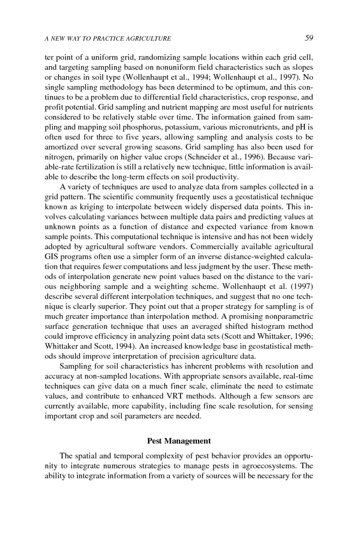
FIGURE 2-1 Crop yield and profit maps. A. Raw yield as measured on average over 25 × 25 meter cells. B. Profit variability within the field. Profit for each cell is calculated using the yield for that cell and production cost estimates for irrigated corn in North Texas. Conventional management was used over the entire field. The images above were collected from an irrigated corn field in the panhandle of Texas. The yield variability is extreme, compared to other fields in the area. However, it does document the yield and profit variability that can be found in the producer's fields. SOURCE: Maps developed by Stephen Searcy, Texas A&M University.


|
graphs from remotely sensed vegetation indexes has the potential to better inform growers of the approaching harvest date. Within the field, relative differences in the vegetation index can show whether a crop is developing uniformly at any one time or over the growing season. The aerial image shown is a computer enhanced green vegetation map of a 140-acre cantaloupe field. Ten meter resolution aerial images of the field have been acquired eight times over the summer. Data collected from sites with varying levels of crop growth have been extracted from the images to show the pattern of their development (see graphs Changes in Crop Growth). The graphs illustrate how seasonal progression in crop canopy growth can be tracked for five sites that initially are at different growth performance levels (i.e., 20 percent initial greenness). Changes in the growth rates of each site are seen clearly as are changes in the relative ranking late in the season of sites at 80 percent and 60 percent initial greenness. The crop relative growth rate declines when the growth shifts to fruit production. Superimposed on the crop development graphs are key dates showing the relationship between crop condition and management decisions. Seasonal changes in plant cover and biomass can be linked to predictions of future crop growth, harvest timing, and yield estimates. When these kinds of data are used in a crop production model it can assist in farm management decisions. This capability will be important in irrigated agriculture as producers could manipulate water inputs or fertilizers to advance or slow down crop maturity. The ability to follow changes in crop development for specific field locations is an emerging area of precision agriculture. |
Precision agriculture strategies attempt to adjust field practices to accommodate known variability of important factors. As practiced today, precision agriculture is primarily based on a few parameters, such as soil nutrients or weed maps. Understanding the impact of multivariate interactions is a challenge to both producers, consultants, and scientists. The amount and complexity of available information has increased at a phenomenal rate. Growers will have access to large databases, but the ability to extract useful information will have to be developed. Agriculturists may find themselves uncertain about what information to use and how it can add value to production systems.
Systems Approach
Crops are integrators of the biophysical environment within a field. Crops express their genetic potential and reaction to local soil, pest, and climatic conditions
through the quantity and quality of harvested product. Interactions occurring among these agronomic factors affect crop performance; for instance, weather conditions favoring growth of an insect vector can lead to outbreaks of viral diseases, resulting in damaged crops. A systems approach to agronomic management considers multiple interactions occurring in an agroecosystem (National Research Council, 1989, 1996b). Manipulating agroecosystems to achieve greater productivity depends on an understanding of the relationships among agronomic factors. The potential for generating large, detailed data sets presents a challenge for agricultural scientists who are developing tools to further the understanding of those interactions and their effects on yield. Agricultural scientists can use data sets generated under experimental conditions, as well as those generated by producers in attempting to understand the interactions in cropping systems. The adoption of precision agricultural management is most likely to occur for those factors and interactions for which there is enough understanding to accurately predict the outcomes and economic value of actions to manipulate the crop in its agroecosystem.
Mapping spatial yield patterns is a logical step in visualizing field variability. However, a yield measurement in itself cannot explain the cause of variation. Information is more valuable when causal relationships can be determined between various data sets describing a field. Yield maps can be superimposed on maps of other data collected from the same location. The analysis of these data layers with a GIS and other analysis tools may reveal spatial relationships among agronomic components contributing to yield variation (Skotnikov and Robert, 1996).
Spatial and Temporal Variation
The most significant impact of precision agriculture on crop production systems is likely to be on how management decisions are made and on the time-space scales that are addressed, not on actual production practices. Precision agriculture techniques may increase efficiency of input use by allowing the producer to manage the crop on both a spatial and temporal basis with prescriptive rather than prophylactic treatments. The management of a crop production system involves many decisions, all of which are interrelated and ultimately affect profit. Crop production is subject to uncertainty due both to stochastic processes (primarily weather) and to unmeasured variability in agronomic conditions (i.e., soil fertility). Precision management tools may improve decisions related to site conditions, thereby reducing this aspect of uncertainty in the management system. However, the performance of precision agriculture depends on the interaction between site conditions and stochastic factors. Stochastic factors such as weather often have a greater impact on yield variability than variations in soil productivity. For example, a study comparing variable-rate and uniform application of superphosphate on narrow leafed lupine (Cook et al., 1996) found that variable-rate application based on nutrient response curves estimated using data from a single
year performed poorly because the estimated nutrient response function did not take variability in weather conditions into account adequately. Other studies have similarly shown low correlation between yield and applied fertilizer when weather conditions and other important factors are not included in nutrient response modeling (Huggins and Alderfer, 1995). If subfield management is to be successful, it must be based on techniques that encompass the simultaneous effects of the most important factors influencing yield, rather than individual factors taken in isolation. For example, successful variable-rate application strategies will likely be based on nutrient response curves that incorporate soil characteristics, weather conditions, and other factors in addition to applied fertilizer.
The ability to respond to changing production conditions is likely to be as important as understanding variability in beginning-of-the-season production conditions (i.e., in soil productivity). Farmers make judgments on input use conditional on likely yields for a field given anticipated weather conditions. This balance between anticipated income and expenditure on inputs is subject to considerable uncertainty. Precision agriculture techniques that allow the producer to manage initially for a lower yield goal and still respond to seasons in which yield potential is greater than normal could substantially ameliorate the effects of that uncertainty. Such an ability to respond to temporal variability would be particularly desirable for handling weather-related risk. For non-irrigated production areas, perhaps the greatest threat to crop production is lack of sufficient moisture to mature the crop. Low soil moisture often causes farm managers to opt for lower initial chemical and fertilizer application rates and thus forego additional crop production should weather conditions turn out more favorable than anticipated. Similar situations occur when the potential for leaching in light sandy soils limits the amount of nitrogen that can be applied in a single application (Booltink et al., 1996).
Precision management systems can be envisioned that could respond to the yield potential of the crop as it varies within the growing season. This more reactive approach to spatially and temporally variable conditions will depend on the ability to economically assess the need for and delivery of production inputs. Crop status data and predictive models that could accurately estimate yield several weeks or months before harvest could improve marketing decisions. A current example of this capability is the use of cotton growth modeling. Cotton phenological development assessments and historical weather data have been successfully used to predict lint yield during the growing season (Landivar and Hickey, 1997; Plant et al., 1997). An indeterminate crop such as cotton lends itself to in-season management, as the plant will put on fruit that will never result in mature lint. Early knowledge of yield potential could affect financial decision making related to inputs (whether to apply crop protection chemicals) and marketing (adjustments of forward contracts). While cotton growth modeling has been done on a whole-field basis, its predictive capability may be improved with the intensive data sets that result when using subfield management (Landivar and
Searcy, 1997). Producers face many factors that can be managed or will affect management decisions. The complete realization of precision agriculture's potential may depend on development of predictive crop models that can vary and co-vary the manageable factors on a specific farmstead. It is unclear whether such an approach will rely on detailed mechanistic models, models based on a wealth of data generated for a given farmstead, or a hybrid of these two approaches.
MANAGEMENT FACTORS
The management factors in a precision agriculture system are essentially the same as those in a conventional crop production system. Producers can control some of these factors and can only react to others. Factors such as nutrient management have been emphasized in the development of precision agriculture whereas others, such as pest management, have received relatively little attention. Management factors can be subdivided into two groups: those that can be managed with today's technologies and those for which new management methods are promising but require further development. However, because precision agriculture methods are still developing, all factors will likely experience advancements and improvements.
Precision agriculture is based on the availability of intensive data about important agronomic indexes. The process of obtaining these data has a cost and, at least for some factors, the greater the data requirements, the greater the cost. As a result, producers and their advisors must decide how detailed the required data should be. The practicality of the data often depends on how long the information has value in management decisions. Indexes such as soil type and topography have long-term usefulness. The investment in obtaining this information will have returns for many growing seasons. Factors such as nutrient availability (except nitrogen), soil-borne pathogens, and perennial weed infestations may exhibit intermediate usefulness because they change slowly. Available soil moisture, nitrogen availability, and insect pressure are examples of short-term dynamic indexes. The accuracy of the information about any of these factors degrades over time and may be thought of as having a half-life. Cost-benefit analysis could be used in precision agriculture by considering the half-life of the information, the potential returns from its use, and the cost of obtaining and analyzing it. However, the half-life of agronomic indexes can only be estimated.
Methods of adding value to data sets also have potential, and are in need of study. For example, spatial data on soil variation could be used to regulate fertilizer requirements, but also may be useful in regulation of herbicide rate and for directed sampling of pest distributions (Fleischer et al., 1997; Johnson et al., 1997). Recent studies have shown that targeting of sample sites based on other known characteristics of the field (typically topology and soil type changes) can result in more accurate maps, often with fewer samples (Hollands, 1996; Wang et al., 1995).
A precision agriculture approach to crop management requires producers to consider information about production units in the same manner as production inputs such as fertilizer or irrigation. As the technologies for measurement of important agronomic indexes improve, producers may have to evaluate precision management for all aspects of production systems. The following sections attempt to briefly address the potential for precision management strategies for factors that impact crop production. Each section deserves a detailed examination, but the intent here is to highlight possibilities, while leaving the in-depth examination to others.
Crop Genetics
Crop productivity depends on the genetic makeup of the plant variety and the response of the variety to its environment. Varieties are selected for particular genetic traits (i.e., drought tolerance, resistance to diseases and insects, and yield). In a precision agriculture scenario, producers try to match crop variety and populations with various conditions that exist in a field. The introduction and maintenance of transgenic varieties requires sophisticated management techniques. For example, the use of Bt-enhanced seed varieties (cultivars engineered to contain Bacillus thuringiensis, a bacterium that produces a protein toxic for insect pests) requires the planting of nontransgenic varieties in refuge areas to avoid the development of resistance. The requirements for refuge areas vary with the intended management practices, and precision agriculture techniques may predict the optimum location for each variety.
Similar potential exists for the use of herbicide-resistant varieties. If there is a yield penalty associated with the varieties containing the herbicide-resistance gene, the producer may wish to plant that variety only where weed problems exist. Variable-rate technology planters can change the variety being planted in each portion of the field. However, if resistant and non-resistant varieties are mixed in the same field, the planting sites for each would have to be recorded and used in any subsequent herbicide applications in order to ensure that susceptible plants are not sprayed. Changing varieties to manage for drought-prone soils has also been proposed.
Plant Population
Knowing when to change the plant population density for optimum yield in fields with known variability would benefit a producer and could be done by varying the seeding rate on a planter or grain drill. Preliminary data indicate that a positive net return can be achieved by varying plant population according to depth of topsoil (Barnhisel et al., 1996). If a producer expected fair-to-poor conditions for germination and emergence of seeds on productive soils, the seeding
rate could be increased. Competition from weed pressure may be reduced by increasing the seeding rate at planting (Mortensen et al., in press). Increasing the seeding rate in small-grain crops in California can help control Johnson grass and smart weed. Plant population data could also be used to check on the effectiveness of precision planters that drop seeds at a set spacing up the row, which is an important manageable factor when expensive hybrid seed is used. Improved knowledge of field conditions and pest pressure can help a producer make planting decisions.
Although seeding rates can be adjusted at planting, many factors can affect the plants throughout the season. Varying seeding rates may not necessarily result in an expected plant population distribution. Knowing the actual plant population at harvest time is important in interpreting yield maps and for management decisions made throughout the growing season. Technology currently under development for corn in the Midwest will measure variability of a plant population and plant spacing (Birrell and Sudduth, 1995; Easton, 1996; Plattner and Hummel, 1996). Information gathered across a field will generate a data layer that can be compared with yield maps, desired seeding rates, or weed maps. These devices are still in the developmental stage but illustrate the potential for using sensing techniques to gather useful information as a part of normal field operations such as cultivation or harvesting.
Soil Variability
Soils vary significantly as a result of regional geological origins and past and present cultural practices. At the highest level of resolution, soil physical, biological, and chemical properties vary vertically, horizontally, with treatment, and with time. For example, variable distributions of soil nutrients in fields may result from improperly adjusted mechanical application equipment (Bashford et al., 1996; Olieslagers et al., 1995). In other cases, past practices, such as an old feedlot, can generate local pockets of higher organic matter producing healthier plants than surrounding areas. Thus, natural variability patterns and management practices need to be considered in assessments of soil spatial variability.
Soil layers that restrict rooting depth are a major concern in many areas. Electromagnetic induction techniques have been used to assess the presence of and depth to claypan layers (Doolittle et al., 1994). Limited work on assessing soil compaction has indicated a potential profitable return to site-specific tillage operations instead of whole-field subsoiling (Fulton et al., 1996). Soil physical, chemical, and biological properties have dramatic effects on crop production. However, only a few commercially available sensors can assess these properties in the field. Practitioners are limited to sampling and laboratory analysis for determination of in-field variability, which is costly and time consuming. The number of commercially available sensors will be a limiting factor for precision agriculture in the immediate future.
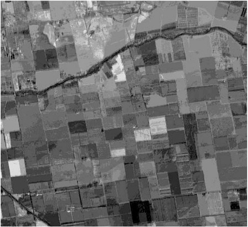
FIGURE 2-2 Soil and crop variability observed in remote sensing. This image was acquired over fields in the Sacramento Valleys near Davis, California by a NASA airborne sensor on August 20, 1992. The area has diverse crops from fruit and nut orchards, tomatoes, corn, alfalfa, and safflower growing on deep loam soils. At this time many of the summer crops have been harvested and soil variation within and between soil units is evident. Despite the low spatial resolution needed for many precision agriculture applications (about 20 m by 20 m, or 400 m2), relative to new spaceborne sensors that can provide 1-5 m resolution, the connection between some soil patterns and apparent crop growth differences is evident in the fields. Non-uniform growth conditions within fields are common. SOURCE: Data acquired by NASA Advanced Visible Infrared Imaging Spectrometer (AVIRIS) and processed by University of California, Davis Center for Spatial Analysis and Remote Sensing (CSTARS).
Soil Fertility
The concept of using information about variability to manage specific sites in a field is not new. Farmers of ancient times were keen observers of crop performance and recognized benefits from spreading different amounts of manure and liming materials on different kinds of soils (Kellogg, 1957). In the 1620s, colonists observed site-specific fertilizer practices of Indian farmers who placed fish directly at the roots of each corn plant. In 1929, researchers Bauer and Linsley suggested marking a field in 3-foot pace intervals in the north-south and east-west directions to determine field position for variable application of limestone materials (Goering, 1993). Today's information technologies have the potential to generate more sophisticated assessments and responses to within-field heterogeneity and variation in soil fertility.
Uniformity trials have been used to study soil heterogeneity by simply planting a crop that was uniformly managed throughout the growing season. The field was divided into small segments and crop yield was measured on each segment. Crop yield variability among segments was the measure of varying levels of soil fertility in the field. Crop yields obtained from a uniformity trial were plotted on a map, and field segments having similar yields were connected by smooth lines. These yield maps were interpreted as soil fertility contour maps. LeClerg et al. (1962) made two general conclusions from these early uniformity trials:
-
Soil fertility variations are not distributed randomly but are to some degree systematic; that is, contiguous field segments are more likely to be alike than are segments separated by some distance.
-
Soil fertility is seldom distributed so systematically that it can be described by a mathematical formula.
A common strategy in soil fertility management is to match fertilizer inputs with crop needs. The goals of this mass balance approach are to increase nutrient uptake efficiency and minimize fertilizer losses. Fertilizer rate recommendations for immobile nutrients (i.e., phosphorus, potassium, and zinc) are based almost entirely on soil test levels calibrated for a specific crop, soil type, and climate. Nitrogen fertilizer rates are based on estimates of yield potential (average or spatial) with corrections or credits for nitrogen in soil profile, legume, manure, and soil organic matter sources. Recently, producers have been encouraged to adjust timing of fertilizer applications to reduce environmental risks. For example, nitrogen losses due to leaching can be reduced by minimizing the time between application and plant uptake (Killorn et al., 1995). Conventional approaches to soil testing based on averages are inadequate for characterizing temporal and spatial variation of soil properties.
The most widely used precision agriculture technique is probably the management of soil nutrients and pH. Precision management of soil nutrients can increase profit in two ways. The first is improved crediting of residual nutrients
|
BOX 2-2 Site-Specific Forestry Management Modern forestry practices require extensive harvest planning to maximize or optimize harvesting while maintaining yields from forests over many decades. Forest management today must consider forest ascetics and scenic vistas, historic and archeological sites, competing uses for recreation, grazing, and other extractive uses like harvesting for mushrooms, medicinal plants, ornamentals, and mining of mineral deposits. Many forestry companies have adopted the use of models within a GIS to aid in site-specific management of forest resources. The economic value of forest products is sufficiently high to justify extensive use of site-specific technologies. Management plans include decisions about modes of logging, such as by helicopter, tower, line, or chain, which depend on topography, stand condition, and distance to roads. GPS is used by timber cruisers to identify specific trees for harvest and locations of harvested trees are entered into the GIS database. GIS is used to predict the potential for soil erosion after logging, especially if the site is close to a stream, and to develop mitigation strategies. This allows erosion models based on actual soil characteristics, topography, and site conditions (i.e., cover type) to be used in developing spatially explicit erosion hazard estimates over the site rather than arbitrary rules like distance to roads or streams. Evaluation of off-site nutrient and herbicide transport are other concerns. Fire hazard is another risk factor that can be minimized using spatially explicit models for site management and mitigation. Fire risk and fire hazard models require a digital terrain model, information about the fuel load and its vertical and horizontal distribution, and weather information. Foresters may also use site-specific forest mensuration models to predict tree growth that consider site-specific soil fertility and moisture |
remaining in the soil after a crop is harvested. This works best for less mobile soil chemical properties such as phosphorus and potassium concentrations or pH. Nitrogen is more mobile and requires more frequent sampling to assess the appropriate credit levels. Nitrogen remaining in the soil after harvest may be available to the next crop, unless temperature and rainfall conditions result in leaching or volatilization. More accurate crediting of residuals can reduce costs and environmental load where overapplications would have occurred, and can improve yields for locations that would have been undertreated. Second, precision management of soil nutrients allows the producer to set variable yield goals for fields that do not have a uniform productive potential. With variable yield goals, inputs for a
|
conditions, and microclimatic differences. Dynamic growth models of varying complexity aid in developing a long-range yield plan for a site. Annual remote sensing images, like LANDSAT Thematic Mapper and aerial photography are frequently used to assess reforestation success, erosion, competition from shrubs, and tree mortality. This use is predicted to increase as the next generation of satellites becomes available. The new satellites will permit information extraction about canopy condition beyond properties related to total foliage display. High spatial resolution radar, LIDAR (an acronym for light detection and ranging), and optical sensors will obtain information about forest structure and biomass distribution. More frequent temporal coverage will permit earlier detection of insects and other environmental stresses. Many charismatic, endangered, and sensitive wildlife species require forests with late successional structural features to provide forage, nesting, and perching locations. Forests with standing and down dead trees, open gaps and spatially distributed forest patches, corridors for migration, vertical and horizontal crown complexity, and other pattern features may be mapped and tracked in a GIS. In addition, GIS based models using remotely sensed information provide a mechanism for evaluating the impact of site-specific logging on wildlife habitat conditions necessary for protection of these species. Other forestry applications for site-specific methods include mapping the spread of insects and fungal pathogens, to regional impacts of air pollution, like acid deposition and ozone, on forest health and species specific mortality. As competing demands for conservation, recreational use, and economic extraction increase, GIS databases, using GPS linked site data, and remote sensing monitoring, offer the hope that site-specific methods can be used to optimize management decisions. |
specific area of the field can be matched with the expected yield, and supplied at a more economically optimal level (Hergert et al., 1997). Additional on-farm research is necessary to determine the economic returns from different approaches to soil fertility management in precision agriculture.
The evaluation of soil nutrient levels across a field is typically performed by taking soil samples, analyzing them for nutrient content, and interpolating values between the sampling points (Wollenhaupt et al., 1997). Figure 2-3 shows a field with the sites where soil samples were taken, and a resulting interpolated phosphorus map. The actual values for soil phosphorus concentration are known only at the sampled points; all other values are estimated. Both the method used for

FIGURE 2-3 Map of soil test phosphorus. This figure shows a field with the sites where soil samples were taken and a resulting interpolated phosphorus map. The actual values for soil phosphorus concentration are known only at the sampled points. All other values are estimated. Both the method used for locating the sample points and the interpolation methods are important to the accuracy of application maps that might be derived from such a layer. SOURCE: Stephen Searcy, Texas A&M University.
locating the sample points and the interpolation methods are important to the accuracy of application maps that might be derived from such a layer.
Although procedures vary with the supplier, many fields have been grid sampled to determine nutrient levels. Grid sampling involves overlaying a grid on the boundaries of a field; the grid spacing used may be uniform or may have a wide range of resolutions. Soil properties can vary at any level of resolution and with sampling date. Because inherent field variability is not well understood, determination of grid resolution has been based mostly on costs. Obtaining and analyzing soil samples is expensive; thus, the number of samples included in the grid is based on the potential return from improved nutrient management. For example, one sample may be collected from a 10-acre field of grain, whereas two or more samples may be collected from each acre of a higher value crop such as potatoes.
The sampling techniques used are determined by the type of data analysis to be performed. Suggested sampling techniques include taking samples at the center
point of a uniform grid, randomizing sample locations within each grid cell, and targeting sampling based on nonuniform field characteristics such as slopes or changes in soil type (Wollenhaupt et al., 1994; Wollenhaupt et al., 1997). No single sampling methodology has been determined to be optimum, and this continues to be a problem due to differential field characteristics, crop response, and profit potential. Grid sampling and nutrient mapping are most useful for nutrients considered to be relatively stable over time. The information gained from sampling and mapping soil phosphorus, potassium, various micronutrients, and pH is often used for three to five years, allowing sampling and analysis costs to be amortized over several growing seasons. Grid sampling has also been used for nitrogen, primarily on higher value crops (Schneider et al., 1996). Because variable-rate fertilization is still a relatively new technique, little information is available to describe the long-term effects on soil productivity.
A variety of techniques are used to analyze data from samples collected in a grid pattern. The scientific community frequently uses a geostatistical technique known as kriging to interpolate between widely dispersed data points. This involves calculating variances between multiple data pairs and predicting values at unknown points as a function of distance and expected variance from known sample points. This computational technique is intensive and has not been widely adopted by agricultural software vendors. Commercially available agricultural GIS programs often use a simpler form of an inverse distance-weighted calculation that requires fewer computations and less judgment by the user. These methods of interpolation generate new point values based on the distance to the various neighboring sample and a weighting scheme. Wollenhaupt et al. (1997) describe several different interpolation techniques, and suggest that no one technique is clearly superior. They point out that a proper strategy for sampling is of much greater importance than interpolation method. A promising nonparametric surface generation technique that uses an averaged shifted histogram method could improve efficiency in analyzing point data sets (Scott and Whittaker, 1996; Whittaker and Scott, 1994). An increased knowledge base in geostatistical methods should improve interpretation of precision agriculture data.
Sampling for soil characteristics has inherent problems with resolution and accuracy at non-sampled locations. With appropriate sensors available, real-time techniques can give data on a much finer scale, eliminate the need to estimate values, and contribute to enhanced VRT methods. Although a few sensors are currently available, more capability, including fine scale resolution, for sensing important crop and soil parameters are needed.
Pest Management
The spatial and temporal complexity of pest behavior provides an opportunity to integrate numerous strategies to manage pests in agroecosystems. The ability to integrate information from a variety of sources will be necessary for the
pest management decision-making process. With the state of precision agriculture technologies today, site-specific pest management is limited to less mobile pests, such as weeds. Insects are difficult to characterize in a timely and economic manner. Because insect populations can change rapidly in a few days, the half-life of data on insect densities would be short.
The complex nature of pesticides and their use in the environment creates a need for information and guidance in the decision-making process. The safety and regulatory aspects of pesticide use have placed a monitoring and reporting burden on producers in some agricultural production regions that is most easily managed with a GIS database and automated recording of applications. Improved pest management is likely to increasingly use precision agriculture technologies, with potential benefits to farm workers, the environment, and our food supply.
Pesticide Management
Producers are interested in saving on input costs and applications. Environmental improvements may be derived by reducing pesticide use through precision application of chemicals only to areas with pest infestations instead of treating entire fields at uniform rates. Results of analyses of weed populations in 12 Nebraska fields show that postemergence herbicide applications could be reduced 71 percent for broadleaf weeds and 94 percent for grass weeds if only infested areas were treated (Johnson et al., 1997). Weed seedling density varied from 10 to 41 seedlings per meter of row length on fields with low to severe weed infestations. Associated crop losses varied from 20 to 43 percent. The authors estimate that herbicide use could be reduced 30 to 72 percent if real-time sensing and discrimination of weed species could be accomplished. Such site-specific determinations for spraying could also increase crop yields when whole-field spraying is not justified because average weed infestation is below the economic threshold.
Precision agriculture techniques can aid in making decisions on the rate of pesticides applied across a field. Detailed field maps can identify soils that are prone to leaching problems. Many agricultural chemicals, especially pre-emergence herbicides, are labeled for different application rates based on soil conditions. Soil texture and percentage organic matter are important for identifying the correct application rate of these materials. An example of this is trifluralin (Treflan), which has different rates for three different soil texture classes: coarse sand (light soils), silt (medium soils), and fine clay (heavy soils). The lowest rates are for the coarse sandy soils that are more apt to leach materials.
Pest control is an area for which both the spatial and temporal aspects of precision agriculture could contribute to environmental improvement. Pests could be managed not only by specific areas but also by timing treatment according to damage thresholds arrived at by integrating scouting reports, remote sensing, and on-the-go sensor input; rather than by using fixed prophylactic treatments.
Although spot treatments to target pests may reduce pesticide use, there is little evidence that this management strategy is profitable after the cost of obtaining the pest density data is included. An increased understanding is needed of the cost effectiveness and social benefits from managing pests with precision technologies.
Farmworker Safety
The use of differentially corrected GPS (DGPS) may reduce pesticide handler exposure to toxic pesticides. For aerial applications of pesticides, pilots formerly depended on pesticide handlers on the ground to guide them across fields to be sprayed. With DGPS technologies, pilots can substitute instrumentation for human labor to maintain proper patterns of application. Pesticide handlers do not need to be exposed to the agrichemicals.
Weather
Weather is perhaps the dominant factor in crop production and is certainly one of the greatest sources of uncertainty. However, it is not a manageable factor. At best, producers can react to recent weather conditions and predict the effect of future weather patterns suggested by historical probabilities. Some meteorological indexes, such as temperature, humidity, and solar radiation are relatively constant over large areas or regions. Rainfall can be highly variable, even on the subfield scale. Efforts to incorporate weather data into precision agriculture techniques, especially decision-support tools, will be extremely important in attempts to understand the interactions of the many factors influencing a crop.
Suppliers
Newer satellites and Doppler radar are key components of spatially distributed weather information. The current sensors will be expanded by the addition of several new systems to be launched over the next decade, which will provide unprecedented weather information in terms of spatial detail and temporal frequency. For example, the new National Oceanic and Atmospheric Administration GOES-8 satellite obtains weather data every half-hour at a spatial resolution of one kilometer, providing an important link in making detailed, spatially distributed weather information available at the farm level. The GOES-8 satellite acquires vertical sounder data on humidity, temperature, and other properties at a spatial resolution of four kilometers. These data can be used to model regional and mesoscale atmospheric conditions to provide the agricultural community high-resolution information on current and predicted conditions. Doppler radar images are updated every 15 minutes. Many additional satellites, from both public
and private sectors, are expected to be launched over the next decade for weather observation.
The private sector has become increasingly important in the supply of weather service information to the agricultural community. Weather service providers offer satellite dishes and computer hardware and software that bring detailed, timely weather information to farms. Satellite receivers, modems, and Internet connections have brought weather data to the agricultural community in various formats, from short-range hourly and daily weather data to predictions of weather conditions spanning time periods from immediate hourly predictions through weekly, monthly, quarterly, and annual forecasts. These services are mainly focused on regional weather summaries, but customization may be possible if a market exists for field-or subfield-scale weather data. That market is not likely to develop unless precision agriculture tools are designed to include site-specific meteorological data. These services may include data inputs from weather stations established at or around farms. Automated portable weather stations with data loggers, modems, and software are commercially available for direct weather observation within the farm, but these are generally limited to one per farm.
The rapid proliferation of weather service information providers in the agricultural sector, many with on-line access, has set the stage for accessing other types of information for farm management. Providers already bundle information from public and private sources and combine weather data with crop models to provide specialized data and services to their agricultural customers. Access to real-time information via satellite links allows producers to use the information without significant investments in expensive computer hardware and software and without substantial time investments in processing raw data to obtain desired information. Use of these services may spur the adaptation of other site-specific technologies.
Monitoring Precipitation
Precipitation is the primary weather index watched by most producers. Satellite images, Doppler radar, and interpolated weather station data are being used to create county-and field-level rainfall maps with updates every 15 to 30 minutes; the updates allow a producer to watch an approaching storm front as it moves into and across a region. For precision agriculture, estimates of subfield rainfall amounts would be of great value.
Relative Humidity
Humidity readings are especially important for forecasting the infestation and spread of fungal pathogens, such as downy and powdery mildew. Humidity is also important in biological control programs for monitoring conditions favorable
for introduction of beneficial insects and mites. Daily humidity maps are among the products offered by weather information suppliers.
Harvest
Many management factors associated with harvest affect both the quality and quantity of marketable product. Precision agriculture harvesting techniques have been focused on quantitative measurements (yield and moisture content). The yield data obtained during the harvest operation are a critical input to any precision management system. However, data sets that describe subfield variation of crop development also have other implications. Producers must be concerned with the quality aspects of their products. Product quality can be as important a determinant of profitability as quantity.
In the future it may be possible to map product quality as well as yield. Real-time quality sensors do not exist, but predictive crop models may be a substitute. If crop growth models can use subfield-scale data to predict product quality, a producer may be able to avoid harvesting a portion of the field, for example, that has a high probability of containing aflatoxin. If a cotton field has areas with significant differences in lint quality, the producer may choose to operate the pickers so that the cotton would be placed in modules with more uniform qualities. With sufficient knowledge of the product quality, GIS and differential global positioning system technologies could be used to schedule harvest operations to optimize marketing opportunities.
Marketing
Marketing is often considered to be the most important factor in the profitability of agricultural production. Precision agriculture techniques have not yet been developed to the point of significantly affecting crop marketing decisions. However, the availability of a detailed data set that describes the growing conditions and all chemical applications used in the production of a crop can have economic value. Product identity and documentation can be particularly important for products intended for human consumption. The use of detailed data sets to predict yields several weeks in advance of harvest would be of great value in a marketing plan that uses forward contracting or options. The communication technologies associated with precision agriculture could potentially provide marketers of agronomic products more complete information on market trends.
SUMMARY: EFFECT ON MANAGEMENT
The previous sections have described the various ways in which precision agriculture will affect crop management. Some of the practices described are based on documented experiences with these new technologies. Others are the
committee's best guess at future developments and their results. It is likely that some predictions may be wrong, others may be technically possible but will never become economically feasible, and unforeseen tools, techniques, and applications will be developed. Regardless of the accuracy of our vision, the crop management practices of the twenty-first century will be significantly affected by these information technologies.
Crop yields typically represent only a small portion of the genetic potential of the plants. The loss of yield potential is attributed to the many limiting factors that can affect a plant during its life. The previous sections have described some of those factors, and the decisions that producers can make over the course of a cropping season. Precision agriculture has the potential to affect crop management practices by reducing or removing the effects of limiting factors. It seems clear from the evidence to date that precision agriculture technologies will be used in the management of some factors for some crops in some regions. Major limitations to adoption in a broader range of cropping systems include an incomplete understanding of agronomic parameters and their interactions, the cost of obtaining site-specific data, and a limited ability to integrate information from sources with varying resolutions and timing. There are many possibilities for incorporating detailed information into management decisions. The realization of those possibilities will depend on creative scientists and engineers inventing and improving the tools of precision agriculture.