The Silent Landscape: The Scientific Voyage of HMS Challenger (2003)
Chapter: The Restless Earth
The Restless Earth
Gibraltar, Mediterranean Sea, January 23, 1873, 36° 09′ N, 05° 21′ W to Station 19, Western Atlantic, March 3, 1873, 19° 30′ N, 57° 35′ W
ATLANTIC TRANSECT
HMS Challenger left Gibraltar on January 23, 1873, and finally headed out into the true unknown, the deep Atlantic Ocean. As the continental shelf dropped away beneath her, and the fans of mud from the rivers of Northern Europe gave way to the unchanging vastness of the Atlantic abyssal plain, the crew settled into a routine of sounding and dredging operations that would govern all their days for the rest of the voyage. The ship’s company rose at 4 A.M. and, on standing orders from Challenger’s two staff surgeons, swabbed the decks with copious quantities of seawater. The emphasis on hygiene, like the daily ration of lime juice and the improvements in discipline were all part of the navy’s new recognition of the importance of morale. And although the bluejackets might complain at the extra work involved in the daily swabbing of the decks, they, too, recognized its importance and so they did it well. Legends of the navy only 60 years before, when impressment was still the norm and men did not see their families for years on end, as well as the terrible privations suffered by sailors during the Crimean War, were still too fresh for the new sail-and-steam navy not to appreciate the reforms.
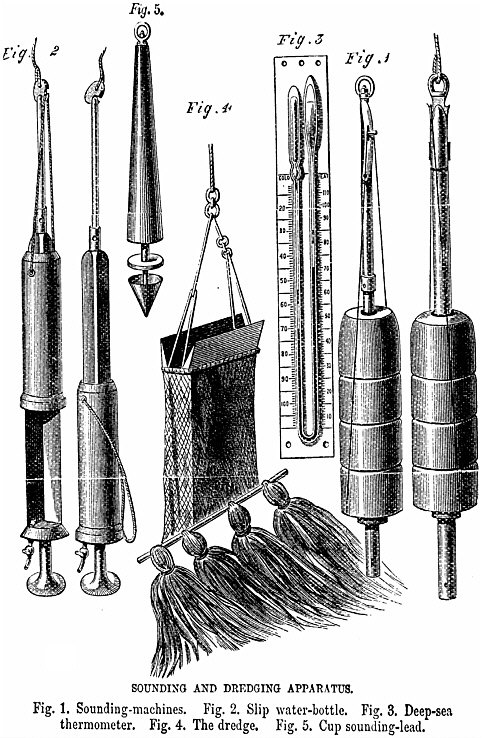
The washing down of Challenger was followed by the tidying of the sleeping quarters; hammocks, sheets, and blankets were all stowed neatly. At 6 A.M. there was a simple breakfast of biscuit and cocoa and then all hands started preparations for the day’s dredging and sounding operations, furling the sails while William Spry and his mates made steam down below in the engine room. It was essential to use steam power while dredging and sounding, because only with a consistent push from the propeller could the attitude and position of the ship be kept constant. Under sail she would drift miles off-station, but with the steam engine churning and her bow head-on into the sea, enough way could be put on to achieve a stable position from which the sounding line—a rope of woven piano wire—could be run out. But sounding by Challenger, unlike most conventional sounding aboard Victorian men o’war, was more than just an exercise for determining the depth of the ocean. Attached to the sounding wire were various instruments by which the silent landscape—and its watery atmosphere—could be probed. There were three main types of instrument: thermometers for measuring the water temperature at the seafloor (as well as at various depths in the ocean), specially constructed flasks for taking samples of deep and bottom waters, and a device for retrieving sediment from the seafloor itself.
All of these instruments were marvels of Victorian ingenuity and the thermometers and water samplers were just as extraordinary as the sampling devices described in the first chapter of this book. The thermometers were of the maximum and minimum kind originally invented by James Six in the eighteenth century and are still known by that name today. They were used to measure the highest and lowest temperatures encountered in the long drop to the sea bottom and were in all respects identical to those used today in garden greenhouses, except that they were heavily armored against the crushing pressure of the deep ocean. They consisted of a
curved U-tube filled with mercury attached to a bulb containing creosote.
The expansion or contraction of the creosote moved the curved U of mercury around in the two arms, and as each limb of the mercury column moved, it pushed a small spring-loaded metal index in front of it. The base of each index—that is, the end nearest the mercury—then stayed in place as the mercury moved away again. Thus, the highest and lowest temperatures were preserved for Challenger’s scientists to log when the thermometer was hauled up again.
The water-sampling flasks were of two varieties: one constructed to sample bottom waters and the other to take samples at different depths. The bottom-water sampler was a slender, reinforced rod with finely machined discs of brass at either end. A sleeve above the upper disc was attached to a lanyard so that when the bottom was finally reached, the lanyard disengaged a clutch that allowed the sleeve to slide down the rod, trapping a sample of bottom water between the two discs. The intermediate water sampler was similarly constructed but had two valved stopcocks at top and bottom through which water flowed freely as the device descended, but which snapped closed as soon as the line was hauled upward. In this way these devices could be lowered to a predetermined depth and then used to trap water from that depth.
The thermometers had their limitations. Although the bulbs supposedly compensated for variations in pressure by enclosure in a second bulb full of alcohol, the accuracy of the pressure compensation was something of an unknown. Also, the long journey through the water column and the emerging realization that temperature did not decrease in a straightforward manner with depth meant that the maximum and minimum temperatures registered were not necessarily those of surface waters and sea bottom, respectively. To minimize this problem it became routine aboard Challenger to deploy the line again after the initial sounding, this time with
thermometers arrayed every hundred fathoms to try to chart more accurately the change of temperature with depth.
The whole complex apparatus was rounded off by the sediment sampling apparatus that dangled at the bottom of the rope and was supposed to retrieve a sample of the seafloor for later study aboard the ship. Even this technique was not straightforward, because the crew had to know when the sounding line had reached bottom and once the line was in the water there was no way of telling whether it was vertical beneath the ship’s keel or drifting off at an unknown angle under the influence of some deepwater current. The answer to this problem was simplicity itself. The sounding wire was calibrated in increments of 25 fathoms: 100-fathom marks being blue, 50-fathom marks red, and the 25- and 75-fathom marks white. As the line was fed out, the time taken for successive markers to pass over the side increased proportional to the drag of the line. When the time taken for the fathom markers to pay out departed from this precise relationship—the winchman had a book of tables that informed him—the bottom of the ocean had been reached. The crew then pulled in the line, carefully read and noted the thermometer readings, sent the water flask down to Buchanan’s physical laboratory where its specific gravity and other physical properties were measured, and sent the contents of the sounding rod to the natural history laboratory where the composition of the ocean floor was noted and the sediment or rock sample dried and bottled. Figure 4 shows the Challenger sounding and dredging apparatus. Then, the second deployment—to measure the temperature of the ocean at different depths—was tackled. And all this before the day’s quota of dredging action had even started!
At last the Scientifics were in their element! During the first days out of Portsmouth they had found, as William Spry reported, “the etiquette and usages of naval everyday life . . . particularly vexatious and annoying” but with the subtropical weather now set fair and some real science to do, they were at last engaged in what they had come for. But for the crew and the ratings aboard the ship
life was not quite as sunny. The constant stop-and-measure of the Challenger expedition was quite at variance with what they were used to as military men when the emphasis was on arriving at one’s destination with dispatch. Even Captain Nares who, as an Arctic explorer, was accustomed to the methods of science, must have found the drudgery wearisome.
Joe Matkin was getting used to his quarters below decks in an issuing room that was not nearly as comfortable as the one that he had enjoyed aboard Audacious, because on Challenger it was below the water line and suffered unbearably from the poor ventilation. Also it was so small that there was no room for a seat, so he had to write his letters standing up. These hardships were an additional burden to a young man who was already worried about his father’s failing health—and it didn’t help either that in Madeira he had witnessed no less a personage than the Mayor of Edinburgh comfortably overwintering in the subtropical balm for the sake of his own sickly constitution.
The expedition plan called for a transect of the deep Atlantic, with attendant temperature readings and seawater sampling, from Santa Cruz in Tenerife to Sombrero in the Virgin Islands. They planned to take soundings every 120 miles and dredge every 300 miles, so a total of 22 soundings and 13 dredgings were forecast for the entire 2,700-mile trip across the Atlantic. In preparation, Challenger took on 25 tons of coal at Santa Cruz. This port was where Nelson lost his eye but, as Joe Matkin wryly reflected, a modern ironclad could knock the place to ashes in about two minutes. And it was at Santa Cruz that death very nearly visited Challenger again: One of the boys fell from the rigging, a height of almost 40 feet into the sea, and but for the quick action of an able seaman he would surely have drowned.
On the evening of Friday, February 14, Challenger left Santa Cruz. The weather, notes the expedition report, was “bright and pleasant, with a light breeze blowing from the northeast.” For the first 250 miles west of Tenerife the ocean bottom was found to be
nearly level at a depth of about 2,000 fathoms, consisting for the most part only of Globigerina ooze (of which more later) but only 50 miles further to the west the depth of the ocean shoaled suddenly to only 1,500 fathoms and the nature of the ocean bottom changed dramatically.
METAL PEARLS OF THE DEEP
On Tuesday, February 18, 1873 Challenger hove to some 160 miles southwest of the tiny island of Ferro (part of the Canaries) at a site designated by Wyville Thomson as Station 3 of the Atlantic transect. The soundings indicated a modest depth of only 525 fathoms and there was no expectation of anything out of the ordinary when the dredge was sent down at 10 o’clock that morning. As always, the dredge took an age to reach the seafloor and, after the usual several hours of towing under steam, yet another age before it reached the surface again, finally arriving back at 5 o’clock in the afternoon. It was just another routine chore in what, it was becoming clear, was going to be a long series of such chores and more than one bluejacket must have already been wondering whether signing up for a three-and-a-half-year voyage of scientific discovery had been such a good idea after all. So none of them could have guessed that they were about to make one of the most momentous discoveries of the long voyage, one that would have important implications for an industrial society 140 years in the future.
When, with the evening sun already beginning to dip toward the western horizon, the dredge finally surfaced, all on board could see that within the mesh were fragments of corals that Wyville Thomson identified as members of the Corallium genus. Despite the fact that the corals were quite dead, amazingly they all gleamed with a peculiar blackish metallic luster, and at the base of each piece of coral were attached fractured lumps of brown-black rock showing clear signs of concentric laminations. Buchanan’s chemical tests showed that the peculiar luster of the dead corals was caused by a
coating of peroxide of manganese, while the blackish lumps to which they attached were apparently some form of phosphate secretion. As the ship moved on across the vast expanse of the Atlantic, Buchanan labored in his small chemical laboratory, racking his brain as he tried experiment after experiment to try to refine his assessment of these fragments.
Even Lord George Campbell momentarily forgot his lack of interest in science as he, too, was caught up in the excitement. His journal records that “. . . 160 miles to the southwest of the Canaries we found a shallow bank of 1,525 fathoms; having the day before sounded in nearly 2,000 fathoms and dredged there getting half a bag full of globigerina mud and that was all. The dredge was sent down on this bank and came up with a quantity of large dead coral, coated with black stuff, while on the branches beautiful large sponges of a new species were growing. A number of small white starfish also came up, but no mud, so the dredge must have scraped over a forest of dead coral.”
Some 1,900 miles to the west they came across another field of the strange metallic fragments. But here was a difference, because outnumbering the fragments by thousands to one were the objects from which they obviously must have originated, potato-shaped nodules ranging from walnut-size to grapefruit-size. They were strewn across the seafloor of the western Atlantic in their billions. It was incredible, it was beyond belief. What were these strange metal potatoes of the deep?
And it was at this point—some 600 miles to the east of their destination in the Danish West Indies at Station 16 of the first Atlantic transect—that the Scientifics made the connection between the black patina on the Station 3 corals and the fragments attached to their bases. Buchanan discovered that the phosphate secretions from there were as rich in manganese as the patina on the Station 3 coral fragments. The two were related—there was something in the deep that was concentrating this rarest of metals. The Scientifics also noted that regardless of size, these nodules all exhibited a char-
acteristic concentric zoning when cut in half that reminded them of how trees lay down their annual growth layers. From there it was but a small mental step to wondering whether this zoning might reflect some similar process with metals precipitating out of seawater over the course of millennia to form the concretions, perhaps akin to the way a pearl gradually builds up in layers around a tiny speck of grit within an oyster shell. “The whole question,” wrote Wyville Thomson in his account for Nature, “is a very singular one.”
Challenger’s Scientifics had discovered the first of what was destined to become a common sight for them as they made their laborious way around the world, balls of metal-rich rock that today go by the common, if inaccurate, name of “manganese nodules.” The expedition was to encounter them not only on the east and west sides of the mid-Atlantic ridge but also in the North Pacific between Japan and the Sandwich Islands (Hawaii), in the vicinity of the Sandwich Islands themselves, in their biggest find of all, a 3,000-mile arc of them across the South Pacific from Tahiti to Valparaiso.
But at the time of Challenger’s first encounter with them in the Atlantic during that February and March of 1873, the concretions were just another scientific curiosity. There was no inkling on board that within a hundred years these strange discoveries would excite tremendous curiosity from global mining conglomerates. There was no inkling either that Challenger’s final find in the South Pacific would stimulate the financial juices of one of the biggest industrial predators of the twentieth century, Howard Hughes.
Today we recognize that the phrase “manganese nodule” is something of a misnomer because there is more than just manganese in the nodules. A typical nodule contains about one-third manganese with a second significant component (about one-twentieth of the total mass) being iron. The rest of the nodule is composed of variable amounts of copper and nickel and there are trace elements of cobalt, titanium, and aluminum. The concretions tend to come in one of three distinct shapes: the single cored nodule, known as the mononodule; nodules with several cores, called
polynodules; and the composite nodule where several nodules are joined together.
Without exception, and as Wyville Thomson and Buchanan originally discovered that long ago day on Challenger, the heart of each nodular core is a tiny fragment of sea-bed detritus, be it a shark’s tooth, a pebble, or a tiny fragment of volcanic pumice. Their analogy with an oyster’s pearl was close to the truth. But while it is well known that the genesis of the pearl is the gradual accretion of sticky mucus around an irritating piece of grit in an oyster’s shell, even today there is still no consensus as to how the metallic nodules of the deep sea accrete around their own nucleus. Wyville Thomson was convinced that the buildup of the metallic layers was related to some form of biological activity. “The manganese,” said he, “is doubtless, like the iron, set free by the decomposition of . . . organic bodies and tests” and even today there are those who think that the process by which the nodules form is totally organic. A more popular class of theories however, revolves around the inorganic formation of polymetallic nodules. These theories include the slow precipitation of dissolved metals from seawater catalyzed by some as yet unknown process; the rapid deposition of the nodule’s layers in ocean regions where high temperatures and concentrations of dissolved metals abound (for example, near hydrothermal vent systems; of which more later), or by some form of remobilization process by which metals buried in sediments are re-precipitated as nodules.
Interestingly, even within this “inorganic” class of theories the idea that some form of biological mediation is involved in nodule formation continues. As long ago as 1928, the Soviet scientist V. S. Butkevich reported the discovery of bacteria within polymetallic nodules from the Arctic basin. It now seems likely that there is more than one way to precipitate metallic nodules in the deep sea but, as Wyville Thomson recognized, there is one thing that all concentrations of nodules have in common: they are usually found in massive fields on the sea bed. It was Challenger’s Scientifics who
discovered that these fields of metallic nodules are always associated with a type of sea bottom that they called “red-clay,” and, as we shall see in the next chapter, it was the search for an explanation for this type of sea bottom that turned up yet another extraordinary facet of the lore of the sea—the fact that deep waters are acid.
But as Challenger approached the West Indies the crew encountered a phenomenon that dwarfed in importance even the discovery of manganese nodules. At Station 19, just four days later, they plumbed extraordinary new depths and, as they drew up the depth transects, saw that they had confirmed the existence of a mid-Atlantic plateau. What they did not know was that in so doing they had unwittingly set the stage for the advent of a completely new science.
THE WOUND THAT NEVER HEALS
The Scientifics had confirmed what the American oceanographer Maury had already suspected from his primitive, low-resolution soundings some years before, that there was a topographic high, which Maury had named the “Dolphin Rise,” in the middle of the Atlantic. Future transects would show, before Challenger returned to England, that this topographic high is part of a chain of submerged mountains running down the middle of the Atlantic from the Arctic to beyond the tip of the Cape of Good Hope. Today you can see this very clearly on topographic maps of the ocean floor, which can be found in every university geology department in the world.
I first came across such maps as a graduate student at Cambridge, England in the mid-1980s and I can remember being amazed at their clarity—amazed and also perplexed, because I had no idea that the ocean floor was sufficiently well surveyed to show this level of detail.
Challenger’s confirmation of the existence of a mid-Atlantic ridge would, within a hundred years, have revolutionary implications for the science of geology by substantiating claims of the theory of plate tectonics. As long ago as the seventeenth century,
the philosopher Francis Bacon noted the apparent fit of the east coast of South America into the west coast of West Africa, and speculated that the two had once been joined together. But it was the German meteorologist Alfred Wegener who, while lying in a hospital bed during the First World War, formalized this observation into a proper theory. Wegener noticed not only the fit of South America and Africa, but also the apparent continuation of rock strata in Brazil’s Amazon basin with strata in West Africa despite their separation by the wide Atlantic Ocean. Furthermore, the geology of the Appalachian Mountain chain of North America seemed curiously similar to that of the highlands of Scotland; also the Paleozoic fossils of North America and Scotland—not to mention many other places around the globe—seemed curiously similar, too. How could this similarity be explained if populations of these fossils had been separated by oceans for all eternity? It was these clues that led Wegener to propose that the present-day continents must have—some 200 million year ago—been fused into a single supercontinent.
He put the idea forward in a book, The Origin of Continents and Oceans, which was published in 1915. Wegener argued that as this single supercontinent (that he named Pangea) broke apart, the resulting fragments slowly traveled to their present positions, creating the ocean basins in the process. Wegener’s theory, which came to be known as “continental drift,” was immediately and loudly derided by the geological community, which was perplexing, because at least his theory offered a neat mechanism to explain the fit of the continents and the strange spread of fossil communities on either side of supposedly immutable ocean basins. Any other explanation would have to invoke some very convoluted logic, including the formation of temporary land bridges, which then vanished without trace from the geological record, as well as complicated, sudden, and massive vertical motions of entire continents that would have had them going up and down like the pistons of Challenger’s steam engine. These explanations became progressively more elaborate and unlikely with every strange new fossil discovered.
Wegener’s theory of continental drift explained not only why the continents seemed to fit together so well and why similar fossil communities could be found so far apart, but also the evidence of glaciation (such as glacial sediments and hanging valleys) in regions of the Earth (such as the equator) that quite patently could never have been covered with ice if the continents had been static. Yet Wegener was reviled for his theory, often in quite personal terms, because he simply could not provide a mechanism by which the continents could move. Critics argued that the passage of these massive blocks of rock through a supposedly solid seafloor would have ground them to fragments before they traveled any significant distance.
And there the matter rested. Continental drift was a one-hit wonder, a theory that looked superficially plausible but that, without a mechanism, was little better than idle speculation. In America particularly, the musings of Wegener were widely scorned. Indeed, to dally with the theory publicly could do serious damage to a geologist’s career. And yet echo-sounding maps of submarine topography continued to accumulate.
Bruce Heezen of the Lamont-Doherty Geological Observatory at Palisades, New York, was deeply involved in the generation of those echo-sounding maps. He had been recruited from the University of Iowa by Maurice Ewing. Heezen was starting to combine his own hard-won seismic data with pre-existing data from the German Meteor cruise and even the voyage of USS Stewart, where Hayes had first field-tested the prototype of his sonic depth finder. By this time Heezen had hired himself a technician named Marie Tharp who specialized in drawing maps. It was the combination of her peerless drafting skills and ability to visualize complex shapes in three dimensions with Heezen’s talent for synthesizing geological data that culminated in the production of some of the most important pieces of scientific art of the twentieth century: the supremely detailed maps of the ocean floor mentioned earlier.
Heezen laboriously constructed six seismic profiles across the North Atlantic Ocean by combining records from the cruises of the three vessels. At that time, the Cold War was at its height and the
U.S. Navy generally took a dim view of any civilians—even scientists—who took it upon themselves to construct bathymetric contour maps. These maps were the basis by which their own—and Soviet—nuclear submarines navigated and, as such, this information was considered highly confidential. Despite naval funding, therefore, Heezen and Tharp hit upon the idea of drawing perspective maps: three-dimensional dioramas of the seafloor with enough detail to show the mountains of the mid-Atlantic ridge but not enough to allow a Soviet sub to sneak up on the eastern seaboard of the United States and vaporize New York. These maps eventually became so beautifully colored and intricate that National Geographic magazine published them as soon as they left Tharp’s drawing board. The first of Tharp’s maps—of the North Atlantic—showed a scene of startling symmetry that the Challenger’s Scientifics would have given much to see. This showed the steep slope of the American continental shelf, the western Atlantic abyssal plain rising, slowly at first then more and more sharply, up to the summit of the mid-Atlantic ridge, the descent again into the eastern Atlantic abyssal plain, and then the final shoaling up onto the Afro-European continental shelf. But it also showed something else. At the summit of the mid-Atlantic ridge it showed a groove or notch where the summits of the peaks should have been. Heezen took one look before dismissing it as an artifact of the drafting technique. He knew immediately what the implication of the notch was and didn’t feel like taking risks with his glittering career. The groove resembled the rifts between continental blocks that Wegener’s theory of continental drift predicted far too closely for comfort.
Also at that time, the geology of a vast valley running between the Red Sea and Lake Turkana in East Africa was just beginning to be understood. Most geologists agreed that this was an area where the Earth’s crust was splitting. In fact, the block of continental granite that made up the floor of the valley was subsiding into the Earth’s crust as the sides of the valley pulled apart. For this reason the valley was known as the East African Rift Valley. When Tharp
took the height transects across the East African Rift Valley and transformed them into one of her topographic maps, they looked very similar to the notched profile across the mid-Atlantic ridge. It was enough to give Heezen pause.
The clincher came through the mapping of the seismic waves made by earthquakes. Seismologists Charles Richter and Beno Gutenberg had, in the 1940s and 1950s, determined, by using seismic triangulation techniques, that the epicenters of Atlantic submarine earthquakes lay in a line seemingly close to that of the mid-Atlantic ridge. When Heezen had Tharp plot them on the map she was drafting of the Atlantic, he found that they lay in a line precisely down the groove that he and Tharp had discovered at the center of the ridge. Now the conclusion was obvious and inescapable: The notch was exactly like the Rift Valley of East Africa, a place where two portions of the Earth’s crust were pulling apart and generating Richter and Gutenberg’s earthquakes in the process.
But if one accepted this correlation, then one was obliged to take it further, for Richter and Gutenberg’s data were not confined to the Atlantic. They had good data for the Indian Ocean and even some for the Pacific that showed that earthquake epicenters were clustered into well-defined lines there, too. And like the Atlantic, in the Indian Ocean the line seemed to be more or less precisely positioned in the middle of the sea (in the Pacific the line of earthquakes is offset for reasons that we shall come to later).
Heezen made a bold intuitive leap. Maybe there were rift valleys in these oceans, too, and, because the line of earthquakes was apparently continuous from the Atlantic into the Indian and then into the Pacific Ocean, maybe the rift valley was continuous, too. In fact, maybe this was a single rift valley that extended all the way around the world under the ocean? It was an idea that immediately generated an unequivocal and testable hypothesis. This “wound-that-never-heals” as Heezen had started thinking of it, if it did indeed extend around the world, should also exist in parts of the ocean that had never been sounded by physical or seismic means. All that was
necessary to test that hypothesis was to get on a ship and go to one of these uncharted areas and see. And that is what he did.
Eventually Heezen and Ewing traced the “wound-that-never-heals” from its outcrop on land in Iceland down through the North and South Atlantic, round into the Indian Ocean where it forms the Carlsberg Ridge (which HMS Challenger also discovered) and then onto the place where it eventually splits in two, forming the Red Sea on one hand and the East African Rift Valley itself on the other. Another spur passes into the Pacific. The Pacific is older than the Atlantic and shrinking as the Atlantic widens. This is why its mid-ocean ridge is offset toward the west coasts of South and North America. Eventually the “wound-that-never-heals” disappears somewhere in eastern Siberia.
Of course the success of this reconnaissance immediately generated a new set of questions, the most important of which was: If new crust is continually being manufactured at the center of the oceans, what’s happening to the old crust? To Heezen this was not a problem; it didn’t go anywhere, and as a result the Earth was continually expanding in size. At some point in the deep past the Earth had been completely girdled by continental crust and as the plate tectonic fires raged across millennia and the ocean basins formed, this granite corset had split asunder with the various blocks moving away from each other. The Earth was simply getting larger like an inflating balloon. But Heezen was wrong, and the evidence of that would come from the Pacific.
And yet back in the late nineteenth century, the Pacific was an ocean that HMS Challenger would not reach for many months yet. But still there was exciting science to be done in the Atlantic and, as the little corvette slipped quietly to her mooring off Charlotte Amalia, capital of the tiny Caribbean island of St. Thomas, the biggest question was why they were sailing on acid.