The Silent Landscape: The Scientific Voyage of HMS Challenger (2003)
Chapter: Kingdoms of Mud and Lime
Kingdoms of Mud and Lime
Station 19, Western Atlantic, March 11, 1873, 19° 30′ N, 57° 35′ W to Charlotte Amalie, St Thomas, Danish West Indies, March 16, 1873, 18° 22′ N, 64° 56′ W
THIS CORROSION
Three weeks before, on February 26, 1873, Challenger had encountered the greatest depth of their journey so far. At Station 9, latitude 35° 10′ W, longitude 23° 23′ N, bottom was touched at a staggering 3,150 fathoms (almost 19,000 feet). And when the dredge was hauled in the crew had their first glimpse of a completely new kind of seafloor sediment, one that was not ooze but rather a monotonous fine-grained silt with a peculiar reddish-brown color. The Scientifics named this silt “red clay.” Lord George Campbell found himself strangely fascinated by this new secret of the silent landscape, because he had already had enough of ooze. The mess it made offended his military mind. “The mud!” he wrote “Ye gods. Imagine a cart full of whitish mud, filled with the minutest shells, poured all wet and sticky and slimy onto some clean planks and you may have some faint idea of what globigerina mud is like.”
Wyville Thomson was fascinated, too, one of his special interests being the geographic distribution of different seafloor sediments. Just after they left the Canaries he noticed that the sediments they were bringing up were the fine white muds that they had named “Pteropod” and “Globigerina” ooze. Pteropod ooze was composed
largely of the small white shells of mollusks, Globigerina ooze of the even smaller shells of foraminifera. All on board were amazed that the sea bottom should be such a fecund haven for life—it seemed the final annihilation of Forbes’s azoic theory—although there was much debate as to how all these oozes could grow in the lightless depths of the abyss. There was only one man on board who harbored private doubts that the muds were native to the seafloor, and it would be many months before his theories came to fruition in the icy wastes of the Southern Ocean.
As Challenger traveled westward across the Atlantic and the soundings became deeper and deeper, the Scientifics found that the white ooze they had become accustomed to finding near the edges of the continental slopes was giving way gradually to gray ooze. Deeper still, and red clay replaced the oozes. Eventually the Scientifics were able to predict, with a fair degree of accuracy, the nature of the bottom sediment merely by observing the depth at which the sounding line stopped paying out. And it was on this first Atlantic transect that they started to formalize their notions about the nature of the ocean floor. They noted that Pteropod ooze seemed to predominate at the shallowest depths, down to about 400 fathoms; that the white Globigerina ooze extended down to a depth of about 1,500 fathoms, where the transition to the gray ooze began to occur; and that the gray ooze in its turn gave way to the zone of red clay at a depth of about 2,200 fathoms.
Because of the strict depth dependence of these zones they also noted that they could, rather easily, be related to the undersea geography of the Atlantic. The first four stations west of Tenerife— some 300 nautical miles—showed classic white Globigerina ooze. The next two stations, out to about 750 miles from Tenerife, showed the gray ooze. Beyond that, out to the start of the rise to the mid-Atlantic ridge, was the red clay. The ridge itself was covered in Globigerina ooze. To the west of the ridge, the situation was a mirror image of that to the east, with the ooze of the ridge giving way to gray ooze that in turn gave way to red clay. As they approached the
West Indies and depths decreased, the white Globigerina ooze gradually returned. Wyville Thomson wrote in 1874, “The general consensus of so many observations would go far to prove, what seems now to stand, indeed, in the position of an ascertained fact, that wherever the depth increases from about 2,200 to 2,600 fathoms, the modern Chalk formation of the Atlantic and of other oceans passes into clay.” The Scientifics had discovered one of the most fundamental properties of the ocean, the calcite compensation depth.
The calcite compensation depth is the phenomenon that is responsible for the geographic and depth distribution of the white Globigerina ooze that Wyville Thomson and the other Scientifics discovered on that first fateful transect across the Atlantic. Put simply, the acidity of the ocean increases with depth and there is a level in the ocean where the water becomes sufficiently acidic to dissolve away calcium carbonate, the primary constituent of the animal shells that make up the Pteropod and Globigerina oozes. In technical parlance, the calcite compensation depth is the particular depth in the ocean where the rate of calcium carbonate supply from the surface is balanced by the rate of dissolution so that there is no net accumulation of carbonate. Imagine the undersea mountains of the world’s oceans having the equivalent of a snow line and you have an excellent mental image of what Wyville Thomson and the rest of the Scientifics had discovered. Indeed, as Figure 5 shows, they had inadvertently picked just about the best place in the world’s oceans to see the effect of the calcite compensation depth, because the changing nature of the bottom sediment could so easily be traced out to the mid-Atlantic ridge and from there to the American continental shelf.
For all the obviousness of the changing nature of the bottom sediment, Wyville Thomson and John Murray had no clear idea what it was that caused the sediment transition with increasing depth. Yet Wyville Thomson was presciently close to the truth when he described an experiment that Buchanan had done to prove that
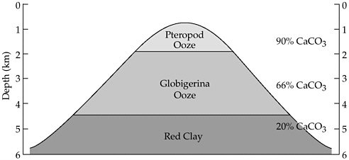
FIGURE 5 Distribution of calcareous sediments
the presence of the red clay was caused by the lack of ooze rather than the addition of red clay from the continents. Buchanan had poured weak acid on a sample of white Globigerina ooze and noted within minutes “that there remained, after the carbonate of lime had been removed, about one per cent of a reddish mud consisting of silica, alumina, and the red oxide of iron.” From this Wyville Thomson was able to conclude “. . . that the red clay is not an additional substance introduced from without . . . but that it is produced by the removal, by some means or other . . . of the carbonate of lime which forms probably about 98 percent of the material of the Globigerina ooze.”
Today we know that the calcite compensation depth is a complex threshold in the ocean whose depth varies under precise conditions that are regulated by the acidity of the seawater. At its simplest, the CCD (as it is customarily abbreviated) is at shallowest in the northern North Atlantic and at its deepest in the northern North Pacific. One of the main regions of deepwater formation today is the Greenland Sea. Close to the area of their formation these waters are well oxygenated, cold, and supersaturated with dis-
solved calcium carbonate. As they start their long journey away from the area of their formation, organic carbon from dying and decaying surface algae is progressively added to these deep waters in the form of mildly acidic carbon dioxide. This makes deep waters more and more acidic the further they are from the area where they were formed and, therefore, progressively more inimical to the deposition of calcium carbonate. The result of this is that the depth of the CCD between the Atlantic and the Pacific is an inclined plane with the deepest part in the northern Atlantic at a depth of about 5.5 kilometers and the shallowest part in the northern Pacific at a depth of only 1 kilometer.
The CCD is one of the most important and fundamental properties of the deep ocean and, as with so many other marine phenomena, we owe our knowledge of it to the voyage of Challenger.
ARRIVAL IN THE NEW WORLD
St Thomas, Virgin Islands, Danish West Indies, March 14-16, 1873, 18° 22′ N, 64° 56′ W
It was squalling heavily from the southeast when Challenger sighted the small island of St. Thomas on March 14, 1873. Rain drove in great sheets across the bow as the ship struggled to drop anchor in the outer harbor. The storm had raged for several days, and the crew was thrown about mercilessly. Only those on watch braved the upper deck. Everybody else stayed in bed. Of those, only the bluejackets and junior officers like Herbert Swire were halfway comfortable in hammocks, which could roll with the tossing of the ship, and Swire pitied those of higher ranks with the dubious privilege of a fixed berth. Then, quite suddenly, the storm vanished and a thick fog formed. Those crewmen who were tardy coming up from below decks found that the first sight of land for four weeks had been suddenly obscured.
The bluejackets and officers knew that the crossing should have
been brisk with the easy trade winds they’d picked up as soon as they left Santa Cruz, but the pestilential Scientifics had insisted on their stops every 200 miles for sounding and dredging. It was enough—more than enough—to irk a seaman’s soul and the sharks that had followed them for the last 1,100 miles of their journey were an unwelcome portent. One, a 20-foot tiger shark made the bluejackets very nervous. To them he seemed too clever by half, swimming up to the lump of salt pork that the Scientifics dangled overboard, sniffing and nudging it disdainfully before swimming away. But let anything fall overboard and John—as Joe Matkin had named the shark—was there “like a lawyer” devouring the morsel in great, slicing bites. There were those aboard who said that John’s untiring presence was a sure sign that somebody would go overboard before they made the West Indies.
And then there was the attitude of the Scientifics. Since leaving Portsmouth they’d kept themselves to themselves, but now that they were getting their specimens on a regular basis they had insulated themselves to the point of standoffishness. All on board felt it to a greater or lesser degree. They would like to know a little more about the reasons for their sacrifice—three and half years away from hearth and home after all! The feeling became so intense that in the first week of March the captain himself prevailed upon the Scientifics’ leader, Professor Wyville Thomson, to discourse on the findings of the expedition so far. The lecture was, all agreed, most interesting and the professor promised to make these talks a regular feature. Joe Matkin even went so far as to transcribe the lecture word for word and send it home to his family in Rutland, but he was known as a grammar-school lad and something of a swot.
That was not the only incident on the voyage. The thief was still up to his old tricks and not many days previously had broken open the officers’ meat locker in the dead of night despite the presence of a heavily armed marine outside the cabin. How he got in was a mystery and the officers were in a rage. And that, too, was a symptom of a continuing source of tension: The officers were eating
as if they were still in harbor while the bluejackets were dining only on salt meat and biscuit. Only the daily allowance of lime juice and grog offered anything palatable. They were, as Matkin put it, “fast coming down to our precise fighting weight.”
Captain Nares elected not to get too close to the township of Charlotte Amalie, the island’s capital, and anchored in the outer harbor known as Gregorie Channel. Having been to St. Thomas before, he well knew its reputation as a virulent source of yellow jack (yellow fever). The Danes, the island’s colonial governors, had already taken steps, in their efficient Scandinavian manner, to eradicate the disease by widening and deepening the channel between the inner and the outer harbor. Now the tidal swell emptied the inner bore of the sewage that collected there daily, washing it out to sea and greatly improving the amenity of the island. But still Nares would not take the risk. Several of the Scientifics had taken out private health insurance and these, without exception, contained exemptions—ports whose level of public health was so poor that the insurance company would not underwrite the risk.
As he stared down from the narrow bridge at the bustle below, Nares reflected that nothing would damage his career faster than losing one of the scientific staff in his charge. And there were, he knew, other ports far worse than this one. Indeed, any of the ports along the “White Man’s Grave”—the bluejackets’ name for the west coast of Africa—were a far worse bet for a sailor’s continued good health than this place. So on the way to Africa he planned to avoid all but Cape Town and Simonstown. But here in Charlotte Amalie he would take no chances either and so, as they waited for the fog to lift, they swung gently at anchor in the outer harbor.
For most of the crew, the view—when it came—was worth waiting for. The little township of Charlotte Amalie on the water-front of the inner harbor was backed by tall thickly wooded hills. For William Spry, confined as he was for so much of his time to his engine room, it was a relief to see “a variety of trees, all green and tempting, as far as the eye could reach” after so many weeks at sea.
Beyond the hills, and dominating the center of the island, was a curious saddle-shaped peak fully 1,500 feet high.
On its flanks, and penetrating in some places almost all the way down to the shore, were vast fields of scrubby undergrowth, the remnants of the sugar-cane plantations that been the island’s staple industry until 1848 when the industry collapsed because of the abolition of slavery. All but one of the island’s plantation owners had been bankrupted by the emancipation, receiving only £50 for each freed slave from the government. Both Swire and Matkin noted that the transition to freedom had not done the island’s economy much good; the Negroes worked only a bare minimum, preferring odd jobs, especially coaling ships, to regular work. St. Thomas had become an important port of call in the West Indies, because it served as the sorting office for the considerable amount of mail that arrived via a variety of shipping lines each month. Yet, both coaling and the mail were vast economic improvements on the island’s more distant past. Two hundred years earlier, St. Thomas was notorious as the focal point for the pirates of the Spanish Main and, more recently during the Napoleonic wars, was a rendezvous for British merchant ships waiting to convoy across the Atlantic on the long and dangerous route to Britain.
Swire loved St. Thomas, despite its checkered history, because the waters around the island were dotted with dozens of smaller islands, some only a few feet across, that the locals called cays. Their outer rims were formed by a profusion of corals that had grown up to the water surface and these, in turn, supported a wide variety of other lime-secreting animals, such as mollusks, that raised the cay above the level of the surrounding sea. This mass of coral and invertebrates was then bound together by the limey secretions of calcareous algae, making a tiny landmass that could withstand the ravages of the local hurricanes and where the footing was easily firm enough for exploration. The lagoon formed in the center of this circle would eventually silt up, giving the cay a firm flat interior that was perfect for sunbathing and picnicking. The waters around
these cays themselves contained an abundance of submerged corals in the form of sheets and branched horns and these, too, lived in communion with tough strands of lime-secreting algae, invertebrate shells, rock-mantling bryozoans, and a confusion of brightly colored fish to gladden the soul of even the gruffest tar aboard.
HMS Challenger had arrived in the kingdom of lime.
THE SYMBIOTIC ECOSYSTEM
The kingdom of lime is the kingdom of the reef, very ancient ecosystems that are found in many places in the tropical oceans of the world. Today, coral reefs occur in the Americas, particularly the Caribbean; in the Red Sea, the Persian Gulf, and around the Maldives in the Indian Ocean; further to the southwest around the Seychelles, Mauritius and off the east coast of Africa; and in east Asia and the tropical Pacific. But these reefs are not all the same; there are significant regional differences in the number and type of species that make up the Pacific reefs and those in the Atlantic and Indian Ocean. Western Pacific colonies tend to be much more diverse than their counterparts, with up to 75 percent more genera and 85 percent more species.
Modern reefs, whether in the Pacific or elsewhere, are among the most diverse ecosystems on our planet. Not for nothing have they been called the “rain-forests of the sea.” And yet, what exactly are reefs? To most of us, familiar as we are with a thousand Jacques Cousteau and David Attenborough TV documentaries, a reef is a familiar feature of the ocean. Mention it and instantly images of fine white coral sands, swaying palm trees, Fletcher Christian, and South Sea Islands are conjured up, images not dissimilar to those about which Herbert Swire wrote. Today, reefs occur mainly in the shallow waters of the tropics, where there is abundant sunlight to fuel the tiny symbiotic algae that live inside the tissues of the coral animal, the polyp, and that provide it with nutrients through photosynthesis. But not all reefs today, or indeed many known from the fossil record, are photosymbiotic.
Non-symbiotic corals have been an important constituent of reefs since at least the beginning of the Phanerozoic eon. During the Archaean and Proterozoic (the time before the evolution of animals with hard parts), there were vast agglomerations of reefs that were composed, not of corals, but of bacteria-like organisms known as blue-green algae.
An important concept common to all reef ecosystems, whether in the present or the past, is the framework builder. Framework builders are the component of the reef ecosystem that produce most of the hard lime or calcium carbonate that gives a reef its structure. In the Proterozoic, the framework builders were the blue-green algae, while in the Phanerozoic (the era since the evolution of animals with hard parts 550 million years ago) they have been any one of a variety of invertebrate species. In fact, one of the things that makes the history of reefs such a complex and confusing subject is the fact that the main framework builder has changed regularly across the course of geological time and superimposed on top of these changes are smaller changes in the composition of the animals and plants (the predators and prey that make the coral world their home) that co-habit with the framework builders.
These variations have led to a lot of confusion over the seemingly simple question as to what, exactly, a reef is. Part of this confusion comes from the way the term is used by geologists (as distinct from biologists). To many geologists, a reef is simply a thickened mass of limestone that is quite distinct from the underlying and overlying rock; and to a further subset of geologists, a reef is synonymous with the concept of oil, for fossil reefs are often associated with hydrocarbons. This notion is especially prevalent in the North American oil exploration community, where the bottom line has always been, well, the bottom line. To an oil geologist, a reef is merely a potential fuel tank, and its biological antecedents are, at best, completely irrelevant. So for many geologists, particularly of the older generation, the term “reef” is more descriptive than anything implying a biological connotation. But that was not the
understanding that prevailed aboard Challenger, because the Scientifics carried with them the recent and hard-won knowledge of the greatest biologist of them all. Charles Darwin, in the days before he wrote Origin of Species, used the observations that he had made on his journey around the world aboard Beagle to develop a theory of how reefs, particularly those that form coral atolls, grow. He showed that reefs in the Pacific grow atop volcanoes that are subsiding below the surface of the ocean. As the volcano sinks, the growing reef first forms a fringe around the island and finally, as the volcano sinks beneath the surface, all that is left is a more or less circular reef. Classic examples of such islands, scattered across the Pacific, are Majuro and Kwajalein in the Marshall Islands. Kwajalein’s ring-shaped lagoon is used as a target for inter-continental ballistic missiles launched from Vandenberg Air Force Base in California.
It was Darwin’s theory that proved the turning point and for biologists since Darwin, the reef concept has been different from that of geologists. To biologists today, a living reef is a colony of tiny animals, polyps, which comprise corals, which in turn live in conjunction with a host of other organisms, together making up the reef ecosystem. Corals and many other reef-dwelling organisms secrete a hard skin of calcium carbonate that makes them the framework builders of the reef.
Coral polyps live symbiotically with algae called zooanthellae. The algae derive nutrients from the animals in the form of nitrogenous waste and carbon dioxide produced by the animals’ respiration, while the coral animals also impart protection and a safe haven in which the algal cells can comfortably make sugars by photosynthesis. In return the corals receive and use the products of photosynthesis; sugar and oxygen.
Other framework builders that contribute to the reef ecosystem include bryozoans and certain types of algae. Together, these build a microcosm in which mollusks, starfish, sharks, eels, and fish thrive in an abundance of color and warmth that collectively make up one
of the most beautiful ecosystems on Earth. It might be the relationship between the zooanthellae and the coral that is responsible for the rather restricted distribution of shallow-water reefs to 30 degrees north and south of the equator and the western sides of the ocean basins. In these regions, the ocean circulatory system keeps the nutrient content of surface waters low so that free-floating algae cannot flourish and the waters remain relatively clear and transparent to sunlight. This creates ideal conditions for the symbiotic relationship between polyps and zooanthellae.
Coral polyps are members of a strange group of animals known as the Cnidaria, pronounced “ni-daria.” The cnidarians have only two layers of tissue; the rest of the animal kingdom (with the exception of the sponges) has three. The two layers of tissue are known formally as the epidermis and the gastrodermis. The names are give-aways: The epidermis is the external skin that protects the animals, the gastrodermis is the internal layer that digests food. Between the two tissue layers of the cnidarians is a layer of jelly, the mesoglea, which provides mechanical support for the rest of the body.
The two-layer (technically known as diploblastic) body plan tells us that the cnidarians, and the corals, are a very ancient group of animals. We can think of them as an experiment in evolution that was later superseded by a better design, the three-layered (or triplo-blastic) body design on which all higher invertebrate animals and all the vertebrates are based. But the diploblastic design cannot be all that bad for the reef-building corals, after a long and illustrious history, are still with us today.
However, it seems likely that photosymbiont-bearing corals evolved only 65 million years ago. Apart from their requirement for clear waters with sufficient sunlight for the symbionts to flourish, photosymbiotic corals, like their deeper-water cousins, must also inhabit water supersaturated with dissolved carbonate to enable the coral polyps to form the protective limey skeleton that is the basis of the reef ecosystem.
The West Indies was not the last place that Challenger encoun-
tered reefs on its long journey. Their next port of call, Bermuda, was famous for them, and within 18 months, off northeastern Australia, Challenger would explore the most spectacular coral reef system in the world.
St Thomas, Virgin Islands, Danish West Indies, March 16 , 1873, 18° 22′ N, 64° 56′ W to Hamilton, Bermuda, Atlantic Ocean, May 9, 1873, 32° 18′ N, 64° 48′ W
After completing their examination of the coral cays of the Danish West Indies Challenger took on coal, food, and water at St. Thomas while the crew contemplated the next leg of their mission, the voyage north to Bermuda and then beyond to the east coast of North America. Just as they were about to set sail, however, intelligence reached them via dispatches that an English vessel was in their area and in need of assistance. On March 23, 1873 Challenger hauled in the anchor and set off in search of the ship. They soon found her, Varuna, out of Liverpool. She had departed New York the previous January but had run into stormy weather and lost her main and mizzenmasts before the crew took to the lifeboats. At some point after that she was boarded by a prize crew who sailed her to within 15 miles of St. Thomas, stripping her of everything that was not nailed down before abandoning her to her fate again. Taking her in tow, Challenger triumphantly sailed her into the little harbor at Charlotte Amalie where she was ceremoniously handed over to the British Consulate.
The next day, March 24, the crew were under orders of science again and set sail on the next leg of their voyage. It was here that disaster struck and the Challenger expedition sustained another fatality. As they were pulling in the dredge, the rope snapped. The tension on the rope, coupled with that of the massive india-rubber accumulator that protected the mast, was so severe that “it carried away an iron block that was screwed in to the Deck,” wrote Joe Matkin, “it struck a sailor boy named William Stokes on the head,
and dashed him to the deck with such a terrible force, that his thigh was broken, and his spine dreadfully injured.” Stokes died of his injuries a few hours later. When the dredge was finally hauled in, it was found to contain a few sad scraps of coral as well as the ubiquitous Globigerina ooze, poor compensation for the loss of so young a life. Two days later, after evening quarters, the crew assembled to say their last goodbyes to the young seaman. The bell tolled softly as the body, wrapped in a lead-weighted hammock as was the custom, slid gently overboard “to be seen no more until that day when the sea shall give up its dead,” as William Spry sadly put it.
The death was a shock to all on board and it was a subdued company that made sail for Bermuda. But the spirits of the bluejackets were raised on April 1 when “Hands to Bathe” was piped and 80 of them went over the side to swim, protected by a gig on shark-watching detail. A fine time was had by all. Other entertainment was provided by the flying fish that chased the ship. Joe Matkin wrote, “On a dark night, if a lighted candle is placed in the ship’s port they will often fly in.”
By March 26, 1873, Challenger was 85 miles north of St. Thomas and sailing north along the easternmost boundary of an area that within a hundred years would strike terror into the hearts of seamen and aviators alike: the Bermuda Triangle.