The Silent Landscape: The Scientific Voyage of HMS Challenger (2003)
Chapter: The Library of Time
The Library of Time
Tristan da Cunha, South Atlantic Ocean, 37°03′S, 12°18′W to Simonstown, South Africa, 34°12′S, 18°26′E
“On the morning of the 15th,” wrote William Spry, “land was in sight, a little speck, at first rising up dark and rugged out of the sea, growing larger and larger as we neared, terminating at length in a huge conical peak some 8000 feet in height, covered in snow.” It was mid-October of 1873 and Challenger had arrived at Tristan da Cunha in the South Atlantic. Some 1,500 miles west of the Cape of Good Hope and more than 2,000 miles from the coast of South America, Tristan da Cunha’s claim to fame is its being one of the most isolated islands in the world. It is the largest in a group of five; the others being Nightingale, Middle, Stoltenhoff, and the aptly named Inaccessible Island. Tristan’s lonely aspect is compounded by its location in some of the roughest waters of the world, the Roaring Forties, and the island is surrounded by sheer 300- to 600-meter-high cliffs. The weather being fine when Challenger arrived, however, they dropped anchor within sight of the only settlement on the island, the tiny hamlet of Edinburgh.
Tristan was discovered in the sixteenth century by the Portuguese navigator Tristão da Cunha but was not colonized until the early years of the nineteenth century when the British set up a colony there to keep a watchful eye on Napoleon, who was incarcerated nearby on St. Helena. To call St. Helena “nearby” is something of a stretch, because it is 1,300 miles to the north. However, the British anxiety to keep “Boney” under lock and key was a
reflection of the paranoia that followed his near victory in Europe in the first years of the nineteenth century. In 1817 the British garrison withdrew from St. Helena, but a corporal named William Glass elected to stay there with his family. Over the years the colony was supplemented by other settlers as well as by shipwrecked mariners, and by the time of Challenger’s visit in 1873 the community comprised about 84 souls distributed among 20 families.
Despite its relatively large size, the island’s only habitable portion is a plateau on the northwest shore, where Edinburgh’s 15 dwellings were built. The little town had named itself in honor of Prince Alfred’s visit six years before. The Challenger crew were warmly greeted by the governor of the island, Peter Green, who confirmed that the island community could furnish the ship with provisions. Alfred Taylor and Joe Matkin oversaw the re-provisioning of fresh meat and vegetables, but the warmth of their welcome was somewhat diluted when they discovered that the inhabitants of the island were not, as William Spry put it, “above trying to make a good bargain out of us.”
During their visit the crew heard a story concerning two Germans who had arrived at the nearby Inaccessible Island some two years before to hunt for seal fur and oil. Contact with Tristan was established early on but nothing was heard from them for some time, and the islanders, it seemed, were concerned about them. This concern seemed to be typical of the Tristaners and several of the officers noted with approval the islanders’ humanity. Wyville Thomson even went so far as to write, “The character of the inhabitants stands deservedly high; they had invariably assisted, to the best of their ability, all shipwrecked persons. . . .”
On October 16, 1873, Challenger set sail to the west in search of Inaccessible Island, the crew dredging and sounding as usual and finding that the sea between the two islands was shallow. On Inaccessible they found themselves besieged by penguins that attacked tar, officer, and Scientific alike with sharp-beaked enthusiasm. “The yelling of the birds is overpowering,” wrote
Moseley, “I can call it nothing else.” To their amazement they also found the two Germans, in good health but without transport. Moseley wrote, “In the early morning, we made out with the glass two men standing on the shore gazing at the ship. . . . They were overjoyed at the chance of escape from the island; we gave them breakfast, and heard their story.”
The two brothers Gustav and Frederick Stoltenhoff came to the island in 1871 to hunt seal and penguin but early on lost their boat. This was not of too much concern to them because they had sporadic contact with the initially friendly Tristaners. However, as the months wore on, that friendship degenerated into suspicion and jealousy and eventually the Tristaners sabotaged the Germans’ livelihood on the island. By now, the autumn of 1873, the brothers had had enough and wanted passage off the island away from their tormenters.
After hearing how badly the Tristaners had treated the brothers, Nares knew that he had only one choice. He would take the Germans with him to the Cape of Good Hope and make sure they were safely ensconced there before they moved on for the deep south and the Great Ice Barrier. He was not the only one on board to revise his opinion of the good character of the Tristan islanders on hearing this tale, but with no plans to return to Tristan there was nothing more to be said or done.
After a brief visit to the nearby Nightingale Island on October 18, 1873, Challenger set sail for Simonstown at the Cape of Good Hope, arriving there on October 28th. There she would stay for six weeks’ re-provisioning and refitting for the hardest leg of her long voyage, south to the Great Ice Barrier. The knowledge of the impending journey loomed like a specter at the back of everybody’s minds. In part their trepidation came from knowing that only four other expeditions had been to the vast silent fastness of ice at the bottom of the planet since Captain James Cook, one of the most famous navigators of all time, discovered the Antarctic continent
exactly 100 years earlier. Challenger’s voyage would also be groundbreaking, because no steam-powered ship had yet attempted to reach Antarctica. It was this knowledge that hung heavy in the minds of the crew that autumn of 1873. But as if to reassure them, when Challenger arrived at Simon’s Bay they discovered that she was not the only ship with a fine scientific pedigree there. HMS Rattlesnake rode at anchor nearby, carrying recent mail and newspapers from England. Rattlesnake had carried Thomas Henry Huxley, one of the Challenger expedition’s most stalwart supporters, to the South Seas and Australia between 1846 and 1850. Huxley’s findings on that voyage formed the basis of his monumental tome, the Oceanic Hydrozoa, which, at least in part, explained his support of the Challenger expedition.
Rattlesnake had just returned from a skirmish of the Ashanti Wars (or, as Joe Matkin called them, the Ashantee Wars) and her commander, Commodore Commerell, lay badly hurt on shore, seriously wounded by bullets in the lungs and legs. Challenger’s men had already come across one ship, Simoom, bound for this second skirmish between the British Empire and the local Ashanti tribe. It had all been sparked by the local chief’s (or asantehene’s ) desire to preserve his empire’s last trade outlet to the sea, at the old coastal fort of Elmina, which the British had annexed in 1872. In early 1873, the asantehene sent an army of 30,000 warriors to retake Elmina. They were unsuccessful, but managed to gain an important foothold in the area. The British government appointed Garnet Wolseley, a major general in the British Army, as administrator and commander in chief of the region and gave him orders to drive the Ashanti out.
This was the situation when Challenger arrived at Simon’s Bay in October 1873. The war rumbled on throughout Challenger’s stay in South Africa until the British eventually won the battle of Amoafo in the late spring of 1874. The Treaty of Fomena then forced the Ashanti to pay an indemnity of 50,000 ounces of gold,
renounce their claim to Elmina, end alliances with other warring tribes, withdraw their troops from the coast, keep the trade routes open, and halt the practice of human sacrifice.
To occupy themselves before their Antarctic ordeal, and despite the Ashanti Wars, the officers and Scientifics awarded themselves a holiday. Throughout that Cape summer, as the prevailing south-easterlies blew long and warm from the Indian Ocean, they enjoyed a sybaritic life. William Spry took in the sights. To his eyes, the buildings of Cape Town, some 24 miles from their anchorage off Simonstown, were unimposing and the digs at the local Masonic hotel uninspiring: “the headquarters of Jews, diamond merchants and successful diggers.” Indeed all around them was evidence of the new South African diamond rush and more than one of the bluejackets, including the expedition’s photographer, deserted, tempted by the lure of an easy fortune. After all, the choice was that or another two years aboard the crowded corvette, and most immediately, a long trawl through the worst waters on the planet: the Roaring Forties.
In the 1860s, near the old Dutch colonial town of Zoutkloof, children playing on the banks of the Orange river accidentally discovered the diamond fields. The town was located in a region known as Saltpans Drift, which could be reached only by crossing the forbidding Karroo Desert. The children found a large stone that weighed in at a spectacular 213/16 carats. It caught the attention of a trader who sent it to Dr. Atherstone, a local geologist, who pronounced it a diamond of the highest quality.
A systematic search soon started and almost immediately turned up a stone of such prodigious dimensions, 831/2 carats, that it was named the “Star of South Africa.” William Spry wrote, “The area over which diamonds have already been found is very extensive, and how much farther it may extend cannot even be conjectured. Sufficient diamondiferous country is already known to provide many years employment for a large population. Diamond-digging is certain to become a permanent industry. . . .” How prophetic!
Today of course, the South African diamond industry is one of the largest in the world
Back at Simonstown the bluejackets’ life was quiet and industrious. Joe Matkin, for example, was preoccupied with the task of refitting and re-provisioning the ship for the Antarctic voyage. By the beginning of December Challenger was newly rigged, freshly caulked and painted, and fitted with a new deck house for the comfort of the Scientifics. She groaned under the weight of six months’ worth of provisions and the stoves now installed in every corner of the ship. Joe Matkin was particularly relieved that one of the stoves was close to his hammock; he, for one, would not suffer through the long Antarctic nights.
Shortly before she left South Africa Challenger paid a visit to Cape Town. Two sumptuous balls, on successive nights, were given in the Commercial Buildings there: the first by the Challenger men, the second by local dignitaries. “Everything was done by them to ensure success,” wrote William Spry, “and, without any flattery, nothing could have exceeded the completeness of the arrangements or the hospitality of the givers.” The next day they “swung” the ship in Table Bay harbor to calibrate the compasses before they returned to Simons Bay to complete refitting and loading. At 6:30 in the morning of December 17, 1873 Challenger put out to sea.
By the 19th the ship, by now 80 miles south of the Cape, entered the Agulhas Current, a body of warm water that originates in the Indian Ocean and flows initially westward before being forced back in a southeasterly direction after meeting the cold Atlantic easterly drift current. In many ways it is the South Atlantic version of the Gulf Stream and the Scientifics were keen to take its measure. They found that the warm waters of the Agulhas Current extended to a depth of 400 fathoms (more than 2,000 feet) and that the current itself was more than 250 miles wide. Soon after Challenger turned her blunt prow south, toward the Marion and Prince Edward Islands, the most westerly of the chain of islands that includes the Crozets and Kerguelen. A few days later and they were
among the Roaring Forties where the seas raced unfettered around the planet, and it was here, in this blighted place, that Wyville Thomson finally threw in the towel and capitulated in a long-running argument with his right-hand man about the true nature of the sediments of the ocean floor.
THE LIBRARY OF TIME
The officers, bluejackets, and at least some of the Scientifics had very quickly become bored with the white mud that endlessly filled the dredges, day after day. In his account of the voyage, William Spry refers often to the retrieval of monotonous gray oozes from the seabed. Lord George Campbell, as we have seen, was more forthright in his disgust, and even Henry Moseley, that gifted naturalist, chose to close his own account of the voyage with the words, “as the same tedious animals kept appearing from the depths in all parts of the world, the ardor of the scientific staff even abated somewhat. . . .” In fact, in his excellent account of the voyage, Notes by a Naturalist, discussion of deep-sea dredging occupies precisely 2 out of 540 pages! The tedium of dredging and sounding very likely accounted for the high attrition of ship’s personnel by desertion.
But two men aboard were not bored by the dredging. Charles Wyville Thomson and John Murray knew very well that achieving an understanding of the nature of the ocean-floor sediments was a critical goal of the expedition. By the time they reached the Caribbean, the chemist Buchanan had already shown that the white Globigerina and Pteropod sediments could be dissolved away to leave the red clay that they had found in the deepest parts of the abyss, but the central, unanswered question was where that white sediment had come from in the first place. Wyville Thomson firmly believed that the oozes were native to the ocean floor. John Murray was equally certain that the oozes were formed at and near the ocean surface and that the white carpets of ooze on the seabed
were merely the detritus left behind after shell-secreting animals died and their shells fell through the abyss.
By the time Challenger started her transit to the Great Southern Ice Barrier, Murray had gathered abundant evidence that the components of the oozes lived at or near the surface. Indeed, even the scientifically illiterate Lord George Campbell had noticed that, and as they approached St. Paul’s Rocks, he wrote “We have found all the globigerinae and foraminiferae, which science (young as yet in these matters) said lived at, and only at, the bottom, alive at small depths below the surface and sometimes on the surface.” There could be no doubt that this conclusion was the correct one and Wyville Thomson had to acknowledge that he was wrong and his junior colleague was right.
It was a bitter pill to swallow, because he, together with William Carpenter, his estranged scientific partner back home, had nailed their scientific colors to the mast on this issue. But Wyville Thomson was magnanimous in defeat. By the time they entered the Southern Ocean he had completed a paper for the Philosophical Proceedings of the Royal Society on the subject. In it he wrote,
Since the time of our departure Mr. Murray has been paying the closest attention to the question of the origin of this calcareous formation which is of so great interest and importance on account of its anomalous character and its enormous extension. Very early in the voyage he formed the opinion that all the organisms entering into its composition at the bottom are dead and that all of them live abundantly at the surface and at intermediate depths over the Globigerina ooze area. The ooze being formed by the subsiding of these shells to the bottom after death . . . I have formed and expressed a very strong opinion on the matter. It seemed to me that the evidence was conclusive that the foraminifera which formed the globigerina ooze lived on the bottom and that the occurrence of individuals on the surface was accidental and exceptional; but after going into the thing carefully and considering the mass of evidence which has been accumulated by Mr. Murray I now admit that I was in error and I agree with him that it may be taken as proved that all the materials of such deposits with the exception of course of the remains of animals which we now know to live at the bottom at all depths, and which occur in the deposit as foreign bodies, are derived from the surface.
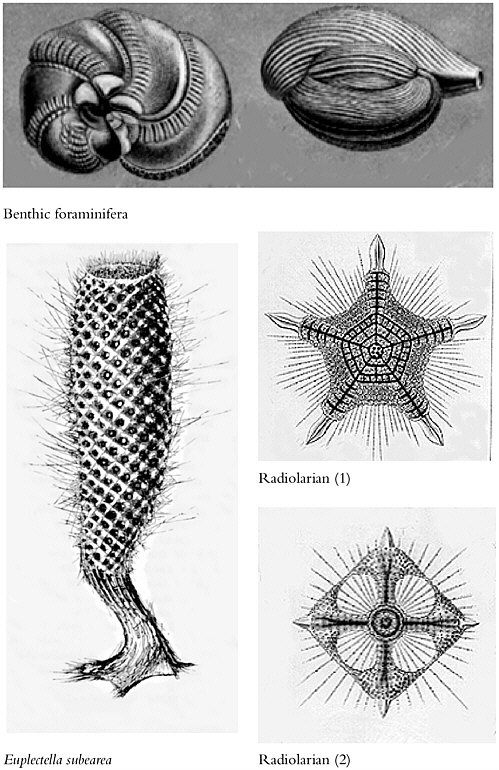
As Challenger traveled around the world, the expedition’s artist, J. J. Wild, had plenty time to draw pictures of the foraminifera that are the main component of Globigerina ooze. Many of the expedition report’s volumes contain his exquisite drawings of these strange and wonderful creatures. Indeed, one volume, written by the charismatic and ebullient John Murray, is devoted exclusively to the first detailed classification of these sediments. Yet, during and even after Challenger’s voyage, as Murray was compiling his monumental work, no one could have believed that these tiny creatures would, within a century, become vitally important for deciphering the details of our planet’s climatic and oceanographic history. For the geologist and oceanographer there is simply nothing to match the detailed information trapped in the sediment of the deep sea; it is the library of time. Figure 7 shows some of the deep-sea fauna Challenger dredged up from the deep.
Today we recognize three types of deep-sea sediments: terrigenous sediments that originate on land, authigenic sediments that were formed in place on the seafloor, and biogenic sediments composed of the skeletal debris of tiny plankton. There are basically two types of biogenic sediment: that formed by the accumulation of siliceous radiolaria and that formed by the accumulation of calcareous foraminifera. The importance of both stems from the fact that radiolaria and planktonic foraminifera live at or near the ocean surface and their shells incorporate a record of surface-water conditions as they grow. But it is the calcareous sediments, formed by the rain of dead planktonic foraminifera through the abyss, that have traditionally formed the backbone of climatic and oceanographic research.
The vast blankets of calcareous sediment formed by these tiny creatures are neither homogenous in composition nor of constant thickness. Calcareous oozes are common in the low and mid-latitudes while in other places, particularly the high latitudes, radiolarian oozes tend to dominate.
The thickness of the calcareous ooze blanket is directly propor-
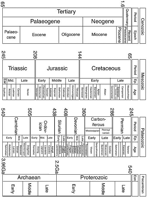
tional to its age. This is simply because new ocean floor, as we have seen, continuously forms at the mid-ocean ridges and then spreads away on either side, aging and collecting a progressively thicker sediment blanket as it does so. It follows, therefore, that the thickest, and oldest, sediments should occur at the edges of the ocean basins and this is indeed what we find. In fact, the oldest sediment occurs at the far western edge of the biggest ocean basin of them all, the Pacific. In this region the deepest sediment is 200 million years old—an age that places it firmly in the middle of the Jurassic period of Earth history. Figure 8 shows the geological timescale.
This overall process varies locally, particularly in areas with a high degree of upwelling that brings nutrients from deep waters and fuels faster than normal surface-water productivity. In such areas, the plankton rain from the surface tends to be enhanced. The most prominent upwelling regions are at the equator, off the west coasts of the continents and off Antarctica. Zones of minimum upwelling and, therefore, productivity, occur in the central regions of the oceans known as the gyres, a good example of which is, as we have seen, the Sargasso Sea. In fact, the accumulation of siliceous sediment is a better indicator than carbonate sediment of high productivity, because in surface waters siliceous organisms tend to dissolve more readily than carbonaceous ones. This means that if siliceous oozes actually manage to accumulate on the seafloor, productivity must have been seriously high. Conversely, in regions below the calcite compensation depth—where the red clays that so fascinated Challenger’s Scientifics begin to form—the local calcareous sediment blanket can be thinner because the acidity of the seawater begins to dissolve the foraminifera as they reach the bottom. It was the study of these calcareous sediments that revolutionized the earth sciences in the twentieth century, because it turns out that the forams that make up such a large percentage of the sediment are exquisitely sensitive to climatic change.
The success of the Challenger expedition spawned many other cruises, one of the most interesting being the German Meteor expe-
dition of 1925-1927, led by the noted German chemist, Fritz Haber. Haber’s claim to notoriety was the development of the mustard gas the German army used in the trenches of the First World War. After the war Haber, aboard the Meteor, experimented with extracting gold from seawater. The German government hoped to pay the reparations required by the Treaty of Versailles with that gold. In this the expedition was a failure; there is gold in seawater but the technology of the early twentieth century was not equal to the task of extracting it. However, in other ways the expedition was a notable success. One of the biologists on board, Wolfgang Schott, studied the sediments that Meteor dredged up in the South Atlantic.
The technology of piston coring was then in its infancy. The apparatus that Schott used was of the simplest kind, simply a tube with a glass liner and a lead weight to drive it into the sediment. The cores that it retrieved were, therefore, very short, typically less than a meter, but the very simplicity of the apparatus allowed the ordering of the sediments within them to remain almost completely undisturbed. This clever technique enabled Schott to observe that the sediments in all the cores he retrieved were divided sharply into two layers differentiated by the composition of the animals, specifically the planktonic foraminifera, comprising each layer.
The upper layer, about 25 centimeters thick, contained shells of a species of planktonic foraminiferan (known formally as Globorotalia menardii) that flourishes in this region today, while in the lower layer this species, and others that were commonly associated with it, were completely absent. Schott made the huge intuitive leap that the lower layer had been formed during the last ice age and the menardii and the other species (which together comprise the so-called menardii assemblage) were absent because they could not tolerate the lower water temperatures associated with glaciation and so had retreated to lower, warmer, latitudes. It was the first hint that the species composition of deep-sea sediments could be used to infer climate, and it spawned an entire industry devoted to unraveling the mechanisms of climate change.
After the end of the Second World War an ex-paratrooper named Goesta Wollin teamed up with an oceanographer named David Ericson at the Woods Hole Oceanographic Institution (WHOI). Together they took Schott’s findings further and revolutionized the study of the ice ages, putting it on a properly scientific footing for the first time. More cores were taken with more advanced coring technology, but everyone agreed that Schott’s original finding was correct: The change in the foram assemblage down-core recorded the occurrence of an ice age some time within the relatively recent past. The corollary was obvious: Drill deeper and the changing species richness of the planktonic foraminifera in the sediments might provide a continuous record of climatic history. But first this most recent ice age had to be understood in detail.
In 1948, the steel-hulled ketch Atlantis of WHOI anchored over the western terraces of the mid-Atlantic Ridge, giving a new coring device—developed by the father of modern oceanography Maurice “Doc” Ewing—its first trials. One of the big advantages of Ewing’s device was that it was simply and ruggedly constructed of stainless-steel tube whose thousand-pound lead weight was extremely effective at driving the corer deeper into soft sediment. The coring tube itself was more than 12 meters long—much longer than that of the expensive and delicate Kullenberg corer used by Schott. On their first attempt they retrieved a core more than 9 meters long, effectively trebling the core-recovery record.
Over the next few years Ericson and Wollin collected cores from all over the Atlantic Ocean as well as from the Caribbean, and corroborated Schott’s finding that certain species indicated warm-water (interglacial) conditions while others signified cool-water (glacial) conditions. The warm-water assemblage, as Schott had first observed, was dominated by the foram species Globorotalia menardii. The cool-water assemblage was dominated by another species, which rejoiced in the glorious name Neogloboquadrina pachyderma.
It appeared that Ericson and Wollin had developed a universal and fantastically simple technique for determining the temperature of the oceans in the past.
On one memorable day in January 1951, they raised a long core from a depth of more than 4 kilometers in the Caribbean region and found that it contained more warm and cold stages than they had ever before discovered. Their excitement was intense. Clearly, this area was uniquely sensitive to glacial-interglacial fluctuations in temperature and, importantly, accumulated sediment slowly enough to incorporate more of these variations than usual. By the mid-1950s Ericson and Wollin had compiled data showing that the sequence of the four most recent glacial and interglacial stages was reflected in foram abundances collected all over the Atlantic and Caribbean regions. These results made them confident that their method was the best way of measuring temperatures in the deep ocean.
At this point Ericson and Wollin ran into a conflict with the king of the new science of isotopic temperature analysis, Cesare Emiliani. Emiliani had developed a technique first suggested by the Nobel laureate chemist, Harold Urey. Urey’s idea was that the proportion of the two common forms (or isotopes) of oxygen in a fossil shell would vary according to the temperature of the water in which it grew. The warmer the water, the higher the proportion of the light isotope of oxygen, oxygen-16; the cooler the water, the higher the proportion of the heavy isotope, oxygen-18. A simple ratio could be converted into an accurate temperature. Urey’s idea turned out to be correct and by the mid-1950s the development of oxygen-isotope palaeothermometry was under way in several labs around the world. Because Emiliani specialized in applying the technique to forams, it was inevitable that sooner or late he would run across the work of Ericson and Wollin.
Oxygen-isotope temperature measurements of foraminifera agreed well with the faunal-abundance method of temperature
determination near the tops of cores but as one went deeper, significant discrepancies began to appear. By the age of 100,000 years, the agreement between the two techniques was severely compromised. Ericson and Wollin were convinced that their data agreed well with the four continental glaciations known from land-based studies, while Emiliani was equally convinced that his data showed that there were many more than merely four glaciations.
As the analyses continued, the discrepancy got wider and wider and soon Emiliani was claiming that there had been as many as 20 glaciations—or 40 glacial-interglacial cycles during the Pleistocene, broadly the last 2.6 million years. The debate heated up when, in their 1964 book, The Deep and the Past, Ericson and Wollin pointed out the difficulties of distinguishing the contributions of temperature and ice-sheet growth and decay to any given oxygen-isotope measurement. The contaminating influence of ice-sheet growth and decay occurs because in times of glaciation the light isotope of oxygen, oxygen-16, is locked up in the ice sheets, leaving the oceans artificially depleted in it. Ericson and Wollin believed that the isotope chemists relied too much on their high technology. They even went so far as to suggest that the high cost of the mass spectrometers needed for isotope measurements led scientists to suspend proper skepticism and believe the numbers too readily.
By 1967 Louis Lidz, a student of Emiliani’s, had shown that with some minor statistical massaging Ericson and Wollin’s data could fit comfortably after all with the isotopic data. The debate and the bad feeling had been so much hot air, generated by two equally valid techniques that were still in their infancy and whose complexities had not been properly understood. Both the isotope and the foram-abundance techniques for measuring temperature were developed over the next few years.
The problem of how to separate the temperature from the ice-volume effect was addressed by an isotope geochemist at the University of Cambridge in England named Nick Shackleton. Shackleton reasoned that deepwater temperatures would remain
stable—at around 4°C—over a glacial-interglacial cycle and that this stability could be measured using bottom-dwelling (benthic) foraminifera. If this deep-water temperature signal was then subtracted from the surface-water temperature signal (from surface-dwelling forams), the difference would be a true temperature signal.
As time went by, however, it became clear that the calculation was not so simple after all. With the advent of the Deep Sea Drilling Project, more and more benthic isotope data from around the world suggested that the temperature of the deep ocean was not as stable as Shackleton supposed. Ironically, help was to come from a development of the foram-abundance temperature technique.
John Imbrie was a gifted mathematical paleontologist who, with his graduate student, Nilva Kipp, had developed a multi-dimensional statistical technique, known as factor analysis, into a way of measuring temperatures over recent glacial-interglacial cycles using subtle changes in the abundance of several species of planktonic foraminifera considered, in mathematical terms, simultaneously. When the Imbrie and Kipp technique could successfully reproduce modern-day temperatures from core-top data (that is, recently deposited sediments), they were ready to extend the technique into the past. However, there was one major and apparently insurmountable obstacle: With increasing age, the modern-day species of planktonic foraminifera that the technique was based on become progressively rarer. For practical purposes anything more than about 30,000 years old was beyond the range of their technique. However, in younger strata, the factor-analysis technique proved itself to be in very good agreement with the oxygen-isotope method and gave Shackleton the opportunity to re-estimate the partitioning of oxygen isotopes between temperature and ice volume. Thus began a long-running collaboration between Imbrie and Shackleton, which also spawned one of the most ambitious projects in modern geology: the CLIMAP (Climate: Long-range Investigation, Mapping, and Prediction) project.
The CLIMAP project’s goal was to calculate the temperature
of the entire Earth during an average August during the height of the last ice age, 18,000 years ago, using the Imbrie and Kipp and oxygen-isotope techniques. At that time no one was quite sure what caused ice ages, although the suspicion was growing that the theory put forward by the Yugoslav astronomer, Milutin Milankovitch, was correct. Milankovitch suggested that ice ages were caused by cyclic variations in several parameters of the Earth’s orbit around the sun: tilt, obliquity, and eccentricity.
The CLIMAP results were spectacular, and in 1976 the team published their results, in the form of a temperature map, in the prestigious journal Science. The team did not limit themselves to foraminifera but used other planktonic groups such as the coccoliths and radiolaria. All seemed well, until they started to examine their data from the tropics.
The CLIMAP project showed that the temperature of the tropics had been only about 2°C lower during the height of the last glaciation. This was surprising because the rest of the world had had an average global temperature about 5°C lower than that of the present day. But the transfer functions based on the several different groups examined, plus the oxygen-isotope data, all showed that the glacial tropics had been warmer than expected. However, the CLIMAP data did not agree with data derived from land. In particular, evidence from the fossil distribution of mountain vegetation clearly showed that the tropics had been 5°C colder with a snow-line altitude at least a kilometer lower than today. This discrepancy between the CLIMAP data and the data from the land had profound implications for the new science of climate modeling.
As climate models were developed in the 1970s and 1980s, it became clear that they were very sensitive to the initial parameters that controlled the behavior of the model as the program was run. These parameters are technically known as “boundary conditions.” When climate modelers attempt to model future climates, they first calibrate their models by testing them against the past using boundary conditions derived from data from the geological record. When
the CLIMAP data set was used to define the critical boundary conditions for the temperature of the tropical ocean at the last glacial maximum, it was found that the models could not successfully predict the temperature of the land estimated from the vegetation and snow-line evidence. The CLIMAP scientists insisted that the problem lay with the accuracy of the models but there was a growing suspicion that there was something wrong with the temperature estimates derived from the CLIMAP data set. In the 25 years since the CLIMAP paper, more and more evidence has been gathered that seems to contradict the project’s findings. Data from South America confirm that conditions there were at least 5°C cooler than today, while other results show that the sea surface temperatures near Barbados were also about 5°C colder than today.
Even today the jury is still out on the question of whether the CLIMAP project members got it right. There has been some justified criticism of the transfer-function approach, most notably because it is the rarer species that are the most climatically sensitive. Because the CLIMAP team counted only 300 specimens or so and then multiplied this figure to estimate population abundances, they might have severely underestimated the abundance of important species. However, there is still the fact that oxygen isotopes do agree well with the transfer-function approach. The struggle to reconcile the two approaches and accurately measure ancient sea-surface temperatures continues.
But Charles Wyville Thomson and John Murray were blissfully unaware that their beloved deep ocean sediments would become so important, and cause so many headaches, in the future. It was enough for them to know at last where these sediments came from—the surface of the ocean.
But now all aboard had other preoccupations because they knew that the next leg of their epic journey would be by far the hardest. Ahead of them lay the bleak and little-known islands of Crozet and Kerguelen, inhabited only by penguins and whalers, the whalers often fugitives from justice, and beyond that, the edge of the Victorian scientific world, the Great Ice Barrier of the Antarctic.