The Next Decade of Discovery in Solar and Space Physics: Exploring and Safeguarding Humanity's Home in Space (2025)
Chapter: Appendix D: Report of the Panel on the Physics of Ionospheres, Thermospheres, and Mesospheres
D
Report of the Panel on the Physics of Ionospheres, Thermospheres, and Mesospheres
D.1 INTRODUCTION
The decadal charter for the Panel on the Physics of Ionospheres, Thermospheres, and Mesospheres (ITM panel) is to identify the highest-priority science goals (PSGs) for the coming decade and develop a compelling research strategy to address those goals that incorporates both ground- and space-based investments, model development, interdisciplinary emerging opportunities, and enabling capabilities needed to lay the groundwork for continued advancement in future decades. Per the ITM panel statement of task, this report assumes that the Geospace Dynamics Constellation (GDC) and Dynamical Neutral Atmosphere–Ionosphere Coupling (DYNAMIC) missions will be executed as a prerequisite to the strategic implementations described in this report.
The vision presented in this panel report reflects an overall paradigm shift relative to past reports, which is motivated by a growing recognition that the ionosphere–thermosphere–mesosphere (ITM) is more than just the bridge between the lower atmosphere and magnetosphere. Instead, the ITM represents within geospace the clearest example of physical complexities that require a system science approach to their investigation.
The ITM hosts a myriad of processes encompassing chemical reactions, fluid dynamics, plasma physics, and their coupling, as the atmosphere transitions from a predominantly well-mixed neutral gas to a magnetized plasma. Beginning nearly 100 years ago with the discovery of the Appleton Anomaly and extending to the dramatic ITM response to the 2022 Hunga Tonga–Hunga Ha‘apai volcanic eruption, the community has mostly focused on individual phenomena or state parameter observations to elucidate the underlying ITM processes. Furthermore, the limitations in the technological capabilities, budget resources, and interagency coordination of the past 2 decades drove previous decadal surveys to construct phenomenologically focused goals within individual regions. Although this approach served the community well for that time, the next great step for ITM science is to delve into the intricacies of the processes acting on and within the ITM when viewed as a system. This endeavor requires a transformative system science approach that is reflected in the next decade’s science goals and implementation strategies, which are detailed in the sections that follow.
Science theme: Embrace a system perspective as an enabling paradigm for understanding complexity in the ITM and in the geospace system in which the ITM is embedded.
As illustrated in Figure D-1, further advances in ITM science require that the research be conducted within a system science paradigm that emphasizes the complex linkages between different regions, scales, domains, and processes; quantifies the relative significance of competing causal pathways; and establishes the baselines from which emergent behavior can be distinguished.

SOURCE: CEDAR (2011), https://cedarscience.org/sites/default/files/2021-10/CEDAR_Plan_June_2011_online.pdf.
National awareness of the importance of the ITM region to U.S. infrastructure has grown in recent years, as demonstrated by the establishment of the 2019 National Space Weather Strategy and Action Plan (SWSAP) (NSTC 2019) and the 2020 Promoting Research and Observations of Space Weather to Improve the Forecasting of Tomorrow Act (PROSWIFT 2020). The ITM manifests many different space weather phenomena that are known to adversely affect numerous technological systems and applications in the public and governmental sectors. It is imperative that the ITM community make significant progress in the fundamental understanding of the ITM as an interconnected system if we are to meet society’s space weather forecasting needs and fulfill obligations defined by the PROSWIFT Act.
A transformation in the approach to implementation is required to support ITM’s system science focused goals. The traditional paradigm of isolated and often temporary observational platforms and experiments within the discrete ionosphere, thermosphere, and mesosphere regions is no longer adequate. Beginning with the key system science–centric GDC and DYNAMIC missions, the next decade’s implementation strategy emphasizes multipoint, multistate observations and well-coordinated heterogeneous observations that together address the National Aeronautics and Space Administration (NASA), the National Science Foundation (NSF), and the National Oceanic and Atmospheric Administration (NOAA) priorities and needs.
Overall implementation strategy: Conduct research within a system science paradigm that emphasizes the complex linkages between different regions, scales, domains, and processes of the ITM; quantifies the relative roles of competing causal pathways; and establishes the baselines from which emergent behavior can be distinguished.
The implementation strategy presented in this panel report requires investment in new approaches to conducting ITM research, such as harnessing opportunities to access space, establishing distributed and heterogeneous ground-based instrument networks, and utilizing next-generation data science tools and modeling.
Programmatic implementation strategy: Establish an overarching interagency framework to coordinate the use of diverse assets for ITM research throughout all programmatic levels.
A key part of achieving these system science goals in the next decade can only be realized through the observations provided by the GDC and DYNAMIC missions, flying jointly. By simultaneously observing key ion, neutral, chemical, and electrodynamic parameters in multiple local time and longitude sectors, GDC and DYNAMIC will provide the crucial foundation upon which to grow ITM system science, especially when tightly coordinated with ground-based sensors, which provide key altitude-resolved information within rapid and highly variable ion-neutral interaction pathways, and models, which provide insight into the underlying physical processes that govern the observed responses.
Foundational implementation strategy: Within the next decade, implement the primary GDC and DYNAMIC missions contemporaneously and ensure the availability of strategic ground-based observational assets and modeling.
In summary, the ITM is a unique natural laboratory that is invaluable for advancing interdisciplinary science. The priority science goals and objectives defined in Sections D.3 and D.4, along with the implementation strategies defined in Sections D.5 and D.6, reflect the tremendous benefit of transforming the ITM community’s focus toward system science investigations that advance both fundamental and applied knowledge. The ITM community is well positioned to make incredible scientific progress over the next decade through the implementation of the strategies described in this report. These efforts are well suited to promote engagement and training of the next generation of scientists and engineers, thus ensuring a vibrant future for ITM system science.
D.2 CURRENT STATE OF IONOSPHERE–THERMOSPHERE–MESOSPHERE SCIENCE
Over the past decade, the ITM community made significant advances in the understanding of the ITM system through projects and vigorous programs promoted at the community, national, and international levels. Diverse programs within agencies, as well as initial multiagency efforts, resulted in scientific discoveries of new phenomena and expanded understanding of the interconnection and importance of the underlying physics to the overall geospace system. These important findings have only reinforced the growing need for a holistic, system-focused approach to ITM research that emphasizes understanding the vast transition in governing physics over this altitude range in near-Earth space, which is critical to modern technological society.
A common hallmark of recent discoveries, emphasizing the need for system approaches, is rooted in the community’s growing understanding of the large number of simultaneous pathways and processes spanning the ITM, both within and external to it. Most components of the upper atmosphere interact in two-way feedback loops, including lower atmosphere forcing of the upper atmosphere, dynamic ion-neutral coupling, and variable solar and magnetospheric influences.
Studies of the ITM system forcing during natural events revealed the importance of coupled dynamic processes. The August 2017 total solar eclipse, traveling over the heavily instrumented continental United States, revealed a rich spectrum of propagating ionospheric disturbances during the supersonic eclipse shadow passage.
This unique event drove advances in whole atmosphere modeling capabilities and quantitative understanding of nonuniform solar extreme ultraviolet (EUV) flux influences on ITM ionization. The resulting whole atmosphere model improvements were also part of general Coupling, Energetics, and Dynamics of Atmospheric Regions (CEDAR) community progress in multiscale and data-driven modeling along with data assimilation. Such efforts are broadly important and provide insights into long-standing problems such as a quantitative understanding of sunset and sunrise ionospheric dynamics, ionospheric variability (important for space weather and its operational effects), ion-neutral coupling, and preconditioning influences.
The 2022 Hunga Tonga–Hunga Ha‘apai underwater volcanic eruption provided a rare example of extreme natural forcing that spurred community efforts into understanding whole ITM system responses to forcing. The eruption injected huge amounts of water vapor into stratospheric circulation and launched a myriad of atmospheric waves that were unexpectedly observed to propagate around the world several times. The ITM response also included large-scale ionospheric electron density depletions extending well beyond equatorial latitudes. This unprecedented forcing event has accelerated efforts to use the ITM system-wide Tonga response to better understand whole atmosphere coupling through studies that emphasize the importance of gravity wave forcing from the lower atmosphere, filtering effects of wave breaking and regeneration in the mesosphere and lower thermosphere, subsequent driving of pronounced ionospheric features, and the role of background thermospheric winds in mediating transient behavior.
Significant progress in the past decade has been made on the long-standing topic of the ITM’s complicated response to magnetic storms. The severe effects of the St. Patrick’s Day 2013 and 2015 storms, along with combined coronal mass ejection (CME) and intense X-class solar flare impacts in the strong September 2017 event, have shown that both ionized and neutral ITM components have dynamic responses (e.g., neutral wind surges driven by intense cross-field ion flows) with different relative influences and recovery times. During storms, deep ionospheric electron density depletions, known as “super-bubbles,” have been observed during storms to extend across a wide range of background magnetic field angles, from equatorial latitudes to the plasmasphere boundary layer, challenging traditional regional-based concepts of ITM electrodynamic coupling and demanding a holistic approach to their analysis.
In recent years, researchers analyzing historical data from the Two Wide-angle Imaging Neutral-atom Spectrometers (TWINS) and Thermosphere, Ionosphere, Mesosphere Energetics and Dynamics (TIMED) satellite missions discovered that the neutral exosphere also exhibits large density perturbations in response to geomagnetic storms. Because these disturbances span thousands of kilometers across Earth’s near-space environment and involve thermal and nonthermal coupling of the exosphere with ambient ions and neutrals, a complete understanding of their origin and impact on the geospace system requires a systems science framework. NASA’s Carruthers Geocorona Observatory, a NASA Heliophysics science mission of opportunity scheduled for launch in 2025, will provide the first dedicated observations of global exospheric structure and dynamics needed to assess the role of exospheric charge exchange in mediating both atmospheric escape as well as the geospace response to geomagnetic storms, through the dissipation of magnetospheric ring current energy and the ionospheric replenishment of storm-driven plasmaspheric depletions.
Ion-neutral charge exchange is a fundamental ITM process during quiet geomagnetic conditions as well, particularly between singly ionized oxygen (O+) and neutral atomic oxygen and hydrogen (O and H), the dominant constituents in Earth’s upper atmosphere. Because O-O+ charge exchange transfers momentum and energy between the ionosphere and thermosphere, the cross section governing this interaction strongly influences calculations of plasma drift speeds, diffusion coefficients, frictional heating, and the altitude distribution and density of the ionospheric F-region. Recently, using a decades-long baseline of optical and radar data acquired from the Arecibo Observatory, historical discrepancies among aeronomical estimates of O-O+ charge exchange efficacy were reconciled with modern theoretical calculations, and recent laboratory measurements were found to be consistent with the ionospheric data. Resolution of this long-standing controversy has reduced a major source of physics-based model uncertainty and established O+ momentum and energy balance techniques as a reliable means of ground-based remote sensing of thermospheric O density using altitude-resolved data from IS radar facilities.
Over the past decade, a few space-based missions have also yielded long temporal baselines of ITM parameter measurements through their serendipitous continuation in operation well beyond their planned lifetimes. As the
sixth oldest Heliophysics Division mission in operation, the TIMED satellite has provided nearly continuous, high-cadence observations of the solar EUV flux as well as mesospheric temperature and composition over its more than 20-year operational span. These data have revealed significant mesospheric cooling trends with strong spatial dependencies. Mesospheric cooling was also observed by the Aeronomy of Ice in the Mesosphere (AIM) mission, based on its own 16-year duration of observations of noctilucent cloud formation at polar latitudes. Whole atmosphere modeling studies have long indicated that these observed ITM cooling trends are harbingers of global climate change in response to anthropogenic changes in atmospheric composition at Earth’s surface. Models also predict that the response of the ITM system to Earth’s climate evolution is highly complex, involving not only temperature and density variations but also changes in mesospheric chemistry, gravity wave generation, atmospheric circulation, and more.
Much progress has been made recently in improving the understanding of the ITM as a dynamically coupled system subject to variable external and internal drivers, particularly regarding the coupling between neutral and plasma populations. For example, the Ionospheric Connection Explorer (ICON) mission provided the first wide-scale observational quantification of the significance of atmosphere–ionosphere coupling mechanisms (e.g., dynamo electric fields, ion drag, and composition carried by tides and planetary waves) using coordinated measurements of low-latitude neutral winds, plasma flows, composition, and densities. In particular, ICON revealed the importance of neutral winds at 100–150 km altitudes in driving ionospheric variability. The Global-scale Observations of the Limb and Disk (GOLD) mission, with its unique geostationary fields of view, has enabled observations of the lower thermosphere temperature and composition, as well as the ionosphere, at an unprecedented temporal and spatial resolution. GOLD has used these capabilities for multiple scientific findings, including the unanticipated range of variability and structure of the nighttime ionosphere, especially of the Equatorial Ionization Anomaly. GOLD also revealed complex structures in neutral composition (O/N2 ratio) based on observations of airglow generated by conjugate photoelectrons. Both GOLD and ICON observations have also shown the high sensitivity of the ITM to magnetospheric forcing even for the case of relatively small disturbances occurring during solar minimum.
Meanwhile, other ITM ion-neutral coupling investigations have revealed new and unexpected pathways. One example is the Weddell Sea Anomaly, which is characterized by the midnight summertime electron density in the Southern Pacific Ocean exceeding the midday electron density by a factor of 2. Because of the correlation with magnetic field declination and inclination in this region, the phenomenon was long attributed to the action of neutral winds. However, recent model analyses, constrained by key satellite data, showed that neutral thermospheric composition is a much more important influence on ionospheric density than the winds, with similar results explaining northern summer anomalies west of the Bering Sea. Such studies highlight the acute community need to better understand neutral composition dynamics as a means to understand charged species behavior.
Midlatitude and subauroral regions also exhibit dynamic features that challenge conventional understanding. Storm-time deep electron density depletions, driven by and associated with complex electrodynamic forcing and intense neutral flows, have unexpectedly been found stretching continuously from equatorial regions through midlatitudes into the plasmasphere boundary layer. Optical signatures with unusual spectrographic properties, such as subauroral emissions (Strong Thermal Emission Velocity Enhancements [STEVEs]) containing both broad spectral features and spatially structured emissions, have been discovered well equatorward of the aurora with unexpected connections to long-known stable auroral red (SAR) arc signatures in the ring current footprints. STEVE features are associated with extreme and unusual fine-scale plasma and neutral atmospheric dynamics, including highly supersonic ion flow velocities (~5–10 km/s or more) and extreme electron temperatures (>6,000 K), conditions that lie at the edge of current modeling capabilities. Furthermore, the transformation of the subauroral region into these extreme conditions can occur within minutes. These newly discovered phenomena significantly challenge the understanding of ITM electrodynamics and aeronomy, given the limitations of available instrumentation and the sparsity of observations both spatially and temporally.
The auroral region, in contrast, is relatively well instrumented, and significant progress has accordingly been made over the past decade in understanding ITM coupling to the magnetosphere at high latitudes, particularly regarding the magnetospheric source of pulsating aurora and its associated energy input as well as auroral generation mechanisms related to field-line-resonance arcs. Beyond terrestrial systems, this understanding of Earth’s auroral system has been applied to new observations at Jupiter by the Juno satellite, where many of the same
processes (and a few others) work together in a very different morphology. For instance, on Jupiter, bidirectional broadband auroral particle acceleration dominates, leading to visible features even in downward current regions. This formerly confusing signature is now understandable owing to an improved understanding of similar processes operating at Earth.
The past decade has also seen an increased recognition, through numerous serendipitous observations, of direct magnetosphere–ionosphere coupling effects from high-energy particle precipitation >1 MeV at auroral latitudes that generates odd nitrogen oxide (NOx) deep within the lower atmosphere. Subsequent transport greatly accelerates persistent, catalytic ozone loss in the polar winter. Understanding these important processes, and their feedback connections, is truly a system-scale challenge and awaits a comprehensive coupled whole atmosphere modeling and dedicated observational effort that includes constraints on energetic particle populations in the overlying magnetosphere.
The preceding summary of the current state of knowledge about the ITM is necessarily incomplete, but the examples mentioned in this section illustrate the significant and exciting progress that has been made over the past decade. However, despite this success, much more remains to be learned about the fundamental processes that govern the complex ITM response to its highly variable and evolving system drivers on multiple scales. The next section describes a set of PSGs and focused science objectives, which are designed to motivate the next decade’s development of observational, modeling, and data analysis capabilities needed to advance understanding of the ITM as a dynamic system within the broader geospace system as a whole.
D.3 PRIORITY SCIENCE GOALS FOR IONOSPHERE–THERMOSPHERE–MESOSPHERE PHYSICS
The discoveries described in Section D.1 point to a compelling need for system science approaches to ITM research. This need arises from the scientific requirement to comprehensively understand the vast number of processes acting simultaneously within this region. Developing this understanding requires approaches that accommodate the observational, modeling, and theoretical challenges posed by the wide variety of interactions between neutral and ionized species over the altitude ranges spanned, along with the collective effects of processes that range over many decades in both spatial and temporal scales.
Accordingly, the ITM panel has codified the needed system science framework into four PSGs for the 2024–2033 decade. These goals are enumerated and expanded on throughout the remainder of this section. Addressing these goals in a system science framework provides an exciting and transformational pathway toward an ultimate and vital understanding of the atmospheric regions closest to Earth and its inhabitants, along with the dynamic effects of variations in those regions on society and technology.
D.3.1 Priority Science Goal 1: How Are Mass, Momentum, and Energy Exchanged and Transformed at Boundaries Across and Within the ITM System?
The ITM is never an isolated system because it is strongly influenced by neutral particle composition, flows, and temperature variations originating from the stratosphere below and from the magnetosphere and plasmasphere above. The forcing that emerges from the stratosphere includes momentum and energy transfer from gravity waves and sudden stratospheric warmings. The coupling to higher altitudes includes absorption of solar radiation, plasma transport between the ionosphere and plasmasphere, and gravitational escape of light neutrals. In addition to these external boundaries, internal transitions in governing physics constitute another important type of boundary in the ITM system. The transformation of mass, momentum, and energy across these internal transition regions has a profound influence on both the equilibrium behavior and dynamics of the ITM state. Feedback across both external and internal boundaries is almost always bidirectional and can be highly sensitive to initial conditions (preconditioning).
In the 2013 solar and space physics decadal survey (NRC 2013; hereafter the “2013 decadal survey”), multiple science goals of the Panel on Atmosphere–Ionosphere–Magnetosphere Interactions (AIMI) focused on interactions across external ITM boundaries. AIMI Science Goal 1 (“How does the IT system respond to, and regulate,
magnetospheric forcing over global, regional, and local scales?”), AIMI Science Goal 2 (“How does lower atmosphere variability affect geospace?”), and AIMI Science Goal 3 (“How do high-latitude electromagnetic energy and particle flows impact the geospace system?”) all recognize the importance of inputs to the ITM system in driving the steady state and dynamical behavior of the system. The panel finds that these science goals of the previous decade are valuable and can be built upon to inspire innovative research in the next decade.
However, although great progress was made with the 2013 AIMI science goals that focused on isolated regions and physical processes, this narrow focus is not sufficient for future ITM progress, which demands a strong systems science approach. In particular, the previous decade’s strategy treated input drivers separately without fully allowing for the very important complex, nonlinear interaction of drivers that can occur at the same time. Furthermore, the previous strategy did not sufficiently focus on interactions across important internal boundaries of the ITM system. For these reasons, ITM science needs to directly address these gaps by explicitly incorporating both external and internal exchanges and transformations at boundaries.
The following sections describe specific scientific objectives identified by the panel within PSG 1 for which significant progress can be achieved in the next decade.
Priority Science Goal 1, Objective 1.1: Determine the Mechanisms of Energy and Momentum Transformation and Exchange During and After Extreme Impulsive Events
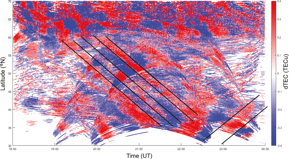
For decades, study of variability in the ITM system has involved elucidating the response to geomagnetic storm forcing, which manifests as sharp impulsive inputs through such events as interplanetary magnetic field reconfigurations associated with coronal mass ejections. (See Appendix B for more details.) Through multiple mechanisms including electrodynamic, composition, and kinetic pathways, geomagnetic storms trigger large and complex perturbations in all ITM state variables on multiple temporal and spatial scales. Understanding this storm-time forcing and its impacts on system response is by no means a closed topic and remains a vital part of community research. Alongside these efforts, the past 2 decades have seen a great deal of additional attention paid toward another vital element in the ITM dynamic picture, through observing and modeling the importance and impacts of transient event influences from the lower atmosphere. These events force significant ITM dynamic wave responses in the form of phenomena such as traveling ionospheric disturbances (TIDs) and traveling atmospheric disturbances (TADs). For example, the massive submarine volcanic eruption of Hunga Tonga–Hunga Ha‘apai drastically increased stratospheric atmospheric water vapor concentrations and generated a large ITM system response, which manifested in part as globally propagating waves (Figure D-2). Additional examples of extreme, impulsive external forcing on the ITM include tsunamis, tornadoes, human events (explosions), coronal mass ejections, and solar flares.
For the study of these extreme events, the current research strategy integrates space-based missions, ground-based instrumentation, theory, and modeling, which are essential to properly elucidate mass, momentum, and energy exchange for these events. For example, NSF CEDAR and NASA’s upcoming DYNAMIC mission study how wave action drives ITM energetics and dynamics, and therefore will capture and measure the impacts on the ITM from extreme and transient events.
Priority Science Goal 1, Objective 1.2: Determine the Time-Varying, Two-Way Electrodynamic Linkages and Mass Flow/Transport Processes Between the Ionosphere, Plasmasphere, and Magnetosphere
Magnetospheric and ionospheric processes (and associated ITM dynamics) are tightly coupled on multiple spatial and temporal scales through a variety of mechanisms. For example, the Birkeland Region 1 upward field-aligned currents (downward electron precipitation) within auroral regions cause conductivity variations that feed back on electron acceleration. Field-aligned heat conduction at subauroral latitudes in the Region 2 field-aligned current (ring current) footprints during storm periods leads to significant ionospheric and thermospheric temperature increases associated with SAR arcs. Electrodynamic feedback mechanisms in the subauroral regions lead to multiple responses. For example, broad (degrees wide) ionospheric flow channels known as subauroral polarization streams (SAPS) carry significant heavy ion mass to cusp outflow regions with subsequent travel out to the
SOURCE: Verhulst et al. (2022), https://www.swsc-journal.org/articles/swsc/full_html/2022/01/swsc220017/swsc220017.html. CC BY 4.0.
inner magnetosphere. Electric fields and currents lead to narrow, highly supersonic ionospheric flows known as subauroral ion drifts (SAIDs) and fine-scale neutral atmospheric responses known as STEVEs.
The current ITM science program implementation strategies reflect the importance of these physical processes. The NSF CEDAR and GEM programs work to understand how Earth’s atmosphere is coupled to its magnetosphere through observations, theory, and increasingly realistic models, and the current NASA Heliophysics strategy focuses on the interaction of the extended solar atmosphere with Earth. NASA’s GDC and DYNAMIC’s multiplane, multi-altitude constellation will observe critically needed information on electromagnetic ITM system inputs and responses at mid- and high latitudes. Mid- and high-latitude incoherent scatter (IS) radars (Millstone Hill, Poker Flat IS Radar [PFISR]/Resolute Bay IS Radar [RISR]) provide local and regional fine-scale altitude-resolved measurements of key ionospheric state variables (electron and ion density, plasma temperature, and plasma drifts) at both subauroral/midlatitudes and high latitudes. Ground-based all-sky imagers and Fabry-Pérot interferometers have long used airglow to study the occurrence and causes of auroral arcs and have recently also studied neutral response to extreme subauroral phenomena such as STEVE.
PSG 1 embraces these space- and ground-based sensing tools and motivates their continued use by affirming and emphasizing the ongoing need to understand the two-way coupling between the ITM, plasmasphere, and magnetosphere. More accurate representation and understanding of this coupling will advance knowledge of the transfer and transformation of mass, momentum, and energy, which pervades the ITM system response to these inputs.
Priority Science Goal 1, Objective 1.3: Determine How the ITM Responds to Lower Atmosphere Forcing on Local and Global Scales
The ITM system has been shown to be extremely sensitive to lower atmosphere forcing, especially during periods of minimal solar activity. The 2013 decadal survey recognized the importance of lower atmosphere forcing on the ITM. However, there remain multiple critical and unresolved issues relating to the impact of
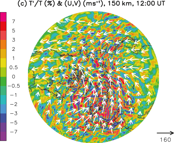
the lower atmosphere on the ITM and how the ITM responds on local and global scales. For example, the state of the stratospheric vortex has been recently shown to significantly alter the composition of the lower thermosphere. Figure D-3 shows the NASA GOLD mission’s observations of O/N2 composition during a sudden stratospheric warming (SSW) event, where O/N2 is depleted during this event. Open questions remain about how the circulation is altered owing to the state of the vortex and how the composition is altered in both latitude and longitude.
A heterogeneous approach to observation and analysis is required to further elucidate the forcing of the lower atmosphere on the ITM system. The current NSF CEDAR strategy, “CEDAR: The New Dimension” (CEDAR 2011), reflects this approach by employing theory, modeling, and observations from both ground-based and space-based platforms to study changes in the whole atmosphere with a strong emphasis on system science. The TIMED mission is an example of a current extended mission that provides a more than 20-year observational baseline for studying the energy transfer into and out of the mesosphere and lower thermosphere. In the next decade, it will be important to make continuity of measurements a priority for the successful closure of this science objective. The upcoming DYNAMIC mission will provide critical information about the forcing from below that comes from waves and tides and, depending on mission configuration, can also separate in situ forcing from upward-propagating tides. Furthermore, the simultaneous availability of DYNAMIC and GDC observations is an essential need for this area through characterizing tides in the 110–250 km “thermospheric gap” (DYNAMIC) at the same time as understanding day-to-day tidal variability and mean state variability with good spatial and temporal coverage (GDC).

SOURCE: Oberheide et al. (2020).
Priority Science Goal 1, Objective 1.4: Elucidate the Mechanisms That Govern the Transition in Chemical, Dynamical, and Thermal Drivers Across the ITM from ~100–200 Kilometers
Within the lower thermosphere and ionosphere, many state parameters within the region between 100–200 km exhibit complex transitions as a function of altitude. For example, one set of tides and waves dominates at the lower end of this altitude range, but a pronounced transition to a different set of tides and waves occurs at higher altitudes, as shown in Figure D-4. The altitude, location, and timing of this transition is still unknown, as well as the processes that govern it. It also remains unclear what the variation in behavior is for this important transition on hourly, daily, and seasonal timescales. Closing these knowledge gaps is critical to forward progress.
Efforts to date have focused on addressing these knowledge gaps in several areas. ITM PSG 1 encompasses NASA’s Heliophysics Division strategy through the science of examining drivers and inputs into the ITM system.
![Height versus latitude distributions of amplitude of zonal wind for Hough Mode Extensions (model) of different tides (DE3 mode [Top], DE2 mode [Middle], and DE1 mode [Bottom]) corresponding to F10.7 = 125 s.f.u. These calculations indicate that different tides should dominate at different altitudes. However, very few relevant observations are currently available.](https://www.nationalacademies.org/read/27938/assets/images/img-406.jpg)
SOURCE: Forbes and Zhang (2022).
NASA’s planned DYNAMIC mission will focus on how wave action alters this transition region through remote sensing techniques. These mission goals directly address PSG 1.4 by affirming the need to understand the chemical, dynamical, and thermal drivers of the 100–200 km transition region. This transition region is also of special interest to the current NSF CEDAR program that employs theory, modeling, and observations from ground-based and space-based platforms to study changes in the ITM. Within the observational portfolio, light detection and ranging (LiDAR) instruments enable investigations of vertical life cycles of small-scale waves as they propagate into, and break within, the mesosphere and thermosphere. PSG 1.4 encourages the further extension of LiDAR technologies to higher altitudes. This capability increases understanding of these small-scale waves and how they transfer energy and momentum throughout the system. To match current and future expanded capability, cutting-edge modeling has focused on how this transition region is modified by and controlled by waves.
Synopsis of Priority Science Goal 1
Advancing ITM system science in the next decade requires a thorough understanding of those influencing factors that flow across both external and internal boundaries. To optimally study ITM system behavior in the areas of transformations and exchanges across these important delineating regions, the panel’s identified science objectives are summarized here:
- Determine the mechanisms of energy and momentum transformation/exchange during and after extreme events (e.g., volcanic eruptions, geomagnetic storms).
- Determine the time-varying, two-way electrodynamic linkages and mass flow/transport processes between the ionosphere, plasmasphere, and magnetosphere.
- Determine how the ITM responds to lower atmospheric forcing on local and global scales.
- Elucidate the mechanisms that govern the transition in chemical, dynamical, and thermal drivers across the ITM from ~100–200 km.
D.3.2 Priority Science Goal 2: How Do Internal ITM Processes Transform Energy and Momentum Across a Continuum of Spatial and Temporal Scales?
The key state parameters of the ITM system exhibit structure over spatial and temporal scales spanning several orders of magnitude (see Table D-1). The largest scales cover a significant fraction of Earth’s circumference. Planetary waves and the diffuse aurora are examples of large-scale phenomena. The smallest scales, exemplified by phenomena such as acoustic waves and plasma turbulence, are cases for which kinetic theory is needed. Between these scales lie mesoscale phenomena such as gravity waves and discrete auroral arcs.
Certain spatial and temporal scales are more efficient pathways for energy and momentum transfer than others. For example, planetary waves generated in the lower atmosphere often dissipate before reaching ionospheric
TABLE D-1 Definitions of Scale Sizes in the Ionosphere–Thermosphere–Mesosphere System with Example Phenomena and Approaches
| Scale Sizes | Small Scale | Mesoscale | Large Scale |
|---|---|---|---|
| Temporal | <1 minute | minutes–hours | >hours |
| Spatial | <1 km | 1–100s km | 1,000s km |
| Example phenomena and approaches |
|
|
|
altitudes. However, nonlinear interactions can imprint planetary-wave signatures upon tides, which propagate to the ionosphere and modulate it with planetary-wave periodicities. Another example is eddy diffusion, which is effective at driving large-scale transport of heat and constituents such as O and NO from the lower and middle thermosphere to the mesopause region. Recombination of O is a major energy source for the mesosphere. Such pathways directly impact the global mean temperature profile and in turn atmospheric stability and the upward propagation of waves. For these reasons, understanding vertical atmospheric coupling is not possible without understanding how wave energy and momentum are transformed across scales. These are just two of many examples, discussed below, that support the notion that bidirectional feedback across scales—a process known as “cross-scale coupling”—is a critical element of ITM system science.
For many important processes, cross-scale coupling is mediated by mesoscale processes. For example, gravity wave propagation is regulated by large-scale background flows associated with tides and planetary waves, while gravity wave dissipation drives global circulation and seasonal temperature changes in the mesosphere and lower thermosphere (MLT). Another example is the coupling of the magnetosphere and ionosphere: small-scale precipitation structures generate ionization, which is advected by high-latitude convection, yielding meso-scale conductivity enhancements that feed back to modulate global distributions of electric potential, field-aligned current, and precipitation. The role of mesoscale processes in transforming energy and momentum in the ITM is a significant knowledge gap to be addressed in the next decade.
A challenge for understanding cross-scale coupling is that no single investigative technique is suitable for all scales. For example, incisive vertically resolved observations, which are required to understand energy and momentum transfer, are often available only from isolated ground-based facilities or single-spacecraft missions and cannot observe the global drivers or responses. The modeling challenge is that it has been numerically impractical to capture realistic small-scale gravity wave effects or plasma irregularities in global first-principles models. Also, these models are inherently limited by the availability of high-resolution data for assimilation and validation. Overall, progress on cross-scale coupling has been hampered by siloed investigations and insufficient coordination of expertise.
The importance of cross-scale coupling for ITM science has been recognized for many years. The 2013 decadal survey AIMI report recognized that “cross-scale coupling processes are intrinsic to atmosphere-ionosphere-magnetosphere behavior.” AIMI Science Goal 4 (“How do neutrals and plasmas interact to produce multiscale structures in the AIM system?”) addresses one of many fundamental processes, ion-neutral coupling, which plays a significant role in ITM structure and evolution on local, regional, and global scales. However, the AIMI strategy did not explicitly promote investigations into coupling across spatial scales, nor did it recognize the importance of temporal cross-scale coupling. Cross-scale coupling is an explicit element of the systems science perspective expressed in “CEDAR: The New Dimension.” Grassroots, community-led efforts have been dedicated to cross-scale coupling via multiyear conference sessions, including an NSF CEDAR Grand Challenge. Part of the motivation for the NSF Distributed Array of Scientific Instruments (DASI) program is the need to observe multiple scales simultaneously. The Diversify, Realize, Integrate, Venture, Educate (DRIVE) Science Centers are beginning to enable the larger team structures needed to analyze and model cross-scale coupling problems in the ITM.
The following sections describe specific scientific objectives identified by the panel within PSG 2 for which significant progress can be achieved in the next decade.
Priority Science Goal 2, Objective 2.1: Determine How the Gravity Wave Spectrum Cascades Throughout the Thermosphere and Impacts the ITM System
Gravity waves from the lower atmosphere significantly modulate the mean state and variability of the ITM. The classic example is the apparent paradox of the summer mesopause being the coldest place in the Earth system. Although solar radiative heating is stronger in the summer, the summer hemisphere is adiabatically cooled owing to the strong summer-to-winter circulation driven by gravity wave dissipation, serving as an example of meso-tolarge-scale energy transfer. Gravity wave energy can also cascade to smaller scales, driving turbulence. Turbulent mixing in the lower thermosphere controls the vertical profiles of chemical constituents like atomic oxygen and determines the thermal structure of the ITM. Gravity waves that reach the ionosphere can generate TIDs and potentially seed plasma instabilities such as equatorial spread F.
SOURCE: Becker et al. (2022).
Gravity wave amplitudes grow with height, a consequence of the conservation of momentum as the neutral density decreases. They can become unstable and break via gravity wave, mean-flow, and nonlinear interactions. This wave breaking is thought to lead to the secondary generation of waves that propagate to higher altitudes. In the thermosphere, this process might repeat in a process known as “multistep vertical coupling.” Figure D-5 shows predictions from a mechanistic model of secondary and higher-order gravity waves permeating the winter thermosphere. The relative importance of primary and higher-order gravity waves is still not well understood, and observations of these processes at work remain exceedingly sparse. Whole atmosphere numerical models of these processes are also not yet comprehensive, as they currently either do not include gravity waves or include only a crude parameterization of their effects because there are not enough observations. For instance, some large models are beginning to explicitly simulate gravity waves, but to date only at large scales (≳200 km).
Observational challenges also remain in this area, depending on the technique used. Gravity wave observations have been mostly limited to nighttime and to the lowest altitudes in the ITM (~85–100 km), via ground-based airglow imagery. These observations can target specific airglow emission lines that originate from different altitudes to provide maps of gravity wave propagation. However, the current observation network provides sparse global coverage and is subject to ambiguities associated with their line-of-sight integrated nature. There are promising avenues emerging to address the situation, in the form of networked multistatic meteor radar sites, which are beginning to yield gravity wave characterizations in a limited altitude range (80–100 km). Gravity waves and wave–wind interactions have been observed by LiDARs, albeit with a limited vertical range and at single-point ground facilities. Gravity wave effects on plasma dynamics (e.g., TIDs) are relatively well observed by radars, ionosondes, and networked global navigation satellite system (GNSS) measurements of total electron content (TEC). These instruments observe the dynamic effects of waves modulating the plasma. Nevertheless, the network sensor distribution remains insufficient to comprehensively understand the full range of longitudinal and local time dependence. Observations in the critical 100–200 km region remain extremely rare.
Modeling gravity wave generation and impacts also remains an active and ongoing challenge, because there is not yet a universally understood and elucidated set of mechanisms for wave vertical propagation and their manifestation. For example, the vertical propagation of the spectrum of waves generated by the recent Hunga Tonga–Hunga Ha‘apai volcanic eruption in January 2022 is currently serving as a test case for understanding vertical wave coupling. While observed perturbations in the lower atmosphere have been understood as manifestations of the Lamb wave mode, debate is ongoing over the pathways that caused disturbances observed in the ionosphere.

SOURCE: Vadas et al. (2023).
Vadas et al. (2023) have argued that the large thermospheric waves are secondary gravity waves generated by the dissipation of the primary waves from the eruption (Figure D-6). Alternatively, Liu et al. (2023) suggest that the L1’ Lamb pseudomode may be important for understanding the thermospheric signature (Figure D-7). Resolving the relative importance of these mechanisms will rely in the future on more comprehensive observational databases at altitudes between the mesopause and the ionosphere.
No previous NASA missions have directly targeted gravity wave science. Serendipitous observations of thermospheric gravity waves in the daytime were made by ICON Michelson Interferometer for Global High-resolution Thermospheric Imaging (MIGHTI), but only for long wavelengths (≳1,000 km). GOLD conducts rare special campaign modes to observe gravity waves in the disk ultraviolet radiance. Recently launched mission Atmospheric Waves Experiment (AWE) and upcoming GDC will address gravity waves and their effects, but only

SOURCE: Liu et al. (2023), https://doi.org/10.1029/2023GL103682. CC BY.
with snapshots at the upper and lower boundaries. The AWE mission will investigate how gravity wave breaking is influenced by background fields and how momentum deposition then influences the wave field. However, AWE will observe 30–300 km scales only at a single altitude (the OH emission altitude ~87 km) and thus will not address cross-scale coupling or global ITM impacts. GDC will make observations of TIDs and TADs in situ (~400 km) but will not address cross-scale coupling. For these reasons, the panel finds that the vertical life cycle of gravity wave momentum and energy is a key knowledge gap to be addressed in the next decade.
Priority Science Goal 2, Objective 2.2: Determine How Small-Scale Structuring in High-Latitude ITM State Parameters Leads to Mesoscale Conductivity Enhancements That Have Aggregate Global Significance
Small-scale filamentary current structures at high latitudes produce significant local heating and ionization. These structures are embedded within regional-scale and global-scale flow fields that convect the newly ionized or heated gas into undisturbed regions. In turn, these sources modify the global ionospheric conductivity at mesoscales. These modifications of ionospheric conductivity can have global effects, and Figure D-8 depicts how

SOURCE: Reprinted from C. Gabrielse, S.R. Kaeppler, G. Lu, C.-P. Wang, and Y. Yu, 2021, “Energetic Particle Dynamics, Precipitation, and Conductivity,” pp. 217–300 in Cross-Scale Coupling and Energy Transfer in the Magnetosphere-Ionosphere-Thermosphere System, Y. Nishimura, O. Verkhoglyadova, Y. Deng, and S.-R. Zhang, eds., Copyright (2021), with permission from Elsevier.
modeled potential and field-aligned current patterns can vary dramatically depending on the nature of the input conductance patterns.
The data-driven result in Figure D-9 relied on Polar UVI’s full-oval imaging, a capability that has not been available since 2005. Partially filling this measurement gap are ground-based all-sky camera arrays (e.g., Themis ground-based observatory [GBO]), which are suited for investigating arc-scale to regional-scale relationships, but observations are available only at night and only when conditions permit (e.g., during clear skies, new moon phase, and low aerosol levels). Past CEDAR efforts, as well as the European LOcal Mapping of Polar ionospheric Electrodynamics (LOMPE), have combined imagery with magnetometer chains and Super Dual Auroral Radar Network (SuperDARN)/IS radar data to investigate high-latitude cross-scale coupling. However, these successes were not part of a current U.S. research strategy, but instead via international, ad hoc, and often unfunded grassroots efforts.
Electronically scannable IS radars (Advanced Modular IS Radar [AMISR], European IS Scientific Association [EISCAT] 3D) provide vital common-volume measurements across multiple spatial scales nearly simultaneously. Other radar techniques (ionosonde, SuperDARN/high-frequency [HF] radar) also provide compelling measurements with different individual strengths, but they require joint rather than individual analysis to address cross-scale coupling. Meanwhile, whole geospace models (e.g., the Multiscale Atmosphere–Geospace Environment [MAGE] model developed as part of a NASA DRIVE center) have the potential for transformative insights into high-latitude, cross-scale coupling. Such models can self-consistently account for cross-scale, magnetosphere–ionosphere–thermosphere coupling processes.
GDC will provide critical surveys of the spatial scales and persistence times of various phenomena associated with the ITM’s response to solar and magnetospheric energy inputs. The phased deployment of the constellation will allow a valuable investigation of individual scales sequentially. However, beyond GDC, coincident observations at various scales remain necessary to assess cross-scale coupling. The upcoming “small mission” Electrojet Zeeman Imaging Explorer (EZIE) (Class D) will investigate current closure at small scales, instantaneously.

NOTE: UFKW, ultra-fast Kelvin wave.
SOURCE: Nystrom et al. (2018).
However, EZIE will address cross-scale coupling phenomena only on a restricted regional scale, not globally. In summary, the panel finds that high-latitude, cross-scale coupling mediated by mesoscale conductivity variability is a key knowledge gap for the coming decade.
Priority Science Goal 2, Objective 2.3: Determine How Nonlinear Coupling Between Mean Neutral Atmosphere Circulation, Tides, and Planetary Waves Drives ITM Variability
A significant amount of observational and theoretical work over the past decade has improved the understanding of how global-scale waves (i.e., tides, planetary waves, and tropical waves) from the lower atmosphere force the ionosphere–thermosphere system. There is direct forcing by penetration into the thermosphere that modifies the chemistry and field-aligned drag, and indirect forcing by altering the neutral wind dynamo. The amplitude of these waves is often nonnegligible relative to the background, in which case second-order terms are important and propagation is nonlinear. This allows for the transfer of wave momentum and energy between different spatial and temporal scales, which can drive a rich spectrum of ITM variability.
The modeling results in Figure D-9 suggest that child waves from nonlinear interactions between primary waves may produce half of the variability of the primary waves at 120 km. Observational evidence for these waves is extremely scarce, often consisting of observations below 100 km, or observations of the plasma response at ~300–400 km, but with little information on the pathways by which these signatures reach the ionosphere. A major observational challenge is that child waves can alias with primary waves in single-spacecraft observations from low Earth orbit (e.g., ICON and TIMED). Full-disk observations from high altitudes (e.g., GOLD) ameliorate aliasing issues, but such remote sensing observations are inherently integrated along the viewing line of sight and are not directly altitude-resolved.
While GDC and DYNAMIC will be foundational for moving this science forward, the missions may still be limited in their ability to completely address nonlinear wave–wave coupling. The DYNAMIC mission is likely to address some aspects of vertically resolved cross-scale coupling within the mesosphere/lower thermosphere, depending on the selected configuration. If DYNAMIC is operated simultaneously with GDC, it will be possible to trace the effects of some wave–wave coupling processes on the middle/upper thermosphere/ionosphere. These contributions will be valuable but inherently limited—for example, if the DYNAMIC budget limits the implementation to two flight elements, it will be difficult to resolve semidiurnal or higher-order tides on subseasonal timescales. Ground-based meteor radar systems distributed around the globe have the potential to provide critical observations of the global neutral wind distribution, but only from ~80 to 100 km.
In aggregate, global-scale wave–wave/mean-flow coupling is a key knowledge gap for understanding ITM variability in the next decade. PSG 2.3 is not necessarily independent of PSG 2.1, because wave–wave coupling processes can include gravity waves. Indeed, the steep wind shears that can cause sporadic E layers are thought to arise from gravity wave/tide interactions. Another example is stratospheric sudden warmings, in which large-scale variations in the polar vortex interact with tides and gravity waves to produce global-scale ionospheric disturbances.
Priority Science Goal 2, Objective 2.4: Determine How Plasma Irregularities Are Driven by and Regulate Large-Scale ITM Phenomena
Plasma turbulence is a frontier of theoretical physics but also has numerous direct applications to heliophysics. Small-scale Kelvin-Helmholtz instabilities are generated by, and subsequently regulate, large-scale and mesoscale flow shears that likely control system-level and emergent behavior of fine-scale flow channels such as SAIDs, and their visible signatures known as STEVEs. The auroral convection pattern has mesoscale variability cascading into small-scale instabilities embedded within its synoptic pattern. Farley-Buneman (cross-streaming) instabilities interact with and limit large-scale flow differences between species. Interchange instabilities (e.g., Rayleigh-Taylor) are associated with large-scale equatorial plasma bubbles, an important space weather phenomenon. The potential seeding of bubbles by gravity waves is still being debated. Plasma instabilities causing 150 km echoes are a nearly 30-year mystery recently hypothesized to be driven by coupling between the upper hybrid instability and background photoelectrons, possibly modulated by gravity waves (Figure D-10).

SOURCE: Lehmacher et al. (2019).
With some exceptions, irregularity science has focused mostly on processes occurring at the equator (e.g., using the Jicamarca Radio Observatory IS radar) and in auroral/polar regions (e.g., polar cap patches), but large-scale features that can drive instabilities through cross-scale coupling occur across all latitudes. Electronically scannable IS radars have contributed (AMISR) or will contribute (EISCAT 3D) critical observations of multiple scales simultaneously in regional fields of view. Other radar techniques (ionosonde, SuperDARN/HF radar) also provide compelling measurements with different individual strengths. But to comprehensively address cross-scale coupling between irregularities and large-scale ITM phenomena, measurements and expertise at different scales need to be brought together.
In addition to theoretical treatments and bespoke numerical models, general-purpose high-resolution regional modeling of plasma irregularities and plasma-neutral interactions have captured some cross-scale coupling phenomena. Advances in techniques such as adaptive mesh refinement could enable further progress. The panel finds that understanding of the generation of plasma irregularities and their interaction with larger-scale ITM phenomena is a key knowledge gap for the coming decade.
Synopsis of Priority Science Goal 2
In concert with transport across physical boundaries and transition regions (see PSG 1), the internal exchange of energy and momentum across all spatial and temporal scales, including the vitally important mesoscale range, is a fundamental process whose understanding is essential for ITM system science in the next decade. Accordingly, optimal study of ITM system behavior in energy and momentum dynamics requires effort on the panel’s identified science objectives, summarized here:
- Determine how the gravity wave spectrum cascades throughout the thermosphere and impacts the ITM system.
- Determine how small-scale structuring in high-latitude ITM state parameters leads to mesoscale conductivity enhancements, which have aggregate global significance.
- Determine how nonlinear coupling between mean neutral atmosphere circulation, tides, and planetary waves drives ITM variability.
- Determine how plasma irregularities are driven by and regulate large-scale ITM phenomena.
D.3.3 Priority Science Goal 3: Quantitatively, What Is the Relative Significance of Competing Physical Processes That Govern the ITM State and Its Variability?
The ITM is an interconnected system whose response to its multiple drivers can be characterized by nonlinearity and instability, feedback, preconditioning, and emergent behavior. The evolution of the dynamic ITM state (plasma and neutral density, composition, temperature, and velocity) is governed by the continuity, momentum, and energy equations and their derivative terms, which are nonlinear and can be coupled across multiple scales. While the theory that supports data analysis and numerical modeling is well established, quantitative knowledge regarding the numerous driver/response relationships and their relative significance under different conditions (spatial, climatological, temporal) is underconstrained.
The complexity and interconnectivity of the ITM system can lead to interpretations that rely on observed correlations rather than on underlying physical causal links. One such example is the early interpretation of the cause of the Weddell Sea Anomaly, in which the midnight electron density can exceed the midday electron density by a factor of 2 in the Southern Pacific Ocean in the summer. Because of the correlation with the particular magnetic field declination and inclination in this region, the phenomenon was long attributed to the action of neutral winds. Recent analyses with a model that was constrained by key satellite data showed that the neutral composition is a much more important driver of anomalous electron density than wind effects. This example demonstrates the importance of having sufficient data to constrain important model parameters to determine which ones are most effective. Quantifying the relative significance of competing physical processes, as in this example, is a critical step in system science development, leading to full physical understanding as well as predictive capabilities.
A system-level understanding of the ITM requires moving from correlation-based conclusions to the identification of fundamental causative mechanisms. Such a definitive determination is predicated on accurate and precise quantification of the relative significance of competing physical processes. A system-level understanding of the ITM also must establish baseline behavior to enable both the recognition of emergent behavior as well as the assessment of the sensitivity of a response to the specific nature of background conditions.
Both the 2013 decadal survey and the 2011 NSF CEDAR Strategic Plan (CEDAR 2011) introduced system science, particularly system identification, as a valuable framework for ITM science. The 2013 decadal survey recognized the strong role that modeling and theoretical analysis play in advancing a system science approach, specifically noting that comprehensive models of the AIM system would benefit from “developing assimilative capabilities” and “the development of embedded grid and/or nested model capabilities, which could be used to understand the interactions between local- and regional-scale phenomena within the context of global AIM system evolution.” It also noted that “Complementary theoretical work would enhance understanding of the physics of various-scale structures and the self-consistent interactions between them.” The 2013 decadal survey recommended the implementation of a multiagency initiative, DRIVE, to more fully develop and effectively employ the many experimental and theoretical assets at NASA, NSF, and other agencies to address the need for multidisciplinary data and model integrated investigations of fundamental physical processes.
The proposed PSG 3 supporting strategies in this new decadal survey build on these initiatives and focus future scientific efforts on establishing quantitative, causal links between ITM processes, rather than correlative relationships of unknown significance. The following sections describe specific scientific objectives identified by the panel within PSG 3 for which significant progress can be achieved in the next decade.
Priority Science Goal 3, Objective 3.1: Quantify the Relative Roles of Preconditioning and Seeding Mechanisms in Controlling the Emergence and Evolution of Ionospheric Irregularities
Ionospheric density irregularities are the major source of naturally occurring disruptions of radio frequency transmissions. They span several orders of magnitude in spatial scales (centimeters to hundreds of km) and exhibit
strong day-to-day, seasonal, and longitudinal dependencies. While most common at low latitudes and high latitudes, recent research has shown that there are midlatitude fluctuations measurable through rate-of-TEC variations. At high latitudes, convection and auroral precipitation are associated with scintillations. A number of different plasma instability mechanisms—gradient drift, Kelvin-Helmholtz, temperature gradient instability—are thought to contribute but perhaps to differing degrees in different circumstances.
At low latitudes, the orientation of the magnetic field lines and the interaction of plasma with neutrals may play a significant role in seeding irregularities, although many open questions remain regarding cause and effect. The competing physical mechanisms that govern the initiation, growth, and suppression of equatorial plasma bubbles (EPBs) are not well understood. At low latitudes, potential seeding mechanisms (such as gravity waves), tropospheric events (such as lightning flashes), traveling ionospheric disturbances, prompt penetration electric fields, and the disturbance dynamo have been proposed. There are climatological controlling factors, such as orientation of the terminator with respect to magnetic meridian, and variable factors, such as neutral winds and global electric fields.
On many nights, low-density plasma bubbles emerge from the lower F-region ionosphere and rise quickly to altitudes of 1,000 km, often becoming very turbulent and leading to dramatic height versus time intensity variations. Satellite-based communication and navigation may be disrupted, such that predicting these conditions is an important goal of space weather research.
Past missions that have been used to observe the ITM state during scintillation occurrence include Communications/Navigation Outage Forecasting System (C/NOFS), Constellation Observing System for Meteorology Ionosphere and Climate (COSMIC), COSMIC-2, Defense Meteorological Satellite Program (DMSP), GOLD, ICON, Scintillation Observations and Response of the Ionosphere to Electrodynamics (SORTIE), and Swarm. Satellite-based measurements of in situ conditions and associated GNSS loss of lock have played a role in underscoring the space weather import of this question. As an example, Figure D-11 maps the global occurrence of GPS loss of lock for the Swarm A LEO satellite. Combining the satellite observations with ground-based observations has enabled consideration of both the plasma and neutral states during instances of EPBs. Large ground-based facilities, such as Arecibo and Jicamarca, and networks of distributed ionospheric sensors, such as Low-Latitude Ionospheric Sensor Network (LISN), have been key to obtaining these observations.
The relative abundance of scintillation data with even one scintillation receiver, or derivable from a distributed network, has been an impetus for recent initiatives in leveraging data science methods, including artificial intelligence and machine learning. At least one NASA Living With a Star (LWS) Focused Science Team has addressed scintillation-related topics.
One of the challenges with modeling EPBs is the multiple scales and multiple possible phenomena to investigate. There are multiple models that address different possible seeding mechanisms, some that are well equipped to handle global tides and waves, others that model ionospheric plasma, and still others that work at the instability mechanism scales themselves, either modeling the linearized growth rates or directly simulating irregularity development from first principles. Progress has been made in vertically coupling lower atmosphere models to propagate midlatitude convective weather systems up to the thermosphere. These have qualitative similarities to simultaneous traveling ionospheric disturbances (TID) observations, but more cross-model coupling including for different scale sizes is needed to begin to address the seeding mechanism question quantitatively. A developing capability in modeling is emerging bringing multiple models together to cross the scale sizes and boundaries (PSGs 1 and 2). Figure D-12 is an example that points the way: high-resolution models that are one-way coupled (left and middle) bear a striking resemblance to GOLD observations (right).
However, these models are coupled from WACCM-X to SAMI3 (one-way) at present. After adding vertical and multiscale coupling in models, these model outputs then must be further coupled to electromagnetic propagation to show the beginning-to-end connection to scintillation observations. Geospace Environment Model of Ion-Neutral Interactions (GEMINI)+ Satellite-beacon Ionospheric-scintillation Global Model of the upper Atmosphere (SIGMA) modeling is one such example. Further progress is needed in coupling the models, and the question then arises as to whether they will be able to produce enough fidelity to reproduce observations and allow quantitative single comparisons to be made. Because turbulence has elements of a random phenomenon, quantitative measures of significance will need to be developed statistically, which requires many more model outputs than are currently produced, at levels far beyond case studies.

SOURCE: Xiong et al. (2016).

SOURCES: (Left and Middle Panels) Huba and Liu (2020); (Right Panel) Eastes et al. (2019), https://doi.org/10.1029/2019GL084199. CC BY.
While progress has been made in data assimilation at global scales in the past decade, including the quantification of uncertainties, none of these assimilative methods operate at scintillation scales. There are no first-principles instability models that can assimilate scintillation measurements. For existing data assimilation techniques, incorporating new measurements from the GDC, DYNAMIC, and AWE missions will help connect the coupling mechanisms. The ENLoTIS (European Space Agency [ESA]/NASA Lower Thermosphere–Ionosphere Science) mission concept could provide comprehensive EPB dynamic features along with their driver measurements, combined with data from small satellite platforms. In particular, continued observation of EPBs, their possible triggering parameters, and the resultant scintillations must be made in order to feed quantitative assimilation solutions for a case-by-case mapping that will unlock progress in cause and effect understanding.
Priority Science Goal 3, Objective 3.2: Quantify the Relative Significance of Competing Drivers of Day-to-Day Variability in the ITM System
Day-to-day variability in the ITM system can arise from changes in several factors. Many competing drivers of the observed variability in the neutral wind field in particular have been identified, including auroral energy deposition, electric fields, gravity wave breaking, nonlinear interactions among various wave types, and ion-neutral coupling. Currently, the predictability of the seasonal, diurnal, and solar cycle variability of neutral winds is poorly characterized because the data sets are too sparse, and the model drivers are not adequately characterized. In addition, the effect of preconditioning on these drivers and the observed mesoscale variability is not well understood.
An ultimate aim is to develop physics-based and assimilative models to accurately predict ITM day-to-day variability (weather) far in advance, similar to tropospheric forecast models. The neutral wind field in the mesosphere and thermosphere exhibits significant temporal variability on timescales of hours to days, even in the quietest geomagnetic conditions. Figure D-13 depicts output from a high-resolution global model simulation that illustrates the type of variability in vertical winds that is caused by orography and tropical cyclones. This variability results in day-to-day modification of the ionosphere electron density. In contrast to tropospheric weather forecasting capability, current physics-based and assimilative models are unable to accurately predict ITM weather conditions.
Recent ITM missions were successful in exploring specific processes. ICON investigated various drivers (composition, neutral winds, dynamo electric fields) and their relative importance to ionospheric variability, but only on large spatial (global) and temporal (seasonal) scales. TIMED characterized the MLT energy budget and quantified contributions to thermospheric cooling.

SOURCE: Liu et al. (2014).
GDC and DYNAMIC are well suited to address important PSG 3 problems through their planned strategic coordination. Through simultaneous operation, they will explore elements of system-level quantification, including the origins and impacts of day-to-day variability. Ground-based observations from IS radars, ionosondes, SuperDARN HF convection radars, neutral airglow Fabry-Pérot instruments, all-sky imagers, and related network efforts also will continue to provide important local and regional/continental scale measurements of ITM variability in a fixed local time sensor view, especially when coordinated with the complementary picture determined from in situ satellite platforms.
Most past and current modeling efforts have insufficiently addressed model output uncertainties and their sensitivity to external (e.g., solar EUV, auroral precipitation) and internal parameters (e.g., reaction rates, cross sections). The recent NSF Space Weather Quantification of Uncertainties program is aimed at creating space weather models with quantifiable predictive capabilities through advancing modeling approaches and the proper treatment of observational inputs.
Some instruments provide inherent quantification of uncertainty on the retrieved state parameters, but often the error analysis is ad hoc. Results are often reported without appropriate treatment of either measurement/retrieval uncertainty or systematic bias associated with physical assumptions of the retrieval approach. The need for robust uncertainty quantification (UQ) has been established in the applications community (e.g., space weather forecasting), but UQ is just as important for scientific understanding of ITM system variability.
Priority Science Goal 3, Objective 3.3: Quantify the Most Salient Factors Governing the Global ITM Response During and Following Geomagnetic Activity
The ITM response to geomagnetic storms has been a topic of study for several decades, and substantial recent progress in understanding individual mechanisms has been made by missions such as TIMED, GOLD, and ICON,
as well as by ground-based assets such as IS radars, LiDARs, and optical observations. Many competing drivers contribute to the ITM response to magnetic storms, including neutral winds, electric fields, energetic particle precipitation, neutral temperature, and composition (O, N2, and NO) changes. However, the relative importance of various controlling mechanisms of the system behavior is not well established. Quantifying the relative importance of these factors is crucial to understanding the storm-induced changes in the ITM system.
For example, both ICON and GOLD satellite observations have revealed large effects in multiple ionospheric and thermospheric parameters, which exhibit significant spatial structure even at midlatitudes, following even very weak storms (see Figure D-14). The patchy nature of the midlatitude thermosphere composition response to a storm illustrates why predicting magnetic storm effects is difficult and why global-scale sensing is so important. Progress has been hampered by insufficient temporal and spatial resolution of the observations. Numerical advances such as whole geospace and assimilative models are developing quickly and will be excellent tools for further progress when combined with appropriate data sources.
A major impediment to a better understanding of ITM behavior during and after a storm event is that they rarely have similar characteristics. The lack of good storm indices and the necessary averaging of the thermosphere response data help explain why the Naval Research Laboratory Mass Spectrometer and IS Radar Exosphere (NRLMSISE-00) empirical model is much less reliable during disturbed times than during quiet times. Likewise, quantifying the auroral energy input with its high temporal and spatial variability is a key problem for physics-based models. Another uncertainty is the vibrational distribution of N2, which has a major effect on the ionosphere density by increasing the O+ loss rate during elevated levels of magnetic and solar activity. Although the vibrational state of N2 can be well modeled, its calculation is very computer intensive and has not yet been included in global models. This can lead to overestimation of the F-region electron density by a factor of 2. Resolving these difficulties to further advance modeling capability needs to incorporate simultaneous images of both north and south auroral regions, coupled with in situ measurements and comprehensive ground-based measurements in both hemispheres. Such multielement analysis approaches have proved quite productive in the recent past for similar challenges; for example, a major improvement in storm modeling was achieved by including conductance patterns derived from the Polar UVI auroral images together with ground magnetic perturbations that include mesoscale structure.

SOURCE: Cai et al. (2020).
Priority Science Goal 3, Objective 3.4: Quantify the Origin of Interhemispheric Asymmetries in Geospace and Their Effects on the ITM System
Interhemispheric asymmetry in current circuits, particle precipitation, and electron density is now understood to be a common feature of global and mesoscale ITM structure and variability, and Figure D-15 illustrates an example of this phenomenon. Conjugate asymmetries are believed to arise from both intrinsic ITM factors (e.g., the geomagnetic field, ionospheric conductivity, atmospheric waves) and external factors (e.g., the solar wind and magnetospheric forcing). Investigating the nature and origin of interhemispheric asymmetries in global and mesoscale structures offers critical tests of our understanding of the ITM system response to competing drivers.
The magnetosphere–ionosphere–thermosphere–mesosphere system regulates Earth’s global current circuit, highlighting the critical importance of ionospheric conductivity. A number of ITM processes that govern structure in conductivity (Joule heating, transport, precipitation, composition) compete to regulate, for instance, the substorm cycle for different situations. How the global current circuit influences ITM system behavior, and how the ITM system regulates the global current circuit, are the net results of the balance of a number of competing processes. A complete understanding of this ITM system regulation will be valuable through its ability to explain and predict the effects of interhemispheric asymmetries (and symmetries/magnetic conjugacy) in energetic particle precipitation, currents, and flows.
Many existing resources have contributed to the understanding of these questions so far. Ad hoc conjunctions of ground-based auroral imagery arrays (THEMIS-GBO) with satellite data (ESA-Swarm, DMSP) and radar data (PFISR, RISR, EISCAT) have supported investigations of storm-time ITM system dynamics in high-latitude regions, although primarily confined to the northern hemisphere. Meanwhile, magnetometer chains across Canada, Alaska, and Scandinavia provide models with continuous and distributed data constraints needed for a variety of studies.
Directed research programs have also focused on some of these questions. For example, NSF CEDAR Grand Challenge studies have included “Interhemispheric Asymmetries (IHA) and Impact on the Global I-T System” (2023), “Multi-Scale I-T System Dynamics” (2021), and “The High Latitude Geospace System” (2016). Recently, assimilative tools such as LOMPE allow the aggregation of heterogeneous data sets into maps of information that can be used to drive models. Larger-scale similar tools such as Assimilative Mapping of Ionosphere Electrodynamics (AMIE) have significantly contributed to these studies.
However, much of this recent progress has relied on ad hoc conjunctions and collaborations. With dedicated and strategic coordination of new and existing measurement and modeling assets, the community is poised for much larger advances toward this important science priority.

SOURCE: K.M. Laundal and N. Østgaard, 2009, “Asymmetric Auroral Intensities in the Earth’s Northern and Southern Hemispheres,” Nature 460:491–493, https://doi.org/10.1038/nature08154, reproduced with permission from SNCSC.
Synopsis of Priority Science Goal 3
The efforts of PSG 1 and PSG 2 will identify important physical ITM processes both internally and across system boundaries under a range of geophysical conditions. However, it is also essential that the relative significance of these processes is understood within these ranges, including preconditioning effects, to solidify understanding of which system pathways compete and contribute to dynamic control and how these pathways change roles across variable conditions. Such knowledge is foundational to efforts to understand, to model, and ultimately to predict the nature and variety of ITM dynamics. It also fosters a more complete understanding of the ITM system through identification of fundamental causative mechanisms along with baseline behavior, sensitivity to external drivers, and emergent processes. Optimal study of ITM behavior and the identification of relative significance and consequences of competing physical system processes in the next decade thus involves the panel’s identified science objectives, summarized here:
- Quantify the relative roles of preconditioning and seeding mechanisms in controlling the emergence and evolution of ionospheric irregularities.
- Quantify the relative significance of competing drivers of day-to-day variability in the ITM system.
- Quantify the most salient factors governing the global ITM response during and following geomagnetic activity.
- Quantify the origin of interhemispheric asymmetries in geospace and their effects on the ITM system.
D.3.4 Priority Science Goal 4: How Does Earth’s ITM System Respond to Persistent Changes in the Geospace Environment?
As illustrated by many of the preceding examples, Earth’s ITM system is highly dynamic, capable of simultaneously exhibiting day-to-day variability, large transient responses to impulsive perturbations, and climatological periodicities on diurnal, seasonal, and solar cycle timescales. Over the past few decades, it has become clear that the ITM is also undergoing secular evolution on much longer timescales. Several key ITM state parameters, such as total atmospheric mass density and temperature, have been observed to be slowly but significantly deviating from their historical ranges associated with sporadic and climatological variability. Physics-based modeling suggests that these changes are occurring primarily in response to anthropogenic increases in atmospheric CO2 and methane. However, as described further in the section “Priority Science Goal 4, Objective 4.2,” the response of the ITM system to Earth’s climate evolution is highly complex, involving not only temperature and density variations but also changes in mesospheric chemistry, gravity wave generation, atmospheric circulation, and more.
In the next decade, new anthropogenic changes in the ITM are likely to occur in response to the planned deployment of mega-constellations of satellites as well as potential geoengineering initiatives for radiation management, such as stratospheric aerosol injection. Meanwhile, the ITM is strongly influenced by persistent changes in its natural system drivers, such as the accelerating reconfiguration of Earth’s intrinsic magnetic field or extended periods of unusually weak or strong solar activity and irradiance (see the section “Priority Science Goal 4, Objective 4.1”). Although current trends appear to be gradual, complex dynamical systems like the ITM can experience large, abrupt, and often irreversible transitions between stable dynamical states when driven beyond critical thresholds (tipping points). Earth’s global climate system is widely considered to be approaching numerous tipping points in the coming decades, and dynamical state transitions can occur in response to even small changes in tightly coupled system drivers. Understanding the nature, origin, and effects of the ITM response—whether slow or sudden—to persistent changes in its various drivers—whether natural or anthropogenic—is a critical aspect of understanding Earth’s ITM as a coupled dynamical system.
Advancing current understanding of Earth’s upper atmospheric state evolution is the focus of the ITM panel’s PSG 4 for the coming decade. This priority builds on the 2013 decadal survey, specifically AIMI Science Goal 5 (“How is our planetary environment changing over multidecadal scales, and what are the underlying causes?”), which explicitly recognized the fundamental importance of geospace evolution. PSG 4 also builds on “CEDAR: A New Dimension,” whose Strategic Thrust 3 set forth a mission “To understand and predict evolutionary change in the geospace system and the implications for Earth and other planetary systems” (CEDAR 2011). Much progress
has been made toward these strategic goals in the past decade, through both rigorous analysis of historical ITM measurements as well as whole atmosphere numerical simulations driven by extreme conditions.
However, current assessments of secular ITM trends are based primarily on uncoordinated data of opportunity rather than systematic and strategic investigation. Moreover, the past decade’s focus on slowly evolving trends overlooks the potential for relatively rapid transitions in either ITM drivers or its response. Identifying the limits of dynamical ITM stability and assessing the impacts of potential tipping points are particularly unexplored and important areas of research. The following sections describe specific scientific objectives identified by the panel within PSG 4 for which significant progress can be achieved in the next decade.
Priority Science Goal 4, Objective 4.1: Determine How the ITM Is Influenced by Slowly Evolving Trends in Its Natural System Drivers
The ITM system is driven predominantly by the conditions of the natural environment in which it is embedded—namely, solar radiation controls ionization and heating; the interaction of the solar wind and interplanetary magnetic field with the magnetosphere generates high-latitude ionospheric current systems and induces plasma transport; and these, together with lower atmospheric conditions, influence atmospheric chemistry and dynamics. While these natural drivers exhibit both sporadic variability and climatological periodicities, some also evolve on decades-long timescales, with large effects on the quasi-equilibrium state of the ITM system.
A well-known example of long-term changes in natural ITM forcing is the unusually deep solar minima that occurred in 2009 and 2019, along with the muted solar maximum in between. Continuing a trend of weakening solar activity seen over the past four solar cycles (Figure D-16), Solar Cycle 24 was the weakest cycle in more than 100 years, in addition to being relatively short at only 10 years. Historically, relatively weak solar cycles are rare but not unprecedented, even in series (the Dalton Minimum). Deep solar minima are more common, and a very long period of extreme dormancy (the Maunder Minimum) occurred over the 400-year sunspot data record. Solar Cycle 25, which is expected to peak in 2025, is already greatly exceeding early predictions of persistent weakness, such that the recent secular trend of decreasing solar activity may be abating.
Regardless of future solar conditions, the sustained decrease in solar output during the past decade is a rare “natural experiment,” which has presented the opportunity to elucidate the response of the ITM to a key system driver: solar EUV irradiance. Both the Solar EUV Experiment (SEE) and Sounding of the Atmosphere using Broadband Emission Radiometry (SABER) instruments onboard NASA’S TIMED mission have been operating since 2002, far beyond their nominal mission lifetime. This serendipitous data revealed that the low solar flux during Solar Cycle 24 had a profound impact on the ITM state. For example, radiated energy from NO and CO2 were measured to be only 50 percent and 73 percent, respectively, of the average emission of the five prior solar cycles dating back to 1954, indicative of a significantly cooler thermosphere (Mlynczak et al. 2019).

SOURCE: Robert A. Rohde, “Sunspot Numbers,” Global Warming Art, https://commons.wikimedia.org/wiki/File:Sunspot_Numbers.png. CC BY-SA 3.0.
Another slowly varying ITM system driver is Earth’s intrinsic magnetic field geometry, which evolves continuously owing to motion of the planet’s molten core. Since 1990, the north magnetic pole has been migrating at an increased speed relative to its rate over most of the past century and now averages more than 40 km/year (Figure D-17). Because the migration of the south magnetic pole is considerably slower, the global configuration of the geomagnetic field away from the poles is also changing, as demonstrated by the sustained drift of magnetic footprints at midlatitudes (e.g., L shell decline of 0.5 at Millstone Hill from 1983–2023). This evolution has a significant impact on ITM electrodynamics and ion-neutral coupling on global scales, and, accordingly, ground-based instruments at fixed geographic locations are observing an increasingly evolving plasma environment. The natural trend also has practical impacts on space-based assets that transit the South Atlantic Anomaly (SAA), a localized region where the global geomagnetic field intensity is smallest. Since 2020, the SAA has weakened further (by 80 nT at sea level), moved westward (by 70 km at sea level), and expanded in size (by 5 percent), such that energetic particles from Earth’s radiation belt can penetrate farther into the upper atmosphere, posing increased risk of damage to satellites in low Earth orbit.

SOURCE: P.W. Livermore, C.C. Finlay, and M. Bayliff, 2020, “Recent North Magnetic Pole Acceleration Towards Siberia Caused by Flux Lobe Elongation,” Nature Geoscience 13:387–391, https://www.nature.com/articles/s41561-020-0570-9, reproduced with permission from SNCSC.
Addressing PSG 4.1 in the next decade will not only advance understanding of the ITM as a naturally evolving system but will also enable optimization of the design, deployment, and operation of current and future sensors and platforms affected by this evolution.
Priority Science Goal 4, Objective 4.2: Determine How the ITM Is Influenced by Anthropogenic Changes in Atmospheric Composition
In addition to its strong response to the slow evolution of the natural drivers described earlier, Earth’s ITM system is highly sensitive to changes in atmospheric composition resulting from human activity. A well-known example is the sustained decrease in thermospheric mass density, of ~1 to ~10 percent per decade depending on altitude, as inferred from the effects of aerodynamic drag on satellite trajectories in low Earth orbit. These data are generally consistent with numerous modeling studies of the ITM response to anthropogenic increases in atmospheric CO2, whose optically thin infrared emission above the stratosphere is predicted to cool the upper atmosphere, resulting in its corresponding contraction and density decrease at a given height.
In support of this prediction, strong ion temperature decreases in the F-region ionosphere have been observed consistently over a wide range of geomagnetic latitudes by several IS radars, whose uniquely robust parameter retrieval capabilities and decades-long baselines of available data are well suited for unambiguous trend detection. However, the observed ion temperature decrease of ~50–100 K/decade is substantially larger than the magnitude of neutral atmospheric cooling predicted by current models, and more work is needed to understand the complex chemical and electrodynamical interactions by which the ITM mediates its response to this anthropogenic trend.
Like CO2, atmospheric methane (CH4) is also increasing as a result of modern human activity, and the rate of increase has accelerated significantly over the past decade (see Figure D-18). Because it is a potent greenhouse gas, increases in atmospheric CH4 increase surface temperatures, which in turn accelerates permafrost melting and its associated release of additional CH4 in a powerful feedback loop. Late 2023 marked the first time in recorded history that the daily-averaged global surface temperature breached 2°C above the preindustrial (1850–1900) temperature baseline, and the annually averaged global surface temperature is on track to exceed the 1.5°C anomaly threshold within the next few years. Higher surface temperatures drive enhanced surface water evaporation, thereby increasing water vapor concentrations alongside CH4 in the stratosphere and mesosphere. The sustained increase in water vapor abundance and decrease in mesospheric temperature may be associated with the unexpected increase in the occurrence frequency and spatial distribution of noctilucent clouds observed by the recently decommissioned AIM mission.
Over the past decade, climate models capable of simulating centennial-scale changes in the lower atmosphere have been extended upward to cover the ITM (e.g., WACCM-X, Hamburg Model of the Neutral and Ionized Atmosphere [HAMMONIA], and the Canadian Middle Atmosphere Model [CMAM]). Modeling studies have revealed that this significant change in ITM composition affects ozone chemistry as well as atomic hydrogen production and escape, which in turn affect the structure of the exosphere and its charge-exchange coupling to ions in the plasmasphere and magnetospheric ring current. Furthermore, ongoing and expected changes in lower atmosphere temperature, circulation, and weather patterns, including increased tropospheric storm frequency and intensity, are expected to alter the generation of gravity waves and wave-driven circulation in the ITM relative to present-day conditions.
Intentional geoengineering efforts, with the aim of mitigating some of the harmful effects of anthropogenic increases in greenhouse gas concentrations, may themselves induce persistent changes in the ITM. For example, solar radiation management strategies, such as stratospheric injection of sulfur dioxide (SO2), have received increased attention over the past decade as a potential means to temporarily increase Earth’s albedo and thereby cool the troposphere, much as natural volcanic eruptions have done in the past. However, the amount of stratospheric aerosols needed to impact surface temperature is highly uncertain, and potential impacts on other Earth systems, including the ITM, are currently unknown. Although arguments of moral hazard in light of these uncertainties have limited major geoengineering efforts to date, the first SO2 release experiments were conducted in early 2023, and interest in solar radiation management approaches is likely to grow as Earth’s surface continues to warm in the coming decades.

SOURCE: Nesbitt et al. (2023), https://doi.org/10.1029/2023GB007875. CC BY.
Unintentional anthropogenic changes in ITM composition are also anticipated over the next decade, owing mainly to the ongoing and future deployment of “mega-constellations” of commercial communications satellites. From 2019 to 2021, the total number of active and defunct satellites in low Earth orbit increased by 50 percent, to more than 5,000, and that number is expected to increase to more than 50,000 in the next decade. The atmospheric reentry of deorbiting satellites at the end of their operational lifetime deposits fine particulates of many species of metal atoms throughout the upper atmosphere—in particular, the expected deposition of aluminum from the deorbit of planned mega-constellations will greatly exceed (by more than 400 percent) the aluminum deposition rate by meteoroids. Such a large increase in atmospheric metal concentration may have a significant impact on the chemistry of the middle atmosphere and on Earth’s albedo. Furthermore, the current rate of rocket launches will increase significantly to support the deployment and continual renewal of satellite mega-constellations. By-products from rocket propulsion also affect atmospheric chemistry by depleting stratospheric ozone, inducing direct radiative forcing, and providing potential catalytic agents which can change chemical rates and pathways in unexpected ways.
Owing to these significant and persistent anthropogenic trends, the next decade is likely to be characterized by unprecedented external and internal forcing on ITM composition, chemistry, and dynamics. PSG 4.2 is focused on advancing the understanding of these important effects in support of improved prediction and potential mitigation efforts.
Priority Science Goal 4, Objective 4.3: Determine Which Aspects of the ITM State Are Most Sensitive to Persistent Changes in Its System Drivers
As described earlier, several key ITM system drivers have sustained significant secular evolution over the past several decades, and these trends are widely expected to continue or even accelerate in the decades to come.
Observational evidence that the ITM responds strongly to such changes is compelling. However, in contrast to lower atmospheric state characterization, which benefits from the availability of much longer, continuous, and globally distributed data series, suitably long baselines of well-calibrated ITM state parameter measurements are notoriously sparse. Current empirical knowledge of long-term ITM evolution is based primarily on either height-resolved parameters at very few geographic locations (e.g., precise and comprehensive ionospheric specification by IS radars) or globally distributed parameters over a limited altitude range (e.g., MLT temperature and composition by TIMED/SABER or total neutral mass density via satellite drag). Owing to the uncoordinated and inherently opportunistic nature of existing ITM data series, available observations do not necessarily reflect the most salient features of the ITM response to secular driver evolution and thus do not provide sufficient constraints on the critically important effects of these trends.
Physics-based modeling is therefore a vital tool for advancing understanding of the nature and origin of secular ITM variability. A major challenge in understanding the ITM response is the nonlinear mixing of multiple drivers, such as the persistent decrease in average solar flux over Solar Cycle 24, which occurred simultaneously with an increase in atmospheric CO2 abundance. The 11-year solar cycle has a very strong influence on the ITM system, and removal of solar cycle effects from observational data series, in order to isolate longer-term trends, is highly challenging. Model simulations enable vital investigations of co-occurring and potentially counteracting trends in ITM drivers independently, while also supporting the identification of ITM observables that exhibit the most sensitive response to those changes. With improved knowledge of ITM sensitivity derived from modeling results, future deployments of both ground- and space-based sensors can then be optimized for their salience in addressing PSG 4.
Priority Science Goal 4, Objective 4.4: Determine the Fundamental Physical Limitations on the Dynamic Stability of the ITM
Understanding of the ITM is based on a relatively short observational record, weighted heavily to the satellite era. Unlike the tropospheric climate record, which extends for millennia through the use of proxy data, the short record of ITM structure and dynamics does not permit us to straightforwardly estimate the likelihood of ITM climate shifts. The state of the ITM uniquely depends on the interaction of dynamics and chemistry and with the atmospheric layers with which it is coupled. Observing and modeling the balance between these influences has led to a system we continue to understand better. However, should any one of these influences undergo a major step change that lies outside the known climate record variability, there is little capability at present to predict how the coupled ITM system might respond. A particularly important open question is whether the ITM could undergo a transition to a new and potentially radically different dynamical state. For example, it is established that the mesosphere and lower thermosphere region departs from radiative equilibrium owing to dissipation of atmospheric gravity waves, but how will this region be impacted if the sources of these waves change following the troposphere, potentially crossing a climatic tipping point?
Ultimately, the panel finds that more research is needed to better understand the stability of the physical state of the ITM in response to step changes such as the loss of the Greenland Ice Sheet, changes in the frequency or intensity of the hurricanes, changes in stratospheric wind patterns, likelihood of Southern Hemisphere stratospheric warmings, or, as discussed above, the frequency of deployment of mega-constellations. This research necessarily will rely heavily on model simulations, which were developed based on our existing observational record and incorporate parameterizations tuned for today’s climate. As such, current models will need to be evaluated in terms of their ability to produce radically different climate states.
Synopsis of Priority Science Goal 4
Together, PSGs 1, 2, and 3 aim to advance understanding of the present-day ITM system and its day-to-day, transient, and climatological variability. PGS 4 complements these goals through its focus on ITM system evolution into the future, which is being driven by ongoing and accelerating changes in key system drivers, including the reconfiguration of the geomagnetic field as well as sustained and accelerating increases in atmospheric CO2, CH4, H2O, and particulate abundance. In addition to leveraging and expanding existing observational data series that
have suitably long baselines to support secular trend detection, addressing PSG 4 also benefits from comprehensive whole atmosphere modeling as a means to assess the limits of dynamical ITM stability under extreme conditions as well as the ITM system’s sensitivity to realistic expectations of driver evolution. A crucial component of PSG 4 is to identify thresholds, or tipping points, beyond which the ITM may experience relatively rapid transitions between quasi-stable dynamical states. Such tipping points are known to exist in Earth’s climate system as a whole, and current data suggests that such thresholds may be reached in the near future. Understanding how the ITM is likely to respond to these changes, whether slowly or abruptly, is vital for the development of a strategy to both monitor this evolution observationally as well as mitigate the effects of these changes on numerous technological assets. The panel’s identified science objectives in support of PSG 4 are summarized here:
- Determine how the ITM is influenced by slowly evolving trends in its natural system drivers.
- Determine how the ITM is influenced by anthropogenic changes in atmospheric composition.
- Determine which aspects of the ITM system are most sensitive to persistent changes in its system drivers.
- Determine the fundamental physical limitations on physical stability of the ITM.
D.4 LONG-TERM SCIENCE GOAL: HOW DO ITM SYSTEMS OPERATE ON OTHER WORLDS WITH VERY DIFFERENT CHARACTERISTICS AND PHYSICAL DRIVERS?
Because of its accessibility and societal importance, ITM science has concentrated on the study of Earth’s upper atmosphere. However, a complete understanding of the physical principles that control ITM systems benefits from knowledge of other atmospheres with a range of different physical characteristics and system drivers. The key differences that govern the nature and variability of the upper atmospheres of other planets include
- Proximity to the sun and solar wind intensity;
- Atmospheric composition and dynamics;
- Planetary mass and rotation speed; and
- The magnetic fields and plasmas in which they are embedded.
Measuring the ITM states of other solar system planets and their energy inputs would significantly advance a general understanding of the fundamental physics and chemistry of upper atmospheres, particularly their transient variability and evolution. This knowledge will in turn allow more accurate modeling of the expected conditions in the ITM systems of exoplanets, for which there is little data.
D.4.1 Long-Term Science Goal, Objective L.1: Determine How the Intense Auroral Energy Input to Jupiter’s Thermosphere Drives Its Global Dynamics, Composition, and Ionization
Jupiter’s auroral energy input is 50–100 times greater than its global solar EUV energy input, and the intense auroral heating is expected to have a major influence on the global thermosphere circulation and dynamics. Auroral currents drive a supersonic equatorward expansion that has yet to be fully characterized, understood, and modeled. Although the strong Coriolis forces resulting from the rapid rotation of the planet should confine the auroral energy to the polar regions, global Jovian exospheric temperature unexpectedly exceeds 1,000 K. This phenomenon is often referred to as the giant planet “energy crisis,” but it is ultimately a crisis in understanding that must be resolved if researchers are to understand fundamental ITM systems in general and by extension those of giant exoplanets outside the solar system. Prior space missions (Juno, New Horizons, Cassini, Galileo, and the Voyagers) and future missions (Europa Clipper and Jupiter Icy Moons Explorer [JUICE]) have returned or will return valuable data on the Jovian magnetosphere, and both Earth-orbiting and ground-based telescopes have studied the Jovian aurora and ITM. Observations of the Jovian aurora, plasma torus, and thermosphere/ionosphere would measure the response of its ITM system to both external and internal drivers and provide the data needed to test models for the upper atmosphere energetics and dynamics. Jupiter is also an excellent example of a giant exoplanet-like object that is close enough to study in situ.
D.4.2 Long-Term Science Goal, Objective L.2: Determine How the Solar Wind and EUV Flux Drives the Thermosphere and Ionosphere of Venus and Mars and How These Inputs Govern Atmospheric Escape
The thermosphere and mesosphere of Mars are highly dynamic, with strong tides, gravity waves, and altitude structures that change on timescales of hours. These phenomena are largely driven by upward propagating waves generated by the circulation in the lower atmosphere. There is also a strong seasonal variation that is mainly driven by the changing distance from the Sun, which can lead to a 50 percent change in solar UV irradiance. Near perihelion, strong dust storms in southern summer alter the heating and dynamics of the upper atmosphere. Thus, Mars presents an ITM system in which conditions vary with a greater magnitude and on shorter timescales than on Earth. In the past decade, the NASA Mars Atmosphere and Volatile EvolutioN (MAVEN), ESA Mars Express, and Trace Gas Orbiter missions have gathered data on the middle and upper atmospheric regions; however, no previous mission has measured the time series of the solar inputs and planetary thermosphere/ionosphere reactions for Mars at the temporal and spatial resolution needed to establish cause and effect.
In contrast to both Mars and Earth, the ITM system of Venus appears relatively stable. The very slow rotation provides long times for reactions to take place, which leads to an ionosphere that is close to the ideal for models of a solar-driven system. The thermosphere and mesosphere lie above a very thick, heavy, and relatively stable lower atmosphere that contributes to its low variability. Venus is thought to have the most extreme atmospheric escape of any terrestrial planet. However, Venus remains relatively sparsely studied, with the 1978–1992 Pioneer Venus Orbiter being NASA’s only dedicated mission to Venus. Although the Parker Solar Probe has conducted 7 flybys of Venus to date, with another 22 planned in the next decade, no previous investigation has obtained key measurements of the time series of solar inputs and planetary thermosphere/ionosphere reactions coincidentally with observations of the ITM response to those inputs. Important questions remain about what processes control atmospheric escape and how small-scale waves contribute to the super-rotation of the upper atmosphere.
D.4.3 Long-Term Science Goal, Objective L.3: Determine How ITM Processes Influence Exoplanet Habitability
The habitability of an exoplanet depends critically on the output of its host star and its response to that output. This interaction occurs throughout a planet’s atmosphere, and key phenomena occur in the ITM region that likely determine at what point in its lifetime a planet might be habitable and for how long. For example, the likelihood that a planet can retain an atmosphere against gravitational escape and ion outflow depends significantly on the composition and temperature of ion and neutral constituents and on their charge exchange interactions.
Knowledge of the ITM characteristics of exoplanets today is based on a thin data set derived from telescopic observations, largely of planet transit light-curves and their spectra. These data are then compared with our understanding of the ITM systems from different planets in our solar system and modeled based on physical principles. Advances in understanding the evolution and escape of exoplanet atmospheres requires (1) higher-quality observations, now taking place with large telescopes; (2) improving the knowledge of the ITM systems of the other planets in our solar system (see Sections D.3.1 and D.3.2 above); and (3) development of physics-based numerical models and their data-driven verification. This latter approach would greatly benefit from collaboration between different research groups (i.e., Earth and other planetary researchers) and disciplines. Knowledge of Earth’s auroral processes can also be profitably applied to exoplanet studies, through for example radio-based techniques to remotely detect the potential presence of a magnetosphere through detection of bright and coherent auroral kilometric radiation along with other similar plasma wave-driven emission features.
D.5 EMERGING OPPORTUNITIES
The past decade has been marked by the rapid technological development of small satellite platforms, development of new launch vehicles, and the entrance of many innovative spaceflight companies. Together with the development of cutting-edge data science tools, agile cloud computing, and the overall expansion of related fields, these advances produce a fertile landscape for innovation in the near future. Only through the utilization of the emerging opportunities described below will the next decade’s ITM PSGs be fully addressed.
D.5.1 Emerging Opportunity 1: Harness the Growing Deployment of Globally Distributed Commercial, International, and Citizen Science Sensing Networks and Platforms to Investigate the Nature and Origins of ITM System Variability
ITM system science is now mature enough to address a range of physical processes from small scale to mesoscale to large scale, but further progress is being restricted by a lack of multipoint observations of the different state variables. Significant advancement cannot be achieved with the current Explorers program, individual ground assets, and small science studies. What is now required is efficiently coordinated sensing networks and programs involving ground-based and space-based observations to understand the dynamic vertical coupling within the ITM region and other regions. The scientific community is already moving toward instrument networks and satellite constellations, matching the increased capabilities in these areas within the commercial world.
The past decade has seen the rapid growth of nontraditional space-based platforms for science observations. These platforms include CubeSats, hosted payloads, and commercial proliferated constellations. Each platform provides different capabilities that are needed to address ITM PSGs. Addressing PSG 1, 2, and 3 requires global multipoint measurements that cover a range of altitudes above 50 km. While ground-based assets provide measurements at many of the key altitudes in the mesosphere and lower thermosphere, there remain many ionosphere and thermosphere state parameters that can be observed only from space-based platforms. Ultimately, multipoint global and multiple altitude observations of ionospheric and thermospheric state variables are required to investigate the cross-scale processes within the regions and those across regional boundaries.
CubeSat subsystem technology has advanced in both capability and reliability to the point that more complex science-focused missions have become possible, as demonstrated by the significant contributions to ITM science from the NASA CubeSat missions. The NSF CubeSat program trailblazed the use of CubeSats for workforce training for both engineers and scientists. Further maturity of the CubeSat programs is needed such that resources are reflected in the required risk posture and reliability. The judicious use of CubeSats in conjunction with other space-based and ground-based observations can maximize their contribution to ITM science in the next decade.
The proliferation of commercial small satellite constellations in low Earth orbit provides a great potential resource and opportunity for system-level science for the ITM community. First, there is a growing number of commercial constellations whose business models include selling space environment observations. The best-known example is an assessment of troposphere and ionosphere GNSS radio occultation data by NOAA with the future intention of ongoing data buys. Within the next decade, the number and variety of space environment data sources is expected to grow. Second, some commercial constellations have incorporated standard open volume on individual satellites for hosted payload purchase. These hosted opportunities will enable the wide distribution of sensors that can provide different state variable observations at numerous points around the globe. Last, another potential source of space environment observations can come from “massless payloads” that leverage information from nonscience payloads or satellite subsystems to provide nontraditional observations. For example, onboard GNSS navigation receivers can potentially provide TEC and scintillation information depending on the receiver and mission downlink capability. Leveraging nonscience payloads and bus subsystems may require advanced software and processing algorithms, as well as increased downlink telemetry. This in turn will require cultivating relationships with commercial satellite constellation companies.
International partnerships and missions will play an important role in addressing ITM system science in the next decades. Budget constraints for the global ITM community necessitate that the international community work together to maximize observational capabilities. An example of a high-value potential future collaboration is joint high-latitude observations with a proposed follow-on project to the successful THEMIS–All Sky Imager (ASI) network. This network, now in implementation study, would consist of many dozens of sensors per site at more than 20 locations in Canada and provide invaluable observations that will not only enable high-latitude science studies but also enhance returns for missions such as GDC and DYNAMIC.
Citizen science efforts have demonstrated the capacity of citizen science for significant science returns, such as the identification of the subauroral STEVE phenomena in citizen-gathered photographs and widefield traveling ionospheric disturbance measurements using unique data distributions derived from amateur radio operations. Its role in ITM research, especially through increasing global multipoint observations, needs sustained encouragement through appropriately integrated activities in future projects.
Along with the increased proliferation of commercial constellations, an increase in launch vehicles and launch opportunities is expected over the next decade. These opportunities are well suited to hosted payloads, or secondary satellite missions (e.g., external evolvable launch vehicle secondary payload adapter [ESPA] class and CubeSats), to deliver ITM satellites at a variety of orbit altitudes and inclinations. Momentum is rapidly growing in these areas with attractive results. For example, SpaceX has launched hundreds of small spacecraft as rideshares, and NASA has already begun exploring this opportunity, as evidenced by CubeSats being part of the Artemis mission plan. Utilizing these various launch opportunities is essential to improve the global and altitude coverage supporting ITM system science.
The efficient utilization of the opportunities described here requires a systematic deployment and operational approach. One of the first steps needed is to determine the optimal spacing for each observed ITM state variable that is required to address PSGs 1 and 2. Thus, developing comprehensive observing system simulation experiments (OSSEs) also needs to become a priority, to ensure that an appropriate balance is achieved between utilization of the various emerging observational avenues and available funding to maximize science studies which directly address PSG topics.
D.5.2 Emerging Opportunity 2: Leverage Transformative Advances in Computer Engineering, Computational Physics, and Advanced Data Science to Understand Nonlinear, Time-Delayed, and Long-Range Causal Links Within the ITM System and Across Its Boundaries
There has been continued global investment in and ad hoc proliferation of heterogeneous, distributed networks for sensing ITM parameters in the past decade. In a number of areas, ITM science has used these tools by leveraging informal data sets of opportunity using a few monolithic instrument sites and multiple smaller networks that are sometimes anchored by a primary facility. While this architecture has made the ITM discipline the most data-rich subdiscipline of solar and space physics, ITM data are sparse in terms of data parameter types, the associated spatial coverage, and temporal continuity, which limits the communities’ ability to address the PSGs of the coming decade.
The current research strategy uses a number of grant programs to encourage community exploration of data science techniques and to optimize the usefulness of current data sets. Efforts include NSF’s cyberinfrastructure programs, the NASA Frontier Development Lab, NASA LWS Tools and Methods, and exploratory cross-disciplinary and interagency solicitations such as Space Weather Research-to-Operations-to-Research. NOAA’s Artificial Intelligence Strategy (NOAA 2020) and its Strategic Plan 2021–2025 (NOAA 2021) identify the importance of advanced computational methods. In addition, current support for designing proposed research strategies as “high risk, high reward” encourages more innovative proposals that might have been previously rejected because reviewers lacked the subject area expertise or because of the relative newness of the proposed methods.
The large ITM science data volume and quality provides a fertile ground for the exploration and exploitation of modern data science methods. Neural networks and deep learning methods have already been implemented for various science goals, and data assimilation has matured as a technique for state estimation. The system science approach embraced by this report encompasses methods that can address complexity implicitly. However, one of the challenges in the peer-review process for proposals that use a variety of data science methods is that they may be evaluated with some skepticism by reviewers who doubt the physics-based insight to be gleaned from the data-driven methods. Further development of uncertainty quantification methods associated with artificial intelligence and machine learning algorithms are required to overcome the peer review difficulty by allowing fellow scientists to evaluate the quality of the proposed research method in answering the science questions posed. In the case of data assimilation, uncertainty quantification methods are more established, but further development of fundamental techniques for performing data assimilation is needed. The complexity of the system science focused investigations also motivates moving community work beyond single, principal investigator (PI)-led investigations toward cross-community collaborations. In all cases, it will be necessary to set quantifiable metrics to track improvements in data-driven state estimations (such as hindcasts, nowcasts, or forecasts) that will help spur progress.
For example, there is a scientific need to link small-scale kinetic effects with global (synoptic) scales that couple to produce an emergent system response comparable to that associated with a single large event. Models of global ITM dynamics can capture this type of critical cross-scale coupling only if mesoscales are resolved.
Further development of current modeling capability is needed, as accurate mesoscale modeling is a formidable task. In particular, numerical simulation of geomagnetic storms demands simultaneous incorporation of both kinetic and MHD physics over very large spatial scale ranges, along with heterogeneous conjunction data sets for driving and validation.
Owing to their complexity, geospace systems have to date been typically studied piecemeal, generally being confined to either kinetic (micro) or synoptic (large) scales, and are limited both by computing power and the sparseness (spatial, temporal, and spectral) of measurements. Implementing mesoscale capabilities will require expansive investment in modeling efforts, including the application of high-resolution computational physics and data science, as well as the combination of expertise from disciplines outside heliophysics. The result will be valuable insights from comprehensive models that simultaneously encompass global, mesoscale, and kinetic spatial and temporal scales.
ITM science can also advance through the incorporation of emerging and increasingly sophisticated machine learning applications in a number of modeling, data, and remote sensing areas. Several community input papers cited a wide variety of relevant and effective technique application categories, including modeling and theory, data tools, optimized spacecraft architectures for improved remote sensing, and space weather prediction algorithms. Thirteen ITM community input papers use the term “machine learning” and promote its use.
New computational physics, data science, and computer engineering tools provide game-changing techniques for unlocking these potentials in ITM modeling studies. The large and rapidly expanding palette of emerging capability advances for ITM studies includes computing hardware and integration advances. For example, the acceleration of graphics processing unit (GPU) computing facilitates multiscale simulations through incorporation into exascale supercomputing. Emerging capabilities also encompass computing network architectures that enable autonomous decentralized organization, unified libraries, analysis-ready cloud-optimized data sets, heterogeneous conjunction databases, and combined data products. In addition to data accessibility, access to cloud computing, open-source software (e.g., git, Python, R, julia, jupyter), and community-developed vetted analysis libraries are increasing the ability to support science findings. These advances in computing and data accessibility will also promote the development and use of explainable machine learning and pave the way for statistically based deep learning methods to be adapted for ITM science growth and discovery. Cross-disciplinary efforts will be needed to create three-way collaborations among domain science experts, mathematicians/statisticians, and software engineers.
This emerging computation-focused opportunity will enable two-way coupling of models—between scales and between regions—needed to make progress on the ITM science goals in the next decade. Exascale computing will enable the first generation of cross-scale holistic geospace models. Driven by data products from heterogeneous aggregation tools, geospace state estimation will accelerate the development of multiscale resolution physics-based simulations that are data-driven and assimilative.
D.6 IMPLEMENTATION STRATEGY
This section describes a comprehensive, balanced, and coordinated research strategy to address the ITM PSGs outlined in previous sections. This strategy is presented in terms of the following categories: large spaceflight mission concepts; ground-based facilities; other observational platforms, including Explorers and suborbital deployments; theory and modeling; and enabling capabilities.
D.6.1 Summary of Current Capabilities
Investigating the diverse physics and interrelated phenomena of the ionosphere, thermosphere, and mesosphere regions has always required a variety of observational and analysis capabilities. Over the past decade, the NSF, NOAA, and NASA portfolios have maintained the traditional combination of a few large-scale ground facilities and space missions, along with more numerous, lower-cost, focused experimental platforms, such as Fabry-Pérot interferometers, all-sky imagers, ionosondes, suborbital launches, and CubeSats, which provide observational “snapshots” of ITM state parameters in terms of either location or time. In addition to these vital measurements,
more recent scientific progress has relied on model simulations and the development of state-of-the-art data science tools. New programs established in the past decade, such as NASA’s Space Weather Centers of Excellence and DRIVE Science Centers, are a first step in engaging larger portions of the community in ambitious breakthrough science through the integration of available data, models, and analysis tools.
Ground-based observations have always played a key role in ITM studies, and current larger-scale ITM facility programs remain important for implementing each of the coming decade’s science goals. Such programs include multi-instrument IS radar facilities, which provide comprehensive measurements of multiple state parameters at fixed locations. In the past decade, NSF decommissioned both the Arecibo Observatory and the Sondrestrom Research Facility, which ended their unique long-term observations of ITM state variability. As a result, continued operation of the remaining three NSF IS radar facilities—comprising Jicamarca Radio Observatory, Millstone Hill Geospace Facility, and the AMISR systems—is critically important for addressing PSG 4 and for improving modeling tools.
Another vital ground-based initiative is NSF’s DASI program, which provides greater spatial coverage but measures relatively fewer state parameters than IS radar facilities. However, the lack of coordination among DASI components and the uncertain continuation of established platforms limits the usefulness of the data for addressing all four PSGs. In addition to DASI, grassroots and international instrument arrays have become an integral component of ITM science. Ground-based GNSS receiver arrays, magnetometer arrays, and international arrays such as the Canadian ASI network have provided valuable contextual information of state variables as well as support for phenomenological studies.
Space-based observations also remain an important part of ITM science investigations. NASA’s STP and Explorer programs have contributed several important missions over the past decade. For example, the ICON mission provided the first wide-scale observational quantification of the significance of atmosphere–ionosphere coupling mechanisms and revealed the importance of winds at 100–150 km altitudes in driving ionospheric variability. The AIM mission, which was launched in 2007 to investigate noctilucent clouds, greatly exceeded its nominal 2-year mission lifetime and has provided unique and valuable constraints on the long-term variability of the mesosphere. Similarly, both the Solar EUV Experiment (SEE) and Sounding of the Atmosphere using Broadband Emission Radiometry (SABER) instruments onboard NASA’s TIMED satellite have operated for more than 2 decades, well beyond their planned lifetimes, and both continue to yield vital measurements of the solar ionizing flux and the state of the lower thermosphere and mesosphere, respectively.
In addition to traditional satellites, the past decade has seen a rapid expansion of diverse space-based platforms, including CubeSats, small satellites, and hosted payloads. For example, NASA’s GOLD mission, which was deployed into a geostationary orbit in 2018 as a hosted payload on a commercial communications satellite, has provided high-cadence global images of Earth’s thermosphere and ionosphere. These images have enabled the detection of abrupt changes in large-scale ITM structures, such as plasma bubbles. However, as noted by the 2013 decadal survey, global dynamics cannot be captured fully by a single satellite regardless of the number of instrument probes. Over a sufficiently long period of time, data from a single satellite provides a useful climatology as a function of latitude and longitude. However, such data do not provide adequate constraints on the physical coupling manifested in the continuously adjusting density, velocity, and electric current patterns (dynamics) that respond at all local times to the interconnected processes defining the ITM system and its interaction with the geospace system as a whole. As a result, historical single platform missions are ultimately limited in their usefulness to advance ITM system science.
A wide variety of models are now utilized by ITM researchers, ranging from empirical models with limited domains (e.g., IRI, DTM) to physics-based models that cover the ionosphere and thermosphere (Coupled Thermosphere Ionosphere Plasmasphere Electrodynamics Model [CTIPe], TIE-GCM, SAMI-3) and extend from the surface to the thermosphere (WACCM-X, Whole Atmosphere Model-Ionosphere Plasmasphere Electrodynamics [WAM-IPE]). Many of these models are being actively developed and improved, informed by new observations. Several of the physics-based models have been incorporated into data assimilation systems, leveraging theory and software used for weather prediction. As computing resources have grown, so has the interest in increasing model resolution and model complexity, although unresolved processes are still needed to be parameterized. Many of these models are freely available to the community, and significant progress has been made to catalog and
promote access to the numerous community models maintained at NASA’s Community Coordinated Modeling Center (CCMC). Efforts to couple individual models and expand their spatial domain are ongoing. The WAM-IPE model extends from the troposphere to the plasmasphere and has been incorporated into NOAA’s Space Weather Prediction Center to provide thermosphere and ionosphere density forecasts. However, these efforts are not all-encompassing, and there remains a need for extensive development to improve the accuracy of models and their ability to address cross-scale coupling.
In general, the data science field has blossomed over the past decade as the generation of large data sets became accessible. Advanced tools and techniques have been applied to many geophysical areas with great success and are needed if progress is to be made on ITM system science. The region has some challenges, such as relatively sparse data coverage, disparate data sets, and lack of overall current and historical data access that currently inhibits the application of data science techniques.
NASA’s DRIVE Science Center initiative, which was implemented over the past decade, has been highly successful in promoting coordinated, multidisciplinary heliophysics investigations that leverage existing observations, models, and data science tools. Among the first Phase 1 cohort of DRIVE Centers, two were explicitly focused on Earth’s ITM system (CUSIA: Community for the Unified Study of Interhemispheric Asymmetries and WAVE: Wave-induced Atmospheric Variability Enterprise), while a third (MACH: Magnetic fields, Atmospheres, and Connection to Habitability) addressed ITM science on other planets.
Despite their many successes, the portfolios of the past decade are insufficient in their present form to address the coming decade’s ITM priority goals focused on system science. The next decade requires a more coherent observational approach that transitions from a patchwork of individual instruments to a planned, coordinated, and sustainably supported network—both in space and on the ground—which includes more numerous but smaller multi-instrument facilities. Furthermore, the implementation of multisatellite missions with integrated ground support, such as the planned GDC and DYNAMIC missions, is required to address global-scale, comprehensive system science internal to the ITM system as well as the larger geospace environment. Additional effort is also required on comprehensive multiscale modeling, which can work closely with the system science emerging from expanded observational capabilities.
Overall, the essential component of the next decade’s implementation strategy is coordination. The ITM community will be able to address this decade’s four priority system science goals only through a paradigm shift enabled through active and frequent coordination among agencies, facilities, and programs.
D.6.2 Spaceflight Missions
To advance the ITM PSGs defined in Section D.3, the panel identified five spaceflight mission concepts that each provide critical measurements of key state parameters needed to understand the ITM as a holistic system. These mission concepts, described in the following five subsections, are notional rather than prescriptive, and their implementation would require significant additional concept development to determine optimal sensor specifications and spatiotemporal sampling modalities needed to address the science goals of the mission. Moreover, the five mission concepts reflect the diversity of ITM studies needed to address the complexity of ITM physics, which is incompatible with the concept of any single all-encompassing mission concept.
BRAVO
Implementation strategy: Implement a multiplatform mission that integrates a heterogeneous satellite constellation and ground-based observations to vertically trace gravity wave energy and momentum flux from the lower atmosphere through the ITM and to determine impacts of these processes on mesoscale dynamics.
The lack of observations on the vertical evolution of gravity wave influences is a key impediment to our understanding of how and to what extent low-altitude forcing influences the ITM. At present, gravity waves can be observed only in discrete altitude ranges in the mesosphere and thermosphere with individual ground- and space-based sensors that have significant horizontal separation. These relative point observations have proven insufficient to discern the influence of the waves on the thermospheric horizontal wind field and ionospheric density structures.
In the absence of quality measurements, researchers resort to models and less direct observational techniques to attempt to connect potential gravity wave effects. These studies of gravity wave generation, propagation, and breaking must apply assumptions to fill in missing observational gaps for momentum and energy transport, and these assumptions impact the ability to assess these forcing influences on ITM structure. Thus, the community needs detailed experimental knowledge of the vertical evolution and structure of gravity waves from their generation in the lower atmosphere through the mesopause and upper atmosphere.
The Buoyancy Restoring-force Atmospheric-wave Vertical-propagation Observatory (BRAVO) mission concept is a Solar Terrestrial Probes (STP)-class effort designed to address these gaps and provide the quality data that is needed to understand the influence of gravity waves on the ITM system. The BRAVO science goal is to explain the ITM effects of momentum and energy transport and deposition through direct uninterrupted observations of their propagation from the lower atmosphere to their breaking in the ITM. The specific science objectives are to
- Quantify the spatiotemporal dependence of lower-atmosphere gravity wave momentum/energy flux incident upon the thermosphere and ionosphere.
- Determine the evolution of gravity wave influences on the lower and middle thermosphere.
- Connect gravity wave influences in the lower/middle thermosphere to ionospheric impacts.
BRAVO will provide the first continuous vertical observation of gravity wave propagation and dissipation throughout the mesosphere–thermosphere system and determine the subsequent effects of these processes on the thermosphere and ionosphere. This will be achieved by employing a combination of cutting-edge orbiting sounders and airglow imagers along with large networks of ground-based GNSS receivers, and meteor radars. The required measurements include gravity wave parameters, neutral winds, neutral temperature, O and O+ composition, and plasma density between 90 and 400 km. Table D-2 details the required measurements for BRAVO and the detailed observables required to address the BRAVO science objectives.
TABLE D-2 Science Traceability for the Buoyancy Restoring-force Atmospheric-wave Vertical-propagation Observatory (BRAVO) Mission Concept
| Science Objectives | Measurement Objectives | Required Observables |
|---|---|---|
| Determine the horizontal gravity wave field in the mesopause region (85–90 km). Determine the vertical gravity wave structure in the mesopause region. Determine the global-scale mesosphere–lower thermosphere bulk flow neutral winds. |
Gravity wave parameters near mesopause (~90 km):
Global large-scale gravity waves and the background state (90–400 km at 500 km horizontal resolution):
Small-scale gravity wave field for regional studies (80–100 km at 30 km spatial resolution) |
| Determine the height-resolved mean state of the neutral temperature. Determine the lower thermospheric neutral winds relationship with lower altitude gravity waves. Ascertain gravity wave effects on the mean state of mesosphere/thermosphere neutral density. Determine physical interactions between tidal motions and gravity waves. | |
| Identify and quantify mesoscale and small-scale plasma density structuring. Determine the processes that drive horizontal and vertical effects on the ionosphere mean state owing to thermospheric density structures such as traveling atmospheric disturbance. Ascertain the extent of coupling between ionospheric density structures and mean state perturbations. |

Mission Configuration, Deployment, and Operations
The nominal BRAVO mission configuration reflects the key science requirement for common volume observation of a vertical atmospheric column along multiple perpendicular directions to determine altitude-resolved horizontal wave fields and propagation. BRAVO achieves this common volume sensing using a constellation of four satellites in circular orbits at 500 km altitude and 50-degree inclination. The satellites are asymmetrically distributed in two orbital planes with their nodes separated by 20 degrees to achieve common volume sensing with proper coverage. Three satellites denoted (M1, M2, and M3) are in one plane and satellite S1 is in a separate plane with slewing as needed to maintain sensor viewing orientation toward M1. Within the first orbit plane, M1 and M2 are separated by ~4 minutes to focus on small spatial and temporal waves that dominate the mesosphere and lower thermosphere wave field. Satellites M2 and M3 are separated by ~20 minutes to capture the larger waves in the middle thermosphere. This configuration will precess at a rate of ~4 degrees per day, resulting in full longitude coverage in 90 days (day and night) providing observations of seasonal and longitude sector variability.
The combination of BRAVO on-orbit observations and ground-sensor arrays will provide vertical altitude coverage of plasma and neutral densities throughout the ITM, as illustrated in Figure D-19. To observe complete information on gravity wave vertical propagation, the BRAVO mission concept features the following sensors:
- A nadir-oriented sodium LiDAR on satellite M1, which measures neutral temperature and winds along the vertical line of sight from 80–105 km.
- Near-infrared airglow cameras (NIRACs) on satellites M1, M2, and M3, which measure the horizontal neutral wind field via imaging of OH emission near 85 km.
- Terahertz limb sounders (TLSs) on satellites M2, M3, and S1, which measure neutral oxygen density [O] from 90–400 km and neutral temperature Tn and line-of-sight winds from 90–160 km via limb scanning.
- A far ultraviolet (FUV) 135.6 nm imager on satellite S1, which measures O+ density from 200–500 km.
- GNSS radio occultation (RO) sensors on satellites M1, M2, M3, and S1, which measure electron density from 90–400 km.
- A network of ground-based meteor radars, which measure the neutral wind at high resolution from ~80 to ~100 km altitude from observations of sporadic meteor trail scatter.
- A network of ground-based GPS receivers, which provide maps of ionospheric TEC.
The nominal launch strategy is for all four satellites to be on a single launch followed by a separation into two orbital planes. All four satellites will be 3-axis stabilized with a 0.076-degree pointing requirement for the M1 satellite hosting the Na LiDAR, which is considered to be the anchor instrument. The other satellites are arranged so that the field of view of their sensors will provide observations of the same vertical volume either coincident with or shortly behind M1. The S1 satellite will perform a slew maneuver twice per orbit to maintain a coincident field of view of its limb sounder with the M1 sensors. This distribution of the BRAVO satellites and sensors is designed to provide both vertical and horizontal observations of the gravity wave field.
Because the BRAVO sensors provide only a local “snapshot” of the vertical and horizontal gravity wave field, it is imperative to have the support of a network of meteor radars and GNSS sensors observing simultaneously within the BRAVO sensed volume. This will enable tracing of the horizontal wind fields and assessment of their global and mesoscale effects on the ionosphere.
Baseline Mission and Possible Descopes
The notional BRAVO baseline mission, including both the space- and ground-based components, is specifically designed to achieve its science objectives. One of the primary challenges for BRAVO is the trade-off between on-orbit data storage and the scheduling of frequent ground station contact time for the downlink of the high volume of science data associated with the infrared airglow imager and LiDAR instruments. The terahertz limb sounder instrument requires design maturation and qualification testing to raise its technology readiness level (TRL) from TRL 4 to TRL 6. Additionally, the nadir-oriented sodium LiDAR instrument needs to be matured from TRL 5 to TRL 6. While there are no descope options that would allow for meaningful closure on the mission science objectives, several enhancements to the mission’s ground and space segments will provide significant science and operational improvements. For example, the inclusion of a second outrigger satellite, identical to S1 but orbiting in the plane opposite to M1, would remove the need for slewing maneuvers, resolve spatiotemporal aliasing and ambiguities, and increase horizontal coverage to provide a three-point map of the neutral wind structure variability. Additional ground sensors, such as all-sky imagers, LiDARs, and digisondes, would provide more comprehensive direct observations of gravity wave/ionosphere coupling by increasing the bottomside ionospheric structure resolution.
Expected Outcomes
The BRAVO mission is designed to provide critical insights into the physics of momentum and energy exchange that results from gravity wave propagation and the associated thermospheric wind field and ionospheric structures, thus directly addressing PSGs 1.1, 1.3, and 1.4. The innovative combination of high-resolution space-based observations with large meteor radar network observations of the horizontal wind field will transform our understanding of internal processes and dynamics of the important mesopause region and its coupled influence on the ITM (PSGs 2.1 and 2.3). Furthermore, BRAVO’s cutting-edge sensors and ground networks will provide direct and quantifiable measurements of the neutral wind field and its influence on ionospheric structures at key spatial scales (PSGs 3.1 and 3.2).
Resolve
Implementation strategy: Deploy a dense constellation of space-borne sensors monitoring the neutral wind, temperature, and density in the lower thermosphere, in order to resolve the pathways for global-scale energy and momentum transport from the lower atmosphere to the middle and upper atmosphere.
Missions of the past 2 decades have revealed that global-scale waves (e.g., tides and planetary waves) are a critical pathway for momentum and energy transport from the lower atmosphere to the ITM. Both their coupling and nonlinear feedback are thought to contribute substantially to short-term weather of the ITM. However, such processes are generally not observable by previous or planned missions, which monitor only a small number of locations at a time (often just one). A large constellation mission would enable the first continuous global picture of weather at the boundary of geospace.
As an LWS mission, the Resolve science goal is to determine the pathways for energy and momentum transport from the lower atmosphere to the middle and upper atmosphere. The science objectives are to
- Determine the processes by which mean flow, tides, and planetary wave evolution and propagation are modified by external energy and forcing.
- Establish to what extent lower atmospheric forcing can explain the observed ionospheric variability on similar timescales.
- Determine the mechanisms underlying the detailed nonlinear interactions between mean flow, tides, and planetary waves that combine to produce the observed variations.
The notional Resolve implementation leverages advances in sensor miniaturization and low-cost access to LEO. It consists of a constellation of several dozen CubeSats, each carrying a single sensor that remotely senses vertical profiles of thermospheric parameters, in several different orbit planes, and observes the daily weather of global mean winds, tides, planetary waves, and large-scale gravity waves. The required measurements include the horizontal neutral wind and temperature in the lower/middle thermosphere and the atomic oxygen density throughout the thermosphere. See Table D-3 for details.
These measurements will allow for transformative progress on PSGs 1–3. Specifically, the immediate, global effect of lower atmospheric events (e.g., SSWs, ENSO, volcanic eruptions) on the global wave spectrum will be observed for the first time (PSG 1.1). The short-term effects of lower atmosphere forcing on the mean state and variability will be directly monitored (PSG 1.3), and the measurements will enable mechanism studies of the transition of chemical, dynamical, and thermal energy regulated by waves in the critical ~100–200 km region (PSG 1.4). Resolve will enable the first comprehensive studies of tidal/planetary wave interactions and their impacts on the ionosphere, wave/mean-flow interactions, and some aspects of tidal/gravity wave coupling (PSG 2.3). The mission will also quantify the efficiency of lower atmosphere forcing of day-to-day variability and quantify the dominant waves driving mesosphere/thermosphere weather (PSG 3.2).
TABLE D-3 Science Traceability for the Resolve Mission
| Science Objectives | Measurement Objectives | Required Observables |
|---|---|---|
| Determine how the lower atmospheric forcing of the upper atmosphere, on horizontal scales greater than ~3,000 km, varies on day and hour timescales. Ascertain under what conditions lower atmosphere forcing dominates the upper atmospheric dynamics and energy budget. Determine the impact of magnetospheric and solar energy input on the thermospheric wave field. | Horizontal neutral wind (90–160 km altitude at 1 km resolution) Neutral temperature (90–160 km altitude at 5 km resolution) Atomic oxygen density (90–400 km altitude at 5 km resolution) Revisit latency <20 min for gravity wave; instrument sampling rate >0.02 Hz |
| Quantify the timescales of the gravity wave field produced by lower atmospheric events. Quantify the daily global tidal wind field. | |
| Determine the horizontal global wave field and its evolution in time with near-instantaneous observations. Determine the vertical global wave field and its evolution in time with near-instantaneous observations. |
Mission Configuration, Deployment, and Operations
The requirement for daily characterization of all global-scale waves necessitates the implementation of a global constellation. Modeling studies have suggested that features up to zonal wavenumber 12 could carry significant energy contributing to global structures like the Midnight Temperature Maximum. This drives a requirement for near simultaneous measurements at 24 local times.
The nominal Resolve mission configuration, shown in Figure D-20, thus comprises 72 identical spacecraft populating 12 circular orbit planes at a uniform altitude between 500 and 700 km. The spacecraft in each plane are equally spaced (60 degrees along-track spacing with a revisit time of ~15 minutes). Each spacecraft can be operated to observe either along-track, to sample the meridional wind, or cross-track for zonal wind characterization. Interleaving along-track and cross-track viewing spacecraft in the same orbit plane (i.e., three each per plane) minimizes the need for interpolation of line-of-sight observations to estimate vector winds. A comprehensive OSSE would be useful for further optimization of the distribution of orbital planes, spacecraft, and the look directions within each plane.
The notional spacecraft is a 3-axis-stabilized 6U CubeSat bus with a single instrument to observe vertical profiles of line-of-sight neutral wind, temperature, and atomic oxygen density, at all latitudes, longitudes, and local times.
The nominal strategy is to deploy 12 CubeSats on each of six separate launches. After separating the orbits to achieve global coverage, the operational strategy does not change. For the 6 spacecraft in each plane, the preference is to maintain an approximately equal 60-degree separation. There is no requirement to synchronize spacecraft on different planes. Occasional on-orbit failures do not significantly detract from science capability owing to the redundancy inherent in a constellation mission. The design life for each spacecraft is approximately 3 years.
Baseline Mission and Possible Descopes
The Resolve baseline mission described here is designed to achieve the science objectives. The primary challenge for Resolve is the timely manufacture, launch, and deployment of the 72 spacecraft constellation within the design lifetime of the spacecraft. The production capacity for the 72 instruments and spacecraft buses can be met by contracting with multiple vendors for both the instruments and spacecraft buses for parallel manufacturing.

Additionally, multiple launch vehicle vendors may be needed to deploy the spacecraft in large batches. Descope options to accommodate the manufacturing challenge include reducing the number of spacecraft or spacing launches in time. Such changes would impact spatiotemporal resolution, particularly at mesoscales, and OSSE modeling would be needed to evaluate optimal configurations to target specific wave modes.
Expected Outcomes
Resolve would revolutionize the understanding of how global-scale atmospheric waves propagate, interact, and impact the ITM. This mission concept builds on the understanding gained from previous single-spacecraft missions such as TIMED, ICON, and GOLD by providing a global view of the 100–200 km altitude region for the first time. The mission is also highly complementary to GDC, which observes the ITM in situ. It will also augment DYNAMIC’s ability to address cross-scale coupling (PSG 2) and short-term boundary forcing (PSG 1) if the DYNAMIC implementation is limited to two spacecraft. Strong synergy also exists with ground-based instruments capable of Earth-fixed observations of winds and waves, including but not limited to IS radars, LiDARs, Fabry Pérot interferometers, and meteor radars. In addition to the scientific impacts, Resolve is well suited to advancing the space-weather monitoring capability by comprehensively specifying the spatiotemporal dependence of lower atmospheric drivers and their effect on thermospheric density and satellite drag. Resolve’s multipoint sampling method is an ideal candidate for data assimilation in operational models, which are currently data-starved in the thermosphere.
Interhemispheric-Circuit
Priority implementation strategy: Deploy a heterogeneous satellite constellation combining continuous imaging of both auroral ovals from space with simultaneous, spatially distributed, lower ionospheric in situ observations to quantify the coupling between interhemispheric ITM asymmetries, auroral currents, and precipitation energy deposition.
Interhemispheric asymmetries in the ITM are both a result of and a driver of a complex network of competing electromagnetic plasma processes, regulated by differences in the distribution of hemispheric open flux, energetic particle precipitation, and the energy flow that transforms the global magnetosphere–ionosphere–thermosphere electric current system. Understanding these asymmetries and their drivers is essential for resolving core PSG questions on ITM boundary transport, cross-scale coupling, system scale variability, and determination of relative process importance.
The Interhemispheric-Circuit (I-Circuit) notional mission is an implementation in the STP line that will provide crucial information for the understanding of how the exchange of energy and momentum regulates and is regulated by the global system of horizontal and interhemispheric currents that connect the magnetosphere with the conjugate ionospheres. This will be accomplished with coordinated heterogeneous streams of auroral images and simultaneous in situ ionospheric data from magnetically conjugate latitudes that will provide critical insights into the global-scale electromagnetic current system and enable the validation and refinement of physics-based models.
The specific science objectives are
- Determine which parameters of the magnetosphere–ionosphere–thermosphere–mesosphere system regulate Earth’s global current circuit.
- Understand the nature and origins of hemispheric asymmetry.
- Understand the impact of interhemispheric asymmetry on the global ionosphere–thermosphere system.
I-Circuit constitutes a major advance for solar and space physics science by addressing the causal relationships between fundamental physical processes that are distributed in space, in scale, and in parameter space. A new level of understanding of geospace will be achieved through the simultaneous global measurements of interconnected state variables. I-Circuit offers (1) breakthroughs in understanding interhemispheric asymmetries of currents, ion drifts (electric fields), particle precipitation, conductivity, neutral densities, and winds that result from the interaction between the atmosphere, ionosphere, and magnetosphere; (2) fundamental discoveries of global ion-neutral
TABLE D-4 Science Traceability for the Interhemispheric-Circuit (I-Circuit) Mission
| Science Objectives | Measurement Objectives | Required Observables |
|---|---|---|
| Determine the relationship between large-scale and mesoscale currents and relate solar wind and geospace conditions to measurements of all three components of the current connecting the magnetosphere–ionosphere system. |
|
| Determine the asymmetry of the global current circuit, the hemispheric open flux, and the precipitation of energetic particles to quantify auroral conjugacy using simultaneous observations in both hemispheres. | |
| Determine the spatial and temporal variation of the ionosphere and the thermosphere, and couple the electrodynamics of imaged mesoscale processes to large-scale electrodynamics through longitudinally separated observations. |
coupling and feedback processes active in the geospace-atmosphere system; (3) unprecedented knowledge about how the ionosphere–thermosphere system responds to variations in solar EUV irradiance, tropospheric forcing, and solar wind; and (4) the interhemispheric data suitable for validating and advancing space weather models.
Table D-4 details the required measurements for I-Circuit and the detailed observables required to address the I-Circuit science objectives. (Note as well that the required observables allow key derived quantities such as ionospheric conductivity to be calculated.)
Previous community attempts in the past decades to address I-Circuit mission science areas have provided limited temporal, spatial, and parameter coverage for subelements of interhemispheric processes, but lacked auroral imagery to provide important context. In particular, none of the previous missions has provided a heterogeneous array of common volume observations on a deliberate rather than ad hoc conjunction basis. The I-Circuit mission design closes these gaps by employing two HEO auroral imaging satellites that give a global view of key state parameters while multiple LEO satellites provide simultaneous in situ information of conjugate ionospheres. With this configuration, as depicted in Figure D-21, I-Circuit delivers the necessary global simultaneous observations covering all latitudes and local times that will enable significant advances toward PSG 3.4.
The I-Circuit measurement objectives address the preceding science objectives as follows:
- Science Objective 1 requires the determination of the relationship between large-scale and mesoscale currents and relates solar wind and geospace conditions to measurements of all three components of the current connecting the magnetosphere–ionosphere system.
- Science Objective 2 requires the determination of the asymmetry of the global current circuit, hemispheric open flux, and the precipitation of energetic particles to quantify auroral conjugacy using simultaneous observations in both hemispheres.
- Science Objective 3 requires the determination of the spatial and temporal variation of the ionosphere and the thermosphere and the electrodynamics of imaged mesoscale processes to large-scale electrodynamics through longitudinally separated observations.
In addition to the requirements on the state parameters themselves (see Table D-4), there are requirements on combinations of the observables. Simultaneous parameter quantification is needed between hemispheres locally, regionally, and across hemispheres down to auroral arc scales. This requires a distribution of observation points to allow interhemispheric, regional, and auroral arc-scale observations with specific resolutions, cadences, and separations. Assimilative physics-based modeling tools are needed to aggregate and interpret the observations.

SOURCES: (Left) Liou et al. (2022), https://baas.aas.org/pub/2023n3i241/release/1. CC BY 4.0; (Right) Yee et al. (2022), https://baas.aas.org/pub/2023n3i439/release/1. CC BY 4.0.
Mission Configuration, Deployment, and Operations
I-Circuit addresses the measurement objectives using global, common volume sensing by heterogeneous platforms in both high (HEO) and low Earth orbit (LEO). The two identical HEO satellites are in highly elliptical (600 km × 12 Re), high inclination (~116°), Molniya-like orbits, with their arguments of perigee spaced 180° apart. They provide auroral FUV imagery and measurements of electron precipitation distributions simultaneously in conjugate hemispheres. At the same time, a suite of 10 identical LEO satellites are distributed in circular, ~600 km altitude orbits across four intersecting planes. They gather simultaneous measurements of key ionospheric and thermospheric parameters in both polar hemispheres by virtue of their large (97°) orbital inclinations.
The LEO platforms have identical suites of instruments to measure neutral and ionized composition, winds, and fields to fully describe the key parameters of the IT system. The LEO satellites host a Global Ultraviolet Imager (GUVI+), TLS, microwave electrojet magnetogram (MEM) sensor, magnetometer (MAG), ion velocity meter (IVM), electron spectrometer (E-Spect), and electric field sensor (E-Field). The LEO orbital configuration, shown in Figure D-21, features two closely spaced orbits with 0.064-degree right ascension of the ascending node (RAAN) separation and two outrigger orbits with 40 degrees of RAAN separation. The spacing along and across the various orbital planes is designed to support curlometer calculations in each auroral oval, conjugacy observations across both ovals, and overlap of TLS and field observations between orbit planes at auroral latitudes. The orbits drift in local time but maintain their mutual spacing.
I-Circuit’s 12 different satellites (10 LEO, 2 HEO) can be placed in orbit with multiple launch vehicle options. The LEO constellation can be achieved using two different launch vehicle types, one for the 6 center-plane spacecraft constellation and another for the 4 outrigger-plane spacecraft. A nominal launch scenario consists of a single heavier class vehicle for the center-plane spacecraft and two launch vehicles (two spacecraft on each) for the outrigger-plane spacecraft. The HEO constellation could be achieved with a single launch vehicle employing a multiple payload canister deployment system. Each spacecraft would require a motor for apogee boost. All spacecraft have nominal 30- to 32-month lifetimes, are 3-axis stabilized, and use onboard propulsion for orbit phasing and maintenance.
No additional instrumentation is required for I-Circuit science closure in the given concept definition. However, coordination with existing ground-based and suborbital flight assets, such as THEMIS-GBO (and its Canadian follow-ons planned in conjunction with GDC), Millstone Hill IS Radar, PFISR/RISR, EISCAT, SuperDARN, and
Poker Flat sounding rockets would be valuable and provide significant additional data constraints for I-Circuit data interpretation. For example, IS radars would provide full altitude profiles of key parameters, auroral imagers would provide multiscale information alongside the I-Circuit data, and rocket experiments would help to constrain the horizontal extent of Joule heating.
Baseline Mission and Possible Descopes
Based on current production rates, the estimated schedule for fabrication, integration, and testing of I-Circuit’s numerous, well-instrumented LEO spacecraft is likely to be significantly longer than that of previous ITM missions. This production rate is driven primarily by an assumed set of NASA spacecraft reliability requirements (as opposed to commercial). However, the changing landscape of commercial spacecraft fabrication capabilities may reduce development time as well as cost. The nominal spacecraft lifetimes (LEO 30 months, HEO 32 months) are limited by overall reliability assuming single-string failures. Further studies are needed to consider the offsetting possibilities of the multiple observation points on science resiliency.
Possible descopes include lower inclination LEOs, which would hasten the orbital precession and array formation, and one fewer outrigger LEO orbit. However, both descopes have severe impacts on science return and would require careful assessment in the context of various costing assumptions.
Expected Outcomes
I-Circuit outcomes would benefit the wider heliophysics community through mission goals that focus on high-latitude effects where magnetosphere–ionosphere coupling is strong and fundamental. Ionospheric current closure is a key unknown for magnetosphere dynamics that is not fully accounted for in global models. The simultaneous images of conjugate ionospheres would provide important context for magnetosphere studies. I-Circuit is also highly synergistic with space weather research. For example, LEO is becoming a congested space for vehicles and debris. A lack of understanding of small-scale variability effects, such as regional drag variations that are associated with differential thermospheric heating, affects the ability to control on-orbit constellations. Ionospheric structure forecasting is also vitally important for end users of transionospheric RF systems.
The I-Circuit mission directly addresses
- PSG 1.2: Transport processes across the high-altitude/latitude ITM boundary, both through the coupling among the solar wind, magnetosphere, and ITM through field-aligned electric currents and energetic particle precipitation and the horizontal coupling through ionospheric closure currents and vertical coupling through the ionospheric conductivity volume.
- PSG 2.2: Cross-scale coupling at high latitudes is addressed with observations spanning local auroral arc scales, conductivity pattern scales, and global scales.
- PSG 3.4: Resolving competing processes and identifying causality, is addressed through observational validation of the modeling of substorm evolution, and of the two-way coupling of interhemispheric conjugacy and asymmetry.
LAITIR
Ion-neutral coupling below 200 km altitude remains a frontier ITM topic through the important process of Joule heating, which drives the geospace environment through multiscale transformation of mass, momentum, and energy with profound impacts throughout the entire ITM system. The Low Altitude Ionosphere and Thermosphere In situ Researcher (LAITIR) notional mission is a STP-class “dipper” to explore the undersampled lower thermosphere below ~200 km altitude. This mission is composed of three sequentially launched satellites with lifetimes of approximately 3 years each, yielding a total mission period of 8 years to cover most of a solar cycle. The highly elliptical, high-inclination orbit will require an aerodynamic vehicle with propulsion to perform periodic campaigns to perigee altitudes below ~150 km to make in situ measurements of ions, electrons, neutrals, winds, electric fields, and magnetic fields. In situ measurements of this region are scarce: the last such measurements were
obtained for only 1 year with more than 50-year-old technology by the Atmospheric Explorer-C (AE-C) platform in 1974, a low solar activity period.
The science objectives of LAITIR are to
- Determine how ionospheric Joule heating is influenced by and influences neutral wind, composition, temperature, and density.
- Determine how spatial and temporal variations in density, composition, and temperature of the neutral lower thermosphere (100–200 km) and ionosphere depend on preconditioning and solar activity.
- Determine the conditions under which non-Maxwellian processes regulate ion-neutral coupling.
LAITIR Objective 1 links to PSG 1 through investigating how Joule heating transforms mass, momentum, and energy. Joule heating is the largest and most variable energy deposition process in the ITM and drives global thermosphere circulation. Current Joule heating estimates vary by up to 500 percent. LAITIR Objective 2 links to multiple PSGs by studying how the sun drives the thermosphere and ionosphere from above (PSG 1.2), by examining the different scales of variability within the ionosphere and thermosphere (PSG 2.4), and by allowing the examination of slowly varying trends. AE-C measurements from 50 years ago were severely limited and, although the technology was impressive for that time, its limited dynamic range has impeded subsequent studies of Joule heating and other variations in this undersampled region of Earth. LAITIR overcomes the limitations of AE-C by directly and simultaneously observing the ionosphere and thermosphere electrodynamics with modern instrument capabilities over most of a solar cycle. Last, LAITIR Objective 3 links to PSG 2.2 and 3.2 by investigating how ion-neutral coupling behaves on different scales, by establishing where fluid approximations are less appropriate, and by determining the conditions under which non-Maxwellian behaviors are dominant.
Mission Configuration, Deployment, and Operations
The baseline, notional LAITIR mission would deploy three satellites sequentially into high inclination (>85 degrees) and highly elliptical orbits so that they overlap every 6 months and return data over approximately 3 years. Approximately 80 percent of the time, these aerodynamic satellites would be in a “survey” orbit with an apogee of 250 km and perigee of 1,500 km. As the perigee precesses to high latitudes in either hemisphere, each LAITIR spacecraft would perform perigee-lowering maneuvers to <150 km in a dipping campaign mode lasting approximately 15 days. When the perigee precesses out of the high-latitude region, propulsion maneuvers would raise the satellite back to the survey orbit. Approximately 15 “dipping” campaigns are expected in the 3-year lifetime of each satellite, yielding ~45 total dipping campaigns during the mission. The spacecraft instrumentation ideally includes an ion drift meter, an ion/neutral mass spectrometer/retarding potential analyzer instrument (for measuring ion density/temperature, ion composition, neutral composition/temperature, and winds), an electric fields instrument, a magnetometer, and an electron spectrometer (to measure auroral and photoelectrons).
A dipper mission is currently being studied by the EnLoTIS working group, and other similar low-perigee missions have been previously proposed multiple times by the community but not pursued due primarily to agency priorities and budget constraints. These earlier proposals include the Geospace Electrodynamics Connections Explorer (GEC), Daedalus (Sarris et al. 2020), and Atmosphere–Space Transition Region Explorer (ASTRE). Meanwhile, GEC was identified as being a high priority for implementation in the 2003 decadal survey and planned for launch in 2007, but the concept was never pursued in the configuration described. While pieces of GEC have been incorporated in the GDC and DYNAMIC mission concepts, these planned missions will not directly sample low altitudes and will not constitute a complete single platform package for ion-neutral coupling studies. Simultaneous measurements of all parameters along the orbit are crucial for science analysis without problematic assumptions in this region dominated by complex ion-neutral interactions.
A dipper mission presents significant technical challenges. The low-altitude environment requires designs tailored to a relatively high atomic oxygen density and aerothermal heating. Furthermore, trade-offs between the frequency of low-perigee campaigns and the altitude reached by each campaign will need to be studied with respect to specific science objectives, mass and propulsion margins, and detailed drag modeling.
Baseline Mission and Possible Descopes
There are several potential descope options for LAITIR. Having fewer consecutive launches would decrease mission cost but would also decrease the temporal baseline and significantly impact the ability to perform studies yielding dependence of these processes on solar cycle conditions. Using 12U CubeSats or smallsats is a potentially attractive solution but requires a trade study and further analysis to set the total minimum number of mission hours for science closure (e.g., minimum statistically significant Joule heating events, needed local time and seasonal coverage ≤150 km, required coverage >L = 3.5).
No ground-based instrumentation is required for science closure. However, potential science enhancements could be achieved using ground-based instrumentation. IS radar observations would provide full altitude profiles of ionospheric density and drifts, auroral imagers would provide multiscale information alongside the LAITIR data, and rocket experiments would help to constrain the horizontal extent of Joule heating. Synergy with other heliophysics disciplines, particularly MAG, could be achieved with the notional LAITIR mission through its electric and magnetic field measurements that characterize Region 1/Region 2 current systems and polar cap potential drop. The electron spectrometer with higher energy channels could characterize the auroral electron precipitation events as well as provide additional localizing information on magnetospheric electron populations and acceleration region boundaries. Gaining a better understanding of Joule heating and the densities of the lower thermosphere would enable significant advances in space weather forecasting, especially during geomagnetic events.
Expected Outcomes
The notional LAITIR mission described here will produce several compelling science results. These include (1) quantifying Joule heating leading to provide better modeling and forecasting of this key driver which is sorely needed in the thermosphere and ionosphere variability community (PSGs 1.2, 1.4, 2.2, 3.3); (2) establishing the background state of the high-latitude transition region of the lower thermosphere in terms of composition, temperatures, and winds (PSG 1.4); and (3) advancing understanding of the conditions under which non-Maxwellian processes regulate ion-neutral coupling, thus advancing modeling of the ITM system (PSGs 2.2, 2.4).
SOURCE+
Implementation strategy: Augment the SOURCE mission to elucidate the coupling between the ITM mass distribution and ion outflow at multiple spatial scales.
The Magnetospheric Synchronized Observations of Upflow, Redistribution, Circulation, and Energization (SOURCE) mission concept, an STP-line implementation, tracks plasma flows from the ionosphere and through the magnetosphere to understand the processes and pathways by which core magnetospheric ions flow from the ionosphere and are energized and redistributed within and throughout geospace. Understanding of these processes and pathways is crucial because core plasma dynamics and associated mass exchange are a critical component of the space environment and are fundamental for understanding the coupled ionosphere–plasmasphere–magnetosphere system and its dynamics.
With the modest addition of two satellites that are focused on ionosphere–thermosphere observations of the source and sink of magnetosphere ions, the SOURCE mission would become a more comprehensive system science mission that enhances the understanding of the resulting neutral and ionospheric processes driven by magnetospheric ion outflow as well the processes underlying the spatial and temporal variability of ionospheric outflow to the magnetosphere.
The augmented mission, designated SOURCE+, will add two science goals to the four original SOURCE mission science goals defined in the MAG report (see Appendix C). These new goals focus on understanding the relationship between the outflow aspect of the cold plasma lifecycle and ionosphere–thermosphere dynamics. The SOURCE+ objectives are
- Determine the physical processes of horizontal neutral mass flow that regulate ion upwelling and outflow.
- Determine the physical processes by which plasmaspheric ion inflow influences horizontal neutral mass flow.
TABLE D-5 Science Traceability for the SOURCE+ Mission
| Science Objectives | Measurement Objectives | Required Observables |
|---|---|---|
| Determine the horizontal spatial variability of vertical outflow. Determine the horizontal neutral mass flow of dominant species. Determine the altitude variation in the plasma upward flow distribution and the vertical ion mass outflows. Determine the large and midscale global currents. Determine the relationship between storm-enhanced density and plumes and ion outflow. |
Ionosphere/thermosphere/mesosphere parameters between 350 and 1,500 km at 2 km spatial resolution:
|
| Determine the horizontal spatial variability of vertical inflow. Determine horizontal neutral mass flow of dominant species. Determine the relationship between plasmasphere collapse and plasma flowing into the ionosphere. Determine the large and midscale global currents. |
As summarized in Table D-5, the SOURCE+ mission targets those ionosphere–thermosphere factors that lead to transport across the ITM boundary to the plasmasphere. An important aspect of magnetosphere–ionosphere–thermosphere boundary (PSGs 1.1 and 1.2) system science is to understand the distinction between upwelling (bound to Earth) and outflow that depends not only on magnetospheric acceleration processes but also on the neutral ambient atmosphere and current systems that are closed within the ionosphere. By having relatively coincident observations of magnetospheric outflow and ionosphere–thermosphere state parameters, SOURCE+ will be able to quantify the significance of magnetospheric coupling to and specific variability of the IT system (PSG 3.2).
Mission Configuration, Deployment, and Operations
SOURCE+ consists of two identical ~400 kg class satellites separate from those of the baseline SOURCE mission, each hosting four science instruments: Langmuir probe, ion neutral mass spectrometer, electric field probe, and GNSS radio occultation. They would be located in the same plane as SOURCE M1 and M2. Because SOURCE+ requires three-axis stabilized satellites for the science payloads to be fixed rather than spinning, they are denoted as M1F and M2F.
The baseline SOURCE mission instrument complement has limited resolution capability and parameter measurement for ITM region plasma dynamics characterization. Specifically, it is important to observe ITM vector electric and magnetic fields at a high resolution. Accordingly, SOURCE+ has a 16 Hz sampling rate versus the original 6 Hz. Furthermore, heavy neutrals are important at the exobase, but the baseline mission is limited to hydrogen from a Lyman-α imager. SOURCE+ will provide in situ observations of multiple heavy neutral species providing a more complete specification of species and their smaller scale variability; both are required to understand the spatial variability of upwelling and outflow.
The two SOURCE+ satellites would be launched along with the M1 and M2 SOURCE vehicles into 350 by 1,500 km elliptical orbit. M1F and M2F would follow the M1 and M2, respectively.
While there are no requirements for specific ground observations to meet SOURCE+ science goals, the science returns will be significantly enhanced with coordinated ground-based observations. The inclusion of IS radar observations at high and subauroral latitudes will provide quantified inflow/outflow drivers and rates. TEC maps derived from high-density GPS ground networks will localize the plasmasphere boundary layer and enable ionospheric mapping of the dusk sector plasmaspheric plume structures transporting ionospheric O+ to the dayside magnetopause. Last, magnetometer data such as the Canadian Array for Realtime Investigations of Magnetic Activity (CARISMA) can be used or assimilated for field-aligned current location, magnitude, and dynamics.
Baseline Mission and Possible Descopes
SOURCE+ is an augmentation to the magnetospheric centric SOURCE mission and has no potential descope option. All instruments have significant flight heritage, minimizing any development cost. The satellite design including several instruments is similar to the successful C/NOFS mission, thus minimizing design and operational risk.
Expected Outcomes
The SOURCE+ concept provides the capability to conduct system science across the coupled magnetosphere and ITM regions, thus representing a significant scientific-value addition to the baseline SOURCE mission. SOURCE+ addresses questions of mass transport across the boundaries of these two regions (PSG 1) as well as the implications and impacts of that transport on the composition of the ITM (PSG 2). The mission synergizes with GNSS ground network observations of plasma content. The mission will have broader implications for what types of atmospheric evolution processes might lead to persistent changes (PSG 4), and more broadly, to refining requirements for habitability, possibly even beyond the solar system in the study of exoplanets.
D.6.3 Ground-Based Facilities
As with spaceflight mission concepts, the panel identified five specific ground-based facility implementation concepts that provide critical measurements of key state parameters needed to understand the ITM as a holistic system. Because the diversity and complexity in ITM science precludes the notion of any single all-encompassing concept or a strictly descending priority order of implementation, the ground-based facility concepts in this section are not presented in a ranked order.
DASHI: Distributed Arrays of Scientific Heterogeneous Instruments
Implementation strategy: Develop and provide sustained support for a distributed network of at least 30 autonomous observing stations across North and South America, with each station hosting identical heterogeneous instrumentation for simultaneous measurement of winds, temperatures, and electrodynamic parameters from ~80–400 km altitude.
As an NSF Major Research Equipment and Facilities Construction (MREFC)-class facility, the DASHI concept provides continuous and distributed observations of key ITM state parameter fields—plasma and neutral density, composition, temperature, and velocity—and their spatiotemporal evolution on multiple scales, thereby enabling transformative advances in understanding the ITM as a coupled system. This comprehensive characterization of ITM composition, energetics, and dynamics is achieved through the coordinated, ground-based deployment of networked, heterogeneous sensors, which together constitute the distributed facility known as DASHI. The baseline sensor selection and placement are designed to provide sufficient spatial (vertical and horizontal), temporal, and measurement resolution and span to allow evaluation of the derivative terms in the continuity, momentum, and energy equations which govern ITM system behavior. The DASHI concept extends the spatial coverage of current ground-based sensor arrays across the geophysically rich longitude sector spanning North and South America, transforming present-day, ad hoc sensing approaches into strategically planned deployments needed for diverse system science investigations.
Unlike the space mission concepts presented in Section D.6.2, the DASHI facility is not designed to focus on a specific science objective; rather, implementing the notional network described here would enable significant progress toward all four ITM PSGs identified in Section D.3. Specifically, DASHI’s dense, continent-wide coverage provides unprecedented views of large-scale ITM field conditions, such as background atmospheric circulation patterns. It will also simultaneously observe embedded mesoscale structures, such as gravity waves, ionospheric “superbubbles,” and TIDs and TADs. Such comprehensive observations are critical for understanding how various perturbations in the equilibrium ITM state originate, propagate, and dissipate, particularly regarding the roles of preconditioning, feedback, and cross-scale coupling in mediating these dynamics (PSGs 1.2, 2.3, 2.4,
and 3.1). With sensor network nodes spanning latitudes from the Arctic to the Antarctic, DASHI is well suited to observe potential hemispheric asymmetries in mesoscale ITM structures and their spatiotemporal evolution (PSG 3.4). Dedicated operation of DASHI sensors supports the routine detection of a wide variety of extreme impulsive forcing events, such as volcanic eruptions and geomagnetic storms as well as near-continuous monitoring of their evolution and impact on the ITM system (PSGs 1.1 and 3.3).
A key feature of the DASHI concept design is its observation of the spatial distribution of vertical neutral winds, a particularly long-standing measurement gap. Vertical winds modify thermospheric composition and can vary strongly over horizontal scales as short as a few hundred km or less; as a result, their continuous measurement on dense regional scales is vital for understanding the origin of day-to-day variability (PSG 3.2). Meanwhile, sensor heterogeneity at each DASHI network node is designed to provide height-resolved observations of coupled ITM state parameters, as these data are critical for understanding how forcing from the lower atmosphere, especially associated with gravity waves, is transmitted throughout the ITM (PSGs 1.3, 1.4, and 2.1). The diversity of ITM state parameter measurements that each DASHI station will provide, along with long-term temporal continuity through facility-level investment and operation, enables an assessment of the impact of ongoing (and accelerating) evolution in ITM system drivers, particularly anthropogenic changes in ITM composition (PSG 4.2). As notionally defined below, DASHI will extend the existing, decades-long, temporal baseline of several key ITM state parameter databases, enabling more accurate detection of slow system evolution as well as potentially abrupt transitions in ITM equilibrium conditions (PSGs 4.1 and 4.3).
The obvious scientific benefit of a distributed, ground-based observing network has been recognized for decades in numerous strategic planning documents. The concept was among the programs recommended in the 2013 decadal survey and has since been endorsed in the 2006 report of a workshop on Distributed Arrays of Small Instruments for Solar-Terrestrial Research (NRC 2006), the 2015 National Space Weather Action Plan (NSTC 2015), the 2016 NSF Geospace Portfolio Review (NSF 2016), and the 2013 decadal survey, which specifically recommended the following:
Develop, deploy, and operate a network of 40 or more autonomous observing stations extending from pole to pole through the (North and South) American longitudinal sector. The network nodes should be populated with heterogeneous instrumentation capable of measurements including winds, temperatures, emissions, scintillations, and plasma parameters, for study of a variety of local and regional ionosphere–thermosphere phenomena over extended latitudinal ranges.
Over the past decade, NSF’s peer-reviewed DASI program has supported several regional, PI-led, networks of ground-based sensors, including magnetometers, all-sky imagers, Fabry-Pérot interferometers, ionosondes, radio receivers, and meteor radars. Numerous other ground-based sensors are supported outside the DASI program, either as ancillary instrumentation at Class 1 IS radar facilities; as stand-alone Class 2 facilities (e.g., Super Dual Auroral Radar Network [SuperDARN], Active Magnetosphere and Planetary Electrodynamics Response Experiment [AMPERE], and SuperMAG); or as small, PI-led, sensor development and deployment projects supported through programs like CEDAR, CAREER, or core NSF Aeronomy. While highly successful individually, neither facilities nor PIs who operate single-sensors or single-sensor networks are well coordinated with each other with regard to operational planning (deployment and data acquisition strategy, common volume sensing, etc.), sensor cross-calibration, or joint data analysis. As a result, investigations of ITM processes using these assets are typically conducted in isolation and thus fall short of providing the comprehensive characterization of coupled ITM state parameters needed to address the next decade’s PSGs. Additionally, many existing assets are typically undersupported, undermaintained, and often deteriorating, putting the scientific utility of long-term data sets at risk.
It is emphasized that the concept of DASHI as a distributed facility complements, rather than replaces, continued NSF support for existing facilities and ground-based sensors, which remain a vital part of overall strategy to address the priority science objectives described earlier. Implementation of a new heterogeneous sensor network would strongly benefit from leveraging both the instrumentation and supporting infrastructure—such as ease of access, electric power supply, and internet connections—that is available at currently operating ground-based sites, which are primarily distributed across North and South America. Although a dense, globally distributed sensor
array would provide the ideal spatial coverage in support of ITM system science investigations, the less ambitious DASHI concept described here represents a “first step” whose implementation over the next decade is more feasible. To that end, current IS radar facilities are particularly well suited as DASHI network nodes, not only because they already host a suite of critical ancillary instruments and can more easily accommodate expansions in hosted instrumentation, but also, and most significantly, because their precise, height-resolved, local ionospheric specification (see “Subauroral IS Radar,” below) provides unique and valuable constraints on DASHI data analysis, particularly during coordinated “World Day” campaigns. These sites also have long-term, multiple solar-cycle observation records that will further aid scientific analysis (see PSG 4).
A depiction of a notional DASHI network of 30 observing stations, including existing SuperDARN nodes, is depicted in Figure D-22. This configuration is intended to be illustrative, not prescriptive, and OSSE modeling studies are needed to determine the optimal number and location of DASHI sites in terms of balance between

NOTE: Pink and green circles (projection distorted): ground-based cameras imaging at 630 nm and 558 nm; four red dots: narrow-field Fabry-Pérot interferometer sampling; lilac circles: Scanning Doppler Imager field of view; blue wedges: SuperDARN field of view; orange/green shading: multistatic meteor radar field of view; dashed contours: magnetic latitude.
SOURCE: Conde et al. (2022), https://doi.org/10.3847/25c2cfeb.593c3238. CC BY 4.0.
sensing requirements and available resources. The physical implementation of a distributed ground-based sensing array would benefit from standardization in the fabrication and deployment of both the individual sensors as well as the shared observing platform. For example, commercial 8 feet × 20 feet shipping containers are easily customizable, deployable, and relocatable, providing low-risk, shovel-ready construction.
Unlike single-sensor networks, DASHI is designed to provide a comprehensive, height-resolved, characterization of the local ITM state at each network node via common-volume sensing by heterogeneous instrumentation. A notional list of state parameters and associated sensors, designed to enable simultaneous characterization of winds, temperatures, and electrodynamics in a region spanning altitudes ~80 km to ~400 km, is given in Table D-6. Note that this representative configuration includes a meteor radar and GNSS receiver at each DASHI station; a network of meteor radars, which is required for science closure on the BRAVO mission, is described as a standalone concept in the section “Meteor Radar Network” below, and an extension of the GNSS network beyond the American longitude sector is described as a standalone concept in the section “Extended GNSS Network” below. The illustrative description of the DASHI concept provided here is just one example of a heterogeneous sensor array that would offer transformative advances in all four of ITM’s PSGs as described above. Different sensor configurations also would be scientifically productive in meeting these goals. A community-led effort, supported by OSSE modeling, is needed to determine instrument selection and implementation phasing, and it is premature for the ITM panel to prescribe these details in this report.
Another key aspect of the DASHI concept implementation is its facility-based management structure, intended to streamline technical, logistical, and regulatory tasks. Dedicated management support is particularly important for coordinating data product development and archiving, as these form a critical prerequisite for data assimilation in
TABLE D-6 Notional List of DASHI Facility-Supported Instrumentation
| Instrument/Parameter | Field-of-View | Typical Resolution | Uncertainty |
|---|---|---|---|
| SDI/wind & temp @ h=120 km | Circular, Ø750 km | H:60 km, t:2–20 min | ±5 m/s; ±10 K |
| SDI/wind & temp @ h=240 km | Circular, Ø1400 km | H:115 km, t:2–20 min | ±5 m/s; ±20 K |
| FPI/wind & temp @ h=240 km | NESW @ 45° | H:500 km, t:2–30 min | ±5 m/s; ±15 K |
| All-Sky Imager/840 nm intensity | Circular, Ø520 km | H:2 km, t:10 sec | ±1% relative |
| All-Sky Imager/558 nm intensity | Circular, Ø600 km | H:2 km, t:10–240 sec | ±1% relative |
| All-Sky Imager/630 nm intensity | Circular, Ø1400 km | H:2-4 km, t:10–240 sec | ±1% relative |
| All-Sky Imager/589 nm intensity | Circular, Ø600 km | H:2 km, t:10–240 sec | ±1% relative |
| AMTM/Temperature @ h=87 km | Rectangular, 180×144 km | H:600 m, t:30 sec | ±2 K |
| SuperDARN/Plasma velocity | Fan, 54°×3599 km | H:45 km, t:2 min | ±45 |
| SIMO/Winds @ h=80–100 km | Circular, Ø400 km | V:2 km, t:1 hour | ±2 km |
| MIMO/Winds @ h=80–100 km | Elongated, 400×2400 km | H:15 km, V:1 km, t:30 min | ±15 km |
| GNSS RX/TEC, Scintillations | Circular, 150° full-angle | t:1 Hz TEC; 50Hz Scint | ±1% |
| Magnetometer, B-field variations | Local | t:1 sec | ±1 nT |
| Ionosonde/Elec Den @ 80–400 km | Vertical Profile | t:15 min | Varies |
NOTE: AMTM, Advanced Mesospheric Temperature Mapper; DASHI, Distributed Arrays of Scientific Heterogeneous Instruments; GNSS, Global Navigation System Satellite; MIMO, multistatic meteor radar; NESW, North, East, South, West; SIMO, monostatic mesospheric meteor radar.
SOURCE: Conde et al. (2022), https://doi.org/10.3847/25c2cfeb.593c3238. CC BY 4.0.
support of more accurate space weather forecasting as well as underpinning strategic system science investigations. Support for dedicated DASHI facility scientists is also vital to ensure routine and accurate sensor intercalibration as well as appropriate community data usage, including provision of study methodologies, which are not only science productive but also give direct examples of how to effectively employ DASHI observations.
In summary, DASHI provides a comprehensive ensemble of coincident, common-volume, and distributed ITM state parameter measurements that are needed to understand numerous aspects of the ITM as a dynamical system that is strongly coupled to the overall geospace system-of-systems. DASHI will reveal the underlying physics governing the variable ITM state (e.g., electrodynamics, ion-neutral momentum and energy exchange, and transport within and across ITM transition regions) without the ambiguity that arises from “missing a term” in the governing equations through lack of observational constraint.
DASHI will not only significantly expand fundamental scientific knowledge, but it will also provide a vital observational resource for physics-based model validation and refinement as well as for data assimilation in support of more accurate space weather forecasting capabilities. DASHI also directly supports MAG science priorities by providing coincident, common-volume observations of magnetosphere–ionosphere–thermosphere coupling across the high-latitude Northern and Southern hemispheres. DASHI ground-based characterizations are relevant to many in situ missions by virtue of their extended coverage in space and time, in a manner unavailable from single-satellite platforms in LEO. Selection, implementation, and operation of the DASHI science products is best evaluated jointly with current and future community needs to enhance the science return of space-based missions and other ground-based facility products.
Meteor Radar Network
Implementation strategy: Develop and provide sustained support for a meteor radar network with global coverage, including a continent-scale region with dense multistatic capability, to simultaneously measure parameters of gravity waves and meso- to global-scale atmospheric waves.
Characterization of the neutral atmosphere, in particular neutral winds, has been repeatedly identified as a crucial observational gap that must be addressed to advance knowledge of the coupled ion-neutral processes governing upper atmosphere dynamics. In previous decades, many meteor radar systems have been deployed and operated, at global locations but mostly independently, to provide local observations of the neutral wind from ~80 to ~100 km altitude, derived from Doppler shifts of sporadic meteor trail scatter. Stand-alone “monostatic” single-site systems have provided near-continuous monitoring of a single wind profile, representing the vector wind horizontally averaged over the field of view (~200–300 km) and temporally averaged in post-processing (typically a 15- to 60-minute window). These data have produced important insights into tidal and planetary wave activity in a large number of studies. However, progress on comprehensive multiscale wind field information from these observations (quantities of compelling interest to gravity wave and whole atmosphere modeling work) is inherently limited, because single sites cannot distinguish migrating from nonmigrating tides and cannot resolve small-scale waves. Some studies have attempted to address this through combined data from longitudinally separated sites, in order to resolve sampling ambiguities and estimate nonmigrating tides and planetary waves. There have also been some efforts to strategically deploy networks of monostatic sites (e.g., the Chinese Meridian Circle Project). However, a dedicated deployment of wind radars capable of simultaneously observing small and global scales would be transformative in its ability to truly characterize the lower boundary wave forcing of the ITM (relevant to PSG 1) and to more fully address cross-scale coupling (PSG 2).
In recent years, technological advances have led to networked deployments of multistatic, multiple-input/multiple-output (MIMO) radars, which use large-count sporadic meteor trail reflections to resolve features within the field of view. Initial deployments have achieved regional coverage (~500 × 500 km) and enabled 4D wind field estimates with resolution around 30 km horizontally, 3 km vertically, and 15 minutes temporally, with low operating costs. Figure D-23 shows an example wind field estimate that reveals significant mesoscale structuring. Statistical information on the spectrum of unresolved waves can also be extracted. Several small pathfinder and/or campaign deployments have been successful in Europe and the Americas, providing evidence for high feasibility. Addressing the PSGs for the next decade would benefit from increased global coverage over a continent-scale

SOURCE: Volz et al. (2021), https://amt.copernicus.org/articles/14/7199/2021. CC BY 4.0.
region featuring dense multistatic capability, implemented as an NSF Mid-scale Research Infrastructure (MSRI)-2 (at a minimum).
A multistatic meteor radar network is already a required element of the BRAVO mission concept described earlier, and it would support other space-based missions and existing ground-based facilities. For GDC/DYNAMIC, it would provide lower boundary inputs not directly observable by GDC, and potentially would probe smaller scales than observable by DYNAMIC with better local-time sampling than possible from LEO. It is likewise directly synergistic to the Resolve mission’s focus on larger-scale waves.
In addition to complementing space-based investigations, a stand-alone multistatic network would enable independent progress on all four PSGs. Such a network would directly address PSG 1.3 by providing a comprehensive characterization of the atmospheric wave spectrum at the ITM lower boundary. It would also directly address cross-scale coupling of atmospheric waves (PSGs 2.1 and 2.3) by providing the first mesoscale observations of spatial and temporal variability in the MLT with regional coverage. Because these scales cannot be simultaneously observed in a straightforward manner using alternative techniques, this facility will support unprecedented studies of wave/wave and wave/mean-flow coupling. This network would support studies of day-to-day variability of the ITM (PSG 3.2) by characterizing the gravity wave spectrum needed to quantify its role in driving mesospheric and thermospheric weather. A reinvigorated meteor radar observational capability would also support PSG 4 by supplementing and extending the historical meteor radar network and beginning to establish long-term observations of daytime and nighttime gravity wave dynamics. Providing vital constraints on lower atmosphere drivers would support more accurate space weather forecasting by enabling near-real-time data assimilation, never before available in this configuration.
An OSSE will need to be conducted to determine the optimal distribution, density, and design parameters for the sites. Deployments in foreign countries can be logistically complex, so efforts can be made to partner
with existing international sites. If budgets do not allow for global coverage, a descope option is to focus only on mesoscale structure, not global structure, and deploy a stand-alone dense continent-scale network, which may be commensurate with NSF’s Mid-scale Research Infrastructure program.
Subauroral IS Radar
Implementation strategy: Develop, deploy, and operate a new modern IS radar facility, including supporting ground-based instrumentation, in the subauroral latitude region to enable simultaneous characterization of ionospheric, thermospheric, and plasmaspheric state parameters during both quiet and storm-time conditions.
Incoherent/collective Thomson scatter radar remote sensing has long been recognized as an extremely powerful means of measuring fundamental state parameters of the ionosphere and inner plasmasphere. IS radars provide direct, height-resolved, measurements of electron density, ion and electron temperature, ion composition, and line-of-sight plasma drift velocities with quantified parameter uncertainties, and the use of multiple radar beams enables vector velocity measurements on regional scales. In conjunction with ancillary models, the IS technique also supports inferences regarding ionospheric conductance, Joule heating, electric current systems, electron energy distributions, and neutral winds. IS radar data has been vital for advancing understanding of the ITM system through its role in countless ground-based investigations. In addition, IS radars are routinely used to support space-based missions and to interpret observed GNSS scintillation driven by space weather.
The design space for IS radars is notoriously large, and the diverse capabilities of the four radars in the current Geospace Facilities portfolio reflect the different scientific priorities of the eras in which they were designed. Following the decommissioning of the Arecibo Observatory and Sondrestrom Observatory this past decade, the current portfolio still includes two of the original IS radars, the Millstone Hill Geospace Facility and Jicamarca Radio Observatory. Although continual upgrades have served to maintain their formidable capabilities, both are based on less sophisticated radar designs of the 1960s, when questions about geospace were relatively naive. Furthermore, many of their design parameters were not driven primarily by geospace research needs. The AMISR-class phased array radar designs of the 1990s and early 2000s, which support electronic rather than physical steering of the radar beam, have enabled PFISR and RISR-N to significantly advance understanding of high-latitude plasma dynamics. However, both were implemented using now-obsolete components with limited availability and are approaching the end of their planned 20-year operational lifespan.
Continued investment in the operation and maintenance of these existing radars is critical for addressing priority ITM science goals in the coming decade, because each provides a unique and irreplaceable characterization of the ionospheric state and its variability under diverse geophysical conditions, from the polar cap to the equator. In particular, these facilities have produced a long baseline of calibrated ionospheric data over the past several decades, and their continued operation is ideally suited for detecting both secular trends and sudden state transitions in support of ITM PSG 4.
Beyond current facilities, significant additional benefit to ITM science would be achieved by expanding the NSF Geospace facility portfolio to include a new MREFC-class IS radar facility, whose state-of-the-art design would leverage recent worldwide innovations in radio astronomy and radar techniques and enable unprecedented resolution, spatiotemporal coverage, and operational flexibility. Modern capabilities of the new IS radar facility will include
- Electronic steerability of multiple radar beams simultaneously, which would offer a significant advance over current single-beam capabilities of the AMISR-class radars.
- Multistatic observations, where multiple receivers are sited away from the radar transmitter to enable instantaneous and continuous (e.g., nonsteered) measurements of the vector plasma drift velocity digital interferometric imaging via spaced receiver arrays, which would detect plasma structure and coherent plasma features within the beam at higher spatial resolution than current AMISR-like beam steering supports.
- MIMO capability, in which distinct waveforms are transmitted by subdivisions of the array to exceed the theoretical angular resolution limits of standard experiments.
- Broadband reception, which would enable passive sensing at multiple radio frequencies (thus directly determining multiscale plasma response, turbulent cascade, and dispersion relation characteristics) in addition to active radar sensing.
While a new IS radar facility with these state-of-the-art capabilities would greatly advance ITM science at any latitude, its deployment in the subauroral region would make it particularly well suited for addressing numerous science objectives that are strategic priorities for the coming decade. The subauroral ionosphere exhibits a large variety of multiscale plasma phenomena involving both aeronomical and electrodynamic processes, particularly during storms.
For example, the inner magnetosphere and subauroral ionosphere tightly couple through downward field-aligned heat conduction and upward ion upwelling/outflows. A modern IS radar in this location would directly address PSG 1.2 by measuring complete profiles of plasma density and temperature along a field line, allowing for the evaluation of ion pressure gradients, ambipolar electric fields from electron pressure gradients, electron heat fluxes from electron temperature gradients, and ion upflow fluxes along the field line.
When operating in the low VHF band, a modern IS radar would be also able to measure volumetric ion velocity and thus observe the interplay of gravity waves, stratified turbulence, and mean and tidal flows, providing crucial constraints on their vertical coupling during different seasons in support of PSGs 1.3 and 1.4. Meanwhile, the multiple radar beams, multistatic sensing, and digital interferometry capabilities of a modern IS radar would enable the detection of plasma structuring at unprecedented spatial resolution and temporal continuity. Such capabilities are ideally suited for investigating diverse subauroral plasma phenomena at all spatial scales, specifically: (1) medium- to large-scale (~100–1,000 km) density gradients associated with the plasmasphere boundary layer, the midlatitude trough, SAPS, SAR arcs and ring current coupling, and storm-enhanced density (SED) plumes; (2) mesoscale (~10–100 km) subauroral ion drifts and STEVEs; and (3) small-scale (100–1,000 m) density gradients and velocity shears, which drive plasma instabilities. Such measurements are critical for addressing PSGs 2.1, 2.2, 2.4, 3.1, and 3.3.
Extended GNSS Network
Implementation strategy: Upgrade existing surface-based GNSS receiver infrastructure and expand the network into the low-latitude oceanic and African areas to produce continuous worldwide TEC and distributed GNSS scintillation measurements.
From imaging the planetary redistribution of ionospheric plasma during geomagnetic storms to showing the upward coupling of perturbations owing to the Hunga Tonga eruption into the upper atmosphere, GNSS-based measurements of integrated ionospheric electron content have grown indispensable for ITM researchers over the past couple of solar cycles. And all the evidence of chemical and dynamic forcing and coupling over a wide range of TEC sensitivity to date has been found primarily from leveraging other organizations’ publicly, continuously available multifrequency GNSS data opportunistically, for ionospheric sensing rather than the positioning, navigation, and timing that GNSS was designed for. Many of the GNSS networks worldwide use geodetic receivers, and while useful and now providing a multi-solar-cycle record of TEC, these networks are not yet optimized for ITM science.
GNSS TEC measurements are essential for numerous ITM and plasmaspheric studies. They are widely used for global horizontal ionospheric characterization at ~100 km scales. Observations yield important information on plasma-neutral coupling effects of neutral winds and waves/tides. Plasmaspheric plume boundaries are electrodynamically coupled along magnetic field lines to ionospheric structures clearly visible in TEC, such as storm-enhanced densities (SEDs). Differential TEC data are a very sensitive detector of ionospheric wave activity (TIDs). Global coverage provides multiscale information not fully replicated by GNSS satellite-borne receivers.
GNSS derived scintillation indices and high-rate 50 Hz measurements are also widely used, although data are orders of magnitude less plentiful than TEC measurements. GNSS scintillation-capable receivers directly sense
instabilities in generating regions such as equatorial density depletions/bubbles at L band–scale sizes (~300 m). At high latitudes, scintillation is evidence of magnetosphere–ionosphere electrodynamic and particle inputs that produce fine-scale irregularities.
The high scientific value of TEC and scintillation products is not matched by ITM-specific investments. To date, ITM has obtained ground-based GNSS TEC opportunistically from other user communities’ receiver networks (e.g., geodetic), without dedicated operational investments. As a result, there are limitations of current capabilities in spatial extent, horizontal resolution, and temporal cadence. These networks do not currently cover oceans, which renders the longitudinal evolution of ionospheric features unobservable, a difficulty particularly troublesome for low-latitude longitude sector studies. A data gap also exists in the African subcontinent. Ionospheric structures from processes that cross all latitudes such as SEDs become “invisible” when entering and exiting these gaps, removing the ability to study the important magnetic local time and longitude dependence of these processes. The publicly available non-ITM network receivers are nearly all sited on tens of km to hundreds of km baselines, which yields a comparable horizontal resolution of ionospheric structures. Very few receivers are as closely spaced as on a ~1 km baseline, although ionospheric structures can reach this scale size, such as in auroral bands, which can produce scintillation at high latitudes. Another limitation of publicly available GNSS products is that they are often at only 30-second to 1-minute cadence, whereas tens of Hz sampling is required to characterize scintillation.
ITM has not had a dedicated GNSS network facility to date, although there have been individual PI-led investigations—for example, LISN as a DASI Track 2 award, the Scintillation Auroral GPS Array (SAGA), and the Multicenter Airborne Coherent Atmospheric Wind Sensor (MACAWS). Each of these networks has spanned a different spatial extent (1, 10, and hundreds of km), and each has included investment in dedicated scintillation receivers, which are not of interest to geodetic or surveying communities and therefore not systematically invested in by other groups. Specialized GNSS receivers obtain both TEC and scintillation indices, which gauge the presence of irregularities at tens of centimeter scale, as well as the detrended signal power and phase output at ~50 Hz, measuring irregularity scale cascade.
While alternative techniques for sensing TEC in geographical gap areas exist—for example, from VLF measurements of lightning—these would require regular access to data derived from the VHF transient-sensing systems on board the Department of Defense GPS satellites.
The proposed dedicated ITM science GNSS network, implemented as at least an NSF MSRI-2 class initiative, would provide surface-based TEC and scintillation measurements in large data gap regions. The receiver platforms would constitute a distributed surface facility with land- and sea-capable nodes. For oceanic sites, passive or active station-keeping platforms would be needed (buoys or sail drones). The required spatial coverage/resolution determines the science investigations that can be undertaken, but a lower horizontal bound of about 300 m (Fresnel scale of GNSS) to up to ~100 km would enable TID imaging. GNSS are low-power receivers that are always on, day and night, independent of cloud cover and local weather conditions. Avoidance of solid obstructions of the sky (tree canopy, buildings, etc.) and low-latency or ideally real-time data products are desirable.
The ionosphere is a unique “projection screen” on which much of ITM behavior could be relatively easily sensed. For this reason, data from a dense GNSS network addresses multiple PSGs as follows:
- PSG 1.2: A GNSS network gauges ionospheric effects of precipitation from magnetospheric sources. GNSS monitors the development and evolution of ionospheric instabilities through the monitoring of scintillation.
- PSG 2.4: Scintillation receivers are sensitive to irregularities at ~300 m scales. Distributed arrays are sensitive to variations (waves, TIDs) at scale length proportional to the array spacing.
- PSG 3.1: TEC and scintillation are end observables that test which causal mechanisms have been effective at driving ionospheric structure changes.
- PSG 4.1: GNSS observations are uniquely suited to provide continuous global higher spatial and temporal resolution of ionospheric conditions. GPS/GNSS observations have been present and widespread for global imaging of TEC for more than 2 solar cycles already.
A surface GNSS TEC plus scintillation network is synergetic with magnetospheric physics at high latitudes, where magnetosphere–ionosphere coupling manifests as enhancement in TEC (patches, precipitation) and
turbulence that gives rise to GNSS scintillation. Changes in solar radiation directly affect ionospheric production in ways that are most readily visible at the solar terminator and during solar eclipses. Ground-based TEC gauges these changes in solar UV output in a synoptic and multiscale way. Scintillation forecasts are of great interest for space weather communications and navigation. Providing this data, and in near real time, would help support operators’ decision-making needs. GNSS networks are a plentiful data source that have been used for model validation and assimilation. Resilient space weather forecast applications need to assimilate data consistently from a dedicated network that is not solely reliant on data from publicly available networks that may not always remain available. The BRAVO and SOURCE+ and other missions will be enhanced by the synoptic multiscale ionosphere/plasmasphere state information available from GNSS TEC.
LiDAR Facility
Implementation strategy: Develop and provide sustained support for a high-power-aperture LiDAR facility capable of obtaining continuous altitude profiles of temperature, composition, and winds from 60 to 1,000 km altitude.
LiDAR instruments have seen rapid technology development in the past decade, from solid-state lasers to improved range distances. LiDAR is an important remote sensing technique that can derive critical profiles of temperature, density, composition (both neutrals and ions), and winds. Important insights into wave propagation and breaking, density of metals of meteoric origin, and the background state of the mesosphere and thermosphere have been found. However, current facilities in the U.S. portfolio are limited to reaching altitudes of up to 140 km, use telescopes that are less than 3 meters in diameter, have power that is limited to a few watts, employ non-solid-state lasers (touch-intensive and sensitive liquid dye lasers are in frequent use), and they are typically not transportable. Notably, other nations such as China have made significant investments in their LiDAR technologies, resulting in exciting new developments in ITM science such as extending the altitude reach of their instruments and detecting new species.
With the significant advances in LiDAR technology, it becomes possible to develop a cutting-edge, transportable LiDAR facility. Such a facility would host co-located Rayleigh, Na, Fe, and He LiDARs, which would likely require an NSF MREFC-scale investment. This combination of LiDARs would provide height-resolved profiles of neutral temperature, composition, and winds from the stratosphere into the exosphere near 1,000 km, which is a factor of 10 improvement. This new capability would provide the first routine measurements of winds and temperature across Earth’s exobase, which directly governs hydrogen escape and exospheric structure, knowledge of which is critical for understanding ionosphere–plasmasphere coupling and energy dissipation during geomagnetic storms. This technology would leverage a large power-aperture (11 m) optical telescope array (OASIS 2014). This facility is meant to be transportable between desirable sites and potentially co-located with other instruments such as IS radars to expand the potential science return.
The LiDAR facility concept builds on the 2013 decadal survey AIMI panel suggestion, “Create and operate a LiDAR facility capable of measuring gravity waves, tides, wave–wave and wave–mean flow interactions, and wave dissipation and vertical coupling processes from the stratosphere to 200 km.” In the context of the new PSGs, a modernized large LiDAR facility would address PSGs 1.3 and 1.4, which examine the ITM response to external forcing and the transition in governing physics within the mesosphere and lower thermosphere. Additionally, it would address PSGs 2.1 and 3.2, which investigate cross-scale coupling of waves and the origin of short-term (day-to-day) variability. Example science questions to be addressed include
- What are the vertical fluxes of momentum, heat, wave energy, and constituents in the stratosphere and mesosphere below 80 km and in the lower thermosphere above 100 km?
- How are stratospheric ozone dynamics affected by wave transport of nitric oxide (NO) downward out of the thermosphere into the mesosphere and stratosphere?
- Where is the turbopause in Earth’s atmosphere? How does it vary and how is it related to local wave activity and the subsequent processes influencing the limiting flux of escaping hydrogen?
- How does turbulence affect plasma/neutral coupling and large-scale flow?
- What are the dynamical and thermal effects of breaking waves, and how do they impact atmospheric circulation? (See Figure D-24.)
- How do neutral temperatures and winds near the exobase change in response to geomagnetic storms?
An Observatory for Atmosphere Space Interaction Studies (OASIS)-type LiDAR facility would employ modern solid-state laser technologies to increase the output powers by a factor of ~10 and a large array of fiber coupled telescopes to increase the aperture area by a factor of ~100 (OASIS 2014). There are multiple areas for synergy with other heliophysics disciplines and missions. For example, this type of modern LiDAR facility data would provide a comprehensive ensemble of neutral ITM state parameters that are vital for validating physics-based models and informing their continued development, and characterization of the small-scale wave spectrum will help to define lower atmosphere drivers useful for space weather forecasting. In terms of notional missions, both BRAVO and LAITIR would benefit from conjunction measurements for additional science and calibration/validation studies. Locating the LiDAR facility near an existing (or new) IS radar would provide enhanced science return.
D.6.4 Other Observational Platforms
The preceding two sections describe concepts for large space-based missions and ground-based facilities that would each enable significant progress toward addressing many of the scientific objectives in support of ITM’s PSGs in the coming decade. However, the panel also recognizes the significant potential for other observational platforms, such as single, PI-led sensor deployment, to provide unique and valuable measurement constraints. The individual implementation strategies described in this subsection are important elements of a cohesive strategy that is necessary to address the ITM PSGs within a system science paradigm in the next decade. Together with the other strategic components presented in Section D.5, they will result in a Heliophysics System Observatory (HSO) that would benefit generations of scientists and significantly improve understanding of the role of ITM in the geospace environment.

SOURCE: Chu et al. (2011).
Implementation strategy: Reconfigure resource allocation to prioritize strategic contributions to HSO and emphasize potential to advance ITM system science.
Implementation strategy: Establish more comprehensive, higher spatial resolution, and continuous monitoring of salient ITM state parameters.
Implementation strategy: Prioritize coordinated deployment and operation of heterogeneous sensors and distributed ground- and space-based platforms to support ITM system science investigations.
Implementation strategy: Prioritize the deployment of ground- and space-based sensors that extend the existing temporal baseline of ITM state parameter measurements, enabling detection of persistent changes in the geospace environment.
In aggregate, these four strategies address all four PSGs. Tackling those goals requires some combination of spatial and temporal multipoint observations of multiple state variables to establish contextual/multiscale conditions. Obtaining multiple state variables over a continuum of altitudes at globally distributed locations, as required for system science investigations, can be achieved only through a combination of sensor types. Most of the specific large spaceflight and large ground-based facilities described in previous sections focus on either specific state variables and processes located at single points (i.e., ground facilities) or limited spatial (altitude and horizontal) coverage from orbit. In isolation, these are inadequate to make progress in understanding the fundamental physical processes underlying ITM system science at all spatial and temporal scales.
Currently, there are few long-term, continuous, and well-calibrated state parameter data sets available for community studies of long-term trends or shorter-term systemic changes. The ionosonde database is the longest and most comprehensive one available, but many of the stations have been closed and automatic scaling is not yet accurate enough for most studies. The few other available data sources originate in single discrete ground sites (e.g., IS radar) or long-term orbiting missions (e.g., TIMED), and are insufficient owing to the limited spatial observations or type of state variable observed. Furthermore, without regular maintenance and/or replacement, these limited data sets will become unusable, significantly setting back the ability to begin to address PSG 4. An expanded baseline of state parameters spanning the globe, including horizontal and vertical coverage, is necessary to distinguish short-term local changes from the system-wide persistent changes that are the focus of PSG 4. However, the need for expanded long-term measurements must be balanced with available resources. Thus, it is important that a cross-agency coordinated prioritization list be developed with community input to maximize global observations of ITM state variables.
To date, the ability to conduct system science investigations of ITM phenomena has been hampered by a resource allocation structure that implements disconnected ground-based programs and mission lines. Given limited and currently decreasing resources for individual ground and flight programs, the first task of a combined cross-agency and community plan is to determine the optimal combination of those key strategic components that yield the greatest contribution to the HSO. The resulting priority list will enable a coordinated plan among agencies that maximizes the contribution of facilities, experiments, tools, and missions, regardless of size and complexity.
Implementation strategy: Use hosted payload and rideshare opportunities to investigate the ITM system on Earth and other planets, including system response to solar flux and solar wind inputs.
As discussed previously in Section D.5.1, the utilization of unconventional capabilities to deploy space-based sensors for ITM science investigations represents an important emerging opportunity to acquire key ITM measurements that are highly synergistic with the more traditional large mission and ground-based facility implementation strategies. NASA’s rideshare initiative, developed over the past decade in close coordination with commercial launch providers, has recently matured into a highly successful, cost-effective means of deploying small standalone missions, particularly in orbits that would be unattainable otherwise. An example is the Carruthers Geocorona Observatory, a NASA Heliophysics Science Mission of Opportunity that will share a deep-space launch to the Sun–Earth L1 Lagrange equilibrium point with the flagship IMAP mission in 2025, thus enabling continuous, wide-field imaging of Earth’s extended exosphere for the first time.
Such hosted payload or rideshare opportunities offer the only means for performing comparative planetary ITM studies in support of the Long-Term Science Goal (Section D.4) within a limited resource landscape. Any future flagship mission to the outer solar system (such as a Uranus Orbiter or Interstellar Probe) is likely to use Jupiter for a gravity assist, which presents a rare opportunity for deploying a small rideshare spacecraft at Jupiter.
A small spacecraft in halo orbit around the Sun–Jupiter L1 Lagrange equilibrium point could provide crucial constraints on the solar UV flux and solar wind inputs to the Jovian ITM system simultaneously with remote sensing observations of the ITM response to those inputs, in direct support of the Long-Term Science Goal, Objective L.1. Several flight opportunities exist or are in the planning stages that could place small spacecraft at the Sun–Mars or Sun–Venus L1 Lagrange points for similar missions in support of Long-Term Science Goal, Objective L.2. NASA launches missions to Mars every 2 years when the flight geometry is optimal and has two missions to Venus currently under development (Venus Emissivity, Radio Science, InSAR, Topography, and Spectroscopy [VERITAS] and Deep Atmosphere Venus Investigation of Noble gases, Chemistry, and Imaging [DAVINCI+]). Exploiting such deployment opportunities would ensure the long-term availability of measurements needed to advance understanding of the ITM response to solar drivers on planetary ITM systems distinct from that at Earth.
Implementation strategy: Deploy a high-resolution solar irradiance monitor to measure the spectrum of solar soft X-ray fluxes that are a primary source of photoelectrons and ions in the lower thermosphere.
Solar irradiance measurements are critical for continual improvement in the understanding of Earth’s upper atmosphere, space weather, and fundamental solar physics. One of the most important strategic measurement gaps for ITM system science at Earth is a high-resolution solar irradiance monitor to measure the spectrum of solar soft D-ray fluxes that are a primary source of photoelectrons and ions in the lower thermosphere. Unless new measurements are planned for the next decade, there is a danger that there will be long gaps in these seminal measurements. The relative lack of measurements in the D-ray spectral region is of particular concern for its impact on Earth’s lower thermosphere as well as the theory of solar flares. These soft D-ray irradiances can vary by more than a factor of 2 over a solar rotation and by an order of magnitude over a solar cycle. Inadequate knowledge of the D-ray spectra is a major reason why ionospheric models routinely underestimate the E-region peak electron density. Addressing this problem requires high-resolution measurements of the solar D-ray spectrum (~0.1 nm) and E-region photoelectron spectra (~5.0 eV).
D.6.5 Theory and Modeling
Theory and modeling are the elements that tie together basic research and observations. The advancement and breakthrough discoveries in ITM science can be achieved only through the careful coordination and integration of fundamental research, space- and ground-based observations, theory, and modeling. Empirical and assimilative models such as International Reference Ionosphere (IRI), Incoherent Scatter Radar Model (ISRIM), Horizontal Wind Model (HWM), and Mass Spectrometer Incoherent Scatter Radar (MSIS) are widely used by the community. “Whole atmosphere” physics-based models that extend from the surface to the thermosphere are being used in a number of ways: to investigate causality in attributing sources of ITM variability; to predict the future state of the ITM; and when used within data assimilation systems, to leverage observations to reduced model/data biases. Currently, owing to the complexity and resource-intensive nature of the models and data assimilation procedures, the running of these models is largely confined to institutions with large high-performance computing facilities. This situation is unlikely to change as the complexity and resolution of these models increases, unless there is a significant shift in how these models are implemented.
The four ITM PSGs for the next decade address the current knowledge gaps that relate to the coupling of the ITM system with regions above and below, and the coupling of physical processes within the ITM system, on a continuum of spatial and temporal scales. Achieving these PSGs requires ever-improving physics-based models that are two-way coupled and multiscale with vast dynamic ranges. This new generation of models needs to be subject to robust validation and have quantifiable errors and uncertainties. Some models need to be assimilative, with the capability to conduct OSSEs for optimal instrument design, deployment strategy, and operation of space missions.
Implementation strategy: Develop physics-based models of two-way coupling between physical domains, incorporating chemical–dynamical, plasma-neutral, horizontal, and vertical interactions.
The past decade has seen significant progress of physics-based models that treat Earth’s atmosphere as an integrated system. For example, WAM-IPE and WACCM-X couple the ITM system with the lower atmosphere. WAM-IPE is also coupled to the plasmasphere and is the NOAA space weather forecast model. WACCM-X successfully simulated Lamb wave propagation from the epicenter of the Hunga Tonga volcanic eruption to the ITM,
where it caused thermosphere temperature and wind oscillations and D-Shaped EIA crests that were observed by the GOLD satellite and ground-based TEC. The MAGE model being developed at NASA’s DRIVE Center for Geospace Modeling couples the ITM system with the solar wind and magnetosphere. It simulated a much larger mass density enhancement than predicted by empirical models during the ionospheric storm that deorbited numerous SpaceX satellites. These modeling successes highlight the importance of external forcing in ITM modeling, demonstrating the need to continue to improve coupling processes in ITM modeling.
Implementation strategy: Further develop high-resolution model capabilities to enable investigations of ITM phenomena that are governed by coupling across temporal and spatial scales.
The coupled processes of the ITM system operate across a multitude of temporal and spatial scales. These couplings often happen at mesoscales and submesoscales, which are challenging to address from either the microphysics or global system point of view. Current limitations on computing power and adaptation of numerical techniques require the parameterization of some important physics such as gravity wave breaking. Overcoming these limitations requires the development of new modeling capabilities, including high-resolution, adaptive grid refinement, or nested-grid models to resolve these scales. In addition, it will be important to leverage the power of exascale supercomputing, machine learning, and artificial intelligence to create the first generation of cross-scale holistic geospace models.
Implementation strategy: Quantify model parameter uncertainties to support identification of key driver/response relationships in ITM physics.
Improving model fidelity demands a more rigorous level of error analysis, uncertainty quantification, and data assimilation. Structural uncertainty (i.e., uncertainty that stems from choices in how a model is assembled) has remained practically unquantified. Interoperability in model components and parameterizations (e.g., for subgrid scale waves, chemistry, and radiative transfer) would help with quantifying structural uncertainty and understanding model–model differences. Continued participation in model intercomparison projects (e.g., Coupled Model Inter-comparison Project [CMIP], HEPPA), along with assessment of uncertainties stemming from poorly constrained laboratory measurements needs to be supported. Data assimilation can be utilized for model parameter estimation and identifying large systematic biases. Last, model accuracy depends critically on the quality of model inputs—to identify driver/response relationships, the driver uncertainty needs to be known.
Implementation strategy: Use Observing System Simulation Experiments (OSSEs) to facilitate optimal instrument design, deployment strategy, and operation.
Theory and modeling are integral parts of understanding ITM processes and variations in ways not possible with pure observational techniques, and OSSEs form an efficient productive tool to optimally implement these efforts. Ultimately, ideation and conceptualization of key ITM pathways frequently require physical intuition and interpretation from modeling. Furthermore, observation platform creation in the form of Phase A and instrument proposals, as well as science definition teams, often require both OSSEs with synthetic data and science development. OSSEs are also essential for the proper interpretation of mission observations.
Enhanced use of OSSEs in this manner will aid community development efforts, as theory and modeling are tightly intertwined through the need to develop techniques to effectively implement physics into numerical models. Improved theoretical calculations often must be developed before they can be adopted into models. To accomplish these goals, OSSEs will provide a practical and broad pathway to generate a new generation of theorists and modelers needed to perform the necessary and continued theory and model development, as these tools require diverse teams with expertise in disciplines across the ITM system.
D.6.6 Enabling Capabilities
Successful implementation of the strategies described in the current section rest on an underlying infrastructure of enabling capabilities. These include programmatic support for ITM strategic system science needs, efficient application of the new capabilities afforded by data science, key instrument development on strategically chosen timelines, advancement in access to space along multiple capability axes, laboratory investigations of key ITM parameters and pathways, and education and workforce development. This section details implementation strategies in these areas.
Programmatic Support
Implementation strategy: Prioritize the strategic needs of ITM system science through agency-level coordination of heterogeneous observation platforms, joint investigations of interacting physical processes, causality-focused studies, parameter uncertainty quantification, and career development of scientists who cross disciplines, niches, and boundaries.
The NSF, NASA, and NOAA agencies’ structures, programs, funding mechanisms, and initiatives will be fundamental to fostering and enabling the full system science framework. The 2013 decadal survey and 2011 “CEDAR: The New Dimension” introduced and motivated a system science approach. Implementing system science at the highest levels will be the most streamlined and effective means of implementation. Agency structures and program lines are the “invisible hand” that tends by default to have the effect of siloing research into distinct disciplinary areas, so care needs to be taken so that agencies and proposal criteria do not reinforce unintended barriers and dichotomies (e.g., research versus operations, science versus application, space versus ground assets). The existence of these unintentional barriers stifles system-level creativity. Instead, balanced team formation and development of nontraditional success criteria are needed. Every programmatic support initiative mentioned in this subsection has the secondary effect of setting the priorities and capabilities for workforce development, through the opportunities afforded the next generation of researchers. While it is understood that it may not be feasible to implement all initiatives or program structures described in this subsection, the panel suggests that preference be given to continuing those programs that enable system science through focused teaming, data set continuity, and capability sustainment. Separate initiatives that target workforce development directly are discussed in the section “Education and Workforce” below.
Programs such as the NSF Convergence Accelerator and the NASA DRIVE Science Centers have moved in a system science direction and these programs can expand it further. NASA LWS Tools and Methods help encourage transdisciplinary teams, although the deliverables/closure requirements and duration are restrictive regarding the scope of the teams. Other areas of crossover that will result in potent benefits are (1) inclusion of fundamental plasma physics more completely within the purview of ITM area solicitations; (2) collaboration with lower atmosphere science to initiate contribution to climate assessments for the first time (e.g., Intergovernmental Panel on Climate Change [IPCC]); and (3) reinvigoration of the NASA ROSES B.3 Heliophysics Theory, Modeling and Simulation line to enable exascale computing for data-driven modeling and high-fidelity numerical simulation. Data buys from commercial constellations and programs requesting proposals for mass production of constellations can also help diversify data products and providers.
New mission lines and support for mission operations also will enable system science. NASA’s GDC and DYNAMIC are already a welcome step in this direction, especially when coordinated with each other and with ground-based facilities for simultaneous observation. A new mission line to fill the gap between Medium-Class Explorers and flagship missions (i.e., fiscal year [FY] 2022 $500 million–$1 billion) would have the appropriate scale to address system science questions. Follow-on missions are needed to extend the current long-term data record, and a “geospace continuity” mission line would directly support PSG 4. To implement this concept, a study would be needed to identify and prioritize the quantities for which continuity is essential.
As stated throughout this report, long-term observational continuity and open availability of ITM state variables form an important linchpin in a future ITM strategy for effective system science focused work as well as support of ITM forecasting and space weather research. Achieving both measurement continuity and opportunities for focused studies in these areas can be effectively done by extending the hosted payload concept beyond commercial and other types of satellite platforms through utilizing high-heritage instruments on a combination of balloons, suborbital sounding rockets, and CubeSats. Additionally, it is important to maintain mission programs past original operation goals to extend targeted and calibrated observational data. Regardless of the strategy for maintaining or expanding long-term data set continuity, the inclusion of adequate support at the individual instrument and mission level is essential for processing, calibration, and preparation of data sets for open archives. This is particularly vital for existing research lines such as NASA’s Heliophysics Low-Cost Access to Space (H-LCAS) and Heliophysics Flight Opportunities for Research and Technology (H-FORT) programs and NSF’s Ideas Lab.
Interagency and international collaboration are also essential for ITM programs, as they enhance system science through bridge-building with partners and this creates the important potential to be cost-effective in a budget-constrained environment. An international solar-terrestrial probe next-generation (ISTPNext) program would connect small and large missions in this regard, as would the concept of an International Geospace Systems Program, which is being considered by the Committee on Space Research (COSPAR). Implementing an interagency coordination “office” has multiple benefits, as it can not only coordinate ground and space platforms for optimized system science yield, from design through operations timeframe but also coordinate theory and modeling initiatives focusing on causality and uncertainty quantification, and support fundamental ITM science that leads to, and supports, space weather research and operations in alignment with the PROSWIFT Act (P.L. 116-181).
Data Science
The toolset of the ITM scientist not only includes the apparatus for acquiring data and developing models but also crucially includes the digital tools for archiving the measurements and implementing the models along with the hardware and software frameworks for accessing the results for analysis and inference. The value of data science tools was recognized explicitly in the decadal midterm assessment report, Progress Toward Implementation of the 2013 Decadal Survey for Solar and Space Physics: A Midterm Assessment (NASEM 2020) that noted
NASA and NSF should maximize the scientific return from large and complex data sets by supporting (1) training opportunities on modern statistical and computational techniques; (2) science platforms to store, retrieve, and process data using common standards; (3) funding opportunities for interdisciplinary collaboration; and (4) the development of open-source software. These four components should be considered alongside experimental hardware in the planning and budgeting of instrumentation.
While much progress has been made, more work still remains to be done. Progress is best achieved when implemented with sufficient resources, rather than an ad hoc or implicit approach.
Implementation strategy: Develop cohesive community tools and computational infrastructure that enables effective exploitation of heterogeneous ITM data products and models to facilitate system science.
Using tools effectively and creatively for ITM system science studies requires the infrastructure or “toolbox” for containing and organizing them. Ideally, a “digital lab bench” is needed to assemble them effectively. Achieving meaningful progress on each PSG for ITM therefore requires an effective hardware environment and software structures for containing, standardizing, and synthesizing these tools in a complete way. Such progress would benefit from continued discussions in community forums and workshops toward a planned, rather than ad hoc, strategy roadmap and implementation that maintains maximum scientific utility for ITM studies.
Implementation strategy: Establish and enforce community standards for open-access archiving and use of all ITM data and software products, with relevant documentation and parameter uncertainties in a common format.
Owing to its multiscale nature (PSG 2), ITM science uniquely benefits from the synthesis of heterogeneous data, and thus proper data archiving is imperative. More effective science is achieved with data products such as instrument measurements, model outputs, analysis software, and other products that are findable, accessible, interoperable, and reusable (FAIR). This makes such products readily accessible to the broadest possible community. Comprehensive access to past and current measurements is also directly beneficial for determining long-term persistent changes, which is the focus of PSG 4. Such science fundamentally requires continuous and easily accessible records, such as the ionosonde database, that go back to the dawn of the space age and beyond in some cases. Efforts in FAIR compatible systems and readily accessible long-term ITM product archiving need to continue and expand with dedicated resourcing.
Implementation strategy: Dedicate resources for coordinated public archiving of all ITM data and software products in support of ITM system science and open science research.
Continued and expanded support for the production of open science products is key. Unfunded mandates are unsustainable within the size of existing project awards. Defined support for the implementation of centralized frameworks for data containerization will relieve individual researchers of some of the burden of needing to create extraction tools and write software for each individual digital product. A number of such opportunities have been
offered by agencies. Expanding or reimagining these at a level higher than the individual investigator (e.g., provision for dedicated ITM digital librarians) would be beneficial.
Access to Space
The coming decade will be marked by the rapidly growing opportunities available to the ITM community for global space-based observations. The decadal survey’s Access to Space Working Group examined the various avenues of access that can be leveraged by both NASA and NOAA that are capable of supporting the agencies’ strategic goals and advised the steering committee on options. In this section, those findings related to the ITM community are incorporated in addition to specific strategies agreed to by the ITM panel.
The number of small satellite launches in the past 5 years has increased by almost six-fold, with that number expected to continue in the coming years. A large portion of those launches will result from new commercially proliferated LEO constellations and launch vehicle development, which will enable new opportunities for hosted payloads. Combined with more balanced Explorers and Mission of Opportunity programs, these new opportunities are an important part of achieving the ITM system science priority goals.
Implementation strategy: Transform traditional instrument development, experiment planning, risk posture, and program support to leverage nontraditional commercial and suborbital hosted payload opportunities to enhance multipoint observations for ITM system science.
While commercial companies are open to hosting payloads, their interest is restricted to larger volumes (tens to hundreds) of instruments. Those companies providing the largest volume of sensors or buses will be driving the interfaces and subsequent standards. Careful consideration needs be paid to the companies developing interfaces as science instruments are developed. Furthermore, standards ought not be adopted for certain aspects (e.g., thermal, data volume) that overly restrict and limit the type of science instruments that can be utilized as hosted payloads.
Proliferated hosted payloads on commercial platforms and deployment of explorer constellations are exciting opportunities that can be utilized only if infrastructure and technological systems are modernized. Specifically, ground communication systems, data pipelines, and satellite operation systems need to be modernized. Furthermore, the miniaturization and improved reliability for various bus subsystems—such as radios, encryption, power generation, and attitude control systems—are needed if more sophisticated science instruments required for addressing the PSGs are to utilize the various access to space opportunities.
Current smaller-scale NASA space flight programs such as CubeSats, sounding rockets, and balloons are critical to the continued health of the ITM community for their ability to make scientific progress and train the next generation of PIs. These programs are valuable, but significant improvement in management, risk posture, and funding levels are needed over the next decade to ensure the programs’ robustness. Continued support is needed for the long-standing suborbital sounding rocket and balloon programs, including experienced engineering and technical staff at flight facilities such as Wallops Island and Poker Flat. These avenues remain a crucial ITM observational tool for regions that can be reached only from these platforms. Separately, they also provide a workforce development line, with a long and successful heritage, in which a student can design, build, and fly an instrument; analyze data; and produce scientific results on a timeline consistent with graduate degrees. In addition, exploring partnerships with the international community to expand available launch locations strongly supports the priority system science goals of the ITM community.
While CubeSats have great potential for significant contributions, their implementation and success cannot follow traditional satellite missions’ expectations. CubeSat missions offer many benefits for ITM science: unique science returns from lower budgets, multipoint measurements from constellations in place of a single large satellite program, a platform for technology demonstration, and training for next-generation engineering and scientific workforce. The NSF CubeSat program has demonstrated great success over the past decade in terms of technology demonstration, training, and public engagement and fills an important role for the health of the solar and space physics community. To realize CubeSat potential for heliophysics science at NASA, the panel suggests that the paradigm of increased risk acceptance (e.g., fly often and fail often) be embraced, along with the implementation of a significant funding increase ceiling per mission, prioritization of science return for metric of success, and deemphasis of the use of students for core engineering support (e.g., separate programs focused on training with lower science return expectations and higher risk tolerance). A high cadence of successful CubeSat missions with high science return
expectations and the DEIA+1 goal of promoting nontraditional flight institution participation may be incompatible with the current NASA CubeSat program funding and management approaches. Thus, the panel encourages continued discussions and innovations in the CubeSat program infrastructure and management, such as the creation of a CubeSat working group that incorporates lessons from established sounding rocket working group practices.
NASA’s Science Mission Directorate (SMD) recently embraced as a standard practice the utilization of launches with excess mass capacity for secondary science payloads. Specifically, SMD stated that it would be adding Evolved Expendable Launch Vehicle (EELV) Secondary Payload Adapter “ESPA ring” accommodations for additional payloads when excess capacity is available on flagship mission launches. One recent example is the call for secondary payloads for the NASA Heliophysics Interstellar Mapping and Acceleration Probe (IMAP) mission. The unique deployment opportunity to the Earth–Sun L1 Lagrange equilibrium point, enabled by rideshare with IMAP in 2025, has enabled implementation of the first dedicated exospheric mission, the Carruthers Geocorona Observatory.
Key Hardware Development
Acquiring the necessary and sufficient characterization of salient ITM state parameters to support system science investigations is a formidable task, owing to the wide diversity of upper atmospheric constituents, their energy and velocity distributions, and the fields in which they are embedded. While current ground- and space-based sensing capabilities are similarly formidable, several long-standing measurement gaps have precluded a complete understanding of fundamental processes that govern the structure and dynamics of the ITM system. Continued investment in new hardware development, including sensor miniaturization, bulk sensor fabrication modalities, maturation of TRLs, and novel measurement capabilities, is a vital part of a cohesive strategy to advance system science investigations of the ITM in the coming decade.
Implementation strategy: Continue support for novel ground- and space-based instrument development to enable measurements of key ITM state parameters.
One example of a key measurement gap, which was identified explicitly in the 2013 decadal survey, is neutral wind measurements over the altitude range from 90 km to 300 km, where the transition from a collision-dominated to a magnetized atmosphere occurs. The recent development of limb-scanning capability at terahertz frequencies has the potential to overcome the long-standing challenge of measuring thermospheric neutral wind profiles at night, and a TLS instrument plays a prominent role in both the BRAVO and I-Circuit mission concepts.
Height-resolved measurements of the vertical neutral wind in the MLT region are similarly recognized in this decade’s ITM report as critical for understanding the role of gravity wave deposition in governing upper atmosphere dynamics, yet such measurements are also challenging to obtain. Investment in the TRL maturation of a space-based, nadir-viewing, LiDAR instrument, such as the linchpin sensor of the BRAVO mission concept, is required to ensure that this critical aspect of ITM system dynamics can be investigated in the coming years.
Ground-based LiDAR technology for sensing neutral winds above 400 km is another important observational area that has also been maturing over the past decade. Neither neutral winds nor neutral temperature near the ITM transition region from the collisional thermosphere to the collisionless exosphere have been measured in decades, despite the critical role that these state parameters play in governing atmospheric escape, interhemispheric neutral circulation, and field-aligned ion transport driven by charge exchange with exospheric hydrogen. Metastable helium atoms, which form a photochemically induced layer near 650 km, are a particularly attractive target for LiDAR fluorescence, and further maturation of near-infrared helium LiDAR technology would offer an important new capability for a future LiDAR facility as described in Section D.6.3, “Ground-Based Facilities.”
Another long-standing ITM measurement gap is cold (total energy less than ~100 eV) particle populations. While they often account for a large portion of the total density, measurements of these populations are limited owing to spacecraft charging (for ions) and photoelectrons and secondary electrons overwhelming the signal (for electrons). New instrument development is needed to enable measurements of these particles to improve understanding of outflow, the polar wind, and the filling and emptying of the plasmasphere.
___________________
1See the discussion in Chapter 4 on DEIA+ (diversity, equity, inclusion, and accessibility, as well as anti-racism, accountability, and justice).
Last, routine and global observations of neutral atmospheric parameters (winds, temperatures, composition, and density) at 100–300 km altitudes are critical for progress on nearly all subobjectives of the PSGs. In particular, development of mass spectrometers that can distinguish composition between N+ and O+ ions is needed to improve understanding of the role of nitrogen atoms in outflow and ion-neutral interactions, while those that can distinguish between light neutrals are needed to improve understanding of upper thermospheric composition and its role in atmospheric escape and plasmaspheric dynamics. The past decade has seen much effort to mature and miniaturize ion-neutral mass spectrometers (e.g., Ion and Neutral Mass Spectrometer [INMS], Winds-Ion-Neutral-Composition Suite [WINCS]), but further investment would ensure the success of this vital direct sensing capability that overcomes the limitations of traditional optical remote sensing.
Implementation strategy: Support the transition of current single ITM sensors’ development to multiple sensor (<25) build processes to take advantage of expanding hosted payload and distributed network deployment opportunities.
The ongoing reduction in in situ sensor mass, power, and size in the past decade motivates investment in new approaches for multiple ITM sensor fabrication. Such efforts, which include the careful assessment and implementation of appropriate interfaces, create an important step toward improving the spatial coverage and resolution of key ITM state parameter measurements that are a vital component of comprehensive ITM system science investigations.
Laboratory Experiments
Implementation strategy: Enhance support to stimulate laboratory measurements of key physical parameters and processes that will reduce uncertainty in physics-based models and derived data products.
While direct measurements within the ITM system provide vitally important data for testing the physical understanding of system processes, it remains a challenge to determine which parameters govern observed phenomena. Controlled laboratory experiments are a necessary pathway to reduce model uncertainties and improve the fidelity of OSSE results.
An improved database of atomic and molecular measurements is needed to reduce uncertainties in models that incorporate radiative transfer. Currently, there are multiple databases with information relying on varying assumptions that are not always clear. Collaboration with atomic/molecular physicists along with support for a centralized database is needed to include critical measurements along with the background assumptions so that they can be accurately incorporated into models. Critical measurements include atomic data, transition rates, charge exchange, cross sections, and photoionization and recombination processes.
There is an urgent need to resolve major uncertainties in energetic electron flux calculations by making direct laboratory measurements of the total inelastic electron impact cross sections and the total excitation cross sections for O and N2. Energetic electron fluxes are important for calculating ionization rates and the many emissions that are used for remote monitoring of geospace.
The largest cross sections in Figure D-25 were obtained by summing available laboratory partial cross-section measurements, which can lead to double counting. The FLIP model uses laboratory cross sections that are selected to reproduce the Atmospheric Explorer-E (AE-E) and FAST satellite measured ionospheric photoelectron fluxes. The differences in cross sections can lead to a factor of 2 difference between the model electron fluxes.
To improve the accuracy of neutral mass densities in the thermosphere (PSG 3), a better understanding of gas–surface interactions (GSIs) would reduce the uncertainty in the drag coefficients that are used. This requires laboratory experiments of beam scattering combined with comparative measurements between satellites orbiting in close proximity with different attitude states (e.g., GDC and Space Weather Atmospheric Reconfigurable Multiscale Experiment [SWARM-EX]) and during various levels of geomagnetic activity to improve model validation.
Education and Workforce
Implementation strategy: Enhance support of ITM educational programs to acquaint and attract students, maintain continuity across ITM researchers from disparate fields, develop programs to sustain intergenerational expertise on critical ITM techniques, and provide resources for supporting workforce vibrancy at all career stages.

ITM science is inherently interdisciplinary, which underpins the effectiveness of treating it as a system of systems. ITM researchers need to draw from a wide range of physical science, engineering, and computer science fields, which are often siloed in different departments at different educational institutions. Properly preparing ITM researchers for long and successful careers requires reducing the siloing of their training to develop a generation of scientists with the skills to nimbly cross disciplines, niches, and boundaries to effectively meet exciting ITM science challenges. Continued educational programs, inspiring students with ITM science, will help cohere and maintain continuity in ITM research spanning disparate fields. In-person, virtual, and hybrid summer schools, workshops, and training opportunities are needed for the broadest possible community, including DEI and international partners.
With the retirement of the Apollo generation, who were inspired as children and went on to become ITM scientists and engineers, key expertise in ITM experimental remote sensing methods such as IS radar and sounding rocket experiments is now at risk of being lost without adequate training support. Many of these complex techniques would be challenging to “cold restart” using only the published literature. Existing programs such as the NSF Faculty Development in Space Sciences and Faculty Early Career Development (CAREER) are aimed at providing faculty support to sustain and grow the next generation of researchers. However, these programs are not currently implemented as a strategic approach aimed at needed training in ITM experimental areas.
The panel asserts that maintaining expertise and facilitating knowledge transfer in critical observational techniques is a necessary core foundation for progress in ITM science, and it will help the United States maintain its scientific leadership. The development of dedicated support for establishing faculty lines at universities and government institutions to coordinate transdisciplinary work will help cross-pollinate and de-silo the span of heliophysics activities. Embracing the system-of-systems perspective means that graduate training will need to include numerical methods, statistics, and data science, as well as the ability to conduct “cross-over” transdisciplinary activities.
To maintain a robust ITM workforce, there is a need to provide continuity of support at all career stages. This involves expanding technical and science project opportunities, including careers involving interdisciplinary work to maintain a healthy range of ITM community member expertise. In particular, the GDC and DYNAMIC missions will contribute to these aims when jointly supported by well-coordinated ground instrumentation and software infrastructure. Beyond these projects, properly resourced new missions and ground-based facilities offer opportunities to cohere, maintain, and grow the ITM science community for the future ITM workforce.
Maximizing retention in the field and supporting a vibrant research community requires career and educational resources that improve mental health and create a positive learning environment. These types of resources, along with improved funding, will enable all researchers to focus on science, data archiving, and communicating the exciting achievements of the future.
D.7 REFERENCES
Becker, E., L. Goncharenko, V.L Harvey, and S.L. Vadas. 2022. “Multi-Step Vertical Coupling During the January 2017 Sudden Stratospheric Warming.” Journal of Geophysical Research: Space Physics 127. https://doi.org/10.1029/2022JA030866.
Cai, X., A.G. Burns, W. Wang, L. Qian, S.C. Solomon, R.W. Eastes, N. Pedatella, et al. 2020. “The Two-Dimensional Evolution of Thermospheric ∑O/N2 Response to Weak Geomagnetic Activity During Solar-Minimum Observed by GOLD.” Geophysical Research Letters 47:e2020GL088838. https://doi.org/10.1029/2020GL088838.
Cartier, K.M.S. 2022. “Why Did Sunspots Disappear for 70 Years? Nearby Star Holds Clues.” Eos 103. https://doi.org/10.1029/2022EO220271.
Chu, X., Z. Yu, C.S. Gardner, C. Chen, and W. Fong. 2011. “Lidar Observations of Neutral Fe Layers and Fast Gravity Waves in the Thermosphere (110–155 km) at McMurdo (77.8°S, 166.7°E), Antarctica.” Geophysical Research Letters 38:L23807. https://doi.org/10.1029/2011GL050016.
Clarke, J.T., D. Grodent, S. Cowley, E. Bunce, J. Connernay, and T. Satoh. 2004. “Jupiter’s Aurora.” Pp. 639–670 in Jupiter. The Planet, Satellites and Magnetosphere, F. Bagenal, T.E. Dowling, and W.B. McKinnon, eds. Cambridge University Press.
Conde, M.G., D.L. Hampton, D. Thorsen, A.J. Ridley, W.A. Bristow, B.J. Harding, M.S. Dhadly, et al. 2022. “The Need for a Large-Scale Dense Array of Ground Based Observatories to Monitor Thermospheric and Space Weather.” Community input paper submitted to the Decadal Survey for Solar and Space Physics (Heliophysics) 2024–2033. National Academies of Sciences, Engineering, and Medicine. https://doi.org/10.3847/25c2cfeb.593c3238.
Coupling, Energetics, and Dynamics of Atmospheric Regions Program Science Steering Committee. 2011. “CEDAR: The New Dimension.” National Science Foundation. https://cedarscience.org/sites/default/files/2021-10/CEDAR_Plan_June_2011_online.pdf.
Eastes, R.W., S.C. Solomon, R.E. Daniell, D.N. Anderson, A.G. Burns, S.L. England, C.R. Martinis, and W.E. McClintock. 2019. “Global-Scale Observations of the Equatorial Ionization Anomaly.” Geophysical Research Letters 46:9318–9326. https://doi.org/10.1029/2019GL084199.
Forbes, J.M., and X. Zhang. 2022. “Hough Mode Extensions (HMEs) and Solar Tide Behavior in the Dissipative Thermosphere.” JGR Space Physics 127(11). https://doi.org/10.1029/2019GL086313.
Gabrielse, C., S.R. Kaeppler, G. Lu, C.-P. Wang, and Y. Yu. 2021. “Energetic Particle Dynamics, Precipitation, and Conductivity.” Pp. 217–300 in Cross-Scale Coupling and Energy Transfer in the Magnetosphere-Ionosphere-Thermosphere System, Y. Nishimura, O. Verkhoglyadova, Y. Deng, and S.-R. Zhang, eds. Elsevier. https://doi.org/10.1016/C2019-0-00526-2.
Huba, J.D., and H.-L. Liu. 2020. “Global Modeling of Equatorial Spread F with SAMI3/WACCM-X.” Geophysical Research Letters 47:e2020GL088258. https://doi.org/10.1029/2020GL088258.
Laundal, K.M., and N. Østgaard. 2009. “Asymmetric Auroral Intensities in the Earth’s Northern and Southern Hemispheres.” Nature 460:491–493. https://doi.org/10.1002/2014GL062468.
Lehmacher, G.A., H. Wu, E. Kudeki, P.M. Reyes, D.L. Hysell, and M. Milla. 2019. “Height Variation of Gaps in 150-km Echoes and Whole Atmosphere Community Climate Model Electron Densities Suggest Link to Upper Hybrid Resonance.” JGR Space Physics 125. https://doi.org/10.1029/2019JA027204.
Liou, K., Y. Zhang, L.J. Paxton, H. Kil, R. Schaefer, Y. Deng, D. Welling, et al. 2022. “Interhemispheric Conjugacy Explorer (ICE)—A Mission Concept.” Community input paper submitted to the Decadal Survey for Solar and Space Physics (Heliophysics) 2024–2033. National Academies of Sciences, Engineering, and Medicine. https://baas.aas.org/pub/2023n3i241/release/1.
Liu, H.-L, J.M. McInerney, S. Santos, P.H. Lauritzen, M.A. Taylor, and N.M. Pedatella. 2014. “Gravity Waves Simulated by High-Resolution Whole Atmosphere Community Climate Model.” Geophysical Research Letters 41:9106–9112. https://doi.org/10.1002/2014GL062468.
Liu, H.-L, W. Wang, J.D. Huba, P.H. Lauritzen, and F. Vitt. 2023. “Atmospheric and Ionospheric Responses to Hunga-Tonga Volcano Eruption Simulated by WACCM-X.” Geophysical Research Letters 50(10):e2023GL103682. https://doi.org/10.1029/2023GL103682.
Livermore, P.W., C.C. Finlay, and M. Bayliff. 2020. “Recent North Magnetic Pole Acceleration Towards Siberia Caused by Flux Lobe Elongation.” Nature Geoscience 13:387–391. https://www.nature.com/articles/s41561-020-0570-9.
Mlynczak, M.G., D.J. Knipp, L.A. Hunt, J. Gaebler, T. Matsuo, L.M. Kilcommons, and C.L. Young. 2019. “Space-Based Sentinels for Measurement of Infrared Cooling in the Thermosphere for Space Weather Nowcasting and Forecasting.” Space Weather 16:363–375.
NASA (National Aeronautics and Space Administration). 2002. “NASA/JPL News Release: Solar Wind Buffets Vast Jupiter Region.” Spaceflight Now. Jet Propulsion Laboratory. https://spaceflightnow.com/news/n0202/28jupiter.
NASEM (National Academies of Sciences, Engineering, and Medicine). 2017. Assessment of the National Science Foundation’s 2015 Geospace Portfolio Review. The National Academies Press. https://doi.org/10.17226/24666.
NASEM. 2020. Progress Toward Implementation of the 2013 Decadal Survey for Solar and Space Physics: A Midterm Assessment. The National Academies Press. https://doi.org/10.17226/25668.
National Centers for Environmental Information and British Geological Survey. 2022. “State of the Geomagnetic Field 2022.” https://doi.org/10.25923/8r5d-fj70.
Nesbitt, E.G., M.R. Manning, E.J. Dlugokencky, S.E. Michel, X. Lan, T. Röckmann, H.A.C. Denier van der Gon, et al. 2023. “Atmospheric Methane: Comparison Between Methane’s Record in 2006–2022 and During Glacial Terminations.” Global Biogeochemical Cycles 37(8):e2023GB007875. https://doi.org/10.1029/2023GB007875.
NOAA (National Oceanic and Atmospheric Administration). 2020. “NOAA Artificial Intelligence Strategy: Analytics for Next-Generation Earth Science.” https://sciencecouncil.noaa.gov/wp-content/uploads/2023/04/2020-AI-Strategy.pdf
NOAA. 2021. “NOAA Artificial Intelligence Strategy: Analytics for Next-Generation Earth Science: Strategic Plan 2021–2025.” https://sciencecouncil.noaa.gov/wp-content/uploads/2022/08/Artificial-Intelligence-Strategic-Plan_Final-Signed.pdf.
NRC (National Research Council). 2006. Distributed Arrays of Small Instruments for Solar-Terrestrial Research: Report of a Workshop. The National Academies Press. https://doi.org/10.17226/11594.
NRC. 2013. Solar and Space Physics: A Science for a Technological Society. The National Academies Press. https://doi.org/10.17226/13060.
NSF (National Science Foundation). 2016. Investments in Critical Capabilities for Geospace Science 2016 to 2025. Geospace Section of the Division of Atmospheric and Geospace Science.
NSTC (National Science and Technology Council). 2015. National Space Weather Strategy. Space Weather Operations, Research, and Mitigation Working Group; Space Weather, Security, and Hazards Subcommittee; Committee on Homeland and National Security.
NSTC. 2019. National Space Weather Strategy and Action Plan. Space Weather Operations, Research, and Mitigation Working Group; Space Weather, Security, and Hazards Subcommittee; Committee on Homeland and National Security. https://trumpwhitehouse.archives.gov/wp-content/uploads/2019/03/National-Space-Weather-Strategy-and-Action-Plan2019.pdf.
Nystrom, V., F. Gasperini, J.M. Forbes, and M.E. Hagan. 2018. “Exploring Wave-Wave Interactions in a General Circulation Model.” JGR Space Physics 123(1):827–847. https://agupubs.onlinelibrary.wiley.com/doi/full/10.1002/2017JA024984.
OASIS. 2014. OASIS: Exploring the Interaction of Earth’s Atmosphere with Space. Atmospheric and Geospace Sciences Community Report submitted to the National Science Foundation. https://cires1.colorado.edu/science/groups/chu/pubs/documents/OASIS_Report.pdf.
Oberheide, J., N.M. Pedatella, Q. Gan, K. Kumari, A.G. Burns, and R.W. Eastes. 2020. “Thermospheric Composition O/N2 Response to an Altered Meridional Mean Circulation During Sudden Stratospheric Warmings Observed by GOLD.” Geophysical Research Letters 47(1). https://doi.org/10.1029/2019GL086313.
Sarris, T.E., E.R. Talaat, M. Palmroth, I. Dandouras, E. Armandillo, G. Kervalishivili, S. Buchert, et al. 2020. “Daedalus: A Low-Flying Spacecraft for in situ Exploration of the Lower Thermosphers-Ionosphere.” Geoscientific Instrumentation, Methods and Data Systems 9:153–191. https://doi.org/10.5194/gi-9-153-2020.
Vadas, S.L., E. Becker, C. Figueiredo, K. Bossert, B.J. Harding, and L.C. Gasque. 2023. “Primary and Secondary Gravity Waves and Large-Scale Wind Changes Generated by the Tonga Volcanic Eruption on 15 January 2022: Modeling and Comparison with ICON-MIGHTI Winds.” Journal of Geophysical Research: Space Physics 128. https://doi.org/10.1029/2022JA031138.
Verhulst, T., D. Altadill, V. Barta, A. Belehaki, D. Buresova, C. Cesaroni, I. Galkin, et al. 2022. “Multi-Instrument Detection in Europe of Ionospheric Disturbances Caused by the 15 January 2022 Eruption of the Hunga Volcano.” Journal of Space Weather and Space Climate 12(3):1039–1053. https://www.swsc-journal.org/articles/swsc/full_html/2022/01/swsc220017/swsc220017.html.
Volz, R., J.L. Chau, P.J. Erickson, J.P. Vierien, J.M. Urco, and M. Clahsen. 2021. “Four-Dimensional Mesospheric and Lower Thermospheric Wind Fields Using Gaussian Process Regression on Multistatic Specular Meteor Radar Observations.” Atmospheric Measurement Techniques 14(11):7199–7219. https://amt.copernicus.org/articles/14/7199/2021.
Xiong, C., C. Stolle, and H. Lühr. 2016. “The Swarm Satellite Loss of GPS Signal and Its Relation to Ionospheric Plasma Irregularities.” Space Weather 14(8):563–577. https://doi.org/10.1002/2016SW001439.
Yee, J., J. Gjerloev, I. Cohen, R.L.A. Mesquita, L.P. Paxton, W.H. Swartz, C. Gabrielse, et al. 2022. “Circuit: A Mission to Unlock the Secrets of Earth’s Global Current System.” Community input paper submitted to the Decadal Survey for Solar and Space Physics (Heliophysics) 2024–2033. National Academies of Sciences, Engineering, and Medicine. https://baas.aas.org/pub/2023n3i439/release/1.
Zhang, S-R., P.J. Erickson, Y. Zhang, W. Wang, C. Huang, A.J. Coster, J.M. Holt, et al. 2017. “Observations of Ion-Neutral Coupling Associated with Strong Electrodynamic Disturbances During the 2015 St. Patrick’s Day Storm.” Journal of Geophysical Research Space Physics 122:1314–1377.


