Mechanisms to Address Off-Airport Obstructions (2026)
Chapter: 2 Literature Review: Airport Obstructions and Navigable Airspace

CHAPTER 2
Literature Review: Airport Obstructions and Navigable Airspace
Introduction to Off-Airport Obstructions
The FAA has regulations that establish criteria and define a series of imaginary surfaces to ensure safe operational clearances for aircraft in flight. In mitigating the risks posed by such objects, the FAAʼs principal instrument is the adjustment of flight procedures, a measure that can, however, have consequential effects on airport capacity and overall efficiency. Both aviation and non-aviation stakeholders need to support efforts to prevent adverse effects caused by obstructions in navigable airspace. An object can be natural growth, such as trees and brush; terrain; man-made structures such as towers or buildings; or a road clearance in an approach surface that accounts for vehicle heights. The FAA must be notified of all objects exceeding standards outlined in Part 77 Subpart C, “Standards for Determining Obstructions to Air Navigation or Navigational Aids or Facilities” (ECFR 14 CFR Part 77).
Obstructions include any existing or future object that is of greater height than any FAA-defined standard as defined in 14 CFR 77 Subparts B and C. Obstructions, both natural and man-made, pose collision hazards to aircraft, particularly during takeoff, landing, and low-altitude flight. Removing, marking, or lighting these obstructions, as required by FAA regulations, assists pilots in seeing and avoiding them and in maintaining flight safety. Obstructions can limit the usable airspace, affecting flight paths, departure and arrival procedures, and instrument approach procedures. They can also affect airport capacity and operations by encroaching on critical airspace around runways. The FAA also needs to ensure that obstructions do not interfere with the functioning of crucial air navigation facilities.
Hazards to air navigation are obstructions that have been assessed and determined to pose an adverse effect on air navigation. For an obstruction to be classified as a hazard, it must exceed the standards established in Part 77, and, if not remediated, its impact must be substantial enough to necessitate FAA intervention through modifications to airport infrastructure, such as relocating the runway threshold or changes to instrument approach or departure procedures. The authority to issue airspace hazard determinations resides with the FAA, often with support of state regulations and airport requirements under its grant assurances.
FAA Assurances—Airport Sponsors
Airports that accept and utilize funds from the FAA must agree to certain obligations, or assurances, that require the airports to maintain and operate their facilities safely, efficiently, and in accordance with specified conditions (FAA, 2022a). These grant assurances include mechanisms to address obstructions and land uses that support safe, well-maintained airfields and surrounding areas. Specifically, Grant Assurance 20 (FAA, 2022a) states:
Hazard Removal and Mitigation.
It (airport sponsor) will take appropriate action to assure that such terminal airspace as is required to protect instrument and visual operations to the airport (including established minimum flight altitudes) will be adequately cleared and protected by removing, lowering, relocating, marking, or lighting or otherwise mitigating existing airport hazards and by preventing the establishment or creation of future airport hazards.
The airport is then responsible for protecting instruments and visual operations, including adherence to established minimum flight altitudes. Grant Assurance 21 (FAA, 2022a) states:
Compatible Land Use.
It will take appropriate action, to the extent reasonable, including the adoption of zoning laws, to restrict the use of land adjacent to or in the immediate vicinity of the airport to activities and purposes compatible with normal airport operations, including landing and takeoff of aircraft. In addition, if the project is for noise compatibility program implementation, it will not cause or permit any change in land use, within its jurisdiction, that will reduce its compatibility, with respect to the airport, of the noise compatibility program measures upon which Federal funds have been expended.
Assurance 21 specifies actions for airports related to noise measures, such as adopting zoning laws to ensure nearby land is used in ways compatible with airport operations. Compatible land use designations and avigation easements can be built into surrounding land uses to enable airports to exercise control over objects that would penetrate air navigation spaces.
Resources for Airports to Address Obstructions
ACRP Research Report 195: Practices for Airport Obstruction Management Guidebook
One of the key resources for airports to address obstructions is ACRP Research Report 195: Best Practices for Airport Obstruction Management Guidebook (Kireyev et al. 2019a), which provides airports with a structured approach to maintaining airspace and minimizing risks posed by tall structures near airports. This guidebook serves as a best practices manual for professionals managing airport obstruction issues. It provides guidelines to aviation and non-aviation stakeholders, including local government officials who oversee the planning, design, or approval of tall structures near airports. The guidebook aims to address gaps in prior research by offering practical, actionable strategies to protect the National Airspace System from encroachment.
Key points:
- The National Airspace System comprises airspace and airports that can be affected by obstructions.
- Airport obstruction management ensures that tall objects, such as buildings, antennas, and terrain, do not interfere with approaches, departures, and navigable airspace.
- The guidebook covers technical topics such as obstruction evaluation, environmental considerations, intergovernmental coordination, public outreach, and consensus building.
- While obstruction management affects both large and small airports, the complexity of issues does not always correlate with airport size or staff expertise.
- The focus of the report is on obstructions that airports and surrounding communities can regulate.
As a supplement to the report, ACRP WebResource 7: Best Practices for Airport Obstruction Management Library (Kireyev et al. 2019b) is also available. The website https://crp.trb.org/acrpwebresource7/ titled “Best Practices for Airport Obstruction Management Library” provides resources, including airspace maps that show the limits on development height. Several templates are also included that airports can use:
- Sample Stand-Alone Airport Zoning Ordinance
- Sample Airspace Educational Presentation
- Template Presentation on Airspace Surfaces
- Noise and Avigation Easement Template
- Obstacle Action Plan Template
The WebResource also includes a comprehensive reference section on ACRP publications, FAA materials, federal regulations, state/local regulations, and other sources related to obstructions.
ACRP Research Report 38: Understanding Airspace, Objects, and Their Effects on Airports
A resource that preceded ACRP Research Report 195, ACRP Report 38: Understanding Airspace, Objects, and Their Effects on Airports (LeighFisher et al., 2010), was developed as a comprehensive resource for understanding the rules, regulations, and policies that govern airspace protection and obstruction management near airports. It highlights the importance of maintaining navigable airspace to ensure airport safety, efficiency, and service capability.
Key topics covered:
- FAA Airspace Analysis, OE/AAA: The guidebook explains the Obstruction Evaluation/Airport Airspace Analysis, which determines whether proposed structures are an obstruction or hazard to aircraft operations.
- Step-by-Step OE/AAA Process: Detailed guidelines are provided on how and when to notify the FAA about developments, the possible outcomes of FAA evaluations, and how to balance airport protection with urban development.
- Regulatory Integration: Explores how OE/AAA outcomes can be incorporated into state and local regulations to strengthen airspace protection at a broader level.
The report provides descriptions of rules, regulations, and policies and then identifies the roles and responsibilities of key stakeholders. The research supports cooperation among airport managers, developers, and local authorities to identify, mitigate, and address new construction. The report provides best practices to proactively reduce and resolve conflicts, and guidelines to ensure airspace remains safe and navigable while enabling responsible infrastructure growth near airports.
ACRP Research Report 206: Guidebook on Effective Land Use Compatibility Planning Strategies for General Aviation Airports
The objective of ACRP Research Report 206: Guidebook on Effective Land Use Compatibility Planning Strategies for General Aviation Airports (Thompson et al. 2019) is to share proven strategies and industry best practices for overcoming the common obstacles and challenges that general aviation airports and their communities encounter when developing and enforcing effective land
use compatibility regulations. ACRP Research Report 206 is an introductory guide to land use planning and to seeking assistance by engaging with state and local stakeholders.
The report finds that local government agencies adopt and implement airport land use compatibility regulations differently. In states with supporting compatibility legislation, some airports have achieved strong collaboration with their surrounding cities and counties to protect the airport and surrounding areas from flight hazards and incompatible land uses. However, many airports still face challenges in successfully implementing them.
Airports are encouraged to negotiate agreements with landowners and to collaborate with local communities to address land use challenges effectively. These mechanisms foster mutual understanding and support for airport operations. State-based oversight and legislative support are identified as mechanisms that enable airports to exercise additional authority to regulate land use near critical airspace zones.
FAA Obstruction Evaluation Process/Airport Airspace Analysis (OE/AAA)
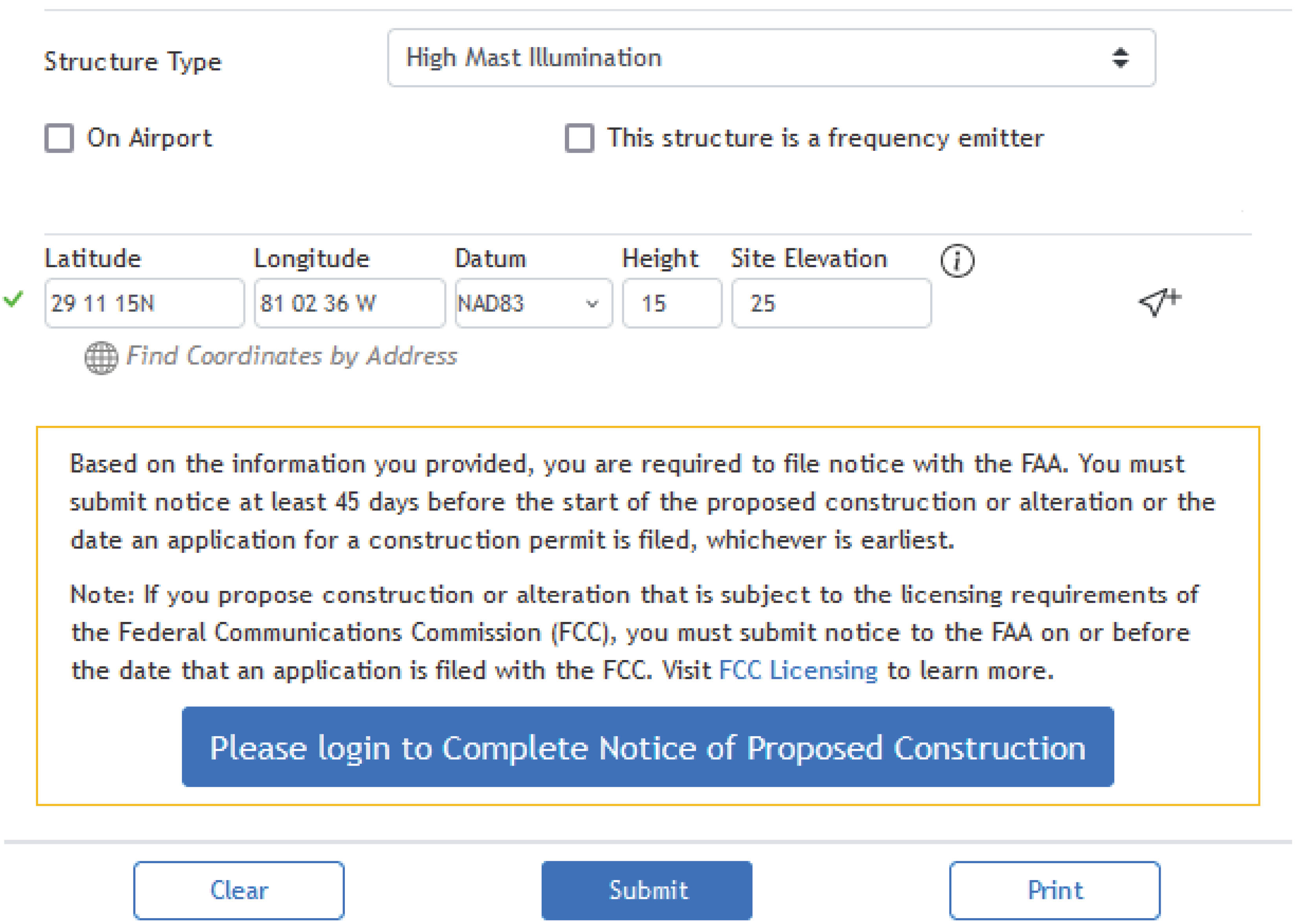
Obstruction analysis can be completed online through the FAAʼs OE/AAA website, https://oeaaa.faa.gov/ (FAA, 2025). The site and process review objects that exceed the Part 77 criteria and that may harm aeronautical activity. To determine the airspace impacts caused by objects in navigable airspace, the website provides a notice criteria tool. The pre-screening tool asks the user to input the following information:
- Structure type
- On or off airport
- If the structure is a frequent emitter
- Latitude, longitude, height, and site elevation.
This pre-screening tool refers to Part 77 imaginary surfaces. It provides one layer to determine whether a structure violates the imaginary surface requirements and whether a notice must be filed with the FAA, as shown in Figure 1.
The prescreening tool will then allow the user to log in to complete the notice and the FAA form 7460-1, Notice of Proposed Construction or Alteration. A filing will be required if a structure (FAA, 2025):
- Is on an airport or heliport per 14 CFR Part 77, Section 77.9.
- Filing has been requested by the FAA.
- Exceeds 200 ft above ground level.
- Is in proximity to an airport and will exceed the slope ratio.
- Involves the construction of a traverse way (i.e., highway, railroad, waterway, and so forth) and is once adjusted.
- Emits frequencies and does not meet the conditions of the FAA Co-location Policy.
- Is in an instrument approach area and might exceed Part 77 Subpart C.
- Will be in proximity to a navigation facility and may impact the assurance of navigation signal reception.
The OE/AAA website offers geographic information systems (GIS) tools. GIS tools for airport obstruction analysis help identify potential obstructions by analyzing spatial data on locations, elevations, and airspace requirements. GIS helps airports visualize airspace and identify potential hazards in a spatial context. GIS can identify obstructions by their location and the extent of their penetration into protected airspace. GIS also can, if appropriate, support mitigation done
Long Description.
The form interface displays fields for submitting a notice of proposed construction to the Federal Aviation Administration (FAA). It includes options for structure type, such as high mast illumination, and checkboxes for on-airport and frequency emitter. Location details include latitude 29 11 15N and longitude 81 02 36 W, with a datum of NAD 83. Height and site elevation fields are set to 15 and 25, respectively. A notice explains the requirement to file at least 45 days before construction. A blue button prompts users to log in to complete the notice, with options to clear, submit, or print the form.
by removing or modifying obstacles and ensuring compliance with regulations. GIS can also streamline analysis through automated capabilities to reduce manual effort and the time required for obstacle analysis, data management, and reporting.
The FAA provides guidelines through AC 150/5300-18B, “General Guidance and Specifications for Submission of Aeronautical Surveys to NGS: Field Data Collection and Geographic Information System (GIS) Standards” (FAA, 2009). The Runway Airspace Management (RAM) Tool is a module within ADIP that manages airport airspace and supports decision-making on obstacle mitigation, capacity planning, and operational safety. Access to airports is available through the Airport Data and Information Portal (ADIP) to manage airport facility data, identify active projects, and connect to the OE/AAA notification tool.
State Regulations
ACRP Research Report 195 (Kireyev et al. 2019a) found that 43 states have some type of legislation addressing obstructions and protecting navigable airspace at the local level, with state airspace protection zoning falling into one of two categories:
- Legislation authorizing local airspace protection zoning
- Legislation requiring local airspace protection zoning
The responsibility for protecting airports from obstructions rests with all levels of government, with the federal, state, and local governments each having different regulatory and enforcement provisions (Figure 2).
For example, in Florida, avigation easements are primarily regulated at the local level, but state laws and FAA standards guide them. Title XXV Aviation, Chapter 333 of the Florida Statutes

Long Description.
The flowchart depicts a hierarchical structure of governance. It starts with the federal level, labeled as advisory and regulatory, followed by the state level, which is regulatory. The final stage is the local level, focused on enforcement.
(“Airport Zoning”) specifically governs how local governments regulate land use around airports. Chapter 333 states that (Florida Statutes, 2023):
(8) The department may not approve a permit for the construction or alteration of an obstruction unless the applicant submits documentation showing both compliance with the federal requirement for notification of proposed construction or alteration and a valid aeronautical study. A permit may not be approved solely on the basis that the Federal Aviation Administration determined that the proposed construction or alteration of an obstruction was not an airport hazard.
And requirements for localities to adopt:
333.03 Requirement to adopt airport zoning regulations.—
(1)(a) Every political subdivision having an airport hazard area within its territorial limits shall adopt, administer, and enforce, under the police power and in the manner and upon the conditions prescribed in this section, airport protection zoning regulations for such airport hazard area.
Local governments in Florida, such as counties and cities, are required to adopt airport protection zoning regulations. These often include securing avigation easements over properties that could interfere with airport operations. When someone builds a structure or makes changes near an airport, they often must grant an avigation easement before receiving approval, primarily if the structure affects protected airspace, such as approach/departure paths. The actual negotiation and recording of the easements occur locally.


