Mechanisms to Address Off-Airport Obstructions (2026)
Chapter: 4 Case Examples

CHAPTER 4
Case Examples
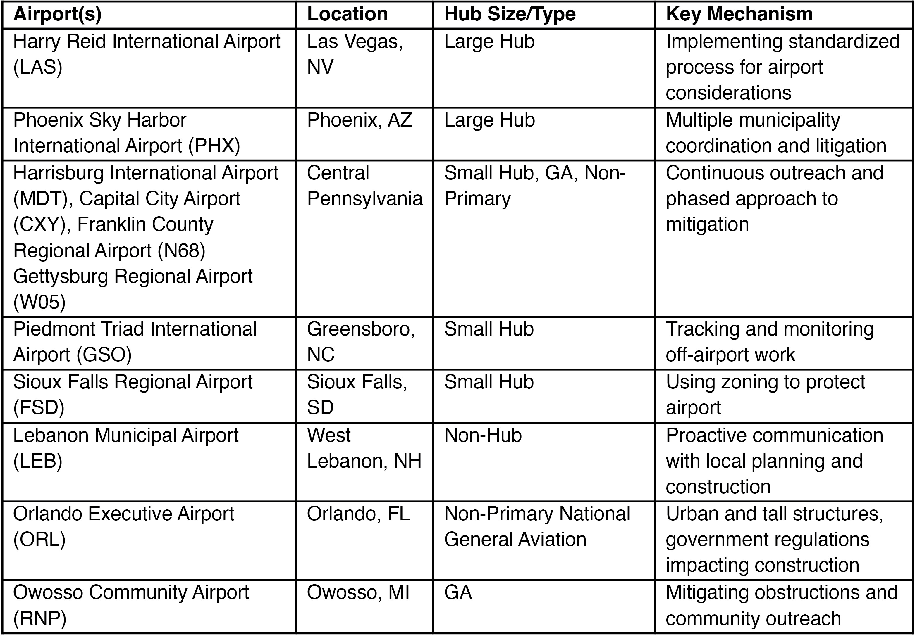
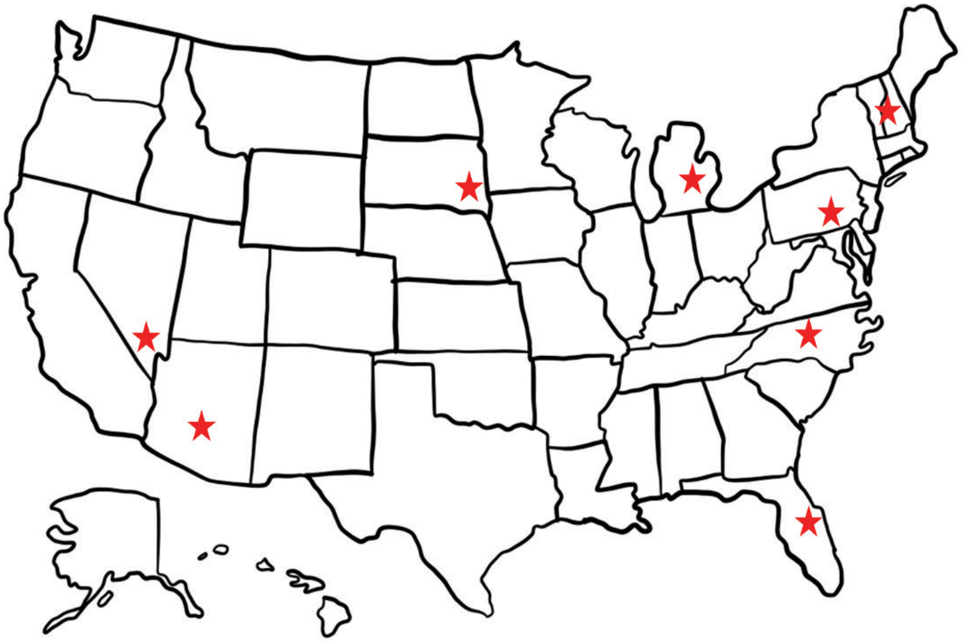
Airport case examples of mechanisms to address off-airport obstructions are detailed to provide context for the methods airports are using to address existing obstructions, surrounding land use, proposed construction, and temporary obstructions such as construction cranes. Table 6 shows case example airports, their hub size, and the key mechanisms they employ for obstructions. The case examples are also in different geographic regions of the country (Figure 18).
Each case example includes background context about the airport and region, with information on the programs acquired through interviews with airport managers, operations personnel, airport stakeholders, and other airport staff involved in monitoring operations both on and off the airport.
Long Description.
The column headers of the table are airport or airports, location, hub size or type, and key mechanism. The data given in the table row-wise are as follows: Row 1: Harry Reid International Airport (LAS): Las Vegas, NV; large hub; implementing standardized process for airport considerations. Row 2: Phoenix Sky Harbor International Airport (PHX): Phoenix, AZ; large hub; multiple municipality coordination and litigation. Row 3: Harrisburg International Airport (MDT), capital city airport (CXY), Franklin County Regional Airport (N68), Gettysburg Regional Airport (W05): Central Pennsylvania; small hub, GA, non-primary; continuous outreach and phased approach to mitigation. Row 4: Piedmont Triad International Airport (GSO): Greensboro, NC; small hub; tracking and monitoring off-airport work. Row 5: Sioux Falls Regional Airport (FSD): Sioux Falls, SD; small hub; using zoning to protect airport. Row 6: Lebanon municipal airport (LEB): West Lebanon, NH; non-hub; proactive communication with local planning and construction. Row 7: Orlando Executive Airport (ORL): Orlando, FL; non-primary national general aviation; urban and tall structures, government regulations impacting construction. Row 8: Owosso Community Airport (RNP): Owosso, MI; GA; mitigating obstructions and community outreach.
Long Description.
The map of the United States outlines eight states with red stars indicating key locations. Stars are placed in the northeast, southeast, central, and western regions.
Harry Reid International Airport (LAS), Las Vegas, Nevada
Large Hub Primary Airport
Case Example: Implementing Standardized Process for Airport Considerations
Las Vegas, Nevada, a vacation destination, has seen impressive growth over the years, with its population now exceeding 650,000. The city has a diverse economy powered by tourism, gaming, and increasing investments in technology and healthcare. Harry Reid International Airport (LAS), a Large Hub Primary airport, supports the regionʼs tourism and economic growth through significant passenger traffic (Table 7) and air transport services.
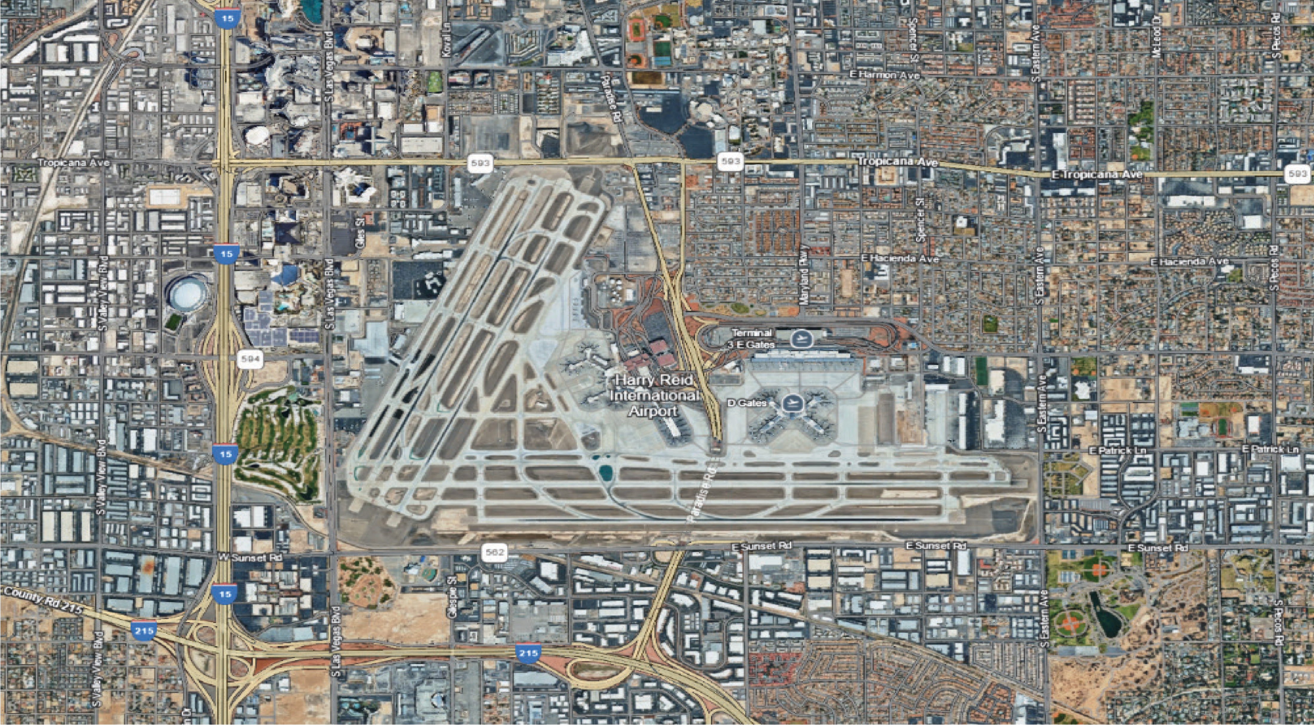
The airportʼs location in a densely populated area with numerous tall structures has posed challenges for airport design and expansion (Figure 19 highlights the proximity of LAS to Las Vegas).

Long Description.
The column headers of the table are year and total operations. The data given in the table row-wise are as follows: Row 1: 2020; 323,422. Row 2: 2021; 487,604. Row 3: 2022; 581,116. Row 4: 2023; 611,806. Row 5: 2024; 612,457. Source: FAA operations and performance data, https colon slash slash a spm dot faa dot gov / opsnet slash sys slash airport dot asp.
Long Description.
The photo highlights the airportʼs extensive network of runways and taxiways. The central terminal area is visible, surrounded by various airport facilities. It also shows the dense urban landscape around the airport, with a grid of roads and numerous buildings. Major highways intersect near the airport, showing its connectivity to the city. The layout of the airport and its integration into the urban environment are clearly shown.
The need to accommodate both air traffic and the surrounding urban development requires careful planning and adherence to regulations. The Las Vegas Strip is known for its high concentration of tall buildings, including hotels and casinos, which can create obstacles for aircraft approaching or departing the airport. As shown in the McCarran International Airport v. Sisolak text box, the airport has been involved in height restrictions imposed on private land.
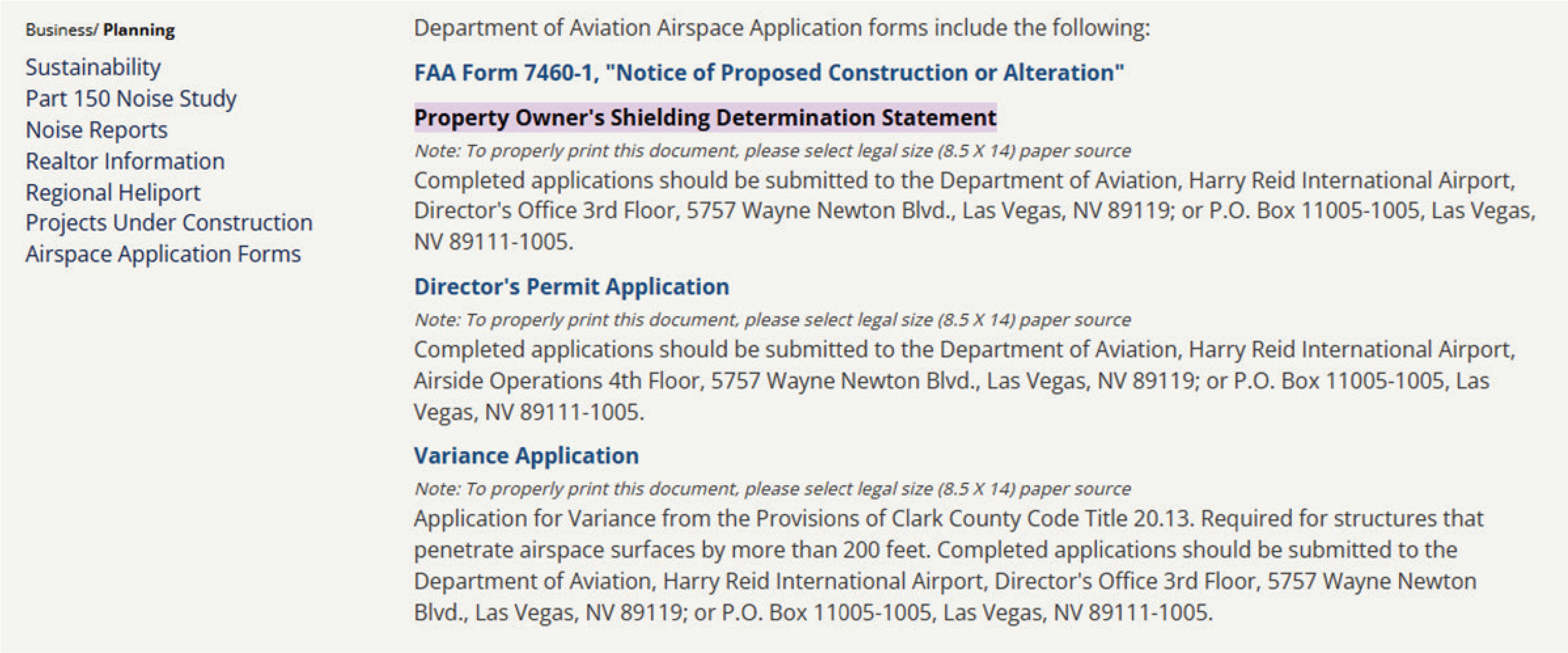
The airport has developed a guide outlining its obstruction evaluation process, which is available on the airportʼs website (Figure 20). This document walks through the key steps to evaluate proposed structures near the airport, ensuring that proposed projects meet both FAA and Clark County requirements. The process covers how to determine if FAA Form 7460 is necessary, how to guide proponents on required permits, and how to review submitted plans and assess potential impacts on safety, airspace capacity, and airport throughput. Additionally, Clark County Code Titles 20 and 30 govern local zoning and land use regulations, which are considered when reviewing applications.
Appendix D contains the LAS Directorʼs Permit Application and Property Ownerʼs Shielding Determination Statement. The steps provided in the process include:
- Step 1: Check if FAA Form 7460-1 is Required
Use the FAA Notice Criteria Tool to determine whether the structure requires FAA notification:- FAA Notice Criteria Tool (web link)
- Step 2: Instruct the Proponent on Local Permits
If an FAA filing is required, inform the proponent about the following permits:
Long Description.
A list of Department of Aviation Airspace application forms. It includes FAA Form 7460 dash 1 for ‘Notice of Proposed Construction or Alterationʼ, ‘Property Ownerʼs Shielding Determination Statementʼ, ‘Directorʼs Permit Applicationʼ, and ‘Variance Applicationʼ. Each form has specific submission instructions, such as submitting to the Department of Aviation at Harry Reid International Airport, with addresses provided for both physical and PO. Box submissions. The note advises selecting legal-size paper for printing.
- Directorʼs Permit
- Download Directorʼs Permit Application (PDF) (web link)
- Shielding Permit (if applicable)
- Shielding Determination Information (web link)
- Step 3: Review Submitted Plans
- When plans are submitted, confirm they match the FAA 7460 filing details:
- Height
- Coordinates/location
- Structure type and dimensions
- Request corrections if any discrepancies are found.
- Step 4: Evaluate for Airspace Impact
- Run internal checks to assess if the proposed structure would:
- Pose a safety risk.
- Reduce airspace capacity.
- Affect airport throughput.
Phoenix Sky Harbor International Airport (PHX), Phoenix, Arizona
Large Hub Primary Airport
Case Example: Multiple Municipality Coordination and Litigation
Phoenix, Arizona, has experienced population growth over the past few decades. As of the latest census, the city has a population of over 1.7 million, making it the fifth-largest city in the nation. Phoenix Sky Harbor International Airport (PHX) is an integral part of the cityʼs growth. It is one of the busiest airports in the United States, with nearly half a million operations annually (Table 8).
PHX is owned and operated by the city of Phoenix, so projects within the city can be coordinated with airport staff. The location of PHX borders both the municipalities of Phoenix to the west and Tempe to the east (Figure 21). Both the city of Phoenix and the city of Tempe have codified the
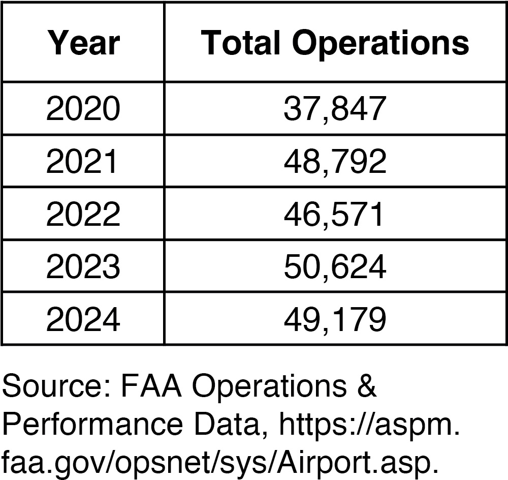
Long Description.
The column headers of the table are year and total operations. The data given in the table row-wise are as follows: Row 1: 2020; 37,847. Row 2: 2021: 48,792. Row 3: 2022; 46.571. Row 4: 2023; 50,624. Row 5; 2024; 49,179. Source: FAA operations and performance data, https colon slash slash aspm dot faa dot gov slash opsnet slash sys slash airport dot asp

Long Description.
The airport is centrally located between the cities of Phoenix and Tempe. Major highways such as Interstate 10 and State Route 202 are visible, along with key streets like E Van Buren Street and E Broadway Road. It highlights the airportʼs runways and terminals, surrounded by urban infrastructure. Nearby areas include E Roosevelt Street and E Jefferson Street, with the cities of Phoenix to the west and Tempe to the east clearly marked.
FAA Form 7460 process requirements in their zoning regulations, ensuring the OE/AAA process is followed.
In 2022, the city of Tempe proposed redeveloping a site approximately 2 miles from PHX with a variety of buildings, including residential apartment towers, entertainment uses, and a professional hockey arena. The proposed development would have added thousands of residents to the airportʼs 65 dBA Day-Night Average Sound Level contour, and several buildings would have resulted in both temporary and permanent airspace obstructions, particularly one-engine inoperative (OEI) procedures. The proposal was reminiscent of a planned development 20 years earlier in the same general area that would have included a professional football stadium with similar airspace-obstruction issues. Ultimately, the proposed development was rejected by Tempe voters in 2023. Additionally, PHX, through litigation and a negotiated settlement agreement, worked with Tempe to ensure that any future development in the area would comply with Part 77, FAA Form 7460, and noise compatibility standards, while granting PHX an avigation easement that would also ensure OEI procedure surfaces would be maintained.
For a Large Hub airport in a growing community, having the requirements of FAA Form 7460 codified in zoning ensures developers must meet minimum airport operational safety requirements to secure project approval, regardless of the zoning authorityʼs jurisdiction relative to the airport. Additionally, in Arizona, state law requires cities to notify bordering cities of proposed rezonings, ensuring airport personnel can analyze proposed projects in detail and request mitigation before approval. This process is particularly useful for proposed off-airport development with unique issues, such as mixed-use sports entertainment projects, where the FAA Form 7460 process may not provide analysis for OEI penetrations, special events such as laser-lighting shows and drone use, or impacts on building material reflectivity.
Central Pennsylvania Airports (MDT, CXY, N68, W05)
Case Example: Continuous Outreach and Phased Approach to Mitigation
- Harrisburg International Airport (MDT), Harrisburg, Pennsylvania (Small Hub Primary Airport)
- Capital City Airport (CXY), Fairview Township, Pennsylvania (Non-Primary Regional Airport)
- Franklin County Regional Airport (N68), Franklin County, Pennsylvania (General Aviation Airport, Local)
- Gettysburg Regional Airport (W05), Cumberland Township, Pennsylvania (General Aviation Airport, Local)
In central Pennsylvania, four publicly owned airports are overseen by the Susquehanna Area Regional Airport Authority. Figure 22 shows the geographic locations of the airports. Harrisburg International Airport (MDT), located in Harrisburg, is classified as a Small Hub Primary airport (Table 9). MDT is a towered airfield with one 10,000-foot runway.
Capital City Executive Airport (CXY) (Table 10) in Fairview Township is a Non-Primary Regional airport. It identified an issue due to obstructions, given its location next to the Susquehanna River and terrain that rises around the airport, as shown in the topography map in Figure 23. CXY has two runways, one at 5,000 feet and the other at 3,778 feet.
The other two airports are general aviation: Franklin County Regional Airport (N68), with a 3,300-foot paved runway, and Gettysburg Regional Airport (W05), with a 3,100-foot paved runway. In dealing with obstructions, the Susquehanna Area Regional Airport Authority must work with a variety of airports, address funding issues, address public opposition to tree removal, and provide ongoing education for those wanting to develop around these airports.

Long Description.
The satellite map displays several airports in Pennsylvania, including N68 Airport near Chambersburg, W05 Airport near Gettysburg, CXY Airport, and MDT Airport near Mechanicsburg. Major highways like I-76 and I-81 are visible, along with the Tuscarora State Forest.

Long Description.
The column headers of the table are year and total operations. Row 1: 2020; 37,847. Row 2: 2021; 48,792. Row 3: 2022; 46,571. Row 4: 2023; 50,624. Row 5: 2024; 49,179. Source: FAA operations and performance data, https colon slash slash aspm dot faa dot gov slash opsnet slash sys slash airport dot asp

Long Description.
The column headers of the table are year and total operations. The data given in the table row-wise are as follows: Row 1: 2020; 24,229. Row 2: 2021; 31,221. Row 3: 2022; 25,842. Row 4: 2023; 28,371. Row 5: 2024; 29,791. Source: FAA operations and performance data, https colon slash slash aspm dot faa dot gov slash opsnet slash sys slash Airport dot asp
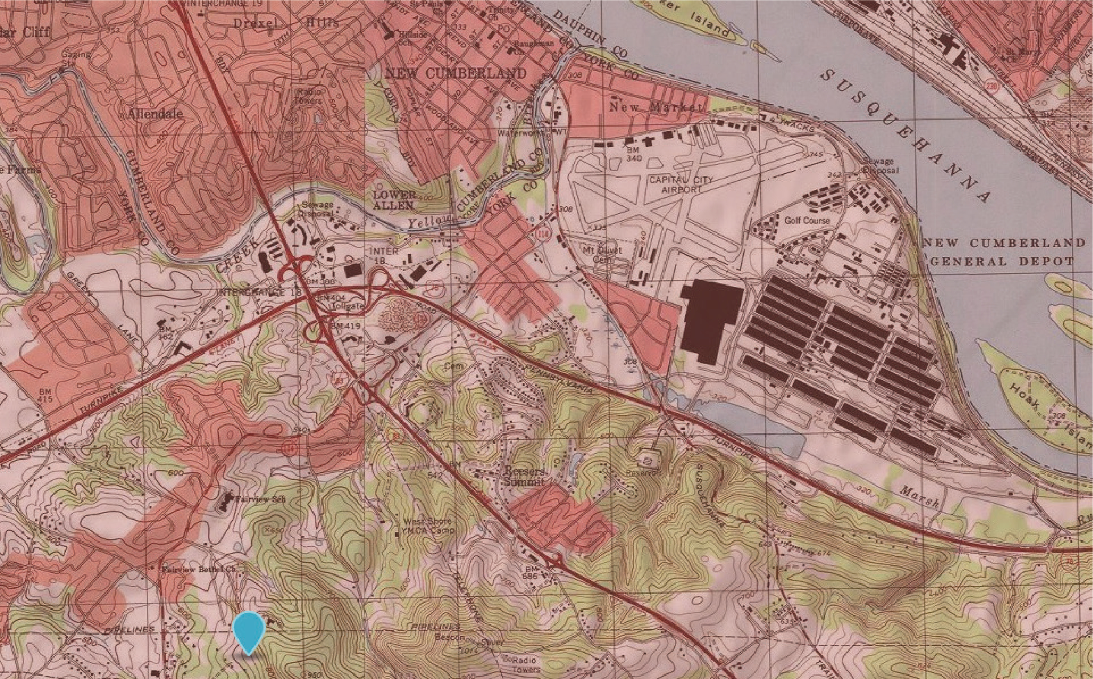
Long Description.
The map shows the New Cumberland area, highlighting roads, elevation contours, and the Susquehanna River. Notable features include the capital city airport and New Cumberland General Depot. The map shows detailed terrain with contour lines indicating elevation changes and various infrastructures. The Susquehanna River runs along the right side, with the depot and airport situated nearby.
Obstructions for these airports have been identified as a prolonged and challenging issue that the Airport Authority addresses in collaboration with the airports, surrounding municipalities, and the Pennsylvania Department of Transportation. The state issued grants to develop the overlay districts as part of the zoning ordinances following Part 77 and, in some areas, Standard Terminal Instrument Procedures guidelines, and to ensure that future projects adhere to standards designed to prevent interference with airspace. The Aviation Authority has been meeting with local planning staff and leadership in the townships around the airports, enabling them to effectively manage obstruction issues in conjunction with state inspections.
The latest airport review led to a multi-phase project to remove trees, vegetation, and other obstructions. Over the course of 4 years, with approximately $1 million per year, the Authority has addressed obstructions around each airport. The work started with the obstructions closest to the airport and runway ends in the first phase, then extended out from the airfields until all obstructions were addressed and mitigated.
The Authority approached each phase differently, based on lessons learned from previous experiences and public reactions. Phase 1 was characterized as:
- Being proactive
- Airport as good neighbor to landowners
- Open and transparent in reasons behind tree removals
- Many options are available to residents for replacement of trees
- Working best to appease landowners through stump grinding and property restoration
The next year, in Phase 2, the Authority modified its approach due to public concern about the removal and trimming process. The new process changed by:
- Limiting the types of tree replacements for residents
- Sending notices electronically in more of an automated procedure
Then in the third year, the Authority:
- Provided no options for tree replacement initially to residents. After work was completed, they came back with some options if the residents wanted.
- Used door hangers with general information on when the personnel would be on their property.
- Used public meetings, but had light attendance at events with mixed support/unsupportive attitude toward removing trees.
- Met with property owners and showed them the language of the deeds that stated it was the residentʼs responsibility to maintain the trees, and that the airport was going above and beyond.
The staff indicated this third method was the preferred process and perceived as the best way to approach this task, which allowed the airport to remind owners that deeds require them to maintain height limits and that the airport is there to assist homeowners with this task.
Piedmont Triad International Airport (GSO), Greensboro, North Carolina
Small Hub Primary Airport
Case Example: Tracking and Monitoring Off-Airport Work
Greensboro, North Carolina, is home to Piedmont Triad International Airport (GSO) (Figure 24). Classified as a Small Hub Primary airport with yearly operations shown in Table 11, GSO provides connectivity for residents and businesses alike, facilitating travel and trade across numerous destinations.
The airport personnel indicated that the obstruction process accounted for a large percentage of time compared to other tasks, leading to the implementation of a process to assist the airportʼs
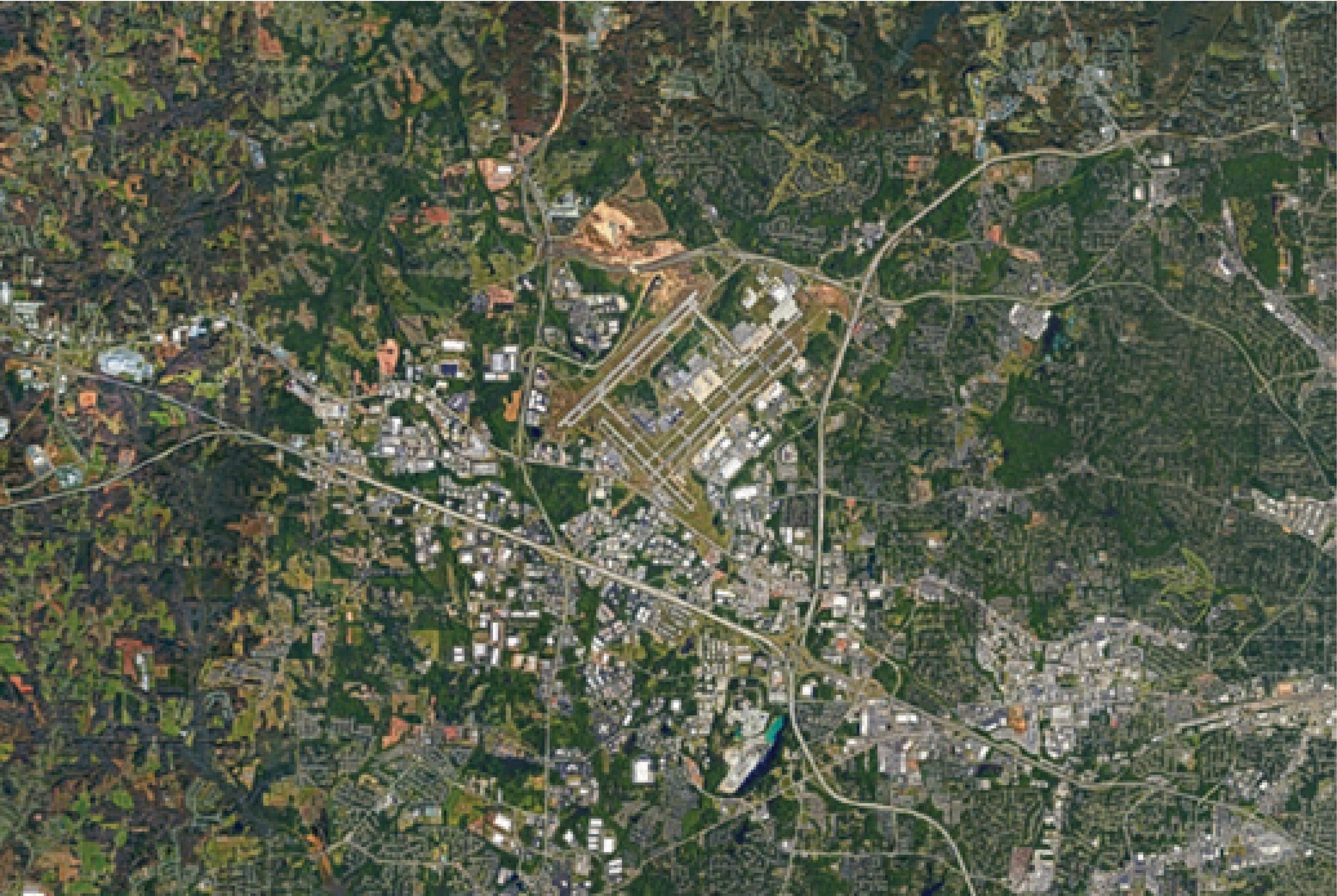
Long Description.
The cityscape with a detailed view of urban infrastructure. Roads form a network connecting various districts, with a prominent highway cutting through the center. Numerous buildings are clustered in different areas. Green spaces are interspersed throughout, providing contrast to the urban environment.

Long Description.
The column headers of the table are year and total operations. The data given in the table row-wise are as follows: Row 1: 2020; 69,440. Row 2: 2021; 87,257. Row 3: 2022; 91,088. Row 4: 2023; 105,115. Row 5: 2024; 93,157. Source: FAA operations and performance data, https colon slash slash aspm dot faa dot gov slash opsnet slash sys slash Airport dot a s p
Operations Department. The airport staff uses a variety of methods for off-airport obstruction identification:
- Through email subscription with OE/AAA that notifies of new or changed cases in the local area. Airport staff then uses a system that shows on a map where a crane or temporary structure will be for the duration of the FAA Form 7460 approvals, along with information such as whether Notices to Airmen or notices to the airport are required. In those cases, the map depiction will also change colors during the hours the crane is in operation.
- Some of the crane companies will call the airport directly if there is to be work near the airport. The companies are often unsure of the regulations regarding cranes/temporary structures, so they notify the airport out of caution.
- It is not uncommon for operations officers to spot an unplanned crane. At that point, the staff will try to make contact and inform the operator of OE/AAA regulations.
As a Small Hub airport, GSO has limited staffing resources, and identifying obstructions, checking the OE/AAA, and conducting other visual checks of surrounding construction require considerable staff time. The staff also takes time to show both on-airport and off-airport contractors how to navigate the OE/AAA website. They also develop relationships with outside contractors to mitigate the problems. GSO has noted that some companies have some level of training on OE/AAA, though most seem to encounter confusion at points. The airport has identified that additional support from the state DOT would be a helpful resource.
Sioux Falls Regional Airport (FSD), Sioux Falls, South Dakota
Small Hub Primary Airport
Case Example: Using Zoning to Protect Airport
Sioux Falls, South Dakota, is home to Sioux Falls Regional Airport (FSD), a Small Hub Primary airport. The city has steadily grown over the years, and FSD plays a role in this development by facilitating vital air transport services that connect the city to various destinations, with yearly operations as shown in Table 12.
The city surrounds FSD, and two counties are located around the airport as well (Figure 25). The airport has developed relationships over many years with Sioux Falls and both counties to consider developments that would not impact the airport. The process includes the use of an Airport Overlay District, which provides mapping of the area and land use criteria. Airport staff can review projects using the Airport Overlay District to determine whether to object or not object to the project. The Overlay District Building Application, shown in Figure 26, begins the process by allowing the airport to work with developers not only on obstructions through the FAA Form 7460 process via OE/AAA but also on compatible land use.
Communication with the airport is supported by the cityʼs zoning regulations, which help existing developers become familiar with the process and the importance of complying with obstruction requirements. The communication process is informal since there is no guiding document enforceable by regulation. Sioux Falls can review zoning regulations on its own to make an obstruction determination; however, it is noted that it is not versed in Part 77 or other airfield protections. Coordination is a matter of one-to-one outreach between FSD and city officials, and efforts have paid off as new officials are made aware of the coordination effort with their on-the-job training. Additionally, as part of a recently completed compatible land use study, the airport held multiple meetings with local land use/zoning officials to highlight and educate them on the necessity of airfield protection.

Long Description.
The column headers of the table are year and total operations. The data given in the table row-wise are as follows: Row 1: 2020; 57,536. Row 2: 2021; 69,410. Row 3: 2022; 69,691. Row 4: 2023; 70,922. Row 5: 2024; 72,144. Source: FAA operations and performance data, https colon slash slash aspm dot faa dot gov slash opsnet slash sys slash Airport dot asp
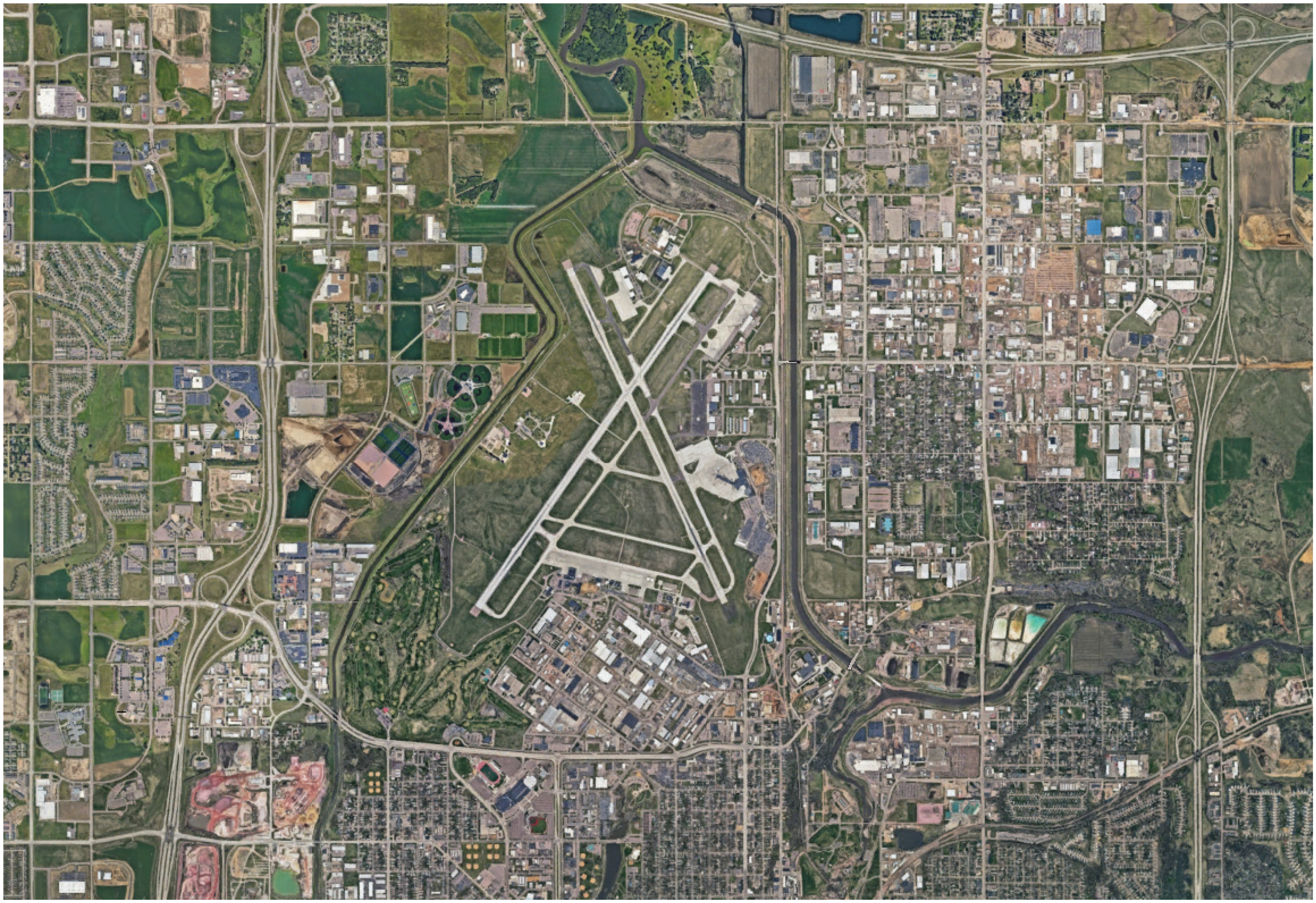
Long Description.
The view displays an airport with intersecting runways forming an X shape, surrounded by urban development and green spaces. Roads and buildings are visible. The layout includes a network of highways and smaller roads, with various structures and open fields surrounding the airport complex.
The importance of obstruction processes and land-use protection at the airport was highlighted when, years ago, Sioux Falls developed a water treatment plant across the street from the airport along the crosswind runway (Figure 27). A water tower at the location required, at a minimum, adjustment of the flight path on the predominant wind runway. This construction demonstrated how land use controls can mitigate significant impacts.
Lebanon Municipal Airport (LEB), West Lebanon, New Hampshire
Non-Hub Primary Airport
Case Example: Proactive Communication with Local Planning and Construction
West Lebanon, situated in the Upper Valley region of New Hampshire, has rolling hills and expansive forests, and Lebanon Municipal Airport (LEB) serves as a Non-Hub Primary Airport (Figure 28).
The airport engages proactively with local planning and construction authorities, demonstrating its commitment to community growth and engagement. The city of Lebanon created a Zoning Ordinance based on Part 77 to limit the height of buildings and other objects around the airport. Land use on airport property and adjacent to the airport is zoned as light industrial. By fostering collaboration, LEB ensures that its airport operations and expansions are well coordinated, minimizing disruptions and maximizing benefits for the surrounding region.
Lebanon Municipal Airport and the city of Lebanon have a close relationship regarding ongoing construction projects in the area that could impact airport operations. The airport

Long Description.
The application form is titled ‘Sioux Falls Regional Airport Overlay District Building Application.ʼ It begins with an introduction. It includes sections for property owner information, project details like primary site elevation, maximum height, and total height, and application details such as city and county permits. The owner agentʼs details are also asked. There are fields for project description, property location with latitude and longitude, and construction type options that are new, alteration, permanent, temporary, building, tower, equipment, or crane. Lighting details and submittal requirements are also included. The form ends with an attestation section for the owner or agentʼs signature and date, along with airport use and review sections for compliance and impacts.
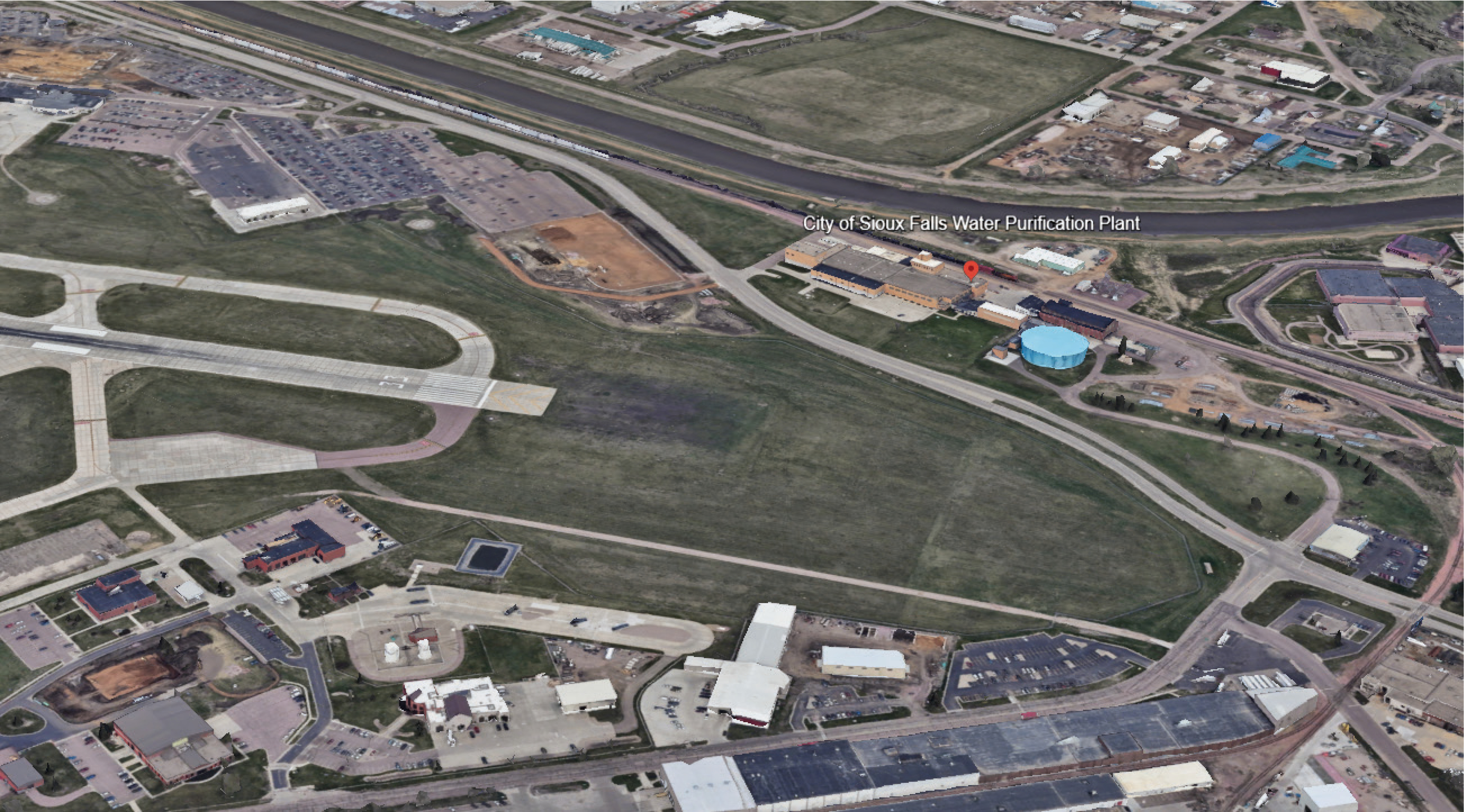
Long Description.
The water treatment plant is located near a network of roads and various buildings. The plant is identifiable by its large structures and adjacent open spaces. Surrounding the plant are several buildings, parking lots, and green areas. The layout of the roads and the positioning of the plant within the urban landscape are clearly visible.
has also developed relationships with the City Planning and Development Department, as any project involving construction or alteration must notify the airport, regardless of its height. The City Planning and Development Department has a series of short questions to determine the impact on the airport and whether the airport manager needs to be involved. Those questions and the flow are in Appendix E.
The terrain surrounding the airport poses a challenge. A proposed housing development would include housing that encroaches on certain surfaces. The ridgeline they are building on is outside the approach but still within the airportʼs 20,000-foot radius. As part of the obstruction review process, the airport manager reviewed the project and utilized an internally developed spreadsheet (Figure 29) to determine whether FAA Form 7460 would be required. Additionally, projects near the airport involve installing solar cells on building roofs, increasing their height, and potentially impeding certain surfaces.
Maintaining close relationships with surrounding businesses through the city offices has successfully preempted potential building intrusions. For example, one local manufacturing company designed a building with a tiered roof to mitigate obstructions and comply with the 7:1 transitional surface requirement. The business is in the adjacent business park and has been coordinating with the airport regarding its expansion plans. Meetings with the airport began during the companyʼs preliminary design stage and, during construction, they were prompt in coordinating with the control tower and airport on cranes and construction equipment. In the absence of state regulations, the airport shared that having city regulations and buy-in and close coordination with the city improved the process and ensured the airport operates without any obstruction-related changes to approach surfaces or other modifications.
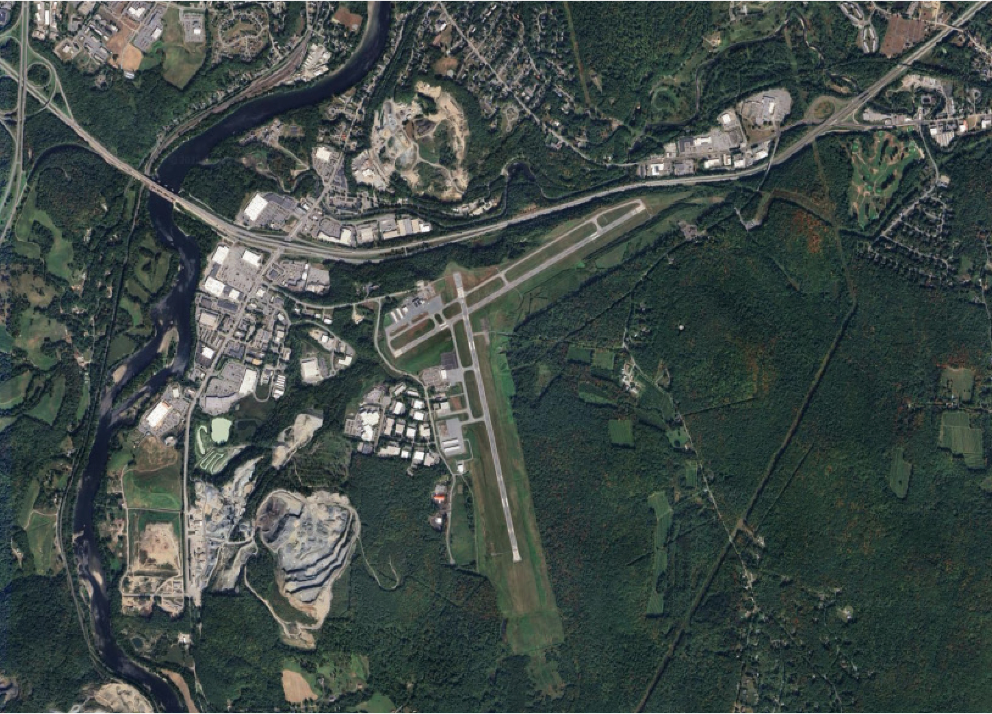
Long Description.
The airport shows multiple runways and taxiways, surrounded by a mix of urban and forested landscapes. Buildings and infrastructure are visible near the airport, with roads connecting the area to the surrounding city. It shows a river flowing through the top left.
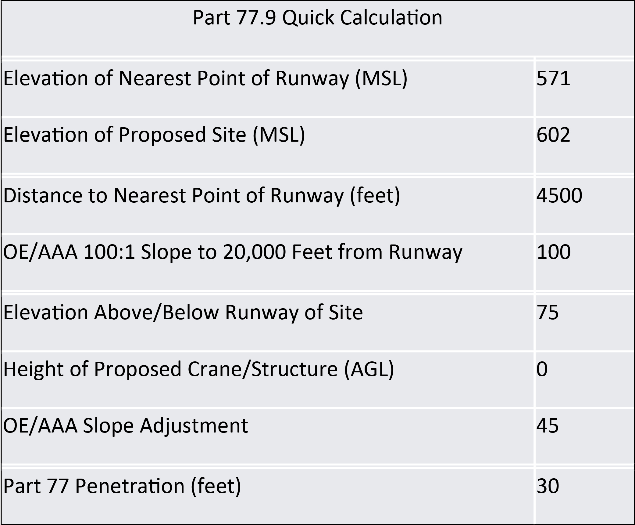
Long Description.
The table details the elevation of the nearest point of the runway at 571 feet (MSL) and the proposed site at 602 feet (MSL). It includes the distance to the nearest point of the runway as 4500 feet and a 100 to 1 slope to 20,000 feet from the runway at 100 feet. The elevation above or below the runway of the site is 75 feet, with a height of the proposed crane or structure at 0 feet (AGL). An OE slash AAA slope adjustment is noted at 45 feet, and Part 77 penetration is 30 feet.
Orlando Executive Airport (ORL), Orlando, Florida
Non-Primary National General Aviation Airport
Case Example: Urban and Tall Structures, Government Regulations Impacting Construction
Orlando, Florida, known for its world-class theme parks and tourism industry, has seen substantial regional growth over the past few decades with a growing economic base and population that has resulted in the growth of aviation operations in the metropolitan area. Orlando Executive Airport (ORL) serves the city as a gateway for general aviation and business travelers with steady increases in operations over the past 3 years (Table 13). Located just 3 miles from downtown Orlando, ORL features two runways (Figure 30) with surrounding development bordering all sides of the airport.
ORL relies on several processes, procedures, and tools to monitor obstructions off airport property, including new construction, cranes, building maintenance, and vegetation growth. The airport has a close relationship with the city of Orlando Planning and Construction Department, which allows airport personnel to be included as projects are proposed. Additionally, the state of Florida has regulations (Florida Statutes, 2023) that protect navigable airspace and ensure safe airport operations. The proximity of the airport to downtown and the cityʼs size lead to frequent construction projects in the area that could impact the airfieldʼs approach surfaces. The airport operations team also conducts surveillance, identifies potential obstructions, and provides outreach to landowners or construction companies.

Long Description.
The column headers of the table are year and total operations. The data given in the table row-wise are as follows: Row 1: 2020; 122,839. Row 2: 2021; 143,840. Row 3: 2022; 152,282. Row 4: 2023; 174,314. Row 5: 2024; 180,221. Source: FAA operations and performance data, https colon slash slash aspm dot faa dot gov slash opsnet slash sys slash Airport dot asp
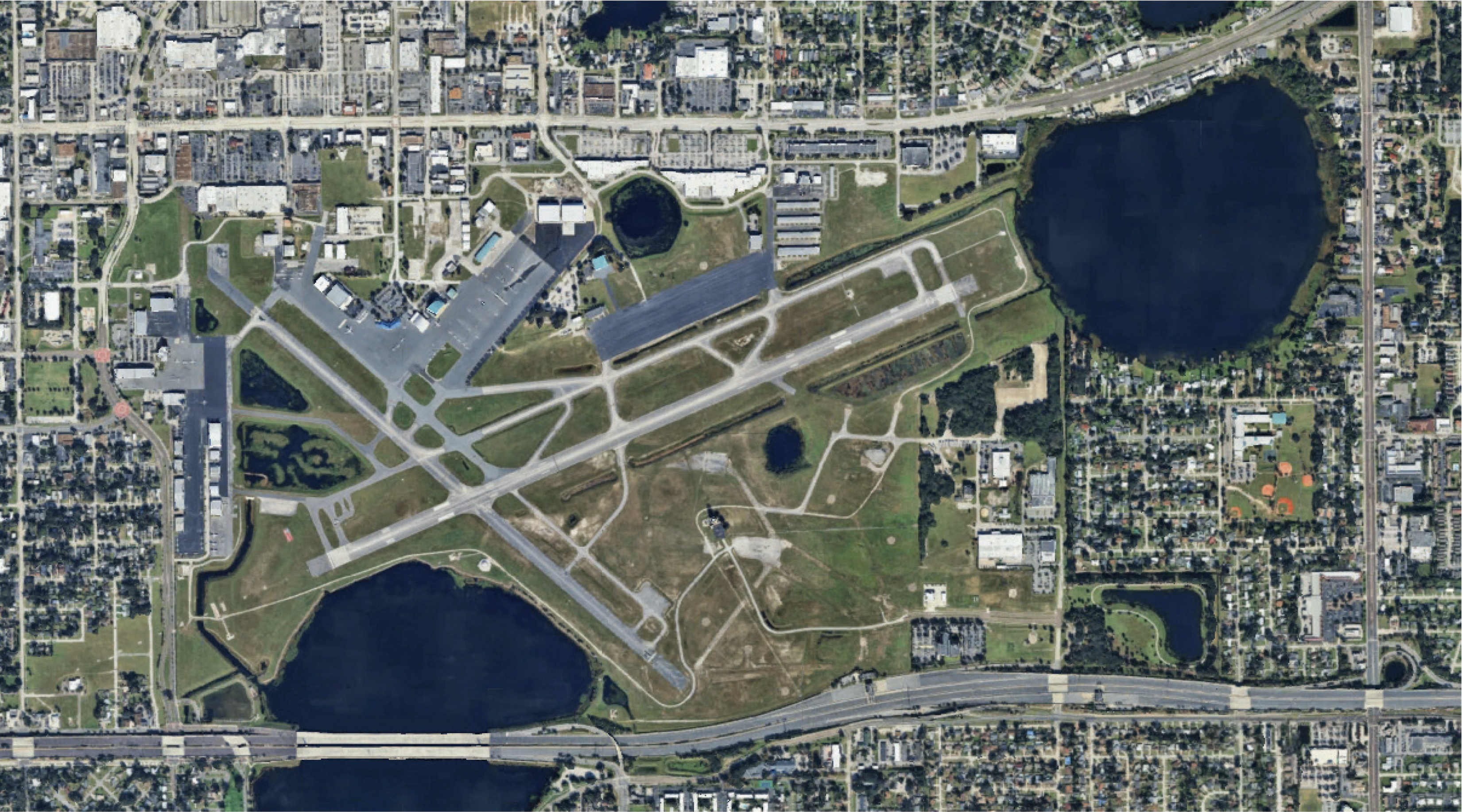
Long Description.
The airport shows multiple runways and taxiways, surrounded by urban infrastructure. The layout includes intersecting runways and adjacent buildings, with several lakes nearby. Roads and residential areas border the airport, indicating its integration within a cityscape.
ORL is also unique because of its proximity to the cityʼs primary commercial airport, Orlando International Airport (MCO) (Figure 31). ORL is about 8 miles north and in line with the MCO north approach of the parallel runways. To the west of ORL lies downtown Orlando, which raises land use concerns.
New construction projects, such as tall downtown buildings, are captured early in the cityʼs planning and review process. The use of cranes for maintenance was mentioned as an item that the ORL operations team is continually seeking. In larger buildings, it is not uncommon to use cranes for maintenance, such as replacing roof-mounted air conditioning units. The quick turnaround to replace this sort of equipment and the short-term nature of the activities often mean the cranes appear without prior notification to the airport for adequate airspace analysis.
ORL must also work within state regulatory requirements, such as the Live Local Act. Live Local Act encourages the development of affordable housing in the state by administratively approving multi-family and mixed-use development if the property is zoned for commercial, industrial, or mixed use. It does not require rezoning, conditional use approval, a variance,

Long Description.
The satellite map displays an urban area with labeled locations: Downtown, OR, and MC. Two paths are marked, one measuring 2.8 miles between Downtown and OR, and another measuring 7.9 miles from OR to MC. The map includes various geographical features like roads and bodies of water.
or a comprehensive plan amendment for the building height, zoning, or density, as described in the act. Cities may not restrict the height of an affordable residential rental multi-family or mixed-use development below the highest allowed height for a commercial or residential development located in the city within 1 mile of the proposed development, or three stories, whichever is higher (Florida Statutes, 2023).
The bill includes restrictions on airports, as detailed here, but airport personnel remain vigilant regarding state regulations that affect airspace.
333.03 Requirement to adopt airport zoning regulations.—
(5) Sections 125.01055(7) and 166.04151(7) do not apply to any of the following:
(a) A proposed development near a runway within one-quarter of a mile laterally from the runway edge and within an area that is the width of one-quarter of a mile extending at right angles from the end of the runway for a distance of 10,000 feet of any existing airport runway or planned airport runway identified in the local governmentʼs airport master plan.
(b) A proposed development within any airport noise zone identified in the federal land use compatibility table or in a land-use zoning or airport noise regulation adopted by the local government.
(c) A proposed development that exceeds maximum height restrictions identified in the political subdivisionʼs airport zoning regulation adopted pursuant to this section.
ORL is also inspected annually by the Florida Department of Transportation (FDOT), as required by Florida Statutes, to ensure it meets safety standards and to identify obstructions. ORL outreach teams are used to contact landowners, and this has worked without requiring any other legal or enforcement methods. The airport will also replace trees removed from private property with smaller, flowering trees that do not reach mature heights.
The airport has regular outreach with surrounding neighborhoods, approximately five meetings per year. The meetings include all the surrounding neighborhoods and are not about obstructions. However, the outreach efforts build bonds with the neighbors and could be a positive factor if vegetation growth becomes an issue and the airport has to approach the landowners.
Owosso Community Airport (RNP), Owosso, Michigan
General Aviation Airport
Case Example: Mitigating Obstructions and Community Outreach
The Owosso Community Airport (RNP), in Shiawassee County, Michigan, is used for general aviation. RNP has an airport board composed of members of the city of Owasso, Caledonia Township, and Shiawassee County, which supports the airport as a vital component of the region. The airport used easements over 30 years old, bought new easements, leveraged state data, and may pursue legal action to address obstructions outside the airport boundary.
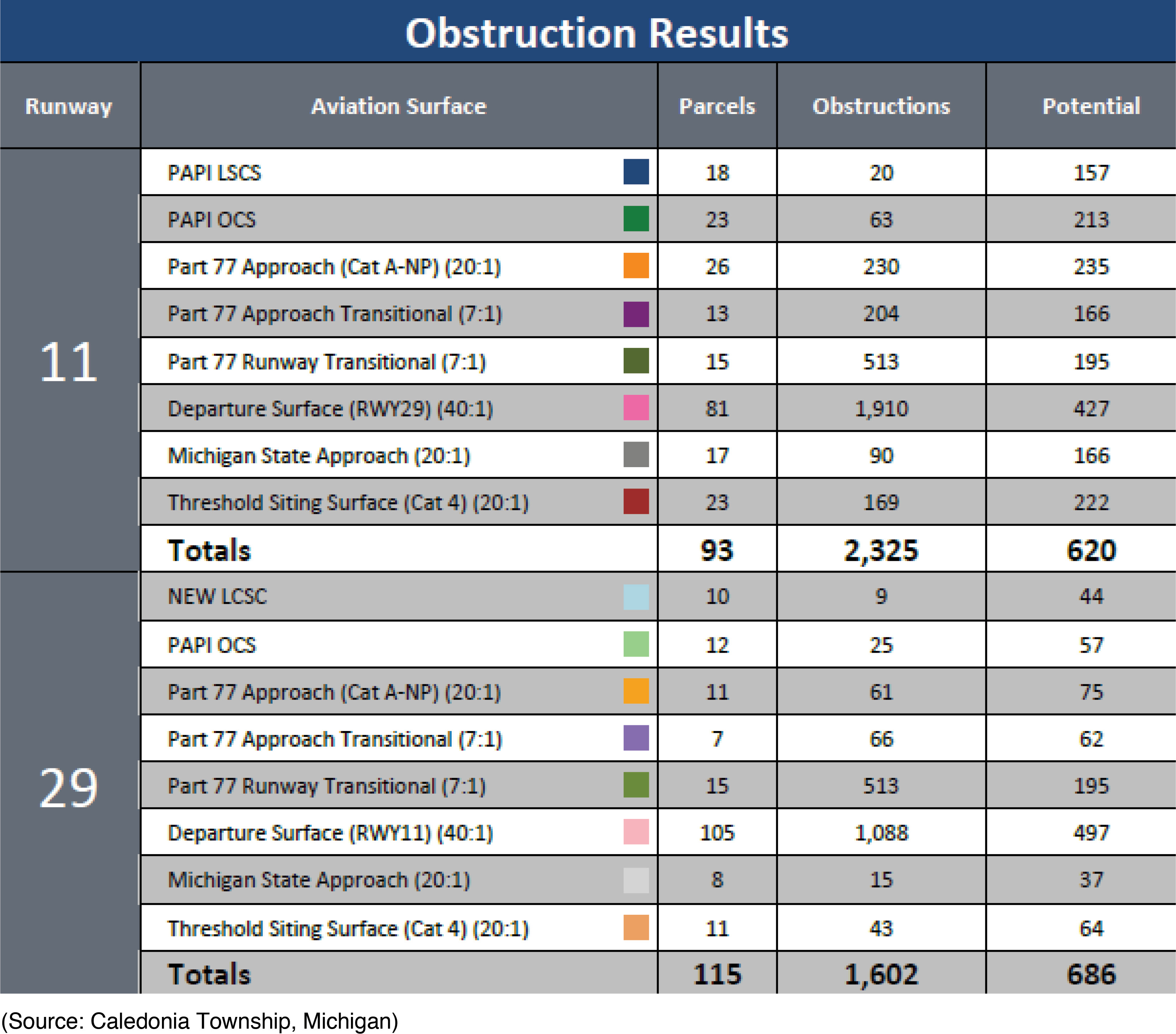
In 2021, Owosso Community Airport had a lidar study conducted as part of a navigational aid replacement study, which showed nearly 4,000 obstructions surrounding the airport (Table 14) and led to a provisional license, meaning the airport has not met all the requirements for obstruction removal identified by the Michigan Department of Transportation Office of Aviation.
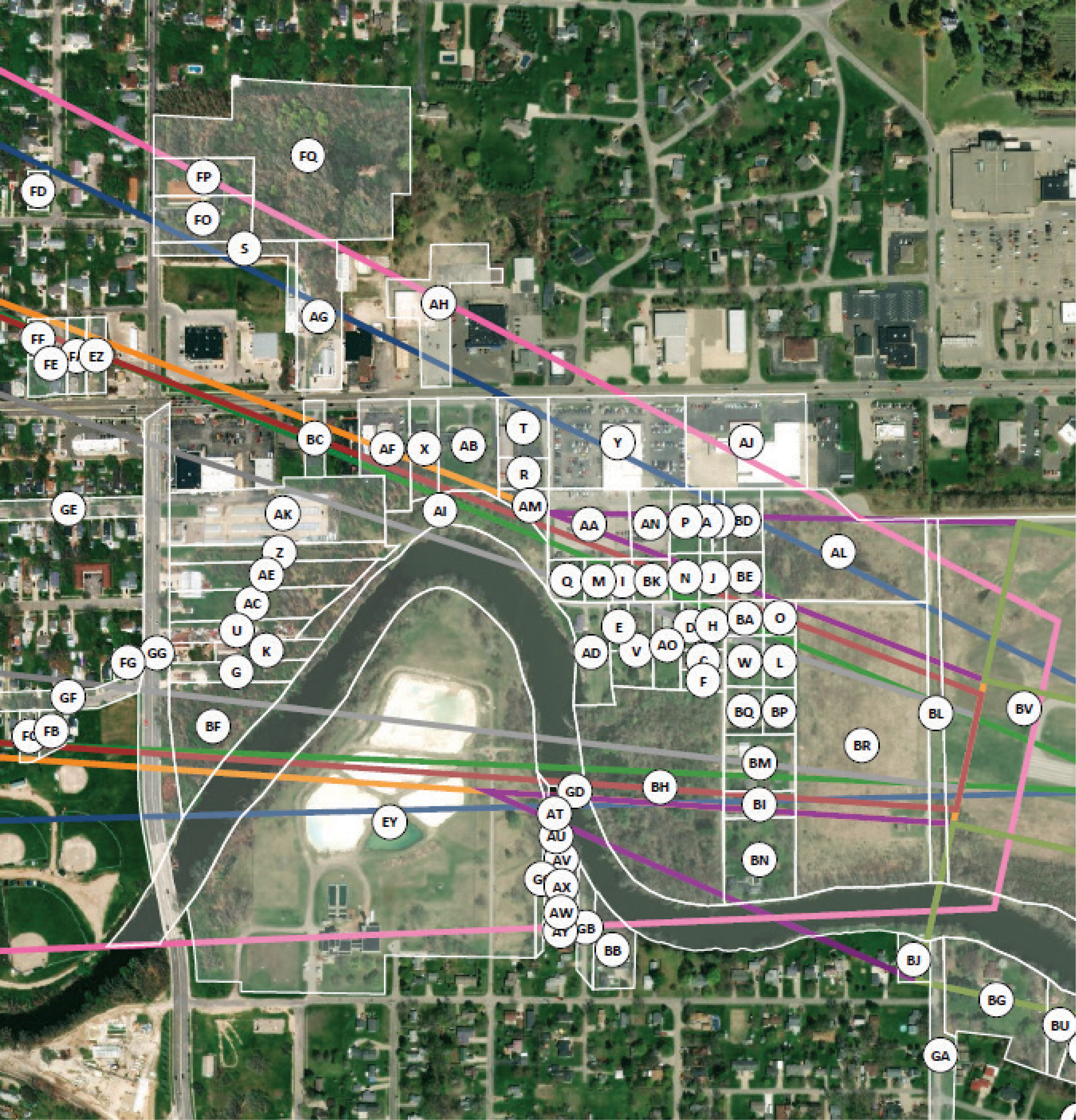
Figure 32 illustrates the obstructions for the primary runway only, and Figure 33 shows property impacts for the west approach. The airport and township addressed this large task through
Long Description.
The table is titled ‘Obstruction Resultsʼ. The column headers of the table are runway, aviation surface, parcels, obstruction, and potential. The row headers of the table are 11 and 29. Row 1: The first row has nine sub-rows: Sub-row 1: PAPI LSCS; 18; 20; 157. Sub-row 2: PAPI OCS; 23; 63; 213. Sub-row 3: Part 77 approach (cat A-dash NP) (20 to 1); 26; 230; 235. Sub-row 4: Part 77 approach transitional (7 to 1); 13; 204; 166. Sub-row 5: Part 77 runway transitional; (7 to 1); 15; 513; 195. Sub-row 6: Departure surface (RW Y29) (40 to 1); 81; 1,910; 427. Sub-row 7: Michigan state approach (20 to 1); 17; 90; 166. Sub-row 8: Threshold siting surface (cat 4) (20 is to 1); 23; 169; 222. Sub-row 9: Totals; 93; 2,325; 620. Row 2: The second row has nine sub-rows: Sub-row 1: NEW LCSC; 10; 9; 44. Sub-row 2: PAPI OCS: 12; 25; 57. Sub-row 3: Part 77 approach (cat A dash NP) (20 to 1); 11; 61; 75. Sub-row 4: Part 77 approach transitional (7 to 1); 7; 66; 62. Sub-row 5: Part 77 runway transitional (7 to 1); 15; 513; 195. Sub row 6: Departure surface (RW Y11) (40 to 1); 105; 1,088, 497. Sub-row 7: Michigan state approach (20 to 1); 8; 15; 37. Sub-row 8: Threshold siting surface (cat 4) (20 to 1); 11; 43; 64. Sub-row 9: Totals; 115; 1,602; 686. (Source: Caledonia township, Michigan).

Long Description.
The town shows a network of colorful star patterns and lines. These stars are concentrated in the central area, showing a focal point of activity or data collection. The lines extend outward in various directions. The surrounding landscape includes urban and rural areas, with visible roads and fields.
a phased approach, given the number of obstructions and the cost of addressing them. Years into the process, the obstructions have been reduced to six remaining trees, which are being remediated.
RNP had to be creative in addressing the obstructions, so the obstructions were divided into multiple phases, with those impeding state-licensed surfaces prioritized for removal. The main runway obstructions were also prioritized for Phase 1. In other areas, the airport had existing avigation easements, and the trees were removed without issues. Other parcels required meetings with landowners and working to gain the ownersʼ approval for airport contractors to remove trees.
Funding for the trimming and removals:
- Costs were well beyond what the airport and local government could provide, so they relied on state funds to address the obstructions.
- Eventually, funds were reimbursed from Michigan DOT (MDOT).
- Additional funds, if allowed, were used for tree removal, not just trimming.
Long Description.
The aerial map shows an urban area with numerous labeled points marked by circles containing letters. Various colored lines crisscross the map, indicating different pathways or routes. The map includes a river running through the center, surrounded by buildings, roads, and green spaces. The labels, such as AG, AH, and AL, are distributed across the map. The colored lines, including pink, orange, and blue, connect these points, showing a network or system within the area.
Key takeaways from RNP dealing with off-airport obstructions:
- The lidar study identified many obstructions that had been neglected for years, some of which became immediate priorities.
- The airport worked with MDOT on the identified obstructions and the required mitigation.
- While a good solution, purchasing easements was time-consuming and could be expensive.
- RNP noted that state regulations help protect both the airspace surrounding airports and the investment in public infrastructure.
Since 2021, RNP has addressed thousands of obstructions, and they are now down to only a few trees. The last six trees have been declared a nuisance because of their proximity to the runway and must be removed. Outreach to the landowner for removal has been challenging. As a result, the airport is working with the city to begin the legal process to remove the trees.
Addressing off-airport obstructions was a significant challenge for airport leadership. Having buy-in from local leaders and the airportʼs local representative at each property owner meeting ensured that meetings with nearly all residents went smoothly. Challenges identified by the airport during the identification and removal of obstructions include difficulties funding the removal of obstructions and providing technical assistance.


