Through-Running Regional Rail (2026)
Chapter: Case Studies
These through-running services are run as transit-style services, with short headways and frequent stops. They typically run on rights-of-way exclusive to RRM services while on the trunk-line sections in the city center, but they run on legacy rights-of-way shared with other services outside the core trunk line. RRM services sometimes may share physical tracks with other non-RRM rail services on legacy rights-of-way.
The study identifies the following best practices employed in the Paris RER, Munich S-Bahn, and London Crossrail systems:
- A new service type that complements, but does not replace, traditional commuter, intercity, or international service types
- Headway-based operations, with trains running at regular, repeating intervals
- Transit-style service, with all trains making all local stops and with short station dwell times
- Routing around or below existing terminal interlockings
- Uniform rolling stock types and performance
- Limited number of branch lines feeding a central trunk route
- Relatively short branch lines, generally serving urbanized areas
- Regional integrated fare payment systems
Philadelphiaʼs Regional Rail was inspired by European rail through-running. Commuter rail networks feeding into two Center City terminals were connected with a tunnel to enable through-running. While the physical trunk infrastructure resembles the trunks of the European RRM systems described earlier, service patterns and operating characteristics do not. Infrastructure outside the Center City tunnel was not optimized nor maintained to support the capacity needed for RRM service levels. As a result, service levels do not match those on peer RRM systems.
As of 2024, Toronto was pursuing an effort to transform its system into an RRM. Union Station and its interlockings and track leads were planned to be reconstructed to create a segregated corridor and station tracks specific to RRM services, effectively creating a through-running trunk line. Five of its seven lines were to be part of the new RRM configuration. Service on each branch was meant to be bidirectional, all-day, 15-minute (min) service. Four of these five RRM branches would through-run at Union Station, but the fifth branch would be turned back at Union Station. Rush-hour commuter trains would be run to the outer zones of the branches.
International Union of Railways Leaflet 406
International Union of Railways (UIC) Leaflet 406 (2013) is a technical document presenting a methodology for estimating railway line and junction capacity; it is used commonly in Europe (see Khadem Sameni et al. 2011). The methodology relies on a known timetable, whether real or generic, that can be used to assess the capacity of a section of railway.
For line capacity, a section of a rail line is examined during a period of interest. The timetable is used to produce train string-lines on a string-line chart. Signal blocks are denoted and blocked off as each string-line passes through those blocks, denoting occupancy of that block in two-dimensional space. To assess capacity during that time, the string-lines and their respective block occupation times are compressed on the graph to the maximum possible extent without any block occupation overlapping. The excess time on the graph divided by the total time during the period being assessed is used to identify that section of lineʼs unused capacity.
Junction capacity is determined using a similar methodology. Instead of looking at a section of railway line, a specific junction area or interlocking is studied over the period of interest. All sections or points of track within this junction that feature the start of a merging, diverging, or crossing conflict are identified and are treated as a block that may be occupied. Timetables and track assignments are used to create train string-lines and route paths and to identify which junction blocks will be occupied and when. The occupation times of these junction blocks can then be compressed to the point beyond which two trains would occupy a given block at the same time. The time needed to process all identified movements through the switch area is then identified.
CASE STUDIES
Several through-running regional rail lines from across the world were chosen for analysis to determine common characteristics of effective through-running services. These lines were the Munich S-Bahn, Seoul Metro Line 1, Tokyo Toei Asakusa Line, Brussels North–South Connection, Amsterdam Centraal, and Philadelphiaʼs Southeastern Pennsylvania Transportation Authority (SEPTA) Center City Commuter Connection (CCCC). This selection offers a spectrum of different through-running systems with different approaches to how services are run. This case study analysis shows that, despite these differences, several common themes emerge.
Munich S-Bahn Stammstrecke
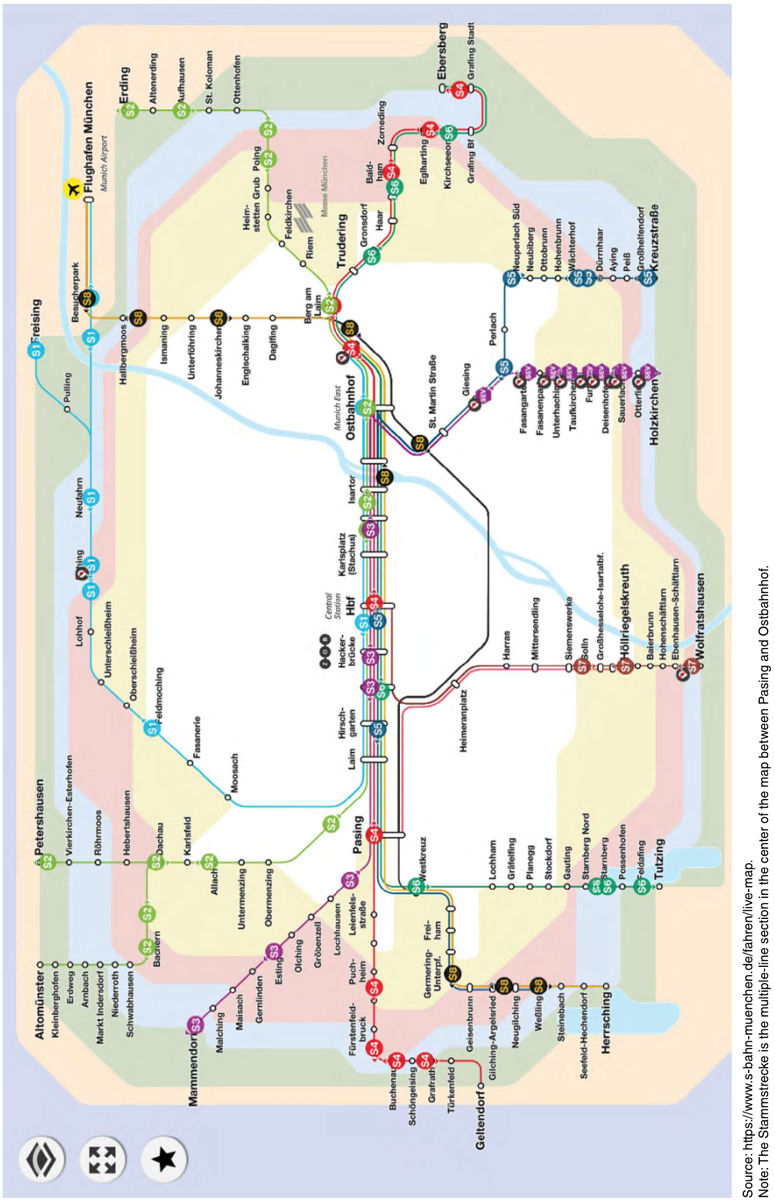
The Munich S-Bahn is an RRM created in the 1970s to unite suburban railway services that previously terminated at Munichʼs two major terminals: Hauptbahnhof and Ostbahnhof. The new trunk line, called the Stammstrecke, includes a tunnel between the two terminal stations with multiple stops in the city center. The S-Bahn lines using the Stammstrecke have six branches west of the Stammstrecke and six branches east of the Stammstrecke (Figure 2). The system operates transit-style service at regular intervals. Within the city center, the S-Bahn functions as an urban metro and is the primary means of east–west transit through the city center.
The Stammstrecke itself is a two-track railway that stretches from Pasing in the west, where four of the six branches from the west converge, to Ostbahnhof in the east, where the S-Bahn services split into either north or south directions. Railway lines from the west connecting to Hauptbahnhof converge on a corridor of track leads that include junctions and flyovers leading to Hauptbahnhof. The Pasing–Hauptbahnhof section of the Stammstrecke runs within this corridor but physically grade separates S-Bahn service from all other Hauptbahnhof-bound services to avoid mixing service on the trunk. S-Bahn services merge into the Stammstrecke with grade-separated junctions. The city-center section of the Stammstrecke supports 30 trains per hour per direction, offering high-frequency service that functionally is an urban metro. This frequency is in part enabled by a moving-block signaling system.
Long Description.
The rail network map presents multiple S Bahn lines labeled S1, S2, S3, S4, S5, S6, S7, and S8 connecting stations across Munich. A central section between Pasing and Ostbahnhof is shared by several lines and includes stations such as Laim, Hackerbrücke, Karlsplatz, Stachus, and Isartor. From Pasing, routes extend toward stations such as Germering Unterpfaffenhofen, Freiham, and further west. From Ostbahnhof, routes extend toward stations such as Trudering, Grafing Bahnhof, and Ebersberg. Other branches connect to Herrsching, Tutzing, Wolfratshausen, Kreuzstrabe, Erding, and Flughafen München. Stations such as Freising, Petershausen, Mammendorf, Geltendorf, Giesing, Deisenhofen, Holzkirchen, Neuperlach Sud, and Garching are also shown along different lines. The map includes multiple intersecting routes and station connections across the network. Source: https://www.s-bahn-muenchen.de/fahren/live-map. Note: The Stammstrecke is the multiple-line section in the center of the map between Pasing and Ostbahnhof.
The outlying branches generally minimize interfacing with other rail traffic while not necessarily eliminating it. Of the S-Bahnʼs 12 branches, 6 physically avoid mixing with other rail traffic by either using branches dedicated to S-Bahn service or using tracks dedicated to S-Bahn services within corridors shared with other rail services. Of the remaining branches that do mix with other rail services, three services run on branches that see relatively low traffic. Junctions along the S-Bahn system are also entirely grade separated, minimizing unnecessary delay between otherwise conflicting train movements.
The entire system runs on regular headways. Every branch either runs every 10 mins or every 20 mins and fits into the 30 train slots available in the Stammstrecke at regular intervals. Having trains arrive and depart at consistent headways scheduled around Stammstrecke meets, while having minimal meets with other trains outside the Stammstrecke, enables trains to merge without holds or delays as long as every train is on time. This approach enables Munich to extract a higher capacity out of its trunk line than other through-running systems achieve.
The Munich S-Bahn has several notable characteristics:
- Thirty trains per hour on a two-track trunk line is the highest throughput of the lines examined. This throughput is enabled by the high-capacity signaling system in the Stammstrecke and the clock-face scheduling that revolves around merges at strategic points.
- The S-Bahn branches mostly operate on lines that either have dedicated S-Bahn tracks or mix with lower volumes of traffic.
- Some stations in the city center have platforms on both sides of each track to facilitate faster boarding and alighting.
Seoul Metro Line 1
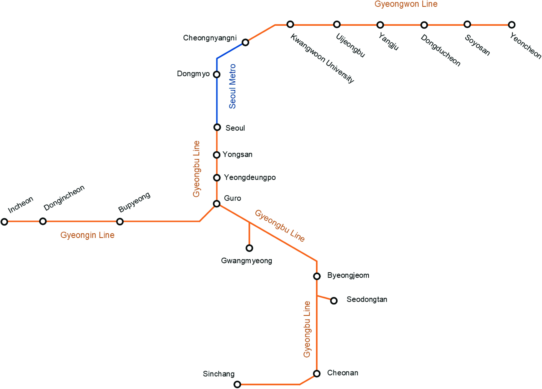
The Seoul Metro, similar to the Tokyo Metro, through-runs suburban trains on urban metro tracks. Line 1 was the first metro built in Seoul and has the most extensive and complex suburban through-running operation of the Seoul metro lines. Line 1 consists of four total lines: the core metro tunnel owned by Seoul Metro and three lines owned by Korail, the national railway operator. Figure 3 is a map of Line 1 that depicts stations where trains originate and terminate, along with other noteworthy stations. The blue section indicates the metro section of Line 1, and the orange sections indicate Korail lines.
The core metro line was built between Seoul Station and Cheongnyangi with stations spaced approximately one-half mile apart. At Seoul and Cheongnyangi, Line 1 switches from the core
Long Description.
The metro map presents stations connected by routes. The line labeled Seoul Metro is blue and runs north from Seoul to Dongmyo and Cheongnyangni. South from Seoul on the Gyeongbu Line are Yongsan, Yeongdeungpo, and Guro. Continuing east from Cheongnyangni at the northern end of the Seoul Metro line, the Gyeongwon Line route continues to Kwangwoon University, Uijeongbu, Yangju, Dongducheon, Soyosan, and Yeoncheon. From Guro, on the Gyeongbu Line, one branch leads east to Gwangmyeong, south to Byeongjeom, Seodongtan, and Cheonan, which extends west to Sinchang. From Guro, on the Gyeongin Line, another route travels west and connects to Bupyeong, Dongincheon, and Incheon.
metro tunnel section onto Korail tracks. Line 1 trains operate on suburban Korail lines to Yeoncheon in the north and Incheon and Sinchang in the south. Both Seoul Metro and Korail trains through-run the metro tunnel section as part of Line 1 service.
Line 1 trains operate on Korail-owned rights-of-way and tracks, but most Line 1 trains do not share tracks with any other services. Korailʼs Gyeongwon Line tracks from Cheongnyangi to Yeoncheon and its Gyeongin Line tracks from Goru to Incheon are exclusively for the use of Line 1 services. Korailʼs Gyeongbu Line, used by Line 1 trains between Seoul Station and Seodongtan, is a major north–south intercity rail corridor. Local Line 1 trains on the Gyeongbu Line operate on tracks separate from other services; the less-frequent Line 1 express services often share tracks with the corridorʼs intercity trains. In addition, express trains from Dongincheon share tracks with Korail services between Goru and Yongsan. All junctions throughout Line 1 are fully grade separated. Minimizing track sharing with non-Line 1 services and using grade-separated junctions dramatically simplifies through-running suburban services in Seoul.
Roughly two-thirds of all Line 1 trains fully through-run the city-center metro section. Roughly one-third of all trains coming from the south terminate at Yongsan station, 2 miles from the Seoul CBD. The trains that terminate at Yongsan are mostly express trains from Dongincheon. To simplify Line 1 operations, Dongincheon express trains do not share tracks with Incheon locals on the Gyeongin Line and do not mix with other Line 1 services at Guro. This operation results in about 22 trains per hour per direction south of Yongsan but only 15 trains per hour per direction within the city-center metro section.
As of 2025, train congestion on the line prevents the city-center metro tunnel from exceeding 15 trains per hour. Trains operate with significant recovery time to account for rush-hour delays.
Line 1 is a service that varies from Western through-running operations in several ways:
- Line 1 services operate on tracks that are almost completely separated from other rail services. This arrangement allows Line 1 operations to run a frequent operation that resembles rapid transit more than RRMs seen in most Western cities.
- Line 1 stop spacing is only one-half mile in the city center, though many RRM operations in the West tend to use greater stop spacing. Shorter stop spacing provides greater accessibility within the urban core, but it increases cross-regional travel times and requires higher construction costs.
- Line 1 sees significantly less train volumes through its core trunk section through the CBD than in the section south of Yongsan. Although terminating some RRM lines at an urban terminal outside of the trunk line is not uncommon, the volume of trains being terminated at Yongsan rather than being through-run the metro section is unusual.
Tokyo Toei Asakusa Line
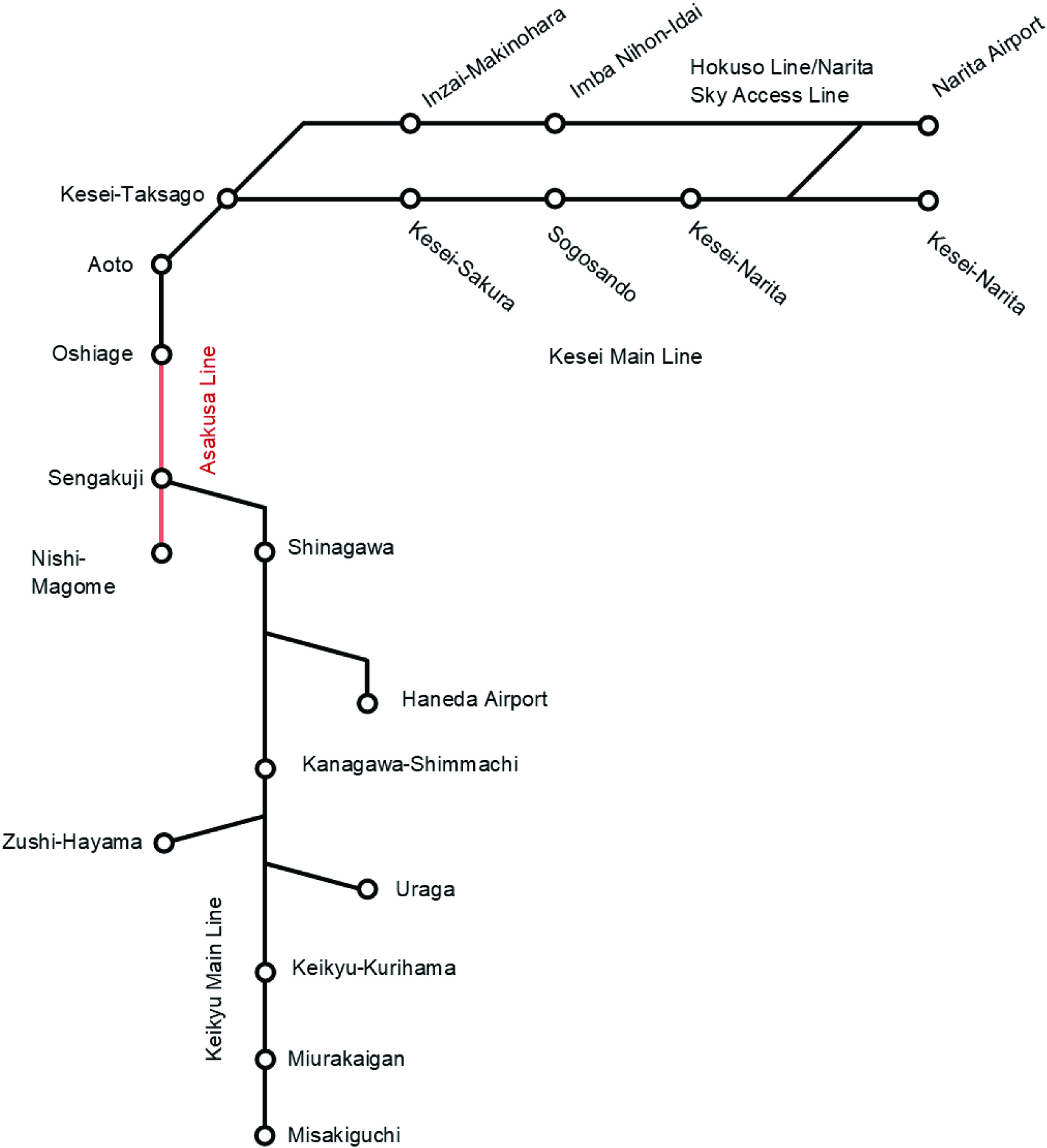
Tokyoʼs Toei Subway is a smaller subway system that competes with the larger Tokyo Metro and JR East systems. The Toei Asakusa Line was the first urban metro line in Tokyo to accommodate through-running suburban trains and remains the most complex through-running operation in Tokyo. The Asakusa Line was built between Nishi-magome in the south and Oshiage in the north with stations spaced approximately one-half mile apart. At Sengakuji, the Asakusa Line connects to Keikyu Corporationʼs Main Line to the south, including three branch lines to Haneda Airport, Zushi-Hayama, and Uraga. At Oshiage, the Asakusa Line connects to Keisei Electric Railwayʼs Oshiage Line, Main Line, and Sky Access Line, to Hokuso Railwayʼs Hokuso Line, and to the Shibayama Railway to the north. The Asakusa Line has its own southern terminal at Nishi-magome that does not offer through service. A diagram of the Asakusa Line and its through-running services is shown in Figure 4. Stations where trains terminate and originate and other noteworthy stations are identified. The red section indicates the Asakusa Line itself. The black sections indicate the suburban Keikyu and Keisei Railway services that through-run with the Asakusa Line.
The Asakusa Line itself carries 22 trains per hour per direction during peak hours, most of which are trains that are through-run with the Keikyu Main Line or the Keisei Railway, or both. Despite complex rail operations outside the Asakusa Line, the Asakusa Line itself maintains 22 trains per hour through the core trunk. All trains regardless of destination or express/local designation make all stops along the Asakusa Line.
Unlike Seoul Metro Line 1, trains through-running on the Asakusa Line are not segregated from other services outside the core trunk line, and various stopping patterns are run on the same tracks. The Keikyu and Keisei railways run substantial volumes of trains that share tracks and contend for slots with through-running Asakusa Line trains. Roughly 54% of trains on the Keikyu Main Line bound for Tokyoʼs city center through-run onto the Asakusa Line; the other 46% of trains bound for Tokyoʼs city center terminate at Shinagawa rather than through-run. In addition, local trains with shorter runs also run on the Keikyu Main Line and its various branches. The Keikyu Main Line is a two-track line but runs a variety of local and express stopping patterns.
The Keisei Railway and its connecting railways run a more complex operation. The Keisei Main Line and Sky Access Line form the two trunk lines leading from Narita Airport; these merge into a single trunk at Keisei-Takasago. At the following stop, Aoto, these trains either head to Oshiage to through-run on the Asakusa Line or to Keisei-Ueno to terminate. Both trunk lines have various branches and run varieties of local and express stopping patterns. In addition, tracks are shared with JR services within Narita Airport. All services on the Sky Access Line are bound for the Asakusa Line, but only 32% of services on the Keisei Main Line go to the Asakusa Line; the other 68% go to Keisei-Ueno.
The Keikyu Railway and Keisei Railway operating plans represent a markedly more complex through-running operation compared with similar RRM systems around the world. High volumes of trains with different operating patterns and with different origins and destinations mix on two-track railway sections. Many of these services are enabled by track, junction, and station designs that maximize separating services onto separate tracks and minimizing operating conflicts. Because of the complexity of the network, a great level of operating precision is needed to ensure that trains reliably meet their slots.
Toei Asakusa Line through service varies from Western through-running operations in several ways:
- Asakusa Line stop spacing is only one-half mile in the city center; many RRM operations in the West tend to have longer stop spacing. Shorter stop spacing provides greater accessibility within
Long Description.
The railway diagram presents stations connected by routes. The line labeled Asakusa Line travels north and south, connecting Nishi Magome, Sengakuji, and Oshiage. From Sengakuji, the Keikyu Main Line branches off traveling south connecting to Shinagawa, Kanagawa Shimmachi, Keikyu Kurihama, Miurakaigan, and Misakiguchi, with branches to Haneda Airport, Zushi Hayama, and Uraga. From Oshiage at the north end of the Asakusa Line, the Keisei Main Line connects to Aoto and Kesei Takasago, and continues on through Kesei Sakura, Sogosando, and Kesei Narita. The Hokusou Line or Narita Sky Access Line branches off from Kesei-Takasago connecting Inzai Makinohara, Imba Nihon Idai, and Narita Airport.
the urban core, but it increases cross-regional travel times and requires higher construction costs.
- Given the service complexity on the branches, the frequency of the through-running service is high. Five branches approach the core trunk of the Asakusa Line from the south and effectively three branches approach the Asakusa Line from the north. Through services on the Asakusa Line constitute only a portion of the overall railway service that operates on these branches. Stopping patterns on these branches are a spectrum of local to express trains. These kinds of operating conditions typically would necessitate less-frequent service both on the branches and in the trunk and would affect overall reliability such that service plans would call for a simplification of service.
Brussels Noord-Zuidverbinding (North–South Connection)
Brussels completed a through-running connection in the 1950s between its two major terminals—Zuid-Midi and Noord-Nord (referred to as “Midi” and “Noord” in the remainder of this case study). The through-running connection is known as the Noord-Zuidverbinding (North–South Connection). It consists of a six-track trunk line through the city center. Unlike most examples of through-running infrastructure in these studies, the North–South Connection is not dedicated exclusively to regional rail services; instead it serves as a conduit for all high-speed, intercity, and regional services on the right-of-way. The same tracks are used for all three service types, leading to every type of train mixing on nearly every track—an RMS. The main feature of Brusselʼs regional rail service is its S train, a series of numbered services that run routes on clock-face schedules throughout the Brussels metropolitan area and extending to towns and cities just outside the metropolitan area.
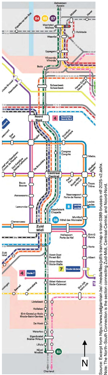
South of Midi Station, lines from five directions converge onto one corridor (Figure 5). Various flyovers are incorporated into this joint corridor that permit trains to be positioned for tracks that roughly correspond to their outgoing lines north of Noord Station. Approaching Midi Station from either side, flat interlockings are used
Long Description.
The railway map presents stations connected by multiple routes. The section connects Zuid Midi, Centraal Central, and Noord Nord. Several lines intersect at these stations, including routes labeled S1, and S8. Stations such as Scheerbeek, and Vilvoorde appear along the routes. Source: Excerpt from https://www.belgiantrain.be/-/media/files/pdf/s-train/map-s-train-0389-brussels-nlf-2025-v2.ashx. Note: The North–South Connection is the section connecting Zuid-Midi, Centraal-Central, and Noord-Nord.
to send trains to their assigned platform track. Trains are assigned station tracks within zones that roughly correspond with the positioning of their incoming and outgoing track assignments. Although flyovers minimize conflicts, trains sometimes make movements across these interlockings that could obstruct other train movements. No further crossovers exist beyond the Midi Station interlockings until the Noord Station interlockings. Trains that enter the six-track North–South Connection from the Midi interlockings on a track will remain on that track until reaching the Noord interlockings.
The North–South Connection introduced three new stations in the city center: Brussels-Congress, Brussels-Central, and Brussels-Chapel. Brussels-Central is the largest and busiest of these stations. Its location near the historic medieval city center and the presence of a metro connection to major employment centers makes it a major commuter destination for residents across the entire country. Nearly all S trains and intercity trains stop at Central. Congress and Chapel, on the other hand, are very minor stations, served only once per hour and twice per hour, respectively, by the S1 Line.
Outside the North–South Connection, intercity, local, and S trains generally mix on main lines. Most of these two- or four-track main lines have completely or partially grade-separated junctions.
Unlike most through-running regional rail systems examined in these studies, the S train system runs only 1–2 trains per hour per direction per route and 12–13 trains per hour per direction on the North–South Connection. A total of 35 trains per hour per direction (including intercity trains) move through the North–South Connection. Although most major junctions have flyovers to segregate conflicting movements, the mixing of intercity and regional trains on the same tracks leads to scheduling conflicts and hampers the frequency of S trains that can be run. In turn, this means the North–South Connection, despite having many aspects of the infrastructure needed to support RRM, has service levels that are not adequate to be useful as a metro-like service.
The North–South Connection differs from other through-running services in several ways:
- Regional, intercity, and high-speed services are all mixed on the same tracks. Different stopping patterns on different tracks inherently lead to the inability to fully take advantage of the infrastructureʼs capacity.
- S train frequencies are low. During peak hours, lines run only one to two trains per hour with even less-frequent service in off-peak hours and weekends. Although the low frequency might be acceptable to commuters on a traditional commuting schedule in the city center, it is not suitable for transit purposes.
- Two of the five stations in the North–South Connection receive only S1 service, meaning that they are served only once or twice per hour. This makes them difficult to use for urban transit despite being in the city center.
Amsterdam Centraal Station
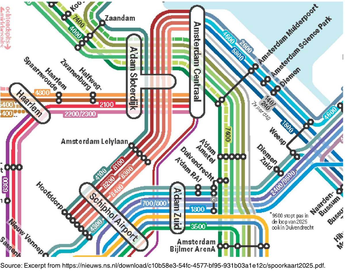
Amsterdam Centraal Station is a central node of the Dutch railway system. It was previously treated as a terminal station with approaches from both sides, but some regional and intercity services were converted to through-running to improve capacity. Unlike other systems studied here that typically offer multiple city-center stations along a trunk line, Amsterdam Centraal is one station in the city center where several rail lines converge from two directions onto a common trunk corridor. This setup is more typical of major rail stations in many parts of the world, but the same lessons concerning through-running still apply. Amsterdam Centraal Station itself consists of 15 tracks, 14 of which are through tracks. Of the 14 through tracks, 4 tracks are runaround tracks without platform edges, leaving 10 total through-running tracks. Each platform edge is subdivided into an A side on the western half of the platform and a B side on the eastern half of the platform.
The trunk corridor originates near Sloterdijk Station in the west to Muiderpoort Station in the east, spanning roughly 6 miles (Figure 6). At Sloterdijk, lines from Haarlem and Zaandam meet and tie into the same corridor, and a third line from Schiphol Airport and the Amsterdam Ringspoorbaan ring railway passes overhead. However, it is not until a junction roughly 1.5 miles east of Sloterdijk that these three lines meet in a grade-separated junction, which avoids mixing. East of this junction, services from the Ringspoorbaan and Schiphol Airport are kept on the northernmost tracks, services from Zaandam in the middle tracks, and services from Haarlem on the southernmost tracks. This rough geographic division of track assignments is maintained in corresponding zones of tracks at Amsterdam Centraal Station. Lines at Muiderpoort Station in the east converge from Weesp and Amstel stations. West of Muiderpoort Station, services from Weesp occupy the northernmost tracks and services from Amstel occupy the southernmost tracks. Services to and from Zaandam are generally through-run with services to and from Weesp, and through services to and from Schiphol are through-run with services to Amstel. Services from Haarlem terminate at Amsterdam Centraal. Through-running services in this manner avoid crossing conflicts on the trunk corridor. Some local services via Zaandam terminate at Amsterdam Central on the same southern tracks as Haarlem services. Because the junction west of Sloterdijk is grade separated, this route does not cause crossing conflicts.
Service mixing of regional, intercity, and high-speed trains is common in the Amsterdam Centraal trunk corridors and on railway lines throughout the country. Railway lines feeding Amsterdam Centraal are typically either two- or four-track railways. Most junctions are grade separated, minimizing crossing conflicts. However, the mixing of services with a variety of service patterns on some tracks constrains capacity.
As a result of its blended system approach, Amsterdam Centraal typically sees four to seven trains per hour per station track. Service mixing on the outlying network is a major contributor to this throughput, but through-running trains also layover at Amsterdam Centraal anywhere from 1 to 15 mins.
Philadelphia Regional Rail CCCC
Philadelphiaʼs Regional Rail system is composed of what was originally two separate commuter rail systems developed by two railroad companies, the Pennsylvania Railroad and the Reading Railroad, each with their own terminal. These two systems are now connected with a through-running tunnel in Center City. Each half of the unified system contains six branches with the mainline trunk. Branches from each half of the system were originally paired with another branch from the other half of the system based on ridership and operational needs, but this operation has since been changed to assigning
Long Description.
The railway map presents stations connected by many routes with service numbers. Stations include Amsterdam Centraal, Adam Sloterdijk, Haarlem, Zaandam, Amsterdam Amstel, Duivendrecht, Adam Zuid, Schiphol Airport, Amsterdam Bijlmer Arena, Weesp, Diemen, and Diemen Zuid. Routes with numbers 1500, 1800, 2600, 2400, 9500, 3500, 8100, 4100, 4600, 700, and 800 connect these stations. The routes pass through Amsterdam Science Park and Amsterdam Muiderpoort and continue toward nearby stations. Multiple lines join and split among Amsterdam Centraal, Adam Sloterdijk, and Adam Zuid, forming connections to Schiphol Airport and Amsterdam Bijlmer Arena. Source: Excerpt from https://nieuws.ns.nl/download/c10b58e3-54fc-4577-bf95-931b03a1e12c/spoorkaart2025.pdf.
branch pairs on a train-by-train basis. The trunk line contains five stations, three of which are in Center City.
The SEPTA Regional Rail trunk line, known as the CCCC, begins at the upper level of 30th Street Station, which is dedicated entirely to regional rail trains. Isolating SEPTA Regional Rail trains from the interlockings and station platforms of the Northeast Corridor at this station reduces conflicts with other train services. After 30th Street, the CCCC narrows to a four-track mainline. At Suburban Station, a transit hub for metro and streetcar services, stub-end tracks facing 30th Street are provided for trains turning back toward the former Pennsylvania Railroad branches. The CCCC makes three more stops, including one in Center City, before branching out to former Reading Railroad branches. Crews change at one of the three major City Center stations, requiring a layover of several minutes before continuing. Notably, trains may operate on paired branches that require conflicting movements. These movements are made on flat interlockings within the CCCC. The tunnel portion of the CCCC also sees speeds restricted to under 25 miles per hour, which makes it less time-competitive for cross-regional and intra-urban trips. The CCCC was designed for a capacity of up to 44 trains per hour in each direction or 22 trains per hour for each track. However, during the peak hour in 2025, about 14 trains per hour used the tunnel in each direction, meaning that a large portion of the trunk-line capacity is left unused.
Beyond the CCCC, SEPTA Regional Rail operations have several notable characteristics. Most platforms in the system tend to be low platforms that necessitate longer dwell times for people climbing stairs onto and off of trains and for assisting passengers with disabilities. The Reading Railroad half of the system almost entirely uses at-grade junctions, which constrain the whole systemʼs capacity. Trains on the Lansdale/Doylestown Line, one of the highest ridership lines in the system, need to cross five at-grade junctions with other Regional Rail services before entering the CCCC. On the other hand, the former Pennsylvania Railroad branches are grade separated in most places.
The SEPTA Regional Rail system generally follows the model of a traditional American commuter rail system that happens to have a through-running tunnel. It operates using traditional suburb-to-CBD travel patterns. About 95% of trips begin or end in Center City; over time, the operating plan has shifted away from consistent assigned branch-to-branch trip pairs to prioritize these trips. Although 28 trains per hour enter the CCCC from the suburbs, only 18 trains per hour move in the reverse-peak direction. Low frequency and a lack of fare payment integration with the local metro, streetcar, and bus system prevent it from being an integral part of travel between points within the City of Philadelphia.
The SEPTA Regional Rail system differs from other through-running regional rail systems in several ways:
- A significant portion of the systemʼs junctions and interlockings are flat. With the myriad of merging branches and mixing with freight and intercity passenger services, this design can lead to capacity constraints and greater risk of delays.
- Fares are not integrated with the urban transit system. This reduces the attractiveness of using regional rail as a service for residents within the City of Philadelphia.
- Frequencies are low. During the peak hour, lines operate only two to four trains per hour, with fewer trains during off-peak periods


