Preparing Successful No-Effect and No-Adverse-Effect Section 106 Determinations: A Handbook for Transportation Cultural Resource Practitioners (2025)
Chapter: Appendix: Complete Case Studies
APPENDIX
Complete Case Studies
ADA Improvements to U.S.-266, Checotah, McIntosh County, OK
I-495 NEXT Project, Fairfax County, VA
Tribal Affairs Program, Wisconsin Department of Transportation
Bridge Street Bridge Rehabilitation, Stewartstown–Canaan 15838, Stewartstown, NH, and Canaan, VT
SR 4001/English Center Suspension Bridge Rehabilitation, Pine Township, Lycoming County, PA
U.S. Highway 12 Widening Project, Lochsa Ranger Station to Holly Creek Turnout, Idaho County, ID
Iowa Highway 31, Little Sioux Riverbank Stabilization, Woodbury County, IA
Widen I-285 Top End Express Lanes and Flyover Ramps, Cobb, Fulton, and Dekalb Counties, GA
Route 16 Improvements, Ossipee 41251, Ossipee, Carroll County, NH
U.S.-79 from I-35 to East of FM 1460, Widening and Improvements, Round Rock, Williamson County, TX
ADA Improvements to U.S.-266, Checotah, McIntosh County, OK
Project Description
The Oklahoma Department of Transportation (DOT) proposed sidewalk improvements to U.S.-266 from Northwest 6th Street to Main Street in Checotah, McIntosh County, Oklahoma. The purpose of the project was to improve pedestrian safety to meet ADA standards. The proposed project included the following improvements.
- Five-foot sidewalks with curb and gutter reconstruction in concrete;
- Americans with Disabilities Act (ADA)-compliant Type B ramps, tactical devices, crosswalk markings, and signage at intersections;
- Bump-outs at three intersections; and
- Driveway reconstruction.
Cultural Resource Findings
The project boundaries are located within the Checotah Business District, which was listed in the National Register in 1981 under Criteria A and C for its associations with commercial center development as a result of railroad expansion and for its collection of architectural styles locally (ACHP 2020).
The Oklahoma DOT initiated Section 106 consultation with the Oklahoma State Historic Preservation Office (SHPO) and the public in May 2020 and with recognized tribes in July 2020 (Oklahoma DOT 2020, attachments). At that time, the Oklahoma DOT requested any initial comments from the Oklahoma SHPO on the undertaking. In response, the Oklahoma SHPO posed two questions for the Oklahoma DOT to consider when conducting cultural resource surveys of the project area (Oklahoma SHPO 2020):
- Since the 1981 NRHP [National Register of Historic Places] nomination, has the Checotah Business Historic District retained its integrity that made it eligible for listing in the NRHP?
- What kind of direct and indirect effects will the proposed sidewalk project have on the historic district?
In a Cultural Resources Survey Report for the project, the Oklahoma DOT Cultural Resources program reported a finding of No Adverse Effect to historic properties identified in and adjacent to the project area (Oklahoma DOT 2020). Identified historic properties included the historic district as well as the individually listed Methodist Episcopal Church and the Old Checotah City Hall. As a result of the survey, no archaeological resources or newly identified architectural resources were recommended as eligible for listing in the National Register; however, a new boundary was proposed for the Checotah Business District to remove noncontributing elements. For all historic properties, the Oklahoma DOT concluded that the proposed new bump-outs and ADA ramps would be compatible in character and quality with the district and would not diminish the important aspects of setting, feeling, or association that convey their significance, and, therefore, the project would have No Adverse Effect on them. The Oklahoma DOT also identified two cemeteries within 1 mile of the project stipulated to be avoided for use for off-project facilities, such as heavy equipment staging areas. This stipulation was made to avoid impacts to cultural resources that have not been assessed for National Register eligibility.
In a letter dated July 24, 2020, the Oklahoma SHPO concurred with the finding of No Adverse Effect to the church, city hall, and properties outside the historic district; however, concurrence of No Adverse Effect to the Checotah Business District was stipulated with conditions. In disagreement with the Oklahoma DOT, the Oklahoma SHPO requested the removal of selected proposed bump-out features within the boundaries of the historic district to agree on the finding.
Following receipt of notification of the disagreement from the Oklahoma DOT, the FHWA Oklahoma Division (FHWA-OK) requested a dispute resolution from the Advisory Council on Historic Preservation (ACHP) on August 7, 2020. ACHP responded in a letter dated August 20, 2020, affirming the finding of No Adverse Effect, citing the following reasonings (ACHP 2020):
- The District significance is focused on the architectural value and visual elements of the structures; aspects of the roadway and streetscape (where bump-outs would be constructed) are not mentioned or identified as contributing elements.
- Therefore, because the bump-outs would affect the streetscape and not the significant architectural and visual aspects of the District, the character-defining features would be retained and the function and integrity of the structures in the District would not be affected.
As a result of this project, FHWA-OK identified a handful of useful strategies for reaching findings of effect concerning projects with ADA/streetscape improvements to a historic district:
- Allow the SHPO, other consulting parties, and the public to comment as early in the project planning process as possible to allow time to consider input and address questions on the project (FHWA-OK 2020).
- Conduct multiple consultation meetings with the SHPO to clarify engineering designs with potential effects on historic properties.
- Use reoccurring meetings with the SHPO to discuss projects at early planning stages.
- Address each project individually. Precedents from other projects may not apply to every historic property type (e.g., bump-outs may be appropriate in some historic districts but not others, on the basis of historic characteristics and significance).
- Address streetscape improvement projects programmatically.
The Oklahoma DOT is drafting a programmatic agreement to streamline Section 106 review of streetscape improvements in towns.
References
| Advisory Council on Historic Preservation (ACHP) | |
| 2020 | Ref: Proposed ADA Improvements to U.S.-266 from Northwest 6th to Main Street, Checotah, McIntosh County, OK (ACHP Project Number: 015811). ACHP, Office of Federal Agency Programs, Washington, DC, August 20. On file, ACHP, Washington, DC. |
| FHWA, Oklahoma Division (FHWA-OK) | |
| 2020 | Re: ACHP Project 015811: Proposed ADA Improvements to U.S.-266 from Northwest 6th to Main Street, Checotah, McIntosh County, OK; (ODOT JP 32839(04). Letter to Reid Nelson, ACHP, Washington, DC, from Karen Orton, FHWA, Oklahoma Division, Oklahoma City, OK, September 14. On File at Oklahoma DOT. |
| Oklahoma DOT | |
| 2020 | Cultural Resources Survey Report: McIntosh 32839(04): US-266 ADA Improvements in Checotah. Prepared by the Oklahoma DOT Cultural Resources Program, Oklahoma City, OK, June 24. On File at Oklahoma DOT. |
| Oklahoma State Historic Preservation Office (Oklahoma SHPO) | |
| 2020 | Re: File #1729-20; Checotah Proposed Sidewalks Improvements Project Along US-266, #JP-32839(04), McIntosh County. Letter to Scott Sundermeyer, Oklahoma DOT, Norman, OK, from Lynda Ozan, Oklahoma SHPO, Oklahoma City, OK, May 27. On file at Oklahoma DOT. |
I-495 NEXT Project, Fairfax County, VA
Project Description
Beginning in 2018, the Virginia Department of Transportation (VDOT) proposed improvements to I-495 between the Dulles Toll Road (SR 267) and the George Washington Memorial Parkway (GWMP) interchange in the vicinity of the American Legion Bridge and began preparing
an environmental assessment (EA) for the project (VDOT 2020a). The purpose of the project, entitled the “I-495 Express Lanes Northern Extension (NEXT) Project,” is to reduce congestion, provide additional travel choices, and improve travel reliability. The proposed project includes the following elements:
- Alteration of the GWMP configuration by extending the existing merge taper for approximately 1,150 feet within the National Register boundaries of the GWMP,
- Gateway entrance to the GWMP off I-495 with clear signage identifying the GWMP to drivers, and
- Merging of the express lanes and general-purpose lanes from I-495 from the south onto the GWMP.
Cultural Resource Findings
VDOT coordinated an initial cultural resources survey of most of the area of potential effects (APE) in April and May 2019. Additional survey efforts were conducted in July 2019 on behalf of the Maryland State Highway Administration and VDOT to identify any archaeological resources within the Maryland Managed Lanes Study area and I-495 NEXT projects within the GWMP. In January 2020, following these surveys, VDOT revised the design of the proposed project, which resulted in a subsequent revision of the APE. Expanded portions of the APE were covered by the previous survey conducted in July 2019, where no archaeological resources were identified. Remaining portions of the APE for archaeological resources (within the limits of disturbance) did not warrant an archaeological survey, as the ground was previously modified or featured an excessive slope. Along with the GWMP, only one previously surveyed architectural resource was identified within the revised APE: the Tysons Corner mall [Virginia Department of Historic Resources (VDHR) No. 029-6464]. On the basis of these comprehensive survey results and the project design, VDOT determined that the GWMP was the only historic property in the APE that would be affected by the undertaking.
The GWMP was listed in the National Register in 1995 and recorded as a cultural landscape by the National Park Service (NPS) in 2009. Table A-1 outlines the important features of the GWMP and how effects were assessed for the project. Overall, VDOT maintains that, “while the proposed project may alter the setting and feeling of the GWMP, the project does
Table A-1. Assessment of effects on important features of the GWMP.
| Important Feature | Assessment of Effects |
|---|---|
| National Register boundary | The I-495/GWMP interchange, where most of the proposed project elements are located, is specifically excluded from the National Register nomination form as part of the historic property. |
| Views of the Potomac Palisades | Element located outside APE—no effect. |
| Stone walls | Element located outside APE—no effect. |
| Tree canopy | Alteration of the canopy expected to occur as a result of four gateway options in an area that had minimal forest cover during the GWMP’s period of significance. Alterations to the canopy will not diminish the feature overall. |
| Parkway configuration | Alteration of the parkway configuration expected to occur by extending the existing merge taper by approximately 1,150 feet within the National Register boundary of the property. Alterations to the configuration will not diminish the feature overall. |
not diminish any aspects of integrity that contribute to the significance of the resource” (VDOT 2020a:4).
Proposed Design
As part of the EA, VDOT committed to working closely with NPS and consulting parties to develop a project design that appropriately considers the setting and feeling of the GWMP. The design team had the specific goal of minimizing visual and physical impacts to the resource while incorporating a design that creates a “gateway entrance” to the GWMP off I-495. In early stages of Section 106 consultation, NPS requested that VDOT develop a design that “clearly identifies the GWMP to drivers.” Given this direction from NPS, VDOT created a visualizations booklet (VDOT 2020b) to present design options and facilitate discussion of the design with consulting parties (Figures A-1, A-2, and A-3).
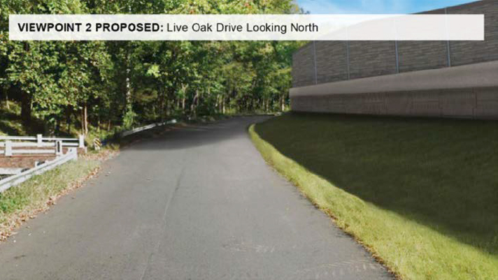

Finding of Effect
Both NPS and VDHR preferred Option 1. VDOT moved forward with Design Option 1 and committed to implementing the following conditions to successfully reach a finding of No Adverse Effect with Conditions, with which VDHR concurred (VDOT 2020a:7):
- VDOT shall include design constraints in the Request for Proposals requiring the design-builder to remain within the current LOD [limits of disturbance] where possible in designing and constructing project improvements in the vicinity of archaeological sites.
- VDOT shall ensure that safety fencing is erected along the LOD to ensure avoidance of any ground disturbance to identified archaeological sites during construction of the project, or by construction vehicles entering and leaving the project corridor. VDOT shall include a Special Provision requiring installation of the safety fence in contract with the design-builder.
- VDOT shall implement a “gateway” option selected by the GWMP in a manner generally consistent with the visualizations for that option depicted in the Booklet dated February 6, 2020, and in continuing consultation with the GWMP and the Virginia SHPO. VDOT shall construct any infrastructure such as retaining walls associated with the NPS-selected gateway option in accordance with NPS specifications.
- VDOT shall install any necessary plantings on NPS lands associated with the NPS-selected gateway option in accordance with NPS specifications.
- VDOT shall install signing for its I-495 NEXT project in accordance with the signing visualizations depicted in the Booklet dated February 6, 2020, and in continuing consultation with the GWMP and the Virginia SHPO.
- VDOT shall construct the connection between I-495 and the GWMP in accordance with the visualizations depicted in the Booklet dated February 6, 2020, and in continuing consultation with the GWMP and the Virginia SHPO.
- VDOT shall consult with the GWMP and the Virginia SHPO at major milestones in project design to ensure the design remains consistent with these conditions to avoid adverse effects on the GWMP.
References
| Virginia Department of Transportation (VDOT) | |
| 2020a | Determination of Effect Letter for I-495 Project 0495-029-419. Commonwealth of Virginia, Department of Transportation, Richmond, VA, to Office of Review and Compliance Virginia Department of Historic Resources, Richmond, VA, dated March 17, 2020. On file, VDOT. |
| 2020b | Visualizations for National Park Service George Washington Memorial Parkway. Commonwealth of Virginia, Department of Transportation, Richmond, VA, February 2020. Accessed October 2023, https://www.495northernextension.org/documents/pim032020/i-495_next_12_gwmp_visualization_booklet_-_final.pdf. |
| 2021 | Visualizations from Live Oak Drive. Commonwealth of Virginia, Department of Transportation, Richmond, VA (January). Accessed October 2023, http://www.495northernextension.org/documents/project_next_-_live_oak_drive_visualization_2021_01_21.pdf. |
Tribal Affairs Program, Wisconsin Department of Transportation
Overview
The Tribal Affairs program within the Wisconsin Department of Transportation (WisDOT) is administered by the Division of Transportation System Development and serves the entire department (Figure A-4). The following three positions make up the organizational structure of the program:
- Program manager,
- Project manager, and
- Regional tribal liaisons.
Regional tribal liaisons are the first point of contact for all transportation issues that affect tribal communities. WisDOT cultural staff participate in programming administered by the Tribal Affairs group, including an annual tribal transportation conference and tribal listening sessions at least twice a year.
Partnership Agreement
In 2005, Wisconsin’s 11 federally recognized tribes entered into a partnership agreement with the FHWA Wisconsin Division (FHWA-Wis), WisDOT, and the Bureau of Indian Affairs for the purpose of acknowledging and supporting the government-to-government relationship between tribes and state and federal agencies and to support American Indian sovereignty (Wisconsin Tribes et al. 2019). The agreement was updated in 2010 and 2019. Although not specific to cultural resources management, this partnership agreement provides the framework for forming good relationships with tribes that are beneficial when carrying out agency consultation efforts and obligations with tribes directly [such as those set forth in the National Historic Preservation Act, National Environmental Policy Act (NHPA), and the Native American Graves Protection and Repatriation Act]. Section 4.H, of the WisDOT Tribal Partnership Agreement, “Cultural Resources and Environmental Matters,” describes the expected coordination to occur between tribal historic preservation officers (THPOs) or tribal representatives in forum with the state DOT to “meet shared cultural resource goals and objectives” (Wisconsin Tribes et al. 2019:9).
Tribal Notification Guidance
In Wisconsin, federally recognized tribes are notified of any DOT project at the earliest possible point following project authorization or initialization. When staff are aware of the potential for an archaeological site to be located within a project area, THPOs are contacted directly rather than by a notification letter, to ensure good communication with the tribes. To best facilitate this commitment to early notification, the WisDOT Cultural Resources Group developed Guidance on Email Tribal Notification (WisDOT 2023). This guidance strictly outlines the steps to be taken by WisDOT staff when consulting with Native American tribes in fulfillment of Section 106 of the NHPA and applicable state laws. Along with the WisDOT tribal partnership agreement, the process for notification has contributed to the success of maintaining positive relationships with Wisconsin tribes and ultimately successful findings of No Effect and No Adverse Effect for projects involving places and resources of importance to tribes in the state.
Following are key procedural steps for WisDOT cultural staff in the tribal notification process:
- The project notification must come from a DOT email address, not from consultants.
- A global address list of THPOs is used to distribute notification letters, with all tribal leaders required to be copied on the email.

- Three tribes are noted as not having email addresses and must be sent hard copies of letters via U.S. mail.
- Email templates are provided on the WisDOT Cultural Resources website (https://wisconsindot.gov/Pages/doing-bus/eng-consultants/cnslt-rsrces/environment/cultural-resources.aspx).
- To communicate any project updates or changes in scope, an email must be sent as “Forward” correspondence from the original email.
The 2022 guidance also provides suggested language to use in DOT response emails in common project scenarios. Subjects of responses typically include screening information for both archaeology and architectural history, field survey under Section 106, state statutes, and surplus land.
References
| Wisconsin Department of Administration, Division of Intergovernmental Relations | |
| 2023 | Tribes of Wisconsin. Accessed 2024, https://doa.wi.gov/DIR/Tribes_of_Wisconsin.pdf. |
| Wisconsin Department of Transportation (WisDOT) | |
| 2023 | Guidance on Email Tribal Notification. WisDOT, Madison, WI. Accessed 2024, https://wisconsindot.gov/Documents/doing-bus/eng-consultants/cnslt-rsrces/environment/THPOnotifguidance.docx. |
| Wisconsin’s 11 federally recognized tribes; FHWA, Wisconsin Division; WisDOT, and Bureau of Indian Affairs | |
| 2019 | Wisconsin Department of Transportation Tribal Partnership Agreement, September 30. On file, WisDOT, Madison, WI. |
Bridge Street Bridge Rehabilitation, Stewartstown–Canaan 15838, Stewartstown, NH, and Canaan, VT
Project Description
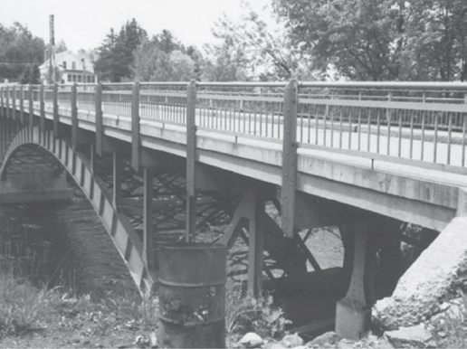
Beginning in spring 2014, the New Hampshire State Historic Preservation Office (SHPO), the Vermont Agency of Transportation, and the New Hampshire and Vermont Divisions of FHWA coordinated the identification and evaluation of historical and archaeological resources with plans to rehabilitate the 1930 steel arch bridge that carries Bridge Street over the Connecticut River between Stewartstown, NH, and Canaan, VT (Figures A-5 and A-6) (NHDOT 2015).

Cultural Resource Findings
The area of potential effects (APE) defined for this project did not include any built environment resources other than the bridge. As part of the project review, the New Hampshire SHPO requested an initial assessment of historic district potential of the neighborhood on the south bank of the river. The New Hampshire Department of Transportation (NHDOT) documented in a memorandum the results of research and fieldwork that found the historic district potential to be low (NHDOT 2015).
Archaeological resources were only identified on the New Hampshire side. NHDOT stipulated to the SHPO that they would install fencing to delineate the area around the location of nineteenth-century covered bridge abutments to avoid impacts.
The Bridge Street Bridge (054/163) was determined eligible for listing in the National Register of Historic Places and recorded in a historic structures report on file at the New Hampshire SHPO. The consulting parties agreed that the following project impacts would not have an adverse effect on the character-defining features of the bridge:
- Replacing the deck.
- Replacing select superstructure steel components (e.g., columns, bracing, floor beams). New attachments would be bolted as opposed to riveted, and, in a few instances, components would be welded where the tools to bolt could not reach.
- Removing and upgrading the rail, which includes the addition of crash-tested bridge rail and ornamental balustrade rail to be attached on the back side of the bridge rail (Figures A-7 and A-8). The rail was designed by NHDOT bridge engineers to be sympathetic to the historic bridge design by keeping the feeling of the vertical balustrades of the original bridge rail but also upgrading its safety standards.
- Painting the ornamental rail green to match the bridge superstructure and leaving the bridge rail galvanized.
- Removing and rebuilding the Vermont abutment.
- Repairing deteriorated areas of the Vermont thrust block.
- Doing minor road and drainage work on the New Hampshire and Vermont approaches.


References
| New Hampshire Department of Transportation (NHDOT) | |
| 2015 | No Adverse Effect Memo: Stewartstown–Canaan 15838. June 22, NHDOT, Concord, NH. On file, NHDOT. |
SR 4001/English Center Suspension Bridge Rehabilitation, Pine Township, Lycoming County, PA
Project Description
Alerted to deficiencies documented in an inspection report, Pennsylvania Department of Transportation (PennDOT) District 3 proposed to rehabilitate the SR 4001/English Center Suspension Bridge in Pine Township, Lycoming County (Figure A-9). The 1891 bridge is listed in the National Register of Historic Places (National Register) under Criterion C for its distinctive

engineering and construction. The purpose of the rehabilitation project was to halt accelerating deterioration, raise the permit weight limit, and provide a safe and reliable crossing of Little Pine Creek that allows for emergency services, passenger vehicles, pedestrians, and bicyclists at all times of the year. As stated in a letter to the Advisory Council on Historic Preservation (ACHP) in November 2018, the deterioration of the bridge had reduced the weight the bridge could legally carry to 3 tons, which made it impossible for the Morris Fire Department, the emergency services provider in the area, to cross the bridge (FHWA-PA 2018).
Following a 2016 rehabilitation study proposing two potential rehabilitation strategies, the project’s consulting parties and members of the public supported Rehabilitation Strategy #1, which would achieve the following goals:
- Preserve character-defining features while replacing inadequate bridge members using in-kind members of similar size and dimensions constructed of steel.
- Retain the visual appearance of the new members (overall size and shape) to be substantially like the members they were replacing.
Additional project goals were as follows:
- Balance all modes of transportation that relate to the recreational tourism industry and growing gas drilling/mining/other industries.
- Consider the unique historic value of the bridge throughout the transportation development process.
- Provide reliable access to the community during construction.
Cultural Resource Findings
The Bridge Street Bridge was listed in the National Register in 1978. PennDOT documented modifications that had been made to the bridge since construction to assess its integrity and determined that “none of the changes/modifications undertaken in the past . . . affected the character-defining features of the bridge such that its status as a[n] NRHP [National Register of Historic Places]-listed resource has been questioned or challenged” (Kuncio 2018:11). The bridge was the only identified historic resource in the area of potential effects (APE). An archaeological survey was conducted on a parcel that was to be disturbed by the project.
As reported in a Determination of Effect Report dated August 1, 2018, PennDOT determined that the rehabilitation project would have No Adverse Effect on the SR 4001/English Center Suspension Bridge, as character-defining features of the bridge would be reused, including one-half of the eyebar suspension chains, the towers that support the chains, all the built-up vertical members, and some of the diagonals (Kuncio 2018). Figure A-10 lists the bridge members to be reused, repaired, and replaced in accordance with Rehabilitation Strategy #1 and identifies the character-defining features of the bridge.
As proposed, half of the wrought-iron eyebar chain members, all the wrought-iron pins, a majority of the diagonal members, and the wrought-iron stiffening girders were to be replaced with new steel members. To meet the Secretary of the Interior’s Standards for Rehabilitation, the following design options were proposed:
- The new eyebar chain members would be like the originals in size, shape, and dimension. The original eyebar members would be placed on the exterior of the chain, and the new members would be placed on the interior. The eyebar chains would also remain pin connected.
- The pins would be new, made of steel, and slightly longer than the current pins.
- The connection details between the stiffening girders and the diagonals would be replicated to match historic appearances in design, shape, dimensions, color, and texture.
- The stiffening girders would be constructed with button-head bolts rather than rivets, as a way of differentiating from the old but retaining the appearance of rivets.
To illustrate these proposed activities, PennDOT contracted with an engineering firm to produce digital depictions of the use of new materials on the bridge and the integration of those materials with the original historic fabric. These illustrations are presented in the 2016 Rehabilitation Study and the 2018 Determination of Effects Report (Kuncio 2018). One example is provided in Figure A-11.


This rehabilitation project engaged several interested consulting parties, including the Pennsylvania State Historic Preservation Office (SHPO), the Historic Bridge Foundation, the Morris Fire Department, and two individuals. Both the Pennsylvania SHPO and the Morris Fire Department returned comments to PennDOT on the finding of No Adverse Effect. The Morris Fire Department objected to the cost of rehabilitating the bridge and requested the construction of a new bridge. The Pennsylvania SHPO disagreed under 36 CFR Part 800.5(c)(2) with the finding, and the dispute was elevated by FHWA to ACHP (FHWA-PA 2018).
SHPO Opinion
In the letter sent to the ACHP, the Pennsylvania SHPO stated that
A significant amount of the material composition of the bridge will be altered by the replacement of wrought iron with high-strength steel. Since the significance of the bridge includes its material composition, the replacement of wrought iron with high-strength steel will diminish the integrity of a character defining feature. (FHWA-PA 2018)
For this reason, the SHPO viewed the rehabilitation as an Adverse Effect to the bridge.
ACHP Response
The ACHP agreed that it was important for the bridge to continue to convey its historic significance and integrity as a functioning transportation structure following the rehabilitation project and stated,
It appears that FHWA has made a reasonable interpretation of the SOI [U.S. Secretary of the Interior] standards and considered alternative[s] that would incorporate historic preservation values into the undertaking’s purpose and need. Accordingly, it is the ACHP’s advisory opinion that FHWA’s finding of “no adverse effect” is appropriate. The ACHP further advises that this finding be made with conditions to ensure the highest standards of rehabilitation are implemented in accordance with the SOI standards. These conditions should be developed in coordination with the SHPO. (ACHP 2018)
References
| ACHP | |
| 2018 | Ref: SR 4001—English Center Bridge; Pennsylvania DOT MPMS 6209. ACHP Office of Federal Agency Programs, Washington, DC, December 13. Accessed July 2023 via Pennsylvania Project Path, https://path.penndot.pa.gov/Documents/25633.pdf. |
| FHWA, Pennsylvania Division (FHWA-PA) | |
| 2018 | Advisory Council on Historic Preservation, Electronic Section 106 Documentation Submittal System (e106) Form: SR4001—English Center Bridge. Accessed July 2023 via PennDOT Project Path, https://path.penndot.gov/Documents/24444.pdf. |
| Kuncio, Gerald M. | |
| 2018 | Determination of Effect: SR 4001/English Center Suspension Bridge Rehabilitation. Prepared for PennDOT Engineering District 3-0 by Skelly and Loy, Inc., Pittsburgh/Harrisburg, PA. Accessed July 2023 via PennDOT Project Path, https://path.penndot.gov/Documents/24105.pdf. |
U.S. Highway 12 Widening Project, Lochsa Ranger Station to Holly Creek Turnout, Idaho County, ID
Project Description
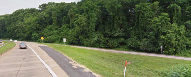
Idaho Transportation Department (ITD) District 2 proposed roadway improvements along U.S. Highway 12 in Idaho County, ID, to increase safety on the narrow, winding route. The proposed project includes the following components:
- Shoulder notch widening of the existing roadway to obtain a 28-foot width.
- Widening of the existing roadway pavement beyond the existing paved surface approximately 1 to 2 feet on each side of the roadway (Figure A-12). Roadway work may extend 7 to 10 feet each side of the roadway, depending on any requirement for guardrails or retaining walls.
- Installation of gabion baskets and retaining walls where needed.
- Addition of rumble strips to the centerline of no-passing zones.
- Application of a warranty sealcoat over the entire surface once the shoulder widening is completed.
- Replacement or rehabilitation of the existing culverts within this section of roadway.
- No use of blasting; however, the use of a rock pick or slick rock removal may occur as needed.
Cultural Resource Findings
ITD completed archaeological and historic architectural resources surveys separate from the identification and evaluation of ethnographic resources, traditional cultural properties (TCPs),

and sacred sites completed by the Nez Perce tribe. ITD identified nine previously recorded resources, including seven archaeological sites and two linear resources (one highway and one trail) within the area of potential effects (APE). On the basis of these project activities, ITD determined that two of the resources eligible for the National Register of Historic Places (National Register) (one archaeological site and U.S. Highway 12) would be affected, but not adversely. All other eligible resources will be avoided and not affected. No newly identified resources were recorded within the APE.
The Nez Perce tribe completed a traditional use study associated with the project that addressed traditional cultural properties. The project area is located within the boundaries of the Lochsa River Corridor TCP. ITD consulted with the Nez Perce tribe to avoid or minimize potential adverse effects on the resource. In an initial disagreement, the tribe believed that any overlap of project activities with the boundary of the TCP would be an Adverse Effect; however, ITD maintained that the proposed changes, namely, 2 feet of widened shoulder, would not touch any features that make the TCP eligible for listing in the National Register and therefore would not qualify as an Adverse Effect.
To address this disagreement, ITD cultural staff led the tribal representatives on an in-person drive through the project area to discuss the extent of the project and the proximity of project activities to the resource. Ultimately ITD reached a finding of No Adverse Effect in agreement with the tribe, with the condition to avoid culturally modified trees in the TCP during construction.
References
| Idaho Transportation Department (ITD) | |
| 2023a | US-12: Lochsa Ranger Station to Holly Creek. ITD, Projects, Boise, ID. Accessed July 2023, https://itdprojects.org/projects/us12rangerstationtoholly/. |
Iowa Highway 31, Little Sioux Riverbank Stabilization, Woodbury County, IA
The following project description and analysis of cultural resource findings of effect are based on a narrative of the project written by Iowa DOT Cultural Resources Team Lead/Tribal Liaison Brennan J. Dolan, titled “Dixon Project Administration, Consultation and Site Preservation” (Dolan 2023) and a phone interview with Mr. Dolan to discuss the project.
Project Description
In 2015, a local maintenance concern emerged regarding the encroachment of the channelized Little Sioux River toward Iowa Highway 31 (Figure A-13). Given the high rate of encroachment, the Iowa DOT had only a couple of years to stabilize the riverbank. An added challenge, and the ultimate driver of the project design, was the known location of the Dixon archaeological site at and between the highway and river intersection. The Iowa DOT landed on the installation of a revetment (riprap) structure for the entire length of the project to stabilize the site to the maximum extent possible. Certain challenges in constructing the revetment in relation to the archaeological site were successfully addressed through consistent and well-intended consultation with tribes, the State Historic Preservation Office (SHPO), and other consulting parties.
Cultural Resource Findings
The Iowa DOT first identified the Dixon Site in the mid-1980s, almost a decade after the Iowa Highway Commission (the precursor to the Iowa DOT) purchased right-of-way from the railroad

that contained the site. By the mid-1990s, the Iowa DOT had considered stabilization of the site using riprap protection. This stabilization work, proposed in 1995, was never completed.
On December 23, 2015, the Iowa DOT held a site visit to review the newly proposed riverbank stabilization. The Iowa DOT district staff met with staff from the Office of Bridges and Structures and the Office of Location and Environment to discuss the project and the location of the site. At that time, the site’s human remains were only observed, and the Office of the State Archaeologist was informed of the remains immediately. Following this site visit, nonfederal consultation was prepared and sent to various tribes and the SHPO on December 31, 2015. A federal nexus for the project occurred later through the need for a U.S. Army Corps of Engineers (USACE) permit. Still, the Iowa DOT focused on the timely consultation with tribes and other consulting parties even prior to the federalization of the project. Select major milestones that occurred under this project are presented in Table A-2. See Dolan (2023) for a full table of consultation milestones.
Several potential impacts to archaeological resources arose during the consultation process, which the Iowa DOT addressed through the following design changes:
- Given the dynamic flow of the Little Sioux River at this location, the distance from the top of the cutbank to the water’s edge could be highly variable, making access for the contractor difficult. Initially, a minimum of five contractor access points were expected to be needed. Access points were reduced to two locations, which reduced the number of potential excavation blocks from seven to four (two key structures and two access points).
Table A-2. Summary of major project consultation milestones for STPN-31-1(41)—2J-47.
| Consultation Event | Party/Parties | Date Issued | Date responded | Notes |
|---|---|---|---|---|
| Early nonfederal consultation | Office of the State Archaeologist | 12/23/2015 | 12/23/2015 | |
| Early nonfederal consultation | Eighteen identified tribes | 12/31/2015 | Various | More information requested; minimize impacts |
| Early nonfederal consultation | Iowa SHPO | 12/31/2015 | ||
| Early nonfederal consultation | Identified tribe | 01/19/2016 | 1/26/2016 | Request for involvement |
| Conference call | All parties | 01/20/2016 | Initial project discussion | |
| Early consultation | By USACE (all parties) | 1/21/2016 | 01/21/2016 | Preapplication |
| On-site review | Identified tribe | 04/05/2016 | ||
| On-site review | Identified tribe | 04/27/2016 | ||
| Conference call | All parties | 06/08/2016 | Discussed draft MOA | |
| Draft MOA and TIP | Seven identified tribes | 06/16/2016 | No comments | |
| Permit application | USACE (all parties) | 08/25/2016 | Begin permit review | |
| MOA filed | USACE (all parties) | 10/13/2016 | MOA signed | |
| On-site project kick-off | All parties | 10/26/2016 | ||
| Data recovery | All parties | 10/2016 to 07/2017 | ||
| Mitigation conference call | All parties | 01/11/2018 | ||
| On-site project close-out | All parties | 04/05/2018 | ||
| Mitigation conference call | All parties | 07/23/2018 | Discuss second option |
Source: Adapted from Dolan 2023:60.
Note: MOA = memorandum of agreement; TIP = tribal involvement plan.
- Given the desired angle of the revetment structure, a project like this would typically require the removal of the top few feet of the cutbank. Through discussion of the importance of not affecting the cutbank, the revetment structure was moved slightly farther into the water so that the desired angle of the revetment could be achieved without having to trim the top of the cutbank and affect a much greater amount of the Dixon Site.
Project Outcomes
The Iowa DOT entered into a memorandum of agreement (MOA) with seven identified tribes and USACE and developed management plans for the future preservation of the Dixon Site and tribal engagement (Table A-3). Once the project was let and throughout the construction process, extensive coordination occurred between all parties, especially with participating tribes and nations as well as the contractor. Multiple on-site meetings occurred at the request of the contractor just prior to the start of construction, to ensure and reassure all parties of project restrictions. In addition, participating tribes and nations maintained a regular presence at the site throughout the life of the project. A key to the success of this project was the regular, clear, and focused communication.
Table A-3. List of tools developed for management of the Dixon site.
| Tool | Date | Comments |
|---|---|---|
| Project MOA | Signed October 12, 2016 | Use of anticipated discoveries clause. |
| Tribal Involvement Plan (TIP) | Drafted June 2016 | Provides framework for tribal involvement geared toward flexibility. |
| Dixon Site entered into the Iowa DOT’s draft historic sites inventory | 2013 | — |
| Dixon Site Management Plan | October 2018 | The Dixon Site was classified for management purposes with the highest level of preservation and site review. This means that the following activities were not permitted: ground disturbance, utility placement, additional or new access, tree removal, landscaping, and spraying. |
In addition, public education efforts were carried out by a collective group of stakeholders to create a series of presentations, informative videos, and other material. Some of these materials can be found at “Excellence in Archaeology and Historic Preservation Award; Dixon Site Riverbank Stabilization Project,” https://youtu.be/FqTEK328ans.
References
| Dolan, Brennan J. | |
| 2023 | Dixon Project Administration, Consultation and Site Preservation. Journal of the Iowa Archaeological Society 70:58–64. |
Widen I-285 Top End Express Lanes and Flyover Ramps, Cobb, Fulton, and DeKalb Counties, GA
Project Description
In 2021, the Georgia Department of Transportation (GDOT) proposed the construction of express lanes in each direction along 18 miles of I-285 just south of Paces Ferry Road to Henderson Road, along 3.5 miles of SR 400, and along 1 mile of I-85 from Chamblee Tucker Road to a point just north of Pleasantdale Road. The purpose of the project is to improve mobility, provide more reliable trip times, and offer a mobility choice to motorists traveling through the metro Atlanta region. The proposed project includes two new barrier-separated express lanes in both directions of I-285 and SR 400 alongside the existing general-purpose lanes, elevated and at grade.
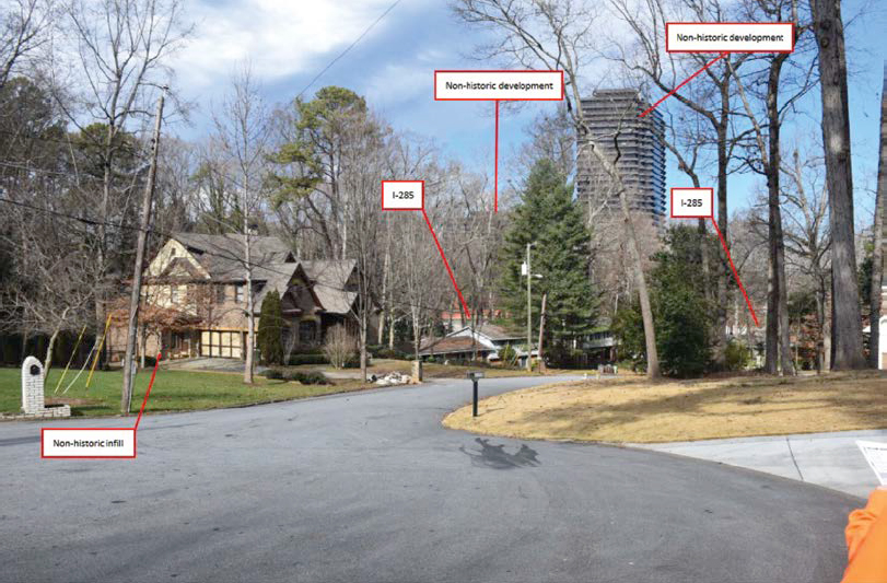
Cultural Resource Findings
GDOT identified five historic properties within the APE, including the Oak Forest Hills Historic District, which has visibility of the existing Interstate. GDOT determined the project would have No Adverse Effect on historic properties. To support this finding, GDOT provided the Georgia Historic Preservation Division (Georgia SHPO) with photographic simulations of the proposed express lanes from within the Oak Forest Hills Historic District as a means of analyzing the potential for visual impacts on the district.
In a letter dated January 8, 2021, the Georgia SHPO concurred with a finding of No Adverse Effect for all properties except the Oak Forest Hills Historic District without further information. Concerns were stated that “while the proposed noise walls and elevated express lanes will primarily be visible from the rear yards of the houses that border the I-285 corridor, it appears from the submitted photographic simulations that the proposed I-285 infrastructure will be significantly visible from the houses within the district’s interior, due to a lack of significant mature vegetation to adequately screen the interior of the district from the proposed project” (Georgia SHPO 2021). Although some simulations were provided for review, the Georgia SHPO felt it was unclear whether they represented typical visibility of the highway in the district or whether the simulated visibility was restrictive to those vantage points.
In response to the Georgia SHPO’s concern regarding the accuracy of the visual simulations of the project and the potential visual impacts of the project on the Oak Forest Hills Historic District, GDOT conducted additional field survey and photographic simulations to provide a more accurate representation of the project’s potential effects on the district’s interior visual conditions (Figures A-14 and A-15) (VHB 2021). Photographs from additional vantage points within the district and photographic simulation of the proposed express lanes from the interior of the district resulted in an updated assessment of effects:
Although new express lanes bridges would be constructed within the viewshed, the visual character of the district would not be altered. I-285 is already highly visible during the winter months, particularly along the visual axis created by the interior roadways. The additional bridges proposed as part of the express lanes are not expected to further alter this intrusion caused by I-285. The proposed project would not introduce visual elements that diminish the integrity of the district’s significant historic features, as I-285 is already a component of the visual character. (GDOT 2021)
The additional simulations provided SHPO with enough further information to agree with a No Adverse Effect finding for the project.

References
| Georgia Department of Transportation (GDOT) | |
| 2021 | Letter from Eric Duff, GDOT State Environmental Administrator, to Dr. David Crass, Georgia Deputy SHPO, Regarding Section 106 Compliance for GDOT Project NHS00-0001-00(758). Original on file at the Georgia DOT office in Atlanta, GA. February 9. |
| Georgia Historic Preservation Division (Georgia SHPO) | |
| 2021 | Environmental Review Form. Georgia Department of Community Affairs, Georgia State Historic Preservation Office, Atlanta, GA. Accessed December 2022, https://www.dca.ga.gov/node/6684. |
| VHB | |
| 2021 | Subject: GDOT Project I-285 Top End Express Lanes, DeKalb County et al.; Visual Effects Supplemental Memorandum. February 1, 2021. On file, Georgia Department of Transportation, Atlanta, GA. |
I-695 (Baltimore Beltway) I-70 to MD-43 (White Marsh Boulevard) Transportation Systems Management and Operations, Baltimore County, MD
Project Description
The Maryland Department of Transportation (MDOT) State Highway Administration (SHA) proposed installation of Transportation Systems Management and Operations (TSMO) to reduce congestion along the west and north sides of the Baltimore Beltway, from the I-70 interchange to MD-43 (White Marsh Boulevard) in Baltimore County, MD. Among other purposes, the project’s intent, in addition to reducing congestion, includes improving mobility, providing a safer corridor, and making improvements that reduce operations and maintenance activities
and adapt to future technological advancements in transportation (MDOT-SHA 2024). The proposed project includes the following components:
- TSMO strategies.
- Improvements to capacity by converting portions of the existing median shoulder to a toll-free travel lane during the morning and evening rush hours and employing
- Potential active traffic management and ramp metering.
- Installation of gantries (minimal traffic control devices) to add capacity on existing pavement.
- Use of design–build by SHA as the project delivery method.
Cultural Resource Findings
To address potential effects on historic resources as a result of the project, MDOT cultural resources staff used an existing programmatic agreement (PA) that covered large design–build projects over a large area of the Maryland Beltway as a template for a project-specific PA. The project PA included work within the limits of the beltway immediately adjacent to the Hampton Mansion National Historic Site (Figure A-16).
Typically, for a project of this nature, all properties of historic age along the route would need to be surveyed and evaluated for inclusion in the National Register of Historic Places. As an alternative, for this project, SHA identified the known historic properties in the project vicinity and, through consultation with SHPO, agreed that for most of the historic properties, if certain types of project activities were kept within the existing pavement, there would be no potential for impacts.
Following the identification of known historic resources in the project vicinity and by way of the Section 106 process, concerns arose regarding only one historic resource: the Hampton National Historic Site (NHS). A closed-circuit television camera was to be installed within the viewshed of the site. The National Park Service (NPS) owns and manages the Hampton NHS,
which is interpreted as possibly being the largest private home in America by 1790. SHA included provisional language in the PA indicating SHA’s intentions to notify NPS when the design had been completed to a point that showed consistency with the exempt activities identified earlier in the Section 106 process. Although SHA felt it had clearly explained that the activities near the Hampton Mansion were not different from those in other areas along the beltway, which were agreed not to have potential effects on historic properties, NPS and the SHPO felt that a lack of sufficient information left uncertainty concerning the potential visual effects on the mansion.
As a result of this disagreement, SHA hosted a site visit with the Section 106 consulting parties to discuss the project, and all parties were able to come to a resolution without needing to elevate the dispute to FHWA or the Advisory Council on Historic Preservation (ACHP). The site visit appeared to address the following challenges:
- The site visit consultation helped to clarify each perspective.
- From the DOT perspective, the installation of the traffic-monitoring device within the highway right-of-way was a normal highway pertinence and most often resulted in a finding of No Historic Properties Effected, no matter where it was located. SHA felt that, because of the nature of the project activity and the fact that the Hampton Mansion already had a view of the highway, the agency then put in a position of minimizing an effect that from the DOT perspective was very clearly a No Effect.
- From the NPS perspective, the NHS was a special area to which normal interpretations of effects do not necessarily apply and ran the risk of setting a precedent for more encroachment.
- From the SHPO perspective, there was a lack of sufficient project information to feel comfortable with the potential visual effects.
- By meeting face to face with all consulting parties, including the FHWA engineer, the Hampton Mansion Superintendent, and NPS northeast regional staff, NPS could better articulate its concerns to SHA.
- As a result, SHA went back to its engineers and changed the location of the camera to outside the core viewshed as identified by NPS.
This project inspired a question from SHA: When does encroachment on an already altered setting become an Adverse Effect?
References
| Maryland Department of Transportation (MDOT), State Highway Administration (SHA) | |
| 2024 | I-695 (Baltimore Beltway) I-70 to MD-43 (White Marsh Boulevard) TSMO (Transportation Systems Management and Operations), Baltimore County. State Highway Administration, Crownsville, MD. Accessed 2024, https://mdot-sha-i695-i70-to-md43-ba006213-maryland.hub.arcgis.com/. |
| National Park Service (NPS) | |
| 2023 | Hampton National Historic Site, Maryland: Mansion Side. U.S. Department of the Interior, Washington, DC. Accessed July 2023, https://www.nps.gov/hamp/learn/historyculture/mansion-side.htm. |
Route 16 Improvements, Ossipee 41251, Ossipee, Carroll County, NH
Project Description
The New Hampshire DOT (NHDOT) proposed pavement rehabilitation and drainage upgrades to NH Route 16 from Polly’s Crossing on Route 16 to the intersection with Route 16B in Ossipee, NH (Figure A-17). The proposed project includes the following components:
- Full box reconstruction, including removal of the 20-foot-wide concrete slab underneath the existing roadway;

- Construction of two 12-foot travel lanes with 4-foot paved shoulders and a 6-foot ditch line where needed;
- Conversion of a truck lane into a two-way left-turn lane in response to safety concerns;
- In the area of the Bertwell Cemetery (not eligible for the National Register of Historic Places), temporary widening of the roadway to accommodate traffic during construction, which will require tree clearing and stone lining of the embankment; and
- Permanent easement from the historic property (needed for continued drainage access) and resetting of a stone wall remnant.
Cultural Resource Findings
Improvements to this section of Route 16 were first proposed in 2001 as part of improvements to a larger corridor. At that time NHDOT inventoried historic properties in the larger project area by means of a project area form and initiated consultation with SHPO. NHDOT shelved the project and then reactivated it around 2016, broken into smaller sections, one being from Polly’s Crossing to the Route 16B intersection. The reactivated project was treated as a new project with a new project number and updated Section 106 consultation.
Much of the identification phase of the new consultation was satisfied by the surveys of resources completed in 2001; however, given the long period of time between undertakings, the project area form was updated in 2020 and new or updated inventory forms were completed for six resources within the area of potential effects (APE), including a farmstead eligible under Criteria A and C.
In addition, three stone walls identified as eligible for reconstruction as part of the NHDOT Stone Wall Policy would be affected by the project. The NHDOT Stone Wall Policy Guidelines (NHDOT 2017) is a cultural and environmental planning document used to ensure the effective evaluation and management of stone walls in New Hampshire that may be affected by a transportation undertaking. In 1990, NHDOT first implemented the State of New Hampshire Stone Wall Reconstruction Policy to address the “concern over the loss of the character associated with rural roads and in particular the resource represented by stone walls” (NHDOT 2017:1). The updated 2017 policy retains components of the 1990 policy, notably, the process of a coordinated review by NHDOT, the New Hampshire State Historic Preservation Office (SHPO), and FHWA on the findings and proposed actions for avoidance, preservation, deconstruction, or relocation of any impacts on stone walls in a project area. Today, from the SHPO perspective, although the policy often matches up with historic evaluations of stone walls, it does not account
Table A-4. Evaluation of Adverse Effects on the historic property.
| Example of Adverse Effects, pursuant to 36 CFR Part 800.5(a)(2) | Evaluation |
|---|---|
| (iv) change of the character of the property’s use or of physical features within the property’s setting that contribute to its historic features; | A rock cluster and degraded stone wall that runs at a skewed perpendicular angle to Route 16 east of Thissell Road will be impacted, and 20 feet of stone will be removed and reset, at the landowners’ request. A drainage easement (400 square feet of property) will be permanently acquired. Much of this area is already serving for drainage, and the property owner believes this drainage improvement will alleviate seasonal drainage problems on Thissell Road. |
| Recommended finding (No Adverse Effect or Adverse Effect) | No Adverse Effect On the basis of the limited impacts on the property at 2 Thissell Road, there will be no adverse effect, as the proposed activities will not significantly change the visual appearance at this intersection. The rock cluster and degraded stone wall alignment that will be reset did not qualify for stone wall reconstruction, and the drainage easement and tree clearing associated with the intersection reconstruction will be minimal in visual change. |
for the potential contributing status of the wall to a resource. Therefore, if a stone wall does not meet the policy rating for reconstruction but does contribute to a historic property, there can be a conflict in assessing the effects on the wall.
This project involved robust consultation with consulting parties at the identification step of the Section 106 process. One consulting party communicated well with NHDOT and the New Hampshire SHPO and provided information on cemeteries near the project that otherwise would likely have been left unidentified. SHPO staff and DOT cultural staff walked the property of the cemetery with the consulting party and were informed of several unmarked graves in the vicinity. DOT and SHPO archaeologists accurately delineated the cemetery to determine its exact proximity to the project APE.
NHDOT evaluated the effects on the identified historic property shown in Table A-4 (NHDOT 2022a). NHDOT and the SHPO came to an agreement of No Adverse Effect from the undertaking, given the following details about the project activities and commitments (NHDOT 2022b):
- Four hundred square feet of impacts was identified.
- The impacts were considered limited, as the viewshed from the historic property would not change, in that tree removal would be kept to a minimum and the appearance of the reconstructed intersection in view of the historic property would remain relatively the same.
- The project adhered to the New Hampshire Stone Wall Policy.
- There would be monitoring in the vicinity of burials if excavation was needed within 25 feet of the cemetery.
- It was feasible to reconstruct and relocate two of the stone walls outside of the right-of-way and to reconstruct one of the stone walls in the same location.
References
| New Hampshire Department of Transportation (NHDOT) | |
| 2017 | NHDOT Stone Wall Policy Guidelines. NHDOT, Concord, NH. Accessed 2024, https://www.dot.nh.gov/documents/nhdot-stone-wall-policy-guidelines. |
| 2022a | Ossipee 41251, RPR #12145 Assessment of Effect Tables. NHDOT, Concord, NH. On file, NHDOT. |
| 2022b | No Adverse Effect Memo: Ossipee X-A004(573), 41251. NHDOT, Concord, NH. On file, NHDOT. |
U.S.-6 (6th Avenue) and CO-121 (Wadsworth Boulevard) Phase 3 Early Action Auxiliary Lane Project, Lakewood, Jefferson County, CO
Project Description
This project is part of a larger effort, broken into three phases, to reconstruct the U.S.-6 and Wadsworth Boulevard interchange. The third phase of the project focuses on the improvement of vehicular mobility, pedestrian improvements, and noise abatement walls within a portion of the interchange. The proposed Phase 3 of the project includes the following components.
- Addition of a new eastbound auxiliary lane on U.S.-6;
- Realignment of a portion of the eastbound frontage road, to include the addition of curb and gutter and new driveway curb cuts to accommodate existing driveways;
- Filling in a small sidewalk gap by adding a new 10-foot-wide sidewalk section with curb ramps;
- Installation of rapid-flashing beacons at five new pedestrian sidewalk crossings;
- Drainage and water quality improvements; and
- New noise walls along the frontage road.
Cultural Resource Findings
The area of potential effects (APE) defined for this project includes a portion of the Meadowlark Hills Historic District eligible for the National Register of Historic Places (National Register), one newly identified commercial resource eligible for the National Register, and two nonsupporting segments of eligible linear resources. The Colorado Department of Transportation (CDOT) found that the project would cause No Adverse Effect to the commercial resource or the two nonsupporting segments of the eligible linear resources, as no changes, acquisitions, or easements were required from the resources and any visual effects would not diminish the ability of the properties to convey their historic significance. The APE extends approximately four residential lots into the Meadowlark Hills Historic District, to account for potential noise and visual effects caused by traffic on U.S.-6 and the proposed construction of a noise wall to decrease the noise level for the neighborhood. To assess the potential effects on this resource and others within 500 feet of U.S.-6 between Garrison Street and Wadsworth Boulevard, CDOT conducted a noise analysis to study current and future noise impacts.
Results of the Noise Analysis and Assessment of Effect
CDOT concluded through the noise analysis that the noise levels from U.S.-6 were currently at or exceeded the 66-dBA level at the loudest hour of the day for 42 residences within the historic district. This level of noise constitutes a noise impact under the CDOT Noise Analysis and Abatement Guidelines (CDOT 2020) and meets the threshold for noise mitigation for residential properties. To mitigate the anticipated rise in noise levels, Colorado proposed two noise walls along the south side of U.S.-6, with one wall extending across the north side of the Meadowlark Hills Historic District. The expected noise reduction as a result of the noise walls would bring levels below the allowable threshold for residential properties. Noise wall design concepts have been developed in consultation with neighborhood input and simulated to provide an image with which to assess the potential visual effects of the wall (Figure A-18).
On the basis of the anticipated reduction of noise and visual impacts owing to the proposed noise wall and the compatible and unobtrusive design of the walls in the historic district, CDOT has made a determination of No Adverse Effect for the Meadowlark Hills historic district:
The project will have no direct impacts to the neighborhood’s layout or street access, or to any properties within the historic district. The neighborhood will continue to have direct access to the US 6 south frontage road as it does now. The new noise wall will minimally change the view from houses within the historic
district located directly south of US 6 and the frontage road given that the houses face east-west, and that US 6 and the proposed noise wall are oriented in the east-west direction. In contrast, the new sound barrier will dramatically improve noise levels within the neighborhood and provide a much-needed visual and noise buffer separating the historic neighborhood from busy traffic on US 6. While the new noise wall will minimally change the visual relationship of the neighborhood to US 6, the highway has been widened and has dramatically changed over the years causing a significant change to that relationship already. The proposed improvements will not affect the ability of the historic district to convey its significance as a postwar subdivision in Lakewood with architectural significance. (CDOT 2023:11)
References
| Colorado Department of Transportation (CDOT) | |
| 2020 | CDOT Noise Analysis & Abatement Guidelines. CDOT, Denver, CO. https://www.codot.gov/programs/environmental/noise/regulations-guidelines-policies. |
| 2023 | Re: Section 106 Determination of Eligibility and Effects, US 6 (6th Avenue) and CO-121 (Wadsworth Boulevard) Phase 3 Early Action Auxiliary Lane Project, Lakewood, Jefferson County. CDOT, Denver, CO, January 23. |
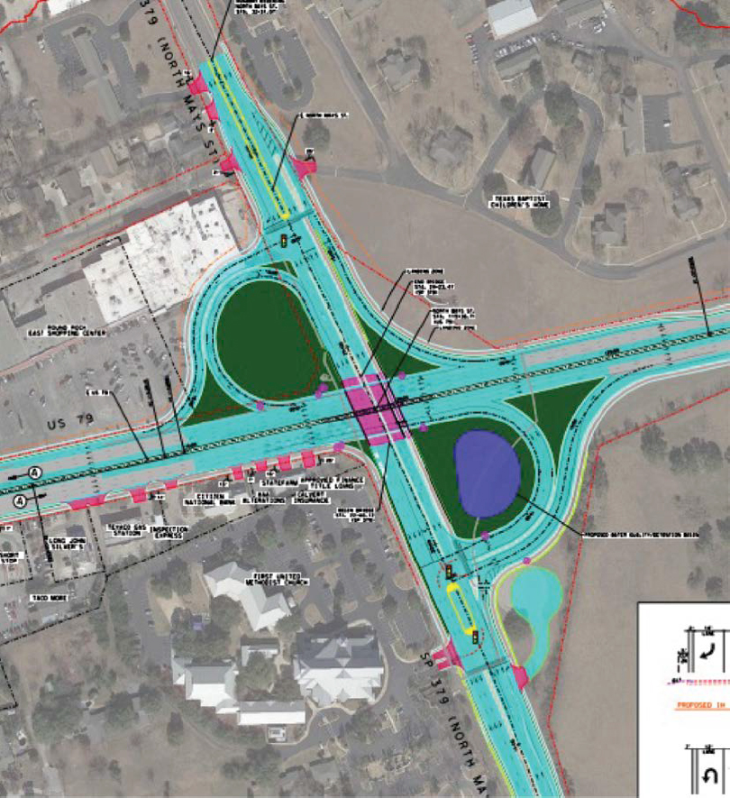
U.S.-79 from I-35 to East of FM 1460, Widening and Improvements, Round Rock, Williamson County, TX
Project Description
The Texas Department of Transportation (TxDOT), Austin District, proposed improvements to U.S.-79 from I-35 to east of FM-1460 within the City of Round Rock in Williamson County, TX. The purpose of the project was to improve safety and mobility and accommodate future population growth and land use development in the area. The proposed project includes the following improvements:
- Widening the existing U.S.-79 roadway to add a third travel lane in each direction;
- Installing a raised median for safety;

- Constructing an underpass at the intersection of U.S.-79 and Mays Street, an overpass at intersection of U.S.-79 and FM 1460, and altering the U.S.-79/I-35 intersection;
- Modifying driveways and access points to improve safety and traffic flow; and
- Installing shared-use paths on both sides of U.S.-79 to provide improved accommodation of pedestrians and bicycles.
Cultural Resource Findings
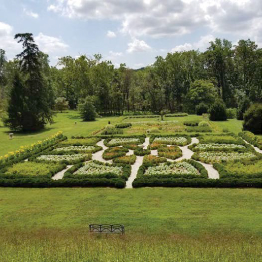
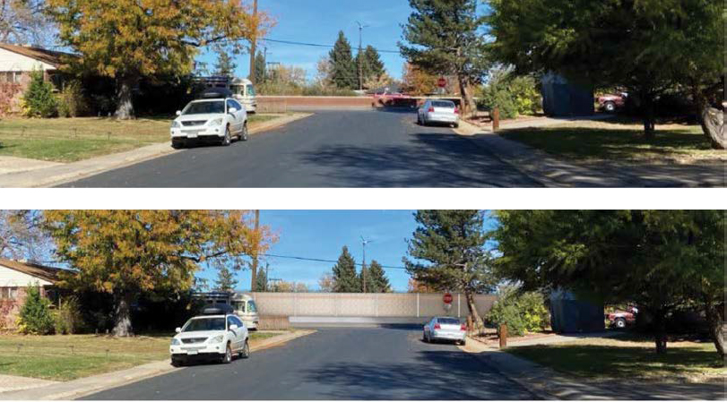
Through an architectural survey, TxDOT identified four historic properties within the project area of potential effect (APE): three historic homes and one Texas Historical Marker (Figure A-19). As planned, TxDOT proposed to acquire no more than 0.55 acre from each of the three residential properties. Originally, TxDOT proposed construction of a clover-leaf interchange on the front lawn of the Texas Baptist Children’s Home, which is eligible for the National Register of Historic Places; however, through consultation, plans were redesigned to relocate the cloverleaf to the opposite side of the road from the children’s home, thereby minimizing any effects on the historic property (Figures A-20 and A-21). Additional conditions were stipulated by the Texas State Historic Preservation Office (SHPO) to reach a finding of No Adverse Effect:

- When available, TxDOT will submit a scope of work and plans for the relocation of the historic walls at the Texas Baptist Children’s Home to the SHPO for review. The plans must meet the Secretary of the Interior’s Standards for Rehabilitation.
- When available, TxDOT will submit a scope of work and plans for the relocation of the four historic driveway entrance pillars to the SHPO for review. The plans must meet the Secretary of the Interior’s Standards for Rehabilitation.
References
| Texas Department of Transportation (TxDOT) | |
| 2018 | Documentation of Public Meeting: US 79, CSL: 0204-01-063. A. Comment/Response Matrix. TxDOT, Austin, TX. Accessed July 2023, https://ftp.txdot.gov/pub/txdot/get-involved/aus/us-79-i-35-fm1460/082318-documentation.pdf. |
| 2022 | Final Environmental Assessment: U.S. Highway 79 (CSJ Number 0204-01-063). TxDOT, Austin, TX. Accessed July 2023, https://ftp.txdot.gov/pub/txdot/get-involved/aus/us-79-i-35-fm1460/080422-final-ea.pdf. |
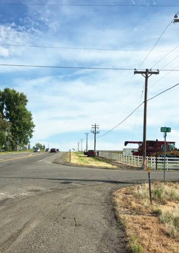
U.S.-93 Improvements Project, Jerome County, ID
Project Description
The Idaho Transportation Department (ITD) proposed the construction of a four-lane roadway (U.S.-93) divided by a median for 2.255 miles in Jerome County, ID. The current highway is two lanes, and the existing lanes will continue to be used by the traveling public (Figure A-22).
Cultural Resource Findings
U.S.-93 is eligible for the National Register of Historic Places under Criterion A for its association with transportation, particularly in providing a rural transportation route between small and medium-sized towns with industrial and recreational areas. A 1950s portion of the road, built as a bypass, is considered as contributing to the overall eligibility of the roadway.
ITD determined there would be No Adverse Effect to U.S.-93 because, despite the roadway’s material changes, it has maintained its alignment and its ability to convey traffic in a rural area. Because the proposed project would not directly change the alignment, design, or location of the historic roadway, ITD believes that any diminishment of the roadway’s integrity would be unlikely and that the roadway would still convey its historic significance.
The Idaho State Historic Preservation Office (SHPO) objected to the finding of No Adverse Effect, stating that the introduction of a median and an additional two lanes of traffic would create a dual carriageway or divided highway and that the proposed project would affect the segment’s integrity of feeling, design, and setting, as the SHPO believed the open expanses that surround the roadway contribute to its setting and feeling (ACHP 2020).
This dispute was brought formally for comment to ACHP in 2020. ACHP’s response concluded that the dispute on the assessment of effect stemmed from a disagreement regarding the
aspects of U.S.-93’s design and setting that might be affected by the undertaking. ACHP stated that “SHPO believes that the setting is a central element of integrity, while FHWA, based on the property’s significance, has placed a higher emphasis on the property’s integrity of location” (ACHP 2020:1). Given the project as presented, ACHP acknowledged that ITD made a reasonable interpretation of the application of the criteria of adverse effect and that the finding of No Adverse Effect was appropriate. ACHP cited the following project elements to demonstrate that opinion:
- ITD chose design measures to minimize the impact of the undertaking on the historic property to ensure U.S.-93’s continued ability to convey its significance.
- A median planted with native grasses will blend into the setting of U.S.-93.
- The new transportation facility will be adjacent to the historic roadway, rather than changing the design of the historic property.
ITD is in the process of completing a historic context for historic roads in Idaho that will include an identification survey. This will be an invaluable tool for assessing the effects of future undertakings and will assist in ensuring that SHPO, DOT, and the FHWA make mutually agreeable determinations regarding the significance and integrity of properties throughout the state.
References
| Advisory Council on Historic Preservation (ACHP) | |
| 2020 | Ref: US-93 Improvement Project. ACHP, Office of Federal Agency Programs, Washington, DC, June 11. On file, ACHP, Washington, DC. |
| Idaho Transportation Department (ITD) | |
| 2023 | US-93, 300 South Road.ITD, Projects. Boise, ID. Accessed July 2023, https://itdprojects.org/projects/us-93-300-south-road/. |
This page intentionally left blank.
Abbreviations and acronyms used without definitions in TRB publications:
| A4A | Airlines for America |
| AAAE | American Association of Airport Executives |
| AASHO | American Association of State Highway Officials |
| AASHTO | American Association of State Highway and Transportation Officials |
| ACI–NA | Airports Council International–North America |
| ACRP | Airport Cooperative Research Program |
| ADA | Americans with Disabilities Act |
| APTA | American Public Transportation Association |
| ASCE | American Society of Civil Engineers |
| ASME | American Society of Mechanical Engineers |
| ASTM | American Society for Testing and Materials |
| ATA | American Trucking Associations |
| CTAA | Community Transportation Association of America |
| CTBSSP | Commercial Truck and Bus Safety Synthesis Program |
| DHS | Department of Homeland Security |
| DOE | Department of Energy |
| EPA | Environmental Protection Agency |
| FAA | Federal Aviation Administration |
| FAST | Fixing America’s Surface Transportation Act (2015) |
| FHWA | Federal Highway Administration |
| FMCSA | Federal Motor Carrier Safety Administration |
| FRA | Federal Railroad Administration |
| FTA | Federal Transit Administration |
| GHSA | Governors Highway Safety Association |
| HMCRP | Hazardous Materials Cooperative Research Program |
| IEEE | Institute of Electrical and Electronics Engineers |
| ISTEA | Intermodal Surface Transportation Efficiency Act of 1991 |
| ITE | Institute of Transportation Engineers |
| MAP-21 | Moving Ahead for Progress in the 21st Century Act (2012) |
| NASA | National Aeronautics and Space Administration |
| NASAO | National Association of State Aviation Officials |
| NCFRP | National Cooperative Freight Research Program |
| NCHRP | National Cooperative Highway Research Program |
| NHTSA | National Highway Traffic Safety Administration |
| NTSB | National Transportation Safety Board |
| PHMSA | Pipeline and Hazardous Materials Safety Administration |
| RITA | Research and Innovative Technology Administration |
| SAE | Society of Automotive Engineers |
| SAFETEA-LU | Safe, Accountable, Flexible, Efficient Transportation Equity Act: A Legacy for Users (2005) |
| TCRP | Transit Cooperative Research Program |
| TEA-21 | Transportation Equity Act for the 21st Century (1998) |
| TRB | Transportation Research Board |
| TSA | Transportation Security Administration |
| U.S. DOT | United States Department of Transportation |


