Tools and Technology for Roadside Vegetation Asset Management: A Guide (2025)
Chapter: 2 Case Study Summaries

CHAPTER 2
Case Study Summaries
2.1 Introduction
The research team developed case studies to provide examples of state DOTs at different stages of RVAM development. The research team focused on state DOTs that have RVAM plans and are using tools and technology to assist in achieving their RVAM goals. Five state DOTs served as case studies during the fall of 2023: Caltrans, ODOT, TDOT, WSDOT, and Wisconsin Department of Transportation (WisDOT). These five state DOTs were selected because each had an RVAM plan and tools and technology that the research team wished to highlight. TDOT and WisDOT are in the early stages of RVAM development, Caltrans is at a mid-stage of RVAM development, and ODOT and WSDOT are in late-stage development of their RVAM plans. The full case studies are in Appendix B.
Each state has a different organizational structure. Caltrans and ODOT each have a central office that oversees districts, with counties as the smallest management structure. TDOT is similar with a central office, followed by regions, districts, and then counties. WisDOT has a central office followed by regions and then counties. WSDOT has a central office followed by regions and then maintenance units. The definition of a region or other organizational structural unit differs among states, so in this chapter, the language matches the language of the case study state. Otherwise, generic language is used where the lowest level of organization is referred to as local staff, and the next level up is referred to as a district.
2.2 California Department of Transportation
Caltrans has a hybrid organizational structure where the central headquarters establishes statewide goals and performance targets, issues funding, and tracks the progress of counties and districts, while district staff identify landscape rehabilitation project locations and detailed scopes of work. Each district has a trained staff member who helps develop scopes of work. Partially because of union contracts, nearly all work is completed in house—construction-based seeding is completed by contractors, and 10% of construction project design is completed through contractors. Caltrans has district-based staff in the Division of Design who help develop the State Highway System Management Plans (SHSMPs) and update the district-level integrated vegetation management plans (IVMPs) annually. Caltrans goes beyond FHWA requirements and has incorporated culvert maintenance into the state TAMP. Software and hardware systems that Caltrans uses for planning and tracking include
- The Integrated Maintenance Management System (IMMS). This proprietary software tracks costs and tasks.
- Commercial off-the-shelf (COTS) software and proprietary configurations of commercially available software (PCCA software) for mapping [e.g., Environmental Systems Research Institute Inc. (Esri)]. These enable information from IMMS to be imported and for data fields to be added as the IVMPs progress over time.
- Light Detection and Ranging (LiDAR). This is used to evaluate areas following wildfires and identify blocked culverts, dead trees, and damaged roads.
- Tablets. These are made available to some “water managers” and field staff managers for tracking assets and asset condition ratings.
2.3 Ohio Department of Transportation
ODOT operates with a hybrid organizational structure where the central headquarters provides guidance to ODOTʼs county- and district-level garages about available tools and training on how to use them. ODOT provides districts and counties with lists of vendors they can contract with and order equipment from, allowing local staff to develop vegetation management plans according to their needs. Although vegetation maintenance guidance is provided through the 2019 Guidelines for Mowing Reduction Outside Clear Zones for Compliance with the Monarch CCAA and the Maintenance Operations Manual, each county determines their vegetation management plan for the year. The central office also provides staff with a list of approved herbicides to use. The list details which species each herbicide controls. The percentage of in-house maintenance work differs among counties because equipment, experience, and the number of licensed staff varies. Statewide, work completed by in-house crews consists of 90% of mowing, 10% of herbicide application, 25% of all overseeding of wetland sites and seeding of pollinator habitat sites, and 100% of monitoring of seeded areas. ODOTʼs environmental division completes 100% of the wetland delineations and tracking of threatened and endangered (T&E) species. All other tasks are completed by contractors, including postconstruction seeding. Some of the systems ODOT uses include
- The Enterprise Information Management System (EIMS). This proprietary software tracks labor, equipment use, and work completed by each staff member. Reports can be exported directly from this system or to other commercially available software systems ODOT uses to create more nuanced reports.
- ODOTʼs Bi-Weekly Collector App and the Transportation Information Mapping System (TIMS), developed by IT staff in conjunction with commercially available mapping software.
- The Bi-Weekly Collector App is a geodatabase available on tablets and management staffʼs cellular phones. Each county manager or their designate is responsible for driving all ODOT-maintained roads within the county every 2 weeks to (1) identify structural and vegetation maintenance needs across the county and (2) enter work orders into the system.
- TIMS is used to track equipment inventories, project statuses and costs, asset ratings, and more.
- Tablets. ODOT provides each county-level garage with three to four tablets for local staff use. County-level garage managers determine who has access to these tablets. Most team leaders can access tablets regularly, but all staff have log-in credentials if they need to access the system.
- COTS software and PCCA software for mapping (e.g., through Esri). This allows for multiple proprietary systems to be designed. The information is pulled from these PCCA software systems into an overall map for use by central office staff.
2.4 Tennessee Department of Transportation
TDOT operates with a hybrid centralized and decentralized organizational structure with four regions separated into three districts each. The central office provides minimum maintenance requirements through the IVMP and provides statewide contracts for all tools and technology. The IVMP was developed in 2016 with little staff resistance; TDOT staff ascribed this to the IVMP providing general guidance rather than strict requirements. District staff develop vegetation management plans that follow state-provided guidance and are further detailed according to their needs. TDOT staff complete 20% of vegetation mowbacks (mowing to the edge of the right-of-way), 90% of postconstruction inspections, 100% of herbicide applications, and 100% of brush clearing in house. TDOT staff assist contractors with federal natural disaster cleanup.
The Tennessee Department of Environment and Conservation (TDEC) completes 100% of wetland delineations and tracking of T&E species in the state and provides the information to TDOT. Some of TDOTʼs software and hardware systems include
- The Maintenance Management System (MMS). This proprietary management system is used to enter and track maintenance requests, staff time, and maintenance task statuses. TDOT is preparing to replace this system due to age.
- Street-level, high-resolution imagery (collected through contractors such as Cyclomedia) of all trees within 15 feet of state-maintained roads once per year. The trees are geolocated and analyzed using both LiDAR point clouds and high-resolution imagery using vehicles fitted with 360-degree cameras to capture images that are then interpreted using artificial intelligence (AI) software.
- COTS mapping software (e.g., Esri) is used to overlay information collected from the street-level, high-resolution imagery to identify locations with tree maintenance or removal needs.
2.5 Washington State Department of Transportation
WSDOT has a centralized organizational structure with statewide management coordination of 24 maintenance areas within six regions. The principal landscape architect from the central office works with local staff to develop an Integrated Roadside Vegetation Management (IRVM) plan for each maintenance area annually. WSDOT is going beyond FHWA requirements and incorporating roadside land use, culverts, signs, roadway delineation, and chronic environmental deficiencies into the state TAMP. Given union contracts, WSDOT completes 100% of RVAM work in-house following construction and a predetermined plant establishment period. WSDOTʼs software and hardware systems include
- DOT Time. WSDOTʼs proprietary management software tracks labor and equipment costs.
- Financial Reporting System (FIRS). WSDOTʼs proprietary business analytics platform extracts data from DOT Time to track labor, equipment costs, asset conditions, and equipment use.
- HATS. This PCCA software, based on a mapping system (e.g., Esri), maps and tracks planned and completed work tasks. Like ODOTʼs Bi-Weekly Collector App, all designated assets can be tracked within this system, and it is supported by five staff members statewide.
- Tablets. Every local staff member is assigned a tablet to access DOT Time and HATS to track staff productivity, planned tasks, and acreage of work completed. This information is funneled into FIRS to develop budgets for each maintenance unit.
2.6 Wisconsin Department of Transportation
WisDOT has a unique organizational structure. The Division of Transportation System Development (DTSD) oversees development, maintenance, and operational functions related to the state highway system. WisDOTʼs five regions, following guidance from the central office, (1) provide policy and funding for contracts with county government agencies for all maintenance tasks and (2) oversee implementation. The county agencies ensure all maintenance is completed following WisDOTʼs Highway Maintenance Manual (HMM), and the counties develop vegetation management plans that account for all HMM requirements. Regional WisDOT maintenance coordinators in county highway maintenance offices oversee the work that each county agency performs. WisDOT uses various software and hardware that county agencies can access. Some of the systems include
- COTS mapping software (e.g., Esri). This software is made available by WisDOT for county agency staff use to access and edit shapefiles and KMZ files.
- Maps created by regional staff and county agencies. The central office WisDOT staff can access these to further budgeting needs and ensure compliance with WisDOT requirements.
- An inventory. This tracks invasive plant species occurrence, T&E species habitat, remnant prairies, living snow fencing, native seeding installations, and prairie demonstration gardens.
2.7 Takeaways from Case Studies
All state DOT staff interviewed for the case studies said their state DOT had current or past issues with employee retention at the local level. Many stated that once staff were fully trained, they would often transfer to another position within the state DOT for increased pay or responsibility. WSDOT representatives stated retention improved when staff had a stronger connection to their job using tools and technology that allowed them to track their progress and have a sense of ownership in the progress.
Most of the state DOT staff stated that funding was low for RVAM tasks. Even states that did not have issues with receiving funding indicated that RVAM tasks received funding last within their organizations.
State DOT staff also expressed the need to have dedicated IT staff available for the successful development and implementation of all RVAM systems. In addition to dedicated IT staff, ideally, geographic information system (GIS) staff, at least one central office staff member, local managers, and upper management of the state DOT all engage in implementing the RVAM plan. This collaboration helps to ensure the plan developed has support at all levels and can be implemented.
Adapting existing asset management systems to roadside vegetation asset management can reduce how much funding and time are needed to develop RVAM systems. Some state DOTs have developed RVAM systems by updating active systems initially developed for assets included in their state TAMPs.
Table 1 indicates the access that case study staff members have to data collection devices, the types of software, how the software is used, the original assets software was designed for, and the adaptability of adding assets.
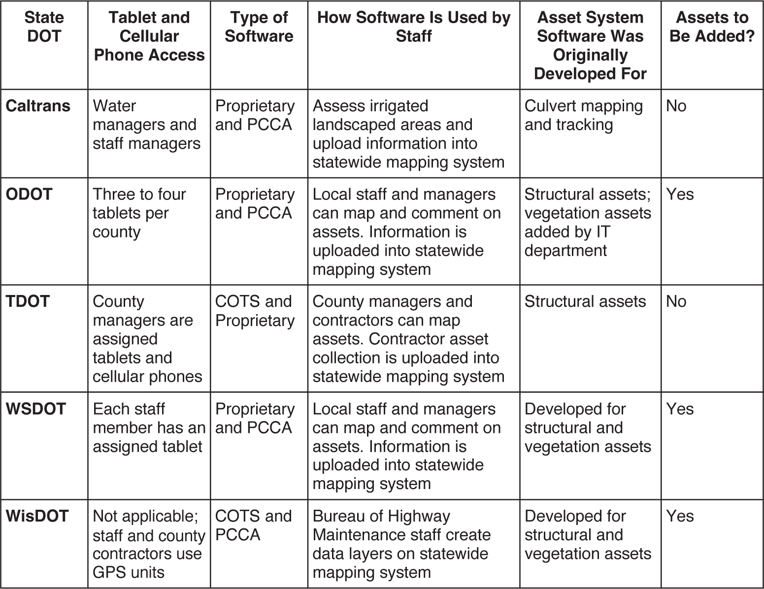
Long Description.
The column headers of the table are State DOT, Tablet and Cellular Phone Access, Type of Software, How Software is Used by Staff, Asset system software was originally developed for, and Additional assets be added. The data given in the table row-wise are as follows: Row 1: Caltrans: Water managers and staff managers; Proprietary and PCCA; Assess irrigated landscaped areas and upload information into statewide mapping system; Culvert mapping and tracking; No. Row 2: ODOT: Three to four tablets per county; Proprietary and PCCA; Local staff and managers can map and comment on assets. Information is uploaded into the statewide mapping system; Structural assets; vegetative assets added by IT department; Yes. Row 3: TDOT: County managers have assigned tablets and cellular phones; COTS and Proprietary; County managers and contractors can map assets. Contractor asset collection is uploaded into the statewide mapping system; Structural assets; No. Row 4: Each staff member has an assigned tablet; Proprietary and PCCA; Local staff and managers can map and comment on assets. Information is uploaded into the statewide mapping system; Developed for structural and vegetative assets; Yes. Row 5: WisDOT: Not Applicable; staff and county contractors use GPS units; COTS and PCCA; Bureau of Highway Maintenance staff create data layers on statewide mapping system; Developed for structural and vegetative assets; Yes.


