Offshore Renewable Energy Development on the West Coast: Understanding Effects on Shipping, Fisheries, and Maritime Activities (2026)
Chapter: 2 Uses of Offshore Areas: Maritime Activity
2
Uses of Offshore Areas: Maritime Activity
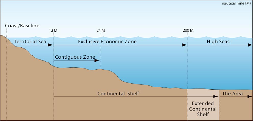
The West Coast of the continental United States has 7,863 mi of shoreline, with major port complexes in the Los Angeles, Seattle, San Francisco, Portland, and San Diego areas (NOAA Office for Coastal Management, n.d.). The U.S. EEZ generally extends offshore from the territorial sea out to 200 NM1 (Figure 2-1). A wide variety of maritime activity operates in, around, and between the ports, up and down the coast, and inside and outside of the EEZ. This chapter first provides an overview of maritime activities within the territorial sea and EEZ. Next is a discussion of the overlaps between certain types of maritime activities. The chapter concludes with a description of recent vessel activity and potential shifts in activity along the U.S. West Coast. This chapter mentions fishing activity, but a detailed discussion is provided in Chapter 3. Discussion of navigational safety, maritime domain awareness, and Coast Guard operations are in Chapter 4. Interactions between maritime activity and ORE development are discussed in Chapter 7.
MARITIME ACTIVITY ON THE WEST COAST
Commercial Shipping
Commercial shipping along the West Coast flows into, out of, and between as many as 14 deep-draft commercial ports from San Diego, California, through Tacoma, Washington (DOC 2025a, 2025b). Commercial ships can be grouped into the following vessel types: bulk carriers, container ships, general cargo ships, oil tankers, chemical tankers, liquefied gas carriers, offshore supply vessels, ferries and passenger ships, and other vessels (UN, 2024). All of these types of vessels, along with smaller types such as towing vessels, barges, and other domestic trade vessels, operate on the West Coast, and many rely on the deep-draft channels.
The Coast Guard, as part of its role in supporting safe maritime activity including proposing routing changes within the territorial seas and ports, or proposing offshore fairways and transit routes to the International Maritime Organization (IMO), conducts a Port Access Route Study (PARS). A PARS presents routing recommendations that include consideration of the access and use needs of shipping, tug and barge activity, commercial and Tribal fishing. From 2021 through 2022 the Coast Guard conducted a PAC-PARS, for the ports of the continental U.S. West Coast (USCG, 2023). During the PAC-PARS study process, the Coast Guard coordinated with other
___________________
1 33 CFR 2.30.
SOURCE: DOS, n.d.
federal and state agencies and engaged with interested parties including maritime community representatives, environmental groups, Tribes, and commercial and recreational fishermen. The Coast Guard engagement process is further discussed in Chapter 7 (Shipping and Coast Guard Maritime Geospatial Planning Considerations). The Coast Guard enacts its final decisions on those recommendations by designating or adjusting fairways, traffic separation schemes, regulated navigation areas, safety zones, and security zones to provide safe access routes for vessel traffic proceeding to and from ports or places that fall under U.S. jurisdiction. As a matter of international law and U.S. policy, these designations recognize “the paramount right of navigation over all other uses” in the designated areas (USCG, 2023).
As a part of the study, the Coast Guard collected information using available data from AIS and VMS on vessels operating along the coast and out to about 200 NM. While these monitoring systems are not required for all vessels and thus cannot provide a complete view of the total traffic along the coast, they do provide a picture of the shipping lanes, which are favored by many operators. Table 2-1 provides an overview, from the PAC-PARS, of the volume and type of traffic operating on the West Coast as informed by AIS and VMS data during a 5-year period. The PAC-PARS classified vessels as cargo (bulk carriers, container ships, general cargo ships), tanker (oil tankers, chemical tankers, gas carriers), passenger, tug/tow, fishing, recreational, and other.
Title 33, Navigation and Navigable Waters, requires AIS to be used on many vessels including certain commercial ships, towing vessels, and passenger vessels.2 AIS data captures the vast majority of commercial ships involved in international and domestic trade but fails to capture vessels that fall below the regulatory threshold and choose not to carry AIS equipment. This includes fishing vessels that are under 65 feet in length and recreational vessels. Some fishing vessels are required by NOAA to carry a VMS, a distinct system used to monitor whether ships are operating in closed areas (NOAA Fisheries, n.d.-b). On the West Coast, the VMS requirements mostly pertain to vessels involved in specific fisheries (see Chapter 3). As a result, the numbers reflected in Table 2-1 vastly underestimate the number of fishing trips during that period. Additional discussion of AIS and VMS can be found in Chapter 4.
___________________
2 33 CFR 164.46.
TABLE 2-1 Vessel Movement (Track Count) by Type along the West Coast (2017-2021)
| Vessel Type | 2017 | 2018 | 2019 | 2020 | 2021 |
|---|---|---|---|---|---|
| Cargo | 8,700 | 8,152 | 7,387 | 16,414 | 30,862 |
| Tanker | 2,768 | 2,179 | 2,008 | 4,674 | 4,570 |
| Passenger | 12,392 | 13,474 | 14,714 | 10,527 | 12,838 |
| Tug/Tow | 2,985 | 2,927 | 2,231 | 2,692 | 3,515 |
| Fishing | 8,595 | 10,594 | 9,687 | 10,103 | 12,536 |
| Recreational | 19,114 | 23,439 | 27,811 | 36,709 | 42,703 |
| Other | 5,686 | 6,523 | 6,002 | 6,014 | 7,293 |
| Total | 60,240 | 67,288 | 69,840 | 87,133 | 114,317 |
NOTE: Cargo includes bulk carriers, container ships, general cargo ships; these are total tracks, not unique vessel tracks.
SOURCE: Modified from PAC-PARS, Enclosure 1.
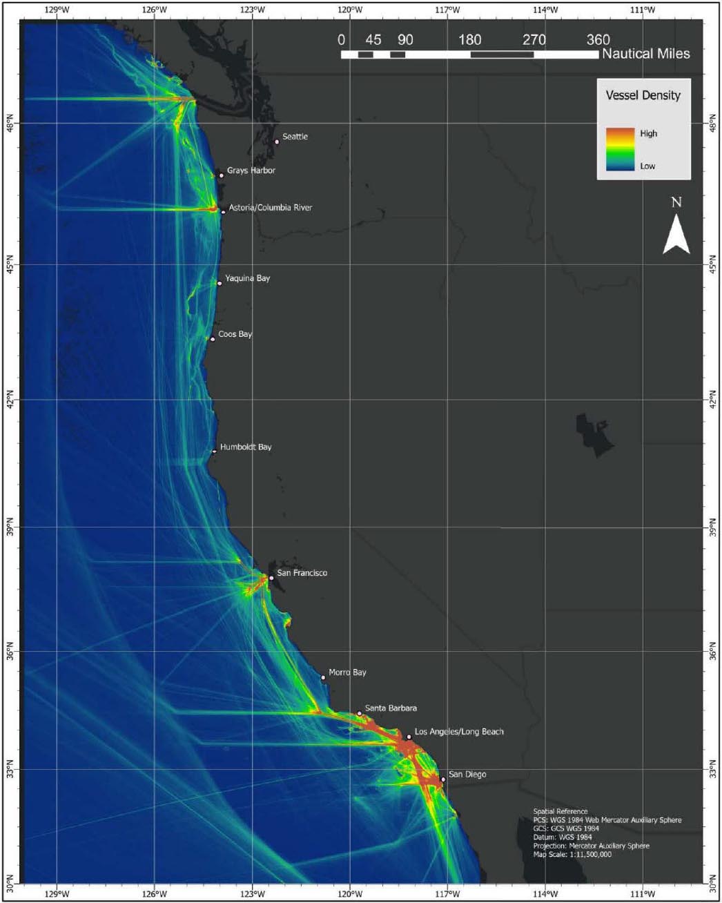
The PAC-PARS consolidated data on commercial vessels’ operating locations on the West Coast and was used to generate heat maps showing vessel transits between 2017 and 2021. Figure 2-2 shows that many of the vessels using AIS follow the same transit patterns. The heat map shows clear east–west transit routes into and out of the ports on the West Coast, with a few transit routes leading diagonally in and out of ports. There are also heavily used north–south transit lanes that follow the coastline, some closer to shore than others.
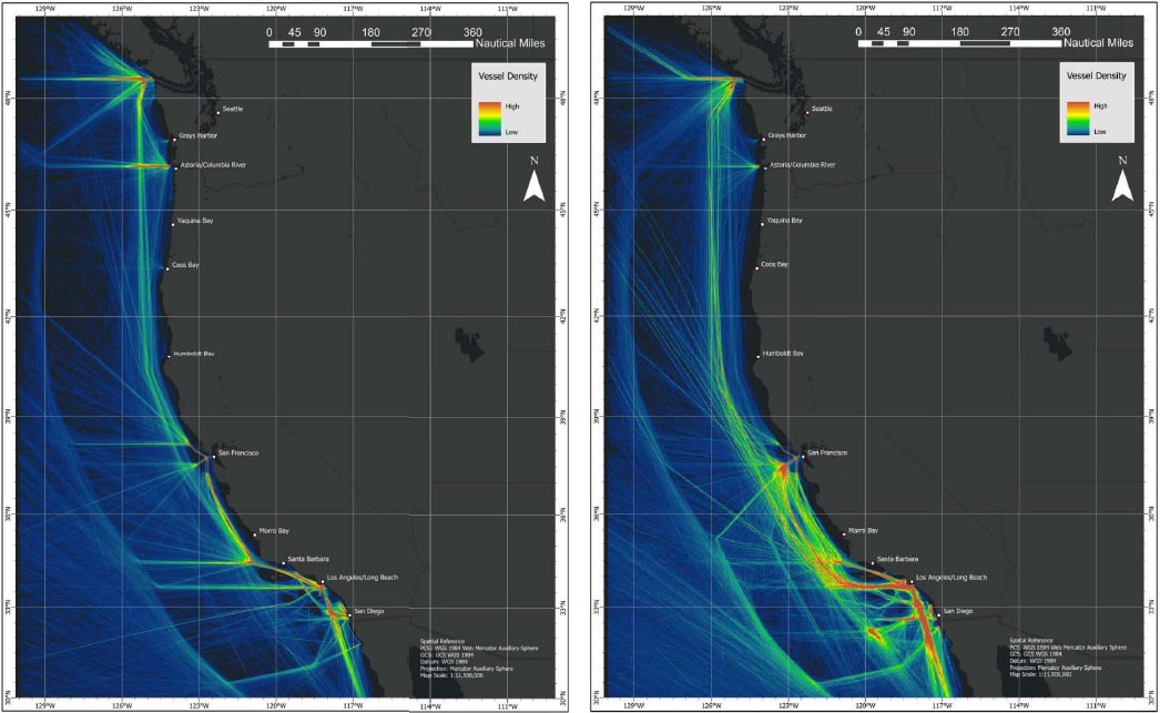
The California Coast Pilot and the Washington/Oregon Coast Pilot both include recommendations for offshore vessel traffic, which was based on a West Coast Offshore Vessel Traffic Risk Management Project published July 2002. The Coast Pilots recommend that vessels 300 gross tons or larger transiting along the coast should voluntarily stay 25 NM or greater distance offshore (unless there is a traffic separation scheme, Vessel Traffic Service, or recommended route; DOC, 2025a, 2025b). It also recommends that tank ships laden with petroleum products should voluntarily stay 50 NM or greater distance offshore. These recommendations are intended to reduce vessel groundings and resulting oil spills, but they do not apply to short coastal transits. The heat map in Figure 2-3 shows that the large majority of cargo and tanker vessels complied with these recommendations.
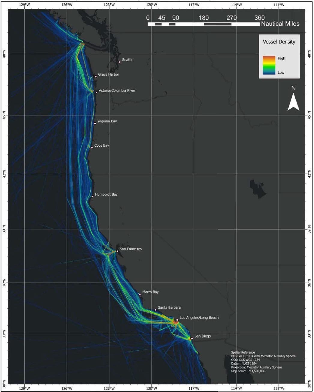
It is important to note that the California Air Resource Board adopted a rule in 2008 prohibiting the use of high sulfur fuels within 24 NM of the state’s shore, which also keeps vessels offshore when not transiting to or from port (CARB, n.d.). Additionally, IMO has implemented an Emissions Control Area on the West Coast, which requires ships to burn cleaner fuels within 200 NM of the coast, and has led to an additional north–south transit lane greater than 200 NM offshore. Some tug and tow vessels also followed the recommended offshore routing, even though they are often smaller than other types of commercial cargo ships. Other tug and tows followed routes that kept them much closer to the shoreline, as seen in Figure 2-4, which was likely due to safety and/or economic reasons.
In addition to the recommended ship routing found in the Coast Pilots, the IMO has adopted four traffic separation schemes, which are published in its international ship routing guidance (IMO, n.d.). These traffic separation schemes are located outside of San Francisco Bay, on the approach to Los Angeles–Long Beach, on the approach to and inside of the Strait of Juan de Fuca, and on the approach to and inside Puget Sound (DOC, 2025a). A traffic separation scheme establishes traffic lanes to separate the opposing streams of traffic.
In 2023 the PAC-PARS made the following recommendations regarding vessel traffic routes for the continental U.S. West Coast, but at the time of this report, these recommendations had not yet been implemented (USCG, 2023):
- Establishing a 15-NM-wide coastwise fairway that connects with existing traffic separation schemes (Strait of Juan de Fuca, San Francisco, Santa Barbara and Los Angeles–Long Beach) and key ports along the West Coast following existing vessel traffic patterns. The Coast Guard had found that coastwise cargo vessel transits tended to follow similar tracks approximately 25–40 NM from shore;
- Establishing a 5-NM-wide nearshore fairway in Northern California and a coastal fairway zone in Oregon and Washington in order to support the Crabber/Towboat Lane Agreement (1971), amended in November 2019;
NOTE: AIS = Automatic Identification System
SOURCE: USCG, 2023, PAC-PARS Enclosure 1.
NOTE: AIS = Automatic Identification System
SOURCE: USCG, 2023, PAC-PARS Enclosure 1.
- Establishing 5-NM-wide voluntary fairways to provide a southern route around the Channel Islands and to provide two angled approach and departure routes to and from the San Diego and Los Angeles areas;
- Removing the existing IMO recommended routes located offshore the Monterey Bay National Marine Sanctuary; and
- Continuing support for bulk chemical and petroleum carriers to voluntarily maintain a minimum of 50 NM offshore where there are not charted lanes in accordance with 2002 Pacific States/British Columbia Oil Spill Task Force recommendations.
Commercial Fisheries
The CCE in the Northern Pacific Ocean is a dynamic and diverse marine environment. This ecosystem spans the entire U.S. West Coast and encompasses the EEZ, the territorial zone, coastal land-sea interface, and adjacent terrestrial watersheds (PFMC, 2022). The diverse and complex ecosystem is home to hundreds of aquatic species, many of which are commercially harvested. These commercial fisheries have significant economic, social, and cultural importance to West Coast communities. A detailed discussion of the commercial fisheries can be found in Chapter 3.
Tribal Fisheries
Along the West Coast, numerous Indigenous Tribes engage in fishing activities. Additionally, treaties reserve the right of several Tribes to fish in their usual and accustomed locations in the Pacific Northwest. Further discussions of Tribal fisheries are contained in Chapter 3.
NOTE: AIS = Automatic Identification System
SOURCE: USCG, 2023, PAC-PARS Enclosure 1.
BOX 2-1
Crabber/Towboat Lane Agreement
An example of shared offshore space benefiting both parties is the agreement developed between Dungeness crabbers and ocean-going tug and barge vessels off the coast of Washington, Oregon, and California. The agreement, brokered by Sea Grant programs in the 1970s, was developed because crab pots were fouling tugs and causing crabbers to lose revenue and replace costly gear. The conflicts were becoming a major problem for both sets of ocean space users (Washington Sea Grant, 2021). The agreement established towboat and barge lanes in crabbing areas from San Franscisco, California north to Cape Flattery, Washington. The tow lanes are flexible and maintained by annual negotiations, with resulting lanes shared and charted. The cooperation works because both industries are accommodated without compromising their values. For example, when fuel prices rose, the crab fleet opened inside tow lanes a month earlier in springtime to shorten the transit distance and save money for the towboat industry, and when crabbers lost access to certain fishing areas in 1994, towboat representatives responded by narrowing the lanes from 2 NM to 1 NM wide (WSG, 2021). A quote from the original tow lane book captures the spirit of the agreement; “A place to fish, a place to tow. Where all mariners benefit, there are no losers in the crabber-towline world.”
SOURCE: WSG, 2021.
Recreational Activity
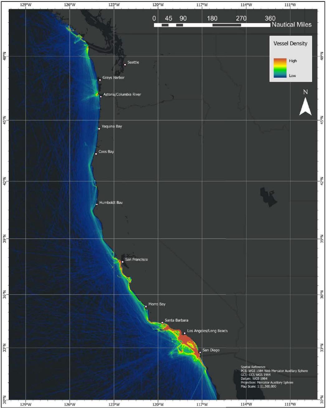
There are a wide variety of recreational activities on the West Coast, which can include recreational fishing, sailing, pleasure boating, wildlife viewing, and offshore athletics such as windsurfing, paddle boarding, scuba diving, and surfing. Many of these activities take place very close to the shoreline with some boat-based activities extending further offshore, such as recreational fishing, although much of the recreational boating traffic is concentrated near shore as well. According to the Coast Guard, more than a million recreational boats were registered in California, Oregon, and Washington in 2023 (USCG, 2024). Some recreational vessels carry AIS equipment, which was captured in the 2023 PAC-PARS as depicted in Figure 2-5, but since AIS is not required on all recreational vessels, the figure does not present a complete picture of recreational activity. The AIS data does show a large concentration of activity in Southern California as well as near-shore dominance for much of the activity.
Military Activities
Along the West Coast are a number of military bases, some of which conduct activities over the water. As discussed later in this chapter, certain offshore military areas can be closed to outside activities in order to protect non-military operations from the danger associated with military testing or training, particularly when weapons are involved.
National Marine Sanctuaries
A national marine sanctuary is a protected area designated to conserve and manage “certain areas of the marine environment [that] possess conservation, recreational, ecological, historical, scientific, educational, cultural, archeological, or esthetic qualities,” along with “human-use values” and living marine resources communities.3 While these areas can allow activities such as responsible commercial and recreational fishing, recreation, and tourism, they focus on providing public education and community engagement without sacrificing conservation
___________________
3 16 USC§ 1431.
NOTE: AIS = Automatic Identification System
SOURCE: USCG, 2023, PAC-PARS Enclosure 1.
and scientific research. Sanctuary habitats are diverse areas; they can encompass entire coral reefs or kelp forests, include whale migration corridors or deep-sea canyons, or be underwater archaeological sites (NOAA National Marine Sanctuaries, n.d.). Sanctuaries are often safe havens for many aquatic species and protect historical sites such as shipwrecks. Each sanctuary is unique, and separate management plans and legal protections are established to properly safeguard each site.
The six sanctuaries on the West Coast are the Channel Islands (California), Chumash Heritage (California), Monterey Bay (California), Greater Farallones (California), Cordell Bank (California), and Olympic Coast (Washington) National Marine Sanctuaries. They range in size from 1,286 sq mi (Cordell Bank) to over 6,000 sq mi (Monterey Bay) (NOAA National Marine Sanctuaries, n.d.; NOAA Cordell Bank National Marine Sanctuary, n.d.; NOAA Monterey Bay National Marine Sanctuary, n.d.) These locations contain a range of habitats and historic sites including kelp forests in the Channel Islands, whale feeding grounds in the Greater Farallones sanctuary, the Rodriguez Seamount in the Chumash Heritage sanctuary, and hundreds of shipwrecks scattered throughout (NOAA National Marine Sanctuaries, n.d.).
Aquaculture
Aquaculture is the act of breeding, raising, and harvesting aquatic plants and animals (NOAA National Ocean Service, n.d.). Marine aquaculture, commonly called mariculture, is the farming of ocean and estuarine resources such as shellfish, fish species like salmon or sablefish, and algae species like kelp. Mariculture methods include net pens which are placed in open water and are used to grow out fish until they’re ready for harvest, or “seeding” the ocean floor or racks with shellfish.
Aquaculture is used to increase food production, restore degraded habitats, or help to rebuild wild populations or stocks of vulnerable species (NOAA National Ocean Service, n.d.). Depending on where an aquaculture farm is located, it may require permits from the U.S. Army Corps of Engineers (USACE), Environmental Protection Agency, NOAA NMFS, or various state agencies (NOAA Fisheries, 2022). On the U.S. West Coast, marine aquaculture produces numerous species of shellfish and finfish and promotes seaweed farming (NOAA Fisheries, n.d.-a).
Offshore Oil and Gas
Five companies operate 23 oil and gas platforms in federal waters off the coast of Southern California (BSEE, n.d.-a). Of the 23, one platform is a processing facility, and the rest were built to produce oil and gas. Pipelines run between the platforms, linking to a hub between several platforms, or even connecting directly to shore. As of December 2024, eight of those platforms were no longer producing and were in various stages of decommissioning (BSEE, n.d.-b).
Offshore Renewable Energy
ORE refers to energy that is harnessed from, on, or above ocean-based resources. This can include capturing energy from winds, solar, ocean currents, waves, tides, ocean thermal gradients and salinity gradients (IRENA, 2020). The present state of offshore wind and hydrokinetic energy (wave and tidal) development and their potential impacts are the main topics of this report. The state of development varies for the respective renewable energy sources, with offshore wind projects further along in the commercialization process. Chapter 5 discusses the development of ORE on the West Coast, focusing on FOW, wave and tidal energy.
Space Launch and Recovery
The West Coast includes a range of space launch activity primarily from the Vandenberg Space Force Base, located northwest of Los Angeles near Point Conception. The base supports launch activities for various federal and military groups as well as some private industry contracts, most notably SpaceX (USSF Vandenberg Space Force Base, n.d.). Over the years, SpaceX has worked to increase its total launch numbers, with the current goal of
95 launches per year despite pushback from the California Coastal Commission (Gorman, 2025). Space launches over water are complex and include not only danger zones and zone clearances around the launch site but special recovery missions for fallen debris and parts (Masunaga, 2021).
Subsurface Cables
The Federal Communications Commission (FCC, n.d.) licenses submarine communication cables and associated cable landing stations in the United States; however, licenses are not required when a cable and both of its terminals lie wholly within the continental United States. Along the West Coast there are numerous cables and landing sites. While landing sites tend to be concentrated to a few main locations, cables run in all directions once they’re offshore. Maps of the West Coast with submarine telecommunication cables and their landing sites can be viewed on the North American Submarine Cable Association website (NASCA, 2025).
Subsurface Mining Activity
Seabed mining is an ongoing, worldwide area of interest. Along the seabed are many minerals, several of which are deemed critical to society, including cobalt-rich crusts, manganese nodules, polymetallic sulfides, and marine phosphorites (PCMSC, 2022). These critical minerals are considered “essential to the economic or national security of the nation and often have a vulnerable supply-chain” (PCMSC, 2022).
While there is not currently any active mining of deep-sea minerals on the International Seabed, recent work is being done to prepare for mining projects. Within the U.S. continental shelf, BOEM oversees prospecting and leasing activities of the seabed, which includes mining activities. In order to learn more about the locations and deposit types of minerals currently on the U.S. continental seabed, BOEM is conducting a National Offshore Critical Minerals Inventory using NOAA and U.S. Geological Survey resources (BOEM, n.d.). Outside the U.S. EEZ, marine mining is governed by the International Seabed Authority, which is currently drafting regulations (PCMSC, 2022).
MARITIME ACTIVITY OVERLAPS
Few offshore locations on the West Coast are reserved exclusively for one particular maritime activity or use. Instead, most locations host a variety of maritime activities. In most cases, when there are competing demands on the use of the waterway, maritime activities have achieved a relative balance among each other. This section provides a general overview of the interactions between the different types of maritime activities on the West Coast. The discussion focuses on what activities cannot take place in the same maritime space as others and is primarily centered on activities that exist or are planned at the time of this report. The Committee recognizes that there will be additional novel and new maritime activity overlaps in the future that are not addressed in this report.
Commercial Shipping
Given the number and the size of commercial ships moving along the West Coast, many maritime activities either voluntarily try to avoid operating in commercial shipping lanes or do not receive permits to operate in those locations. Commercial fishing, Tribal fishing, and recreational boating are all allowed in commercial shipping lanes, but they generally try to reduce their time spent in a shipping lane or plan their activities when there is less traffic. Additionally, there can be regulatory restrictions within narrow channels and traffic separation schemes. In accordance with the 1972 International Regulations for Preventing Collisions at Sea and 1980 U.S. Inland Navigation Rules (H.R. 6671), fishing vessels cannot actively obstruct navigation through narrow channels or fairways or impact the passage of vessels following traffic lanes. Vessels smaller than 20 m and sailboats must follow similar rules. They cannot obstruct power-driven vessels in a traffic lane or inhibit passage of vessels with limited navigational options in narrow channels or fairways.
Offshore oil and gas facilities cannot be located within federally or internationally designated fairways or traffic separation schemes. They may be located in informal shipping lanes but that can lead to an increased risk of allisions (when a ship strikes a stationary object). The same will be true for ORE facilities that are installed in the future. Thousands of oil and gas facilities, both fixed and floating, operate in the Gulf of Mexico which create a complicated maze for commercial ships to navigate.
It is far less risky to site offshore facilities outside shipping lanes, which was the rationale behind the Coast Guard’s PAC-PARS. The Coast Guard, wanting to ensure the safety of navigation along the West Coast with the rapidly changing demand for the use of coastal waters, aimed to study whether new or modified vessel routing measures should be established. Using vessel traffic data from the past decade and input from key stakeholders, Tribal governments, and the public, PAC-PARS resulted in a series of recommendations to ensure continued safe, efficient, and predictable vessel navigation alongside other reasonable waterway uses. The study recommended establishing voluntary shipping fairways for coastwise and nearshore vessel traffic to promote safe and unobstructed navigation. If these shipping fairways are implemented, they will provide a clear picture of areas that future maritime activities should avoid such as an ORE project or a mining project with a surface facility. Although the use of fairways is voluntary, most vessels have historically complied with the recommended lanes.
Conclusion 2-1: The committee found that the Pacific Area Port Access Route Study routing recommendations were developed using a comprehensive process that engaged Tribes, federal and state agencies, and stakeholders, considered current and future maritime activities, and provided for the current use and further growth of shipping.
Commercial and Tribal Fishing
As seen in Chapter 3, a wide variety of locations up and down the West Coast experience commercial and Tribal fishing. Fishing in a particular location does not typically prevent other maritime activities from happening in that same location. On the other hand, many maritime activities can prevent or restrict fishing in a particular location. As such, new maritime activities and uses should account for fishing grounds and seek ways to allow coexistence. Agencies planning maritime activities should consider potential shifts in the distribution of fishing activity due to factors such as expansion of conservation areas, or impacts to commercially and recreationally targeted fish stocks due to changing ocean conditions.
Marine Life
In some cases, maritime activities need to account for the presence of marine life, particularly as it relates to whale strikes. Vessel speed reductions are one example of a method management agencies can promote to help protect this wildlife (NOAA Greater Farallones National Marine Sanctuary, n.d.). These speed reductions occur in specific areas and ask vessel operators to reduce their speed, often to 10 knots, while transiting within specific areas. This reduction can help reduce the risk of fatal whale strikes to protected species along the coast, as well as reducing noise and air pollution in the area. Along the West Coast, there are two examples of vessel speed reduction zones. NOAA issues voluntary vessel speed reductions off San Francisco, Monterey, and Southern California from May–December (NOAA Greater Farallones National Marine Sanctuary, n.d.). The second occurs near the Straits of Juan de Fuca, assisting with the Port of Vancouver’s Enhancing Cetacean Habitat Observation Program (Port of Vancouver, 2025).
Recreational Activity
There are few situations where recreational activities prevent other maritime activities in the same location, because, in most cases, people engaged in recreation try to avoid other maritime activities. Exceptions can occur when large, organized events, like regattas, marine parades, or recreational fishing contests, “introduce extra or
unusual hazards that could impact safety of the waterways.”4 The Coast Guard requires these large events, or any event that is expected to draw crowds (e.g., sailing races), to acquire permits in order to promote safety. A marine event permit may or may not include additional regulations, such as vessel restrictions.
Military Activity
When military activities occur over water, the area associated with military activity can fall into two categories: danger zones and restricted areas. Danger zones are designated areas for operations such as rocket launches, target practices, and other hazardous activities. Restricted areas are places that limit public access.5 Danger zones can be implemented full-time or as needed to align with the military’s needs. Restricted areas are often used to provide additional security for government property or to reduce the risk to the public from military activity.
There are several large danger zones located offshore Point Mugu, California, and San Clemente Island, California, along with several smaller danger zones near Naval Base Coronado, California, San Pedro, California, San Miguel Island, California, Fort Ord, California, and Camp Rilea, Oregon. Restricted areas are typically located in the immediate vicinity of military bases that have waterfront access, both coastal and inland.
National Marine Sanctuaries
The National Marine Sanctuaries Act6 is the statutory framework governing national marine sanctuaries. Each national marine sanctuary has its own set of regulations outlining prohibited activities within its boundaries, but many of the requirements are similar. Within all the national marine sanctuaries, certain activities are prohibited in order to protect the ecological and cultural integrity of the sites. Such activities include exploring for or extracting oil, gas, or minerals (except in existing leases), discharging or depositing materials into the sanctuary from within or beyond its boundaries (with limited vessel-related exceptions), and disturbing historical and ecological resources unless permitted for lawful fishing, aquaculture, or kelp harvesting. Additional restrictions are placed on drilling, dredging, or placing structures on submerged lands or the taking or possession of marine mammals, sea turtles, or seabirds without legal authorization. Introducing nonnative species is generally banned, except for specific cases like releasing striped bass during catch-and-release fishing on the Wast Coast and authorized aquaculture in Tomales Bay. The above prohibitions do not apply to certain military activities, activities that are specifically permitted by the sanctuary, or when an activity is necessary to respond to an emergency. Moreover, this is not an exhaustive list. National marine sanctuaries have individual management plans, which should be consulted for information about other activities. For example, depending on the sanctuary and the location inside it, there may be restrictions on fishing, fishing gear, anchoring, vessel traffic, and motorized aircraft or motorized personal watercraft.
Aquaculture
At the moment, aquaculture is not expected to overlap with West Coast FOW development, as aquaculture is typically closer to shore than the areas with the greatest wind energy resource. However, there is some anticipation of possible overlap or co-location with wave and tidal projects. Information on areas of overlap can be found in the Final Programmatic Environmental Impact Statement (EIS) for the Identification of Aquaculture Opportunity Areas in U.S. Federal Waters off Southern California (NMFS, 2025).
Offshore Oil & Gas
Offshore oil and gas platforms prevent other activities from happening in the same location. Activities such as shipping, fishing, and recreation may be able to operate or navigate around the platforms, but activities like other offshore energy facilities, aquaculture, or mining projects cannot be located in the same place. Structures and their
___________________
4 33 CFR Part 100.
5 33 CFR Part 334.
6 16 U.S.C. 1431 et seq.
moorings must avoid defined submarine cables routes. Military activity cannot take place on or under the surface of the ocean in the position of an oil and gas platform but might occur in the airspace above it.
In addition to the above restrictions, 15 of the 23 oil and gas platforms on the West Coast have established safety zones around them.7 These zones prohibit vessels that are 100 ft or longer, or vessels engaged in towing, from coming within 500 m of the structure’s outer edge. For platforms that do not have published safety zones, a vessel can get as close as it wants to the facility without penalty.
Offshore Renewable Energy
An ORE platform would likely have the same localized impacts as an offshore oil and gas platform. An array of offshore wind energy platforms would have additional impacts on some maritime activities. While the United States does not prevent vessels from operating within a wind turbine array, limitations would likely cause some types of vessels to avoid the entire offshore wind array. Large commercial vessels would likely transit around a wind array, due to the spacing of the wind turbines in comparison to the turning radius of the vessel. Commercial fishing vessels using bottom-tending gears, mid-water trawls, or purse seine gear and research (survey) vessels using similar types of gear and instruments would likely not have enough space to conduct operations between wind turbines either, due to the length of their gear, operational needs of the gear, the presence of inter-array cables suspended between the turbines, and the distance between turbine platform moorings. Other types of commercial fishing vessels might fish inside of a wind array, dependent on the size and spacing of the turbines and presence of inter-array cables suspended in the water column. Discussion of transit corridors in ORE wind arrays is presented in Chapter 7.
Other types of ORE projects, such as wave energy converters or tidal energy converters, if installed on the surface, would have similar impacts as an offshore oil and gas platform. Projects installed below the surface of the ocean might present fewer impacts on other maritime activities, depending on the depth of water and the type of infrastructure installed for the project.
Potential Offshore Wind Development
Currently there are no commercial ORE projects on the West Coast, but there has been a strong interest in pursuing them to meet individual states’ carbon and greenhouse gas reduction goals. The State of California has established a goal of 100 percent zero-carbon energy by 2045 (CEC, 2024). This planning goal includes the installation of 25 GW of offshore wind energy capacity by 2045.
Outside California, Oregon’s Clean Energy Targets Bill established a greenhouse reduction goal of 100 percent to be reached in 2040 (ODEQ, n.d.). The Oregon State Legislature passed this bill to require reductions in greenhouse gas emissions from energy suppliers and developed a target-centered plan to achieve their goal by 2040. Additionally, Oregon required its Department of Land Conservation and Development to create an offshore wind energy roadmap which would outline the standards and process required for an offshore wind development project to be considered in Oregon (Oregon Coastal Management Program, n.d.).
Since 2019 Washington has implemented its Clean Energy Transformation Act with the goal of achieving electricity without greenhouse gas emissions by 2045 (WSDC, n.d.). Utility companies are required to create plans that meet the act’s requirements.
Space Launch and Recovery
Due to the potential for debris falling after a space launch, there is a danger zone located offshore Vandenberg Space Force Base. This danger zone area is subdivided into nine smaller zones in order to limit the amount of space required to be evacuated during tests and operations.8 When there are no active space launches, much of the danger zone is open to fishing and navigation, but once a launch is scheduled to occur closures are announced,
___________________
7 33 CFR 147.
8 33 CFR 334.1130.
and vessels must leave the area during the prescribed time. Fixed and movable oil drilling platforms located inside the danger zone must halt operations throughout the closure.
Subsurface Cables
Subsurface cables are identified on nautical charts after information is reported to NOAA and the responsible agency recommends they be charted. While the presence of subsurface cables does not prevent another maritime activity from operating in that location, vessel operators must be aware and cautious when anchoring, fishing or engaging in underwater operations near reported cable areas, as there could be severe consequences for both the vessel and the cable if an anchor or gear is fouled on a submarine cable. The location of a cable can shift after it is installed and charted, and cables that were originally buried can later become exposed. Additionally, some cables carry high voltages (DOC, 2025a).
The installation of ORE will likely require the installation of new subsurface cables. These cables could be co-located and routed into existing cable routes. Cable placement will be an important consideration for future ORE developments.
Subsurface Mining Activity
As of 2025, there is no mining of deep-sea critical minerals. As such, it is hard to know exactly what type of maritime activities would be impacted by a mining project. A subsurface mining project with associated operations or facilities on the surface of the water would likely prevent most other activities from occurring nearby during operations. Shipping, fishing, and recreational activity could not take place, and new subsurface cables could not be installed in the same space as active mining projects. Offshore energy facilities and aquaculture projects likewise could not be in the same position. If a subsurface mining project did not involve any surface operations or facilities, there might be less impact on other maritime activities, depending on how much the mining activity disturbed the water or the aquatic life.
POTENTIAL SHIFTS IN MARITIME ACTIVITY
It is difficult to predict the future of maritime activity on the West Coast. Many factors affect what is happening offshore, such as climate variability; economics, including national interests in reshoring manufacturing; geopolitical risks; changing demographics; the need for supply chain resiliency; and emerging technologies.
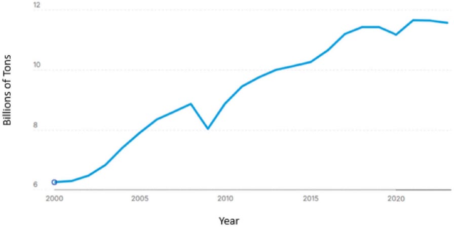
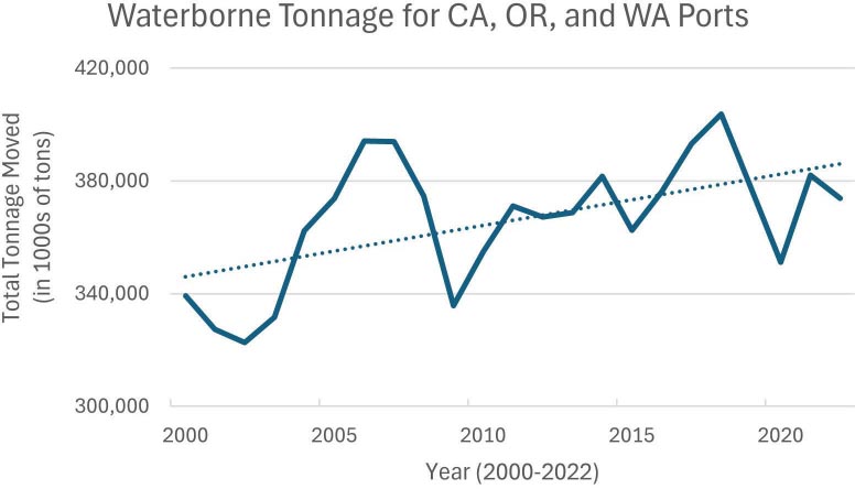
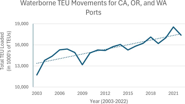
The volume of commercial shipping is expected to increase, based on a continuing trend of increases in global maritime trade over the last 50 years (UNCTAD, n.d.). Figure 2-6 and Table 2-2 show the long-term growth in metric tons of goods moved in global maritime trade since 2000 (Figure 2-6) and millions of tons loaded since 1970 (Table 2-2). Figures 2-7 and 2-8 show trends of tonnage (Figure 2-7) and TEUs (Figure 2-8) moving through U.S. West Coast ports also increased since the early 2000s through 2022. The United Nations Conference on Trade and Development forecasts continued growth in the coming years, although it hesitates to provide quantitative prediction due to significant uncertainty related to other factors.
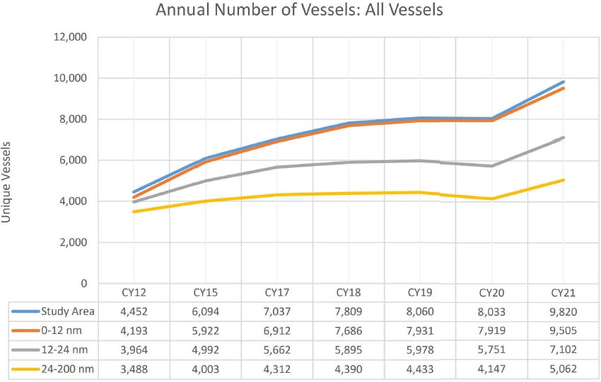
Shipping and vessel activity on the West Coast follows the global trend of increased activity when comparing AIS data from 2012 to 2021 (Figure 2-9). Although it is uncertain at the time of writing whether or not increasing trends will continue, the last decade’s trends are evident.
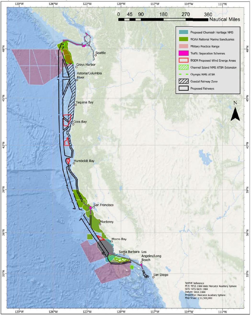
With a continued projected growth in the volume of commercial shipping around the world and off the U.S. West Coast, it is important to discuss where those ships may operate. The PAC-PARS concluded that due to the continued growth of competing waterway uses and projects off the coasts of California, Oregon, and Washington, there was a need for safe access routes that could allow vessels to move along the coast and in and out of ports. The report recommended six voluntary fairways for vessel traffic (see Figure 2-10), which are designed to accommodate the current and future navigation requirements necessary to maintain the safe and reliable shipping routes on the West Coast, while also accommodating other reasonable waterway uses. Once the Coast Guard completes the steps to implement these voluntary fairways, most of the commercial vessel traffic is expected to use these them.
NOTE: In billions of tons.
SOURCE: Modified from UNCTAD, n.d.
Table 2-2 International Maritime Trade in Millions of Tons Loaded
| Year | Tanker | Bulk Carrier | Other Dry Cargo | Total Cargo |
|---|---|---|---|---|
| 1970 | 1,440 | 448 | 717 | 2,605 |
| 1980 | 1,871 | 608 | 1,225 | 3,704 |
| 1990 | 1,755 | 988 | 1,265 | 4,008 |
| 2000 | 2,163 | 1,186 | 2,635 | 5,984 |
| 2005 | 2,422 | 1,597 | 3,108 | 7,109 |
| 2010 | 2,752 | 2,232 | 3,423 | 8,408 |
| 2015 | 2,932 | 2,930 | 4,161 | 10,023 |
| 2019 | 3,163 | 3,218 | 4,690 | 11,071 |
| 2020 | 2,918 | 3,196 | 4,531 | 10,645 |
| 2021 | 2,952 | 3,272 | 4,761 | 10,985 |
NOTE: Tanker includes crude oil, refined petroleum products, gas, and chemicals. Bulk Carrier includes iron ore, grain, coal, bauxite/alumina and phosphate (until 2005). Other Dry Cargo includes bauxite/alumina and phosphate (from 2006), containerized trade, and residual general cargo.
SOURCE: Modified from Christiansen et al., 2025.
NOTE: In thousands of tons from 2000 to 2022.
SOURCE: Created by the Committee using data from USACE, 2022b.
NOTE: In thousands of TEUs from 2003 to 2022. TEU = Twenty-foot Equivalent Units.
SOURCE: Created by the Committee using data from USACE, 2022a.
NOTE: CY = calendar year.
SOURCE: USCG, 2023, PAC-PARS Enclosure 1, Attachment 2
NOTE: The Chumash Heritage National Marine Sanctuary (shown as proposed) was designated in November 2024. ATBA = Area to Be Avoided; BOEM = Bureau of Ocean Energy Management; NMS = National Marine Sanctuary.
SOURCE: USCG, 2023, PAC-PARS Appendix 1.
REFERENCES
BOEM (Bureau of Ocean Energy Management). n.d-a. “Critical Minerals.” https://www.boem.gov/marine-minerals/critical-minerals (accessed December 14, 2025).
BSEE (Bureau of Safety and Environmental Enforcement). n.d. “Pacific OCS Platforms.” Last https://www.bsee.gov/stats-facts/ocs-regions/pacific/pacific-ocs-platforms (accessed December 14, 2025).
BSEE. n.d-b. “Pacific Region Federal OCS Decommissioning.” https://www.bsee.gov/stats-facts/ocs-regions/pacific/pacific-region-federal-ocs-decommissioning (accessed December 14, 2025).
CARB (California Air Resources Board). n.d. “Ocean-Going Vessel Fuel Regulation.” https://ww2.arb.ca.gov/our-work/programs/ocean-going-vessel-fuel-regulation (accessed January 6, 2026).
CEC (California Energy Commission). 2024. “CEC Adopts Offshore Wind Energy Strategic Plan to Support California’s 100% Clean Electricity Future.” https://www.energy.ca.gov/news/2024-07/cec-adopts-offshore-wind-energy-strategic-plan-support-californias-100-clean (accessed December 14, 2025).
Christiansen, Marielle, Kjetil Fagerholt, and David Pisinger. 2025. “Fifty years on maritime transportation.” EURO Journal on Transportation and Logistics 14:100148. doi: 10.1016/j.ejtl.2024.100148.
DOC (United States Department of Commerce). 2025a. United States Coast Pilot 7 Pacific Coast — California. https://nauticalcharts.noaa.gov/publications/coast-pilot/files/cp7/cpb7_web.pdf.
DOC. 2025b. United States Coast Pilot 10 Oregon, Washington, Hawaii, and Pacific Islands. https://nauticalcharts.noaa.gov/publications/coast-pilot/files/cp10/cpb10_web.pdf.
DOS (United States Department of State). n.d. “About Extended Continental Shelf.” https://www.state.gov/about-ecs (accessed December 14, 2025).
FCC (Federal Communications Commission). n.d. “Submarine Cable Landing Licenses.” https://www.fcc.gov/research-reports/guides/submarine-cable-landing-licenses (accessed December 14, 2025).
Gorman, Steve. 2025. “California Coastal Commission opposes SpaceX launch expansion on West Coast, again.” Reuters. https://www.reuters.com/sustainability/climate-energy/california-coastal-commission-opposes-spacex-launch-expansion-west-coast-again-2025-08-15/. (accessed December 14, 2025).
IMO (International Maritime Organization). n.d. “Ships’ routing.” https://www.imo.org/en/ourwork/safety/pages/shipsrouteing.aspx (accessed December 14, 2025).
IRENA (International Renewable Energy Agency). 2020. Fostering a blue economy: Offshore renewable energy. Abu Dhabi: IRENA.
Masunaga, Samantha. 2021. “SpaceX strikes a deal with Port of Long Beach (for real this time, mayor says).” Los Angeles Times. https://www.latimes.com/business/story/2021-04-26/spacex-port-of-long-beach-rocket-recovery. (accessed December 14, 2025).
NMFS (National Marine Fisheries Service). 2025. Final programmatic environmental impact statement for the identification of aquaculture opportunity areas in U.S. federal waters off of Southern California. https://s3.amazonaws.com/media.fisheries.noaa.gov/2025-09/wcr-aoa-fpeis-2025.pdf.
NOAA (National Oceanic and Atmospheric Administration) Cordell Bank National Marine Sanctuary. n.d. “About.” https://cordellbank.noaa.gov/about (accessed December 14, 2025).
NOAA (National Oceanic and Atmospheric Administration) Fisheries. 2022. Guide to Permitting Marine Aquaculture in the United States. https://www.fisheries.noaa.gov/s3//2022-07/Guide-Permitting-Marine-Aquaculture-United-States-June2022.pdf.
NOAA Fisheries. n.d.-a. “Aquaculture on the West Coast.” https://www.fisheries.noaa.gov/west-coast/aquaculture/aquaculture-west-coast (accessed December 14, 2025).
NOAA Fisheries. n.d.-b. “Regional Vessel Monitoring Information.” https://www.fisheries.noaa.gov/national/enforcement/regional-vessel-monitoring-information (accessed December 14, 2025).
NOAA (National Oceanic and Atmospheric Administration) Greater Farallones National Marine Sanctuary. n.d. “Voluntary Vessel Speed Reduction Requests.” https://farallones.noaa.gov/eco/whales/vessel-speed-reduction.html (accessed December 14, 2025).
NOAA (National Oceanic and Atmospheric Administration) Monterey Bay National Marine Sanctuary. n.d. “About.” https://montereybay.noaa.gov/intro (accessed December 14, 2025)
NOAA (National Oceanic and Atmospheric Administration) National Marine Sanctuaries. n.d. “West Coast Region.” https://sanctuaries.noaa.gov/about/westcoast.html (accessed December 14, 2025).
NOAA (National Oceanic and Atmospheric Administration) National Ocean Service. n.d. “What is aquaculture?” https://oceanservice.noaa.gov/facts/aquaculture.html (accessed December 14, 2025).
NOAA (National Oceanic and Atmospheric Administration) Office for Coastal Management. n.d. Shoreline mileage of the United States. https://shoreline.noaa.gov/.
NASCA (North American Submarine Cable Association). 2025. “Cable Maps – West Coast Region.” https://www.n-a-s-c-a.org/cable-maps-all-regions/cable-map-regions-west-coast (accessed December 14, 2025).
ODEQ (Oregon Department of Environmental Quality). n.d. “Oregon Clean Energy Targets.” Oregon Department of Environmental Quality. https://www.oregon.gov/deq/ghgp/pages/clean-energy-targets.aspx (accessed December 14, 2025).
Oregon Coastal Management Program. n.d. “Oregon Offshore Wind Energy Roadmap.” Department of Land Conservation and Development. https://www.oregon.gov/lcd/ocmp/pages/offshore-wind-roadmap.aspx (accessed December 14, 2025).
PCMSC (Pacific Coastal and Marine Science Center). 2022. “Global Seabed Mineral Resources.” USGS. https://www.usgs.gov/centers/pcmsc/science/global-seabed-mineral-resources (accessed December 14, 2025).
PFMC (Pacific Fishery Management Council). 2022. Pacific Coast fishery ecosystem plan for the U.S. portion of the California current large marine ecosystem. https://www.pcouncil.org/documents/2022/04/pacific-coast-fishery-ecosystem-plan-march-2022.pdf.
Port of Vancouver. 2025. “Learn more about the ECHO Program’s 2025 voluntary slowdowns and route alteration for commercial ships.” https://www.portvancouver.com/article/echo2025voluntaryinitiatives. (accessed December 14, 2025).
WSG (Sea Grant Washington). 2021. “Celebrating 50 Years of Brokering Lane Agreements Between Crabbers and Towboat Operators.” University of Washington. https://wsg.washington.edu/crabtowlanes (accessed January 6, 2026)
UN (United Nations). 2024. Review of maritime transport 2024: Navigating maritime chokepoints. https://unctad.org/system/files/official-document/rmt2024_en.pdf.
UNCTAD (UN Trade and Development). n.d. “Maritime and other transport.” UN Trade and Development (UNCTAD). https://unctadstat.unctad.org/insights/theme/109 (accessed December 14, 2025).
USACE (United States Army Corps of Engineers). 2022-a. “Waterborne container traffic.” https://usace.contentdm.oclc.org/digital/collection/p16021coll2/id/14565 (accessed January 4, 2026).
USACE. 2022-b. “Waterborne tonnage for principal U.S. ports and all 50 states and U.S. territories; Waterborne tonnages for domestic, foreign, imports, exports and intra-state waterborne traffic.” https://usace.contentdm.oclc.org/digital/collection/p16021coll2/id/14589 (accessed January 4, 2026).
USCG (United States Coast Guard). 2023. Pacific Coast port access route study. https://www.navcen.uscg.gov/port-access-route-study-reports.
USCG. 2024. 2023 Recreational boating statistics. https://corpslakes.erdc.dren.mil/employees/watersafety/pdfs/2023%20Recreational%20Boating%20Statistics.pdf.
USSF (United States Space Force) Vandenberg Space Force Base. n.d. “About Us.” https://www.vandenberg.spaceforce.mil/About-Us (accessed December 14, 2025).
WSDC (Washington State Department of Commerce). n.d. “Clean Energy Transformation Act (CETA).” https://www.commerce.wa.gov/energy-policy/electricity-policy/ceta (accessed December 14, 2025).


