Geospatial Data Governance Policies and Procedures: A Guide (2025)
Chapter: Appendix B: Sample Geospatial Data Governance Policy
APPENDIX B
Sample Geospatial Data Governance Policy
Purpose
The purpose of this document is to provide a geospatial data governance policy for the [SAMPLE AIRPORT]. The policy itself is a collection of principles, frameworks, programs, roles, and responsibilities that help manage data collection. A geospatial data governance policy is both an organizational process and a structure. It defines the organizational processes to manage data collection, storage, access, usage, quality, and archiving of geospatial data assets in the geospatial data’s entire life cycle. It establishes a data governance structure for the managing organization.
The intent of this policy is to
- Establish a common vision on how geospatial data can be utilized to better accomplish the [SAMPLE AIRPORT]’s mission, goals, and objectives.
- Decrease the time it takes staff to do certain aspects of their jobs (“do more with less”).
- Improve the accuracy, availability, security, and coordination of geospatial data.
- Break down interdepartmental silos, create data sets that are used across departments, and eliminate disparate data sets.
- Improve the metadata on data collects so that there is a better understanding of the accuracy level, collection dates, and source of the data.
- Enforce security and privacy of data.
- Establish ownership and accountability for the management of data as an organizational asset.
- Allow for informed decision making due to having a higher quality of geospatial data.
Intended Audience
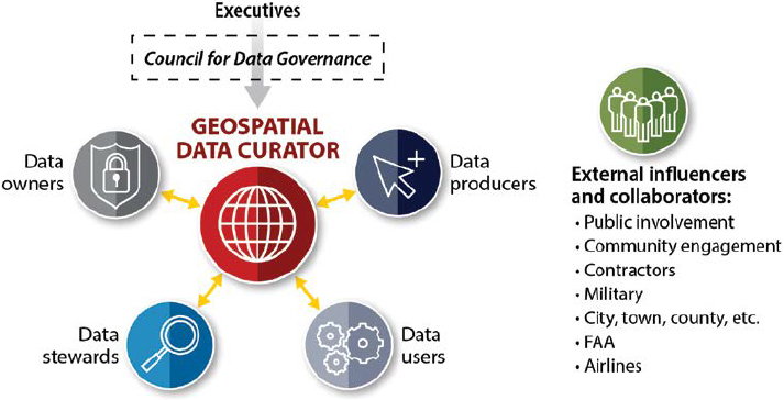
This document is intended to be used by people who maintain or create geospatial data at the [SAMPLE AIRPORT]. All [SAMPLE AIRPORT] staff and outside consultants should understand the requirements of this policy and follow its specifications for the review, collection, dissemination, updating, and delivery of geospatial data to the [SAMPLE AIRPORT]. This would include the geospatial data curator, data owners, data stewards, data producers, data users and external influencers and collaborators.
Related Documents
The following documents contain information related to this document. The documents listed include standards, regulations, or reference materials. In addition to this geospatial data governance policy document, the [SAMPLE AIRPORT] has developed the following related documents:
The following documents are available from sources outside of the [SAMPLE AIRPORT]:
- National CAD Standard (National Institute of Building Sciences 2022);
- 49 CFR 1520 defines sensitive security information and how it is to be handled—this document is a federal regulation that applies to all citizens of and agencies within the United States, Protection of Sensitive Security Information, United States Code of Federal Regulations, Title 49, Volume 9, Part 1520, revised as of October 1, 2005 (TSA 2004); and
- FAA AC 150/5300-18B—General Guidance and Specifications for Submission of Aeronautical Surveys to NGS: Field Data Collection and GIS Standards, issued February 24, 2014, defines GIS and CAD data standards for airport data delivered to the FAA (AAS-100 2014).
Organizational Alignment
Within a geospatial data governance policy, it is imperative that the organization be in alignment. Although there are many ways organizations can align themselves, almost every organizational chart includes a council for data governance, has a geospatial data curator (which may or may not be their full-time position), and has data owners, data stewards, data producers, data users, and external influencers and collaborators. Figure B-1 shows a simplified organizational alignment.
Governance Committee Roster
Gather the following information to create a roster. When more than one person performs a function, list each separately by job function.
- List all members of the Council for Data Governance with first and last name, title, email, and phone.
- List the Geospatial Data Curator’s first and last name, title, email, and phone.
- List Data Owners, Stewards, Producers and Users Representatives with first and last name, title, email, and phone.
Data Access
Data access is the ability of a collaborator to retrieve, manipulate, copy, or move data in an on-demand environment. In an airport environment, there are a multitude of users accessing geospatial data across departments at any given time. Having and ensuring that this data is available ensures the value of the data is being maximized. However, misusing or unnecessarily restricting data can be the source of frustrations and inefficiencies if the access controls are not properly deployed. With the airport environment containing many sensitive security information (SSI) features, ensuring that the appropriate level of access is defined for each asset type or feature is critical. The council for data governance should be responsible for the assignment of an appropriate level of access for each feature and this should be coordinated with the [SAMPLE AIRPORT]’s Information Technology (IT) team. Data for which a collaborator does not have appropriate access but feels that they should, a request can be made to the council for data governance or the data steward to review.
Data Usage
Any data from the [SAMPLE AIRPORT] utilized by an individual must be used only as required for the performance of their job function. It is important that as an organization the [SAMPLE AIRPORT] considers privacy aspects of its data, limits or restricts potential misuses of the data, and that the data is used ethically. It is the responsibility of the data steward or owner to assign security levels.
There are typically a minimum of two different levels of access to data, which includes read-only access and write access or the ability to manipulate and modify data. While user constraints can be input into an infinite number of working groups, each with a different level of access to manipulate, read, write, or delete data, permissions to manipulate and modify data should only be provided to those whose job duties reflect this responsibility. By limiting write access, data mishaps can be prevented from both intentional and unintentional parties.
Data Integrity and Integration
Data integrity refers to the accuracy, consistency, and completeness of data. Data integration is the process of unifying disparate data systems from across multiple sources to form a unified data set. Data stewards and owners should take into consideration the needs of the [SAMPLE AIRPORT] in the development of and modification of assets, their attribute values, and domains. Discussing any data collection projects with the council for data governance is highly recommended before the deployment of any new data collection processes. By performing a review with the data council, the following benefits can be gained:
- Reduction of duplicate collection efforts if the needs of multiple departments can be met in a single collection effort/mobilization.
- Assurance that the data collected is accessible and usable to each department at the appropriate access level.
- Assurance that the data is best collected in a manner that allows for data interoperability between enterprise solutions (i.e., attribute data for GIS from traditional CAD data sets).
Metadata consists of detailed information about the data set—how it was created and by whom. Metadata can provide a description of the feature, and it can help users organize, find, and understand data. All data provided to the [SAMPLE AIRPORT] shall have metadata completed to assist with the data integrity.
Suggested Language for Contracts and Agreements
All projects at the [SAMPLE AIRPORT] that construct new or modify existing facilities on airport property must also submit as-built data that complies with this geospatial data governance policy and any other applicable standards (see the Related Documents Section of this policy). Because this policy is a dynamic document that can change over time, contractors and consultants will be provided the most recent version of the geospatial data governance policy at the kick-off meeting to each project.
While this document does not get into the specifics of data collection, the FAA’s ADIP System, which is a requirement for all FAA AIP-funded programs, should also be referenced. These requirements are established in the following FAA ACs:
- AC 150/5300-16B—General Guidance and Specifications for Aeronautical Surveys: Establishment of Geodetic Control and Submission to the NGS (AAS-100 2019).
- AC 150/5300-17C—Standards for Using Remote Sensing Technologies in Airport Surveys (AAS-100 2011).
- AC 150/5300-18B—General Guidance and Specifications for Submission of Aeronautical Surveys to NGS: Field Data Collection and GIS Standards (AAS-100 2014).
The contractor and consultant shall become familiar with all applicable [SAMPLE AIRPORT] and FAA requirements through training, certification, and/or other means. The [SAMPLE AIRPORT] will not pay for any direct costs associated with such training or certification.
If the contractor or consultant does not follow the recommended geospatial data policy guidelines or the guidelines of the other related documents within this policy, the contractor or consultant may be withheld final payment or assessed a penalty as determined by the [SAMPLE AIRPORT].
Incremental Deliveries
Incremental deliveries for geospatial projects can be difficult considering the seamless nature of most vector data sets and cloud GIS deliverables. A complete delivery is desirable rather than tiled components that eventually must be puzzled back together, potentially causing issues such as topological gaps and slivers. To mitigate possible errors, industry best practice is to perform a pilot initial data delivery which is ultimately seamlessly integrated into the final deliverable data set. This pilot data delivery ensures the data schema meets specifications, cloud functionality performs as expected, data accuracies are achieved and that overall expectations are met.
A pilot is generally recommended even if the update area is relatively small and/or with few features. Industry practice has seen that no matter how clearly written standards, policies, or procedures are, surveys are naturally subject to interpretation. This tendency is illustrated by the high number of surveys rejected by the FAA’s AGIS Program and a lack of understanding of some of the specifications and requirements of the associated ACs with this program.
Completing a pilot data delivery will alleviate guesswork and ensure that the contractor or the consultant can deliver to the airport’s expectations. However, one challenge with a pilot delivery
is that near-immediate feedback is important because changes to the pilot delivery could drastically change work routines. Building two weeks of production down time into the schedule for comments is a recommended process to help ensure a correct data set.
Requesting incremental data deliveries could be key to aligning payment schedules. Incremental data deliveries should not be considered final, as there are often quality control processes that take place upon the end of a geospatial data delivery project. Incremental deliveries can help an airport more thoroughly plan a proposed project and help ensure the data is being collected in a compliant manner and that the progress reported on is matching the production. It is also recommended that an airport establish a retention clause stipulating final payment will not be processed until the data is reviewed and approved by the airport.
Standards Compliance
All projects at the [SAMPLE AIRPORT] that construct new or modify existing facilities on airport property must also submit as-built data that complies with [SAMPLE AIRPORT] CAD, GIS, and BIM standards. Because CAD, GIS, and BIM standards are dynamic documents that change over time, contractors and consultants will be provided the most recent version of the [SAMPLE AIRPORT] CAD, GIS, and BIM standards at the kick-off meeting to each project.
Datum, Units, and Absolute Accuracy
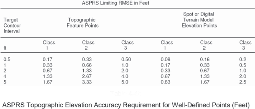
All geospatial vector data shall be submitted to the [SAMPLE AIRPORT] in [State Plane Zone (e.g., Ohio State Plane – South Zone)], North American Datum 1983 (NAD 83) (2011). Vertical coordinates shall be in reference to the North American Vertical Datum of 1988 based on the latest Geoid model published by the NGS. Horizontal and vertical units are US Survey Feet. Accuracy of these features horizontally should follow American Society of Photogrammetry and Remote Sensing (ASPRS) Planimetric Feature Coordinate Accuracy Requirements as shown in Table B-1 and vertical accuracy requirements as shown in Table B-2.
Table B-1. ASPRS standards for horizontal accuracy.
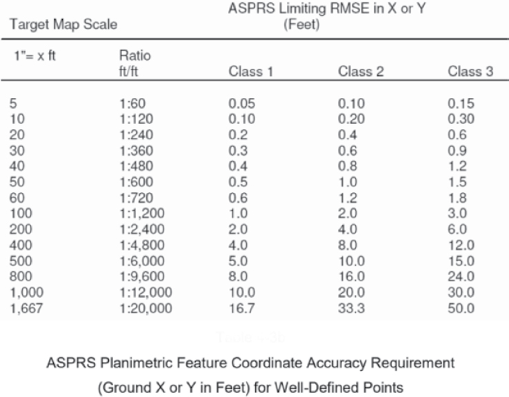
Table B-2. ASPRS standards for vertical accuracy.
References
AAS-100. Office of Airport Safety & Standards—Airport Engineering Division. 2011. Advisory Circular AC 150/5300-17C. FAA, Washington, DC. https://www.faa.gov/airports/resources/advisory_circulars/index.cfm/go/document.current/documentNumber/150_5300-17.
AAS-100. Office of Airport Safety & Standards—Airport Engineering Division. 2014. Advisory Circular AC 150/5300-18B. FAA, Washington, DC. https://www.faa.gov/regulations_policies/advisory_circulars/index.cfm/go/document.information/documentID/74204.
AAS-100. Office of Airport Safety & Standards—Airport Engineering Division. 2019. Advisory Circular AC 150/5300-16B. FAA, Washington, DC. https://www.faa.gov/airports/resources/advisory_circulars/index.cfm/go/document.current/documentNumber/150_5300-16.
National Geodetic Survey, “Publication of North American Datum of 1983” (2011) Epoch 2010.00.
National Institute of Building Sciences. 2022. United States National CAD Standard. https://www.nationalcadstandard.org/ncs6.
TSA. 2004. 49 CFR 1520. Part 1520—Protection of Sensitive Information. Washington, DC. https://www.ecfr.gov/current/title-49/part-1520.


