Geospatial Data Governance Policies and Procedures: A Guide (2025)
Chapter: 1 Introduction
CHAPTER 1
Introduction
The ability of airports to leverage spatial data for the benefit of planning, design, delivery, maintenance, and operations has never been more important than it is today. With today’s approach of “doing more with less,” efficiencies in mitigating aging infrastructure and safety and security concerns are at the forefront of many airport executives’ minds. These factors are just a few of the reasons contributing to the importance of leveraging spatial data properly. There are many efficiencies that can be gained by not only having accurate spatial data but also having effective data governance policies in place to keep the data updated and in sync with ever-changing airport facilities. For nearly 100 years, the aviation industry has been using spatial data to build, maintain, and operate airports. Although many geospatial data collection techniques and processes are capable of producing data far superior to data collected years ago, if the data is not organized and managed in a streamlined and efficient process, then efficiencies can be lost.
Historically, spatial data was only needed to represent airport assets on paper drawings, with low levels of spatial accuracy being acceptable for plotting on paper plan sheets. Electronic data management software tools have matured and now manage highly accurate spatial data. Spatial data, which previously only needed to look good on paper, is now required to have each data layer properly named, spatially accurate, and specifically constructed to be suitable for use as electronic source data. This desire to use underlying spatial features that accurately represent real-world physical assets requires a sophisticated approach to governing how data is obtained, updated, and archived over time.
Data governance is not a new concept, but airports and organizations experience inefficiencies when components of data within an organization are siloed. Data governance policies should provide guidance on how the data can be used across departments and actively prevent “siloing” of data by using only one department’s input. Consistent data governance policies are achieved by adopting policies and procedures and should involve the development of data architecture and include standards and guidelines for data storage components and data distribution.
There are many federal and private standards and guidelines that can be utilized for airports. For example, when looking at CAD standards, refer to the United States National CAD Standards (NCS) (National Institute of Building Sciences 2022). For GIS features, refer to the FAA’s schema developed in Advisory Circular (AC) 150/5300-18B-General Guidance and Specifications for Submission of Aeronautical Surveys to National Geodetic Survey (NGS): Field Data Collection and GIS Standards (AAS-100 2014). Within this guide, a comprehensive summary of issues involved in a governance program is provided, in addition to a sample geospatial data governance policy and procedure for airport geospatial data. This sample policy is intended to help an airport successfully initiate a geospatial data governance effort that can mature into a self-sustaining program. Whether referenced standards are being utilized or the sample data governance policy is being developed, it is crucial that the geospatial data governance policy be developed to meet
the requirements of the individual airport and their internal and external collaborators. It is this coordination of collaborator and user needs with available resources that makes the geospatial data governance policy most effective, regardless of airport size or resource commitment.
As important as it is to develop a sample geospatial data governance policy, it is equally important to develop a roadmap for the successful integration of a geospatial system to include GIS, CAD, BIM, and computerized maintenance management system (CMMS) components. These software programs are the core building blocks of most spatial data maintenance programs and a key part to a spatial data program foundation and roadmap. The roadmap will help establish the framework for the steps necessary to implement geospatial data governance policies and the timeframe for development, considering different scenarios for many different airport sizes and staffing levels. Step-by-step considerations are considered for each phase of the data governance development process on the roadmap, with a specialized focus on the security and privacy of data and the assignment of ownership to the program. The roadmap should include the necessary training elements and identifies tools to be developed to help airports realize the interconnectivity of the data governance program. For instance, changes in CAD standards likely impact previously developed extract, transform, and load (ETL) processes used in common data conversion routines. Having a flow diagram of the connectivity between foundational elements benefits the change management process established by the data governance policy. It also informs decision makers of the impacts from proposed changes to the published database structure (also called the database schema). It is important to understand that a geospatial data governance policy is not a static document but is intended to change and adapt as user data needs change and the technologies and tools being utilized change and adapt.
Geospatial data governance is a complex subject and must be carried out at many different levels by the supporting organization to return the most benefit. Because of this, successful geospatial data governance is often best defined by the organization implementing a data governance process specific to their needs instead of trying to adopt the standards of another organization or employ a generic template with no organizational or collaborator buy-in. The more robust geospatial data governance programs seen through this research have well-defined concepts, business processes, job descriptions, and roles. Understanding the organization’s goals and applying them to their specific geospatial data governance program is critical to the program’s overall implementation and success. Defining the program goals and objectives also includes the following types of questions:
- Who is involved?
- What data is being managed?
- When will the data be recollected and archived?
- Where will the data be stored?
- Why does this bring value to the airport?
- How will data policies and procedures be enforced to maintain the data?
1.1 Important Concepts
Geospatial data governance can represent many different ideas, depending on the person and organization defining the term. Taking the time to dissect the definition of “geospatial data governance” will inform the constructs, templates, and tools throughout this guide. Exact definitions will vary from airport to airport. The definitions in the following section explain key components of geospatial data governance and help establish a consistency in how these terms will be utilized within this guide.
Geospatial Data
In the simplest of terms, geospatial data could be defined by attaching a location to any set of data. When looking at the literal meaning of the definition further, by splitting geospatial into “geo” and “spatial,” the parts are defined as “earth” and “location.” By combining again, geospatial then becomes “earth location.” Data, in its simplest of terms, will refer to collected or created bits and pieces of information that can be manipulated and analyzed to provide details about a subject. Every airport utilizes geospatial data. While not every airport may recognize this fact, airports could not have been constructed, maintained, or improved without having geospatial data. Geospatial data has been utilized by CAD and GIS systems for years, especially regarding airside and landside features exterior to facilities. With the increased use of BIM data and the common practice of remodeling and reconfiguring interior spaces, geospatial data has become much more important to assist airports in managing their interior spaces as well.
Assets
Anything of value is an asset. An asset can be data, employees, equipment, or even something as simple as a room. With such a broad definition, assets will be explained within the guide. Most likely, an asset will be a feature or collection of features stored digitally and monitored for changes.
Data Governance
Now that the data being governed has been defined, the explanation of data governance can begin. Separating the word even further, “govern” has the meanings of control, guide, and steer while the suffix “-ance” is used as “an act of.” The pieces recombined with “data” could become the act of controlling, guiding, and steering bits of valuable details.
A more formal definition from the Data Management Association (DAMA) is “the exercise of authority, control, and shared decision-making (planning, monitoring, and enforcement) over the management of data assets” (Earley 2011, 75).
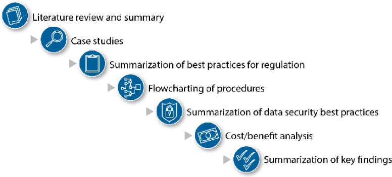
To build the recommendations found in the guide, the following steps, as shown in Figure 1-1, which were the building blocks of the guide, were completed.
1.2 Guide Structure
One of the primary purposes of this guide is to develop strategies and sample documents to help airports create their own unique geospatial data governance policies and procedures. Following the findings are appendices that provide tools, templates, and other supporting presentation material.
Additional research objectives included
- Strategies and tactics to help airports adopt geospatial data governance policies and procedures,
- A sample geospatial data governance policy,
- A roadmap for developing the policies and procedures,
- Training tools,
- An executive-level multimedia presentation, and
- A list of sample data management plans that leverage federal and industry standards.
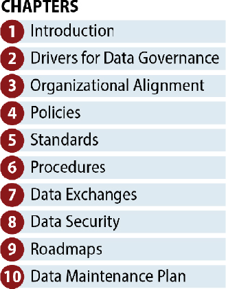
The guide has been organized to present the most fundamental information up front (“the why”), and then introduce policies, standards, and procedures that support early information (“the how”). The guide’s topics and structure are listed as follows and depicted in Figure 1-2:
- Kansas City Aviation Department (KCAD) Data Governance Strategy at Kansas City International Airport (MCI)
- Effective Practices Have Evolved Over Time at Munich Airport (MUC)
- Standards Are in Place at North Carolina Department of Transportation (NCDOT)
- Regulation Drives Focus on Long Term Investment in Data Governance That Paid Off for the Ohio Department of Transportation (ODOT)
- GIS Team Developed Procedures at San Francisco International Airport (SFO)
Appendix B: Sample Geospatial Data Governance Policy
Appendix C: Data Maintenance Procedures and Standards


