Geospatial Data Governance Policies and Procedures: A Guide (2025)
Chapter: 3 Organizational Alignment
CHAPTER 3
Organizational Alignment
3.1 Roles and Responsibilities
The choices for how to structure geospatial data governance roles and responsibilities can seem daunting. One thing for certain, however, is that leaving key roles unfilled or unrealized will ensure geospatial data governance falls by the wayside. Even if the roles and responsibilities are spread across an entire section of an organization, formalizing the duty of everyone is imperative to ensure an effective geospatial data governance program. What happens if the sole responsible party wins the lottery and leaves the airport? Will a replacement be able to pick up where the lucky lottery winner left off? Are the tasks given to each person interrupting their daily responsibilities or complementing them? Accounting for eventualities and ensuring ample time and resources are available to complete geospatial data governance tasks will help ensure a successful implementation of geospatial data governance and sustain the accomplishment.
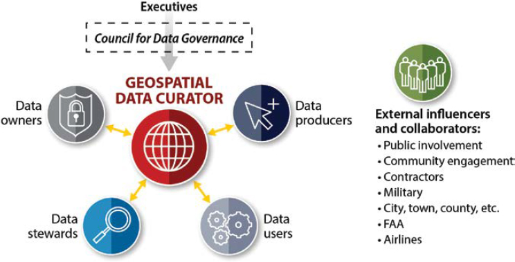
Several roles in a geospatial governance program can be defined, and it is common to have several roles combined at small airports or for organizations that have limited programs. The following roles, as depicted in Figure 3-1, and their alignment in an organization are appropriate to define and discuss:
- Geospatial data curator,
- Council for Geospatial Data Governance,
- Geospatial data owners,
- Geospatial data stewards,
- Geospatial data producers,
- Geospatial data users,
- Administration, and
- Collaborators.
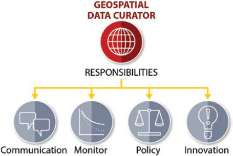
Geospatial Data Curator
The issues where geospatial data can influence decision making at an airport can be vast. Having an agreed upon set of tasks to be accomplished ensures data consistency and availability, empowers the system users, helps keep the geospatial governance program running smoothly, and adds value to the organization. The first key role in any geospatial program is that of the geospatial data curator. An oversimplification of the main role of a geospatial data curator is to keep the data healthy (up to date and accurate) and coordinate data activities. Data health factors are standardization, life cycle maintenance (update plans and depreciation), usability, accuracy, and quality. As the amount of geospatial data grows at an airport, these tasks may need to be delegated to others—such as data owners—within the organization.
Finding these geospatial curators could be as easy as finding the most active and passionate user of geospatial data within a department. A de facto geospatial data curator may already exist, but formalizing roles and responsibilities will help ensure the geospatial data is well maintained as needs change. Monitoring the amount of time spent with geospatial data health will help ensure sufficient resources are dedicated to specific governance tasks and will help to avoid curator burn-out, as some of the tasks can quickly become overwhelming with large amounts of geospatial data and covering multiple roles in addition to curator responsibilities.
Although tasks will differ depending on exactly how the role is structured, the geospatial data curator’s main role will be to make sure the data provides value to the airport. Some sample tasks for which a geospatial data curator would be responsible might be maintaining and enforcing the data standards, building a data depreciation plan that goes together with the data acquisition plan, making sure data is useful within the GIS, and massaging the data for a better fit. While collaborators themselves, curators might periodically survey other collaborators to gauge the value geospatial data is providing and make sure data is accessible and usable. Geospatial data curators are in the key position to fix other collaborators’ problems with the data while also making sure collaborators are seeing the ROI from GIS.
The success of a GIS at an airport can rely heavily on the geospatial data curator. A small airport may have only one software license for years and, acting as a de facto geospatial data curator along with several other roles, one geospatial champion can grow the need for geospatial data to the point that the airport may need to add a second and third license.
Along with geospatial data curators, there are also geospatial data owners, data stewards, data users, and data producers. Geospatial data curators may accomplish, or have a great amount of influence, over these additional roles. Alternatively, there may be multiple people from multiple departments in each role. No matter how the airport chooses to structure geospatial data governance, the most crucial factor is delineating the roles and then communicating with responsible parties. Different departments have different needs, and if they are not intentional about discussing geospatial data considerations, the likelihood of duplicate labor increases. For example, a project completed for planning is likely to have a more lenient level of accuracy than one completed for an engineering design group. For projects completed for planning, numerous projects have been recollected at the same airport but use higher accuracy standards because the design group needs the same data to a higher degree of detail and accuracy. Looking to the roles and how they interact, they may seem similar at first; however, these roles can have different responsibilities. Airports should consider these roles to help facilitate communication about geospatial data governance and avoid duplicate data collections. If the staff for four positions is not present,
consider the job descriptions and how two people could accomplish these tasks. It is advisable to have a minimum of two people so independent quality control (QC) tasks can be completed when data is being produced.
Responsibilities
The geospatial data curator is a member or facilitator of the Council for Geospatial Data Governance whose responsibilities, as shown in Figure 3-2, are to
- Foster communication;
- Monitor geospatial data health;
- Enforce policy, standards, and procedures; and
- Innovate new geospatial data use cases.
Council for Geospatial Data Governance
One effective way to help break down data silos is to develop a forum for all parties to discuss geospatial data governance. Establishing a council for geospatial data governance is imperative to the success of a long-term geospatial data governance program. The geospatial data governance council is made up of the data governance officer and the geospatial data curators. Establishing a process for how often the council meets, choosing backup geospatial data curators (when one member is not available), and keeping meeting minutes with tracked actionable items are all important components and processes of the data governance council.
Empowering a single user from each department at a large or medium airport may be one way to start a geospatial data governance council. However, it is important that inclusivity be somewhat selective, because too many committee members can decrease a committee’s effectiveness. Keeping one single representative for each functional area helps ensure they represent the final chosen decisions back to their departments and teams. Although a small airport may not have a geospatial data governance council, a curator and their supervisor can act as a council, and the additional involvement of consultants can help fulfill the council responsibilities.
A geospatial data governance council would be responsible for reviewing standards, policies, procedures, communications, and training protocols at regular intervals. They would drive data maintenance discussions (when to depreciate, how often to recollect, etc.) and set priorities for new data sets. It is suggested that both decision makers and technical staff should be a part of the council to ensure decisions can be made with technical competence and confidence that council decisions benefit the overall organization, not just a few collaborator concerns. With this collective knowledge, a geospatial data governance council is best positioned to evaluate the ROI in new data sets and help ensure proper policies and procedures are followed to result in good data health.
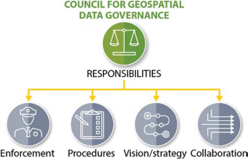
Responsibilities
Geospatial data governance council responsibilities, as presented in Figure 3-3, are to
- Review and approve polices, standards, and procedures;
- Establish new data prioritization;
- Set archiving timeframes;
- Hold meetings at set intervals;
- Establish vision and strategy for the airport’s data governance initiatives;
- Monitor the overall progress of the governance program; and
- Coordinate with information technology (IT) staff for any items that may need to be escalated (i.e., budget/finance, storage needs, licensing, etc.).
Geospatial Data Owners
As effective managers of geospatial data within their functional area, a geospatial data owner is going to oversee the health of the data. These owners may be like champions in the sense that they might be responsible for finding funding and technical staff. They are more likely to be involved in the geospatial data processing at a small airport but likely delegating it at a medium or large airport. Geospatial data owners could serve as excellent points of contact for data coming in from contractors and consultants. At medium or large airports, there may be one data owner assigned from each major department or functional area.
The roles and responsibilities of geospatial data owners may consist of championing an update for their data based on recent issues with the geospatial data set. As keepers of their data, they are well positioned to suggest ways to improve practices. They might also author a new policy or procedure to eradicate a systematic error impacting their data. Geospatial data owners may be part of the geospatial data governance council, but if not, they should have a way to update the geospatial data governance council regularly about the status of their data sets as well as the impact it is having on the airport.

Responsibilities
Geospatial data owner responsibilities, as shown in Figure 3-4, are to
- Champion all things geospatial (e.g., funding, technical staff, resources),
- Make continuous improvements,
- Have decision-making authority on access to their data,
- Report on impacts, and
- Serve as optional members of the Council for Geospatial Data Governance.
Geospatial Data Stewards
Geospatial data needs proper care to maintain its value. The geospatial data steward’s realm would include QC, with the caveat that QC checks are to be performed by persons other than the creator of that data. While adjacent to geospatial data owners, they might be doing more behind-the-scenes work and cleanup. The archival process could fall into their hands, as could assisting in the development of policies and processes.
Geospatial data stewards are likely the go-between for owners and producers or users. As such, they may be more likely to see updates necessary within the standards or policies and to be the intermediaries to help the producers and users communicate on these updates. A steward might mitigate conflicts between administration (owners) and operation (producers and users) if any occur. Since producers might be external to an airport, the geospatial data stewards may transition geospatial data from the producer to the internal system, ensuring that nothing breaks in the process. The archiving plan and process would fall into their hands. Although this position is easily consumed by the data owners and data producers, ensuring these tasks are accomplished is imperative.
Responsibilities

As shown in Figure 3-5, the responsibilities of geospatial data stewards are to
- Mitigate conflicts,
- Transition geospatial data from testing to production,
- Archive old data,
- QC data,
- Assist with determining rights on access to their data,
- Identify and resolve data issues and conflicts, and
- Serve as optional members of the Council for Geospatial Data Governance.
Geospatial Data Producers
Pivotal to geospatial data governance, geospatial data producers may be contractors acquiring geospatial data, surveying the latest addition to the airfield, or compiling the geospatial data into a geodatabase with the correct fields. This is a spot for quality assurance (QA) to be completed, but likely not QC unless there are multiple data producers, and an independent review can be done by someone who did not produce the data. Additionally, if geospatial assets are coming in from external sources, it is important that geospatial data is reviewed before being incorporated into any internal system.
By creating new data through collection or combination, a geospatial data producer is arguably the most important role. Without a producer, users do not have data to manipulate, and owners do not have a data set to own. The responsibilities of a data producer, however, can vary drastically based on the data being produced and whether the data producer is internal or external to the airport. As creators, one of the most important roles for them is to follow the policies, procedures, and standards in place. While others may be doing QC checks, geospatial data producers should always quality assess their work before introducing it to anyone else. These checks could be built into their production processes or a separate process that occurs before QC is performed.

Responsibilities
Geospatial data producer responsibilities, as shown in Figure 3-6 are to
- Create geospatial data;
- Conduct QA;
- Comply with policy, standards, and procedures; and
- Serve as optional members of the Council for Geospatial Data Governance.
Geospatial Data Users
While likely uninvolved in how the geospatial data is produced, the geospatial data users have one of the most important roles in an organization. Everyone else’s jobs are to support the geospatial data users. While a geospatial data user may be doing little day-to-day tasks on maintaining or creating geospatial data, they are pivotal for providing feedback on data being created. If a standard is missed, a field name is incorrect, or the geodata is mistakenly projected using the wrong units, the geospatial data users are going to be the ones whose processes break. For this reason, geospatial data users are relied on for improving quality checks, maintenance procedures, and standards.
The responsibilities of a geospatial data user may seem minimal. This trivial nature of the responsibilities of geospatial data users is amplified by the fact that it is entirely possible to consider all other roles as geospatial data users. Even though the responsibilities may seem slight, their impact on the organization is of grave importance to geospatial data governance. Geospatial data users should report any issues they see to the rest of the organization. Sharing use cases helps to ensure the data continues to be maintained and updated. Although it seems intuitive, geospatial data users may not realize how important it is for them to speak up with their needs or issues. Empowering them as valued collaborators is key to successful geospatial data governance. Again, these responsibilities need to be realized even when the geospatial data user is the data owner, such as is the case at many small airports. Often, although geospatial data is crucial to an operation at an airport, those who work with the data every day take for granted that everyone else also sees that criticality. Without users of geospatial data, why would geospatial data and a governance policy be needed? Along with a reason for geospatial data governance, geospatial data users are the first line of defense against bad data, as they are the first to spot problems that may have crept through QC measures.
Responsibilities
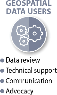
Geospatial data user responsibilities (Figure 3-7) include
- Ensure data is created in compliance with related policies, standards, and processes;
- Provide technical support;
- Enable change management and communicate necessary changes; and
- Celebrate the usefulness of geospatial data and advocate for needs.
Collaborators
Collaborators can be defined as anyone with an interest or concern in something. Figure 3-1 showed some common collaborators in the airport industry. Examples include the public, local municipalities, the FAA, and airlines. Collaborators can also be internal (anyone dealing with geospatial data or impacted by changes to geospatial data) and external (contractors and consultants). All play a role in geospatial data governance, but the preferences of internal collaborators would likely trump external collaborators in most situations.
The creation of data without a use is an exercise in futility. Without data users, the geospatial data does not need to exist. Providing users what they need in the format that works best is crucial. Keeping collaborators satisfied has the potential to help grow the use of geospatial data further. Satisfied collaborators are more invested in the success of the geospatial data program. Collaborators are the best source for ROI on geospatial data.
Proactive Outreach to Data Users
If airport staff are unaware of the existence and power of geospatial data, they will not use it. Some may also have to be convinced that geospatial data has value by demonstrating a positive ROI. Realizing that geospatial data can help decision makers at an airport might mean looking at issues that may not initially be obvious. This is often described as looking for the low-hanging fruit and finding something that provides an immediate win to the airport. At many airport organizations, a quick win is their daily operations procedures for a certificated Part 139 airport, which require that a minimum of two inspections be completed daily. By having a geospatial data curator become familiar with this process and having the data outlined into a format that benefits the airport operations team, a host of benefits can be realized. This includes more efficient operations, better tracking of work orders, better coordination with the FAA through enhanced reports and dashboards, development of asset maintenance history by location, and more. Getting a small win such as this with the operations team and getting them to communicate with other departments and show the benefits realized can provide proactive outreach. There is no better sales model than a good reputation with word of mouth coming from clients. When airports treat each department as a client, they can realize the benefits of this outreach.
Communication and Training Protocols
Education of staff on the organization’s geospatial data governance program and training is a critical step. Training is the responsibility of all collaborators—both in participation and continuing education. This education benefits all collaborators because the more people who comprehend the value of geospatial data governance, a greater number of people will assist in geospatial data governance tasks. While internal training can take place at regular intervals, external training of consultants and contractors is traditionally the contractor or consultants’ responsibility. However, a contractor or consultant may position themselves very well with the organization for future work if they can show an understanding of the organization’s geospatial data governance goals and the ability to deliver within the defined standards and specifications. Geospatial technologies and data governance methodologies change rapidly and as such, standards and software technologies are continually evolving. An organization that creates a robust and dynamic training program and continually adapts it to these changes will ensure long-term success. Purposeful and immediate communication of changes and the distribution of updated policies, standards, procedures, and training programs as they are adapted can be part of a data governance council’s responsibilities.
3.2 Summary
Accountability is a critical component of geospatial data governance. Defining the roles but also empowering the personnel within those roles to reject or require rework of data is critical to the long-term success of a geospatial data governance program. Data costs money, whether it is the time to maintain it or the cost of collecting it. One of the biggest pitfalls discussed with airports throughout this research has been the inability to enforce standards both internally and externally. It may be a department that is not bought in at an airport or a contractor who refuses to follow the standards provided. In either instance, the long-term ramifications of not enforcing these standards could undermine the entire geospatial data governance program.


