Geospatial Data Governance Policies and Procedures: A Guide (2025)
Chapter: Appendix C: Data Maintenance Procedures and Standards
APPENDIX C
Data Maintenance Procedures and Standards
Geospatial Data Maintenance Needs
As part of developing a set of geospatial data for [SAMPLE AIRPORT], the airport desires to also create a repeatable data maintenance process so that new projects contribute to overall airport data and data is frequently maintained as the airport configuration changes. FAA Grant Assurances and Regulations require airports that receive federal funding for planning and development projects to also submit properly formatted geospatial data developed for the project to the FAA Airports Data Information Portal (ADIP) website.
Data will be housed in the [SAMPLE AIRPORT] asset registry and will need to be maintained and updated for FAA compliance and airport use.
Governing Specifications
Specifications for this geospatial data is documented in the following FAA ACs:
- AC 150/5300-16B—General Guidance and Specifications for Aeronautical Surveys: Establishment of Geodetic Control and Submission to the NGS (AAS-100 2019).
- AC 150/5300-17C—Standards for Using Remote Sensing Technologies in Airport Surveys (AAS-100 2011).
- AC 150/5300-18B—General Guidance and Specifications for Submission of Aeronautical Surveys to NGS: Field Data Collection and GIS Standards (AAS-100 2014).
The national BIM standard is also applicable. In its most basic form, BIM helps produce a 3D model of a facility. However, BIM is much more than just a standard for 3D building data. BIM standards define digital, object-based, and interoperable building information and modeling processes and tools.
As defined in the original NBIMS document, BIM is “a digital representation of physical and functional characteristics of a facility. As such, it serves as a shared knowledge resource for information about a facility forming a reliable basis for decisions during its lifecycle from inception onward.” If implemented properly, nearly every piece of information that an owner needs about a facility throughout its life can be made available electronically through BIM data.
A goal of the National Institute of Building Sciences BIM Council (formerly buildingSMART alliance) is to establish, through the NBIMS-US Project, the standards needed to foster innovation in processes and infrastructure so that end-users throughout all facets of the industry can efficiently access the information needed to create and operate optimized facilities.
Objectives
Data maintenance procedures should be established to define the steps and best practices that individuals assigned to geospatial data maintenance shall follow. Carrying out these procedures, defined generally in this document, will ensure that geospatial data is maintained at a high-quality level.
FAA ACs have established quality standards for the data and features defined within them. However, [SAMPLE AIRPORT], may have data requirements beyond the needs of the FAA, and the accuracy specifications within the standards and policies of [SAMPLE AIRPORT] should be followed. Maintaining the geospatial data to specifications is critical to preserving the high quality of the data and maintaining compliance with FAA requirements and [SAMPLE AIRPORT] use cases. Properly maintained geospatial data will offer a high degree of accuracy and completeness to the end users, supporting their decision making and adding significant value to airport business processes through having accurate and available data.
Factors Affecting Data Maintenance Needs
The objective of geospatial data is to depict the current configuration of infrastructure, facilities, assets, property, and planned features (where applicable). Depictions of airport configuration include land both on and off airport property, buildings and other structures, leased space, major pieces of equipment, three-dimensional airspace boundaries, underground utilities, etc. In an airport environment, the physical configuration and location of these elements can change over time—some frequently and others only rarely.
Geospatial data maintenance procedures are necessary to track changes to these elements and make requisite adjustments to the asset registry so that the geospatial data remains current with the physical environment it is meant to depict. This evolution of geospatial data is shown in Figure C-1.
In general, there are four phases of the geospatial data maintenance life cycle, as shown in Figure C-1. These phases are Change Tracking (Steps 1 and 2), Data Creation (Steps 3, 4, and 5),
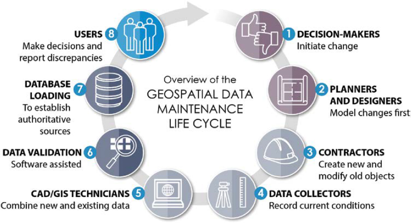
Database Updates (Steps 6 and 7), and GIS Use (Step 8). The detailed activities in each of these four phases of the data maintenance described in the rest of this section.
- Change tracking monitors any activity that can alter the physical configuration of infrastructure, facilities, assets, and property relevant to the airport. This kind of activity includes construction undertaken by the airport in the form of a capital improvement plan (CIP) and smaller initiatives carried out under work request processes. Activities that warrant change tracking also include projects undertaken by tenants, the city/municipality or county, utility providers, and other entities outside of the airport but affecting airport infrastructure. These drivers of physical change must be monitored so changes required to the geospatial data can be identified before they occur; furthermore, tracking will ensure external data deliverables will be prepared to facilitate geospatial data maintenance. Finally, drivers of changes should be monitored so geospatial data producers will be available to make the necessary changes to the data warehouse when the deliverables are received. This proactive approach of identifying data changes as early as possible is critical to timely data maintenance.
- Data creation encompasses the activities that produce new data: designs, drawings, measurements, and coordinates collected in the field (both inside and outside of buildings), and data that is remotely sensed (collected without coming into physical contact with changed features), such as with aerial photography. Typically, this work will be carried out by consultants, contractors, and data vendors, but, in some cases, airport staff will take measurements and collect geospatial data in the field themselves.
- Database update covers the steps to process the data collected in the field and load it into the data warehouse. Geospatial data producers will be responsible for updating the geometry and attributes that reflect the new conditions. They are also responsible for recording metadata to describe the changes they have made and for performing quality assurance on the data before it is submitted. The geospatial data producer must also verify that the new data is compliant with FAA airport GIS data standards and specifications before the data is transferred to the FAA or the airport’s database for users to access.
- GIS use includes using the geospatial data portal and other data products (or eventually even other integrated computer systems) that may link to the data warehouse and the extraction of hardcopy maps, reports, or electronic data. This is the final phase of the data maintenance life cycle, but it also presents new changes and prompts a new iteration of the data maintenance cycle. Specifically, if end users notice discrepancies between the data and current conditions in the field, they will be asked to report these discrepancies so that updates can be made to the data. Geospatial data will also be utilized at the beginning of design and construction projects and will be modified to create new data that must be entered into the data warehouse at project completion and submitted to the FAA ADIP. A significant element in the data use area that is often overlooked when focusing strictly on how data changes is that geospatial data is often used in printed map form and as the electronic basis for future changes. It is anticipated that the production and use of printed maps or electronic data transfer for future design work will be as significant as the effort needed to maintain the airport geospatial data.
GIS Data Creation Rules
Geospatial data intended to be loaded into the airport data warehouse must be consistent with these airport data creation rules described in this section.
Field Data Collection
Field data collection is one data creation method for development of new geospatial data or maintenance of existing geospatial data. Consultants, contractors, and other parties may conduct fieldwork on behalf of the airport to develop airport data. The following steps are to be performed
by contractors or airport staff (collectively referred to as “Geospatial Data Producer”) when developing geospatial data from field observations. The Geospatial Data Curator will coordinate all geospatial data collection conducted by the airport. Whether data collection is to be performed outside or inside of buildings will dictate what processes and equipment the Geospatial Data Producer should use.
The Geospatial Data Producer will choose a data collection device that corresponds to the type of data to be collected, the accuracies required, and accessibility of the features being recorded. For exterior work, redlining on hardcopy or electronic maps, survey-grade real-time kinematic (RTK) GPS units may be selected. For interior data collection, redlining on hardcopy or electronic maps or electronic measuring devices (such as a distometer laser measuring device or lidar scanner) may be selected. Regardless of where the data is to be collected or the type of data collection method/device the Geospatial Data Producer plans to use, the next step is to download or print existing information.
For exterior data collection, the Geospatial Data Producer should make redline annotations to hardcopy or electronic maps used for exterior data collection to record observations in the field. Hardcopy redlines used for exterior data collection should be transposed into an electronic format by the Geospatial Data Producer once they have returned from the field. Points, along with any associated attributes and metadata, should be recorded in the field. Points captured using GPS may need to be post-processed to obtain the desired accuracies. For interior data collection, the Geospatial Data Producer should make redline annotations to hardcopy or electronic maps used for interior data collection to record observations in the field.
Hardcopy redlines used for interior data collection should be transposed into an electronic format by the Geospatial Data Producer once they have returned from the field. Interior measurements may be taken using measuring tape or electronic devices. The next step, regardless of how field data is collected, is to convert the information into a format that can be used within the data warehouse to support geometry and attribute data maintenance. Data collected in the field should be checked by reviewing error statistics from GPS equipment, randomly tested against another source of equal or higher accuracy, compared with high-resolution orthophotos, and through other means.
Electronic Data Creation
The following steps describe how new data that is collected should be assessed and prioritized for incorporation into the data warehouse. These assessment procedures evaluate the quality of the new data in comparison with the current data. Quality is assessed based on the accuracy, correctness, comprehensiveness, and other factors. Where the new data is determined to be of higher quality than data currently in the data warehouse, this assessment will help prioritize the efforts required to clean up, convert, and properly load it into the data warehouse.
The first step in data assessment is to review any metadata that may have been provided with the source data. If no formal metadata (e.g., metadata saved within a data warehouse or as an XML component) is provided, information including transmittal letters, labels, “readme” files on the media and other supporting documentation should be reviewed. If this information is still insufficient, then the person who provided the data should be contacted for further details.
The metadata should be checked for temporal accuracy (i.e., how current it is). If the data is determined to be newer than data in the data warehouse, then it may be of use. The data should be checked for positional accuracy (i.e., how close it is to the feature’s true position). If the data is determined to be more accurate than data in the data warehouse, then it may be of use. The data should be examined to determine the physical extent of the data to ensure that it is relevant to the airport.
If the metadata indicated that the data may be relevant based on its temporal and positional accuracies and its extent, then the data should be examined. The positional accuracy should be checked to ensure that the data is more accurate than what is already in the data warehouse. This time, the data should be checked against a source of known higher accuracy such as existing survey control data, planimetric features derived from orthophotos, or data specifically collected in the field to test the positional accuracy. The data should also be examined to ensure that it is complete based on the defined data extent. The Geospatial Data Producer should summarize the results of the assessment of the data set and convey them to the Geospatial Data Curator.
Data Created During Design and Construction
All projects, whether carried out by the airport through capital improvements, tenant improvement, or maintenance activities, will be tracked by the Geospatial Data Curator. Preliminary design processes will collect available data and add, modify, and remove features to reflect a new design concept. At the end of the preliminary design phase when design is considered 30%, 60%, and 90% complete, this new data will be checked to ensure it conforms to the airport standards.
During construction, redlines will be made on 100% design drawings to indicate changes made during construction. Fieldwork may also be conducted to capture data while features are exposed by construction, such as new utility structures that will be covered by earth. Whether through redlines or through fieldwork prompted by construction, construction activity is an important source of new data that will drive geometry and/or attribute changes to the data warehouse.
Following construction, but before a facility is commissioned for use, an inspection and certification process shall be carried out, which can yield additional redlines on design drawings and possibly additional fieldwork.
Data Created from Aerial Photography
The periodic update of orthophotos and resulting planimetric features is another process that creates geospatial information for the airport and drives geometry and/or attribute changes to the data warehouse. In the future, other remote sensing means such as lidar and satellite imagery may follow a similar data creation process.
The airport shall periodically obtain new orthoimagery and derive updated planimetric features through the planimetric development process using 3D stereo image compilation. Geospatial features should not be digitized directly from orthophotos as the 3D stereo imagery has greater spatial accuracy. Mixing features compiled from stereo imagery with hand-digitized features from orthoimagery will degrade the spatial accuracy of the airport features.
Geometry Maintenance
This section describes procedures that should be followed to update geometric data features. This section also describes procedures that may be necessary to clean up geospatial data before it can be converted into a GIS. Steps for correcting undershoots/overshoots, closing polygons, finding and resolving slivers, and correcting topology are identified in this section. Each software user manual can provide details and processes for using the software to carry out the procedures in this section. These procedures are to be carried out by the Geospatial Data Producer or contractor staff at their direction.
The data creation process will produce data from a variety of sources. Data will be produced by external sources such as consultants and contractors, the airport, other governmental agencies, third-party data vendors and others. The Geospatial Data Curator will be responsible for collecting and distributing this data to those who need it. The periodic update of orthophotos and resulting
planimetrics carried out by the airport is an important source of wholesale feature data updates. Geospatial Data Producers will also record a variety of data in the field. Finally, other divisions may report discrepancies between existing data and current conditions in the field. Sometimes, these discrepancies may prompt further fieldwork to investigate and resolve any discrepancies between the geospatial data and the actual field conditions.
Regardless of the source of the data to be used for data maintenance, the Geospatial Data Producer will first determine if this data complies with the airport’s standards. In most cases, data will be coming from the airport staff or consultants and must comply with the standards. In cases where data is coming from third-party vendors, municipalities, or other sources, compliance with airport standards may not be required.
The next step is for the Geospatial Data Producer to determine what type of data has been received. CAD data may need to be converted into a format compatible for loading into a GIS, or vice versa. Survey data also may need to be converted into a format that can be edited and prepared for loading. Many formats such as Comma Separated Value (CSV) coordinates and Coordinate Geometry (COGO) files can be read directly by GIS and CAD software. Other formats, such as LandXML, may require conversion.
With all incoming data in a format that can be edited in the airport, the Geospatial Data Producer should determine if the new data is expressed in ground- or grid-based coordinates. Although the airport standards may require data in grid-based coordinates, some data may be submitted by sources that do not have to adhere to these standards and may be in ground-based coordinates or a local assumed coordinate system. In many cases, metadata will be provided that will indicate which coordinate system was used. In other cases, features in the incoming data may have to be compared with the same features in a known coordinate system.
If the incoming data has been determined to be in ground-based coordinates, the ground/grid scale factor must be applied using the appropriate coordinate transformation functions. If the incoming data has been determined to be in a local assumed coordinate system, the ground/grid scale factor must be applied using the appropriate coordinate transformation functions and the data will need to be translated using common features.
The Geospatial Data Producer then loads the data into a location where a working copy should be created for evaluation, leaving the original undisturbed. Software data management tools may also facilitate creation of an “edit” version of the data. The Geospatial Data Producer can then begin the process of reviewing the incoming data to determine what changes need to be made to the data warehouse. In many cases, the new data will contain new features that do not exist in the data warehouse and must be added.
The Geospatial Data Producer may find that new features, created by others, must be cleaned before being added to the data warehouse. Following are the typical types of issues that will need to be cleaned from new data sets:
- Polygons may not be closed. In these cases, polygons should be closed by snapping two existing vertices together or by adding a new line segment that closes the gap. If the polygon is not closed, it will not be represented as a polygon and will need to be closed for loading into the data warehouse.
- Polylines may need to be manipulated so that each polyline or line segment connects to adjacent nodes (typically shown as point features).
- Polygons that fall below a logical size limit may have been created as an anomaly in the data creation process and may need to be removed.
- Vertices of polygons and lines should be sufficient to achieve the desired accuracy. Additional vertices that do not provide clarity to the data could be removed using various software tools.
In some cases, incoming data may be modifications to existing features. Depending on the nature of the change required, the Geospatial Data Producer may decide to archive the existing feature, adjust the existing feature, or bring the modified feature in as a new feature, the latter of which would only be used when the existing data is substantially older than the new data or when the feature’s geometry has changed significantly enough that it is easier to bring the modified feature in as new and delete the feature that it is replacing. Alternatively, the Geospatial Data Producer may simply make edits to the geometry of the existing feature. The data warehouse should be designed so that most features have a “status” attribute that will permit archiving of demolished facilities easier to accomplish by changing the state of the status attribute.
New and modified features may also require topology to be adjusted. Following are the typical types of topology issues that will need to be corrected. Diagrams of such topological relationships can be found in FAA AC 150/5300-18B, as follows:
- Polygons may overlap each other. In some cases, overlaps are not allowed (e.g., runway element). In these cases, polygon edges should be adjusted to remove the overlap and vertices of features should be snapped to corresponding vertices of adjacent features.
- Polygons may have slivers of unaccounted space between them. In these cases, polygon edges should be adjusted to remove the gap and vertices of features should be snapped to corresponding vertices of adjacent features.
- Line overshoots may need to be trimmed so that line segments end at a node, endpoint, or point of intersection as appropriate.
- Line undershoots may need to be extended so that line segments end at a node, endpoint, or point of intersection as appropriate.
- Vertices of features should be snapped to corresponding vertices of adjacent features.
New or modified features may also require attributes to be edited. New or modified features will also require metadata to be entered. Geospatial Data Producers may need to perform actions to remove a feature from the data warehouse. No significant features should permanently be deleted. Depending on the data warehouse design, features can remain as is with a status attribute change or moved to an archive of removed features.
The Geospatial Data Producer should conduct QA of their work throughout the geometry maintenance process, especially when removing parts of features and inserting new parts—remember to join the parts into a “whole” feature. This QA should include reviewing their work for polygons that are not closed, overlapping polygons, slivers between polygons, improperly placed vertices, and overshoots and undershoots. These can be checked by zooming and panning to areas of the map that have been edited and visually checking for issues.
Once the Geospatial Data Producer has added new features, modified changed features, and/ or archived/removed features, they should perform QC on the data first by checking the features against other layers or related layers, and then by having another qualified technician conduct an independent review. If the data does not pass QC, then the Geospatial Data Producer must clean and adjust topology as necessary.
After geometry (and attribute) editing and passing QC, the data can be updated to the GIS production environment as appropriate.
CAD Data Preparation and Conversion
Preparing CAD data that is compliant with the airport CAD standards is not only a requirement of CAD data submitted to or prepared by the airport, but it is an important prerequisite to updating the primary data warehouse where CAD data is the original source. The procedure and
specifications for preparing compliant CAD data are described in the CAD standards. Existing CAD data sources or CAD data that is not prepared by the airport staff or consultants will not conform to the airport CAD standards. In these cases, CAD data may need to be manipulated by the Geospatial Data Producer before it can be incorporated into the airport’s data warehouse.
CAD Preparation and Conversion Steps
Where applicable, check for compliance with the airport’s data standards. Each CAD, DWG, or DGN file should be checked to ensure that it can be opened in the correct version of Autodesk AutoCAD or Bentley’s MicroStation, respectively. The model space of each CAD drawing should be checked to ensure that it is in the proper geographic coordinate space. This can be accomplished by checking the drawing coordinates of at least two points shown in the CAD drawing against the true known coordinates for those points. Control stations, for which high accuracy coordinates are known, are recommended for this purpose.
The Geospatial Data Producer should randomly check a representative sample of layers which will be used for feature creation, modification, or archived to ensure that the proper geometry and type of features are on each layer.
Depending on the type of data and the number of similar CAD files to import, the Geospatial Data Producer may decide to use software tools to convert the CAD data into a data warehouse format. FME or other data conversion software could be considered in the following cases:
- CAD files to be converted contain a large number of layers for which there are many CAD layers that are to be combined into a single GIS layer with an attribute (typically a type code) that distinguishes between them. FME’s workbench can be used to read the layers in the CAD file, and they can be graphically matched with the corresponding layer(s) of the GIS. The separation of features on different CAD layers can be used to set an attribute in the GIS file.
- Multiple CAD files are submitted with the same layers but for different geographic areas. An example of this is when sections of a building are split into separate files with match lines to align the data. FME Workbench can be used to create a translation file that the Geospatial Data Producer can save and reuse for each CAD file of the same structure.
- CAD files are submitted as part of a long-term project where future submittals are likely to require the same layer manipulation. FME Workbench can be used to create a translation file that the Geospatial Data Producer can save and reuse for future CAD files of the same structure.
The technician should then bring the data from the CAD file or from the file(s) created by FME into the data warehouse for manipulation and editing. The geometry maintenance procedures should now be carried out with the CAD data.
Attribute Data Maintenance
This procedure describes methods for the entry, cleanup, conversion and loading of alphanumeric data that, in some cases, is maintained separately from the corresponding geometry in a data set. This procedure covers text that is manually entered and text that is loaded from electronic files—it does not include procedures for transferring data from other systems.
Attribute Data Maintenance Steps
The data creation process will produce attributes that are usually entered by Geospatial Data Producers or external data providers and then collected by the Geospatial Data Curator. Attributes will also be produced through field data collection activities. This field data collection will be coordinated by the Geospatial Data Curator. The first step in the attribute maintenance
process is for the Geospatial Data Producer to determine the format of the attribute data to be entered into the GIS. Viable attribute formats can include hardcopy data, spreadsheets (e.g., Microsoft Excel), personal databases (e.g., Microsoft Access), and comma delimited text files.
Attribute data provided in a hardcopy format will need to be manually entered into the attribute table for the appropriate feature class within GIS. In some cases where a large number of attributes are to be entered, the Geospatial Data Producer may decide to enter the data into another format such as a Microsoft Excel spreadsheet, which can allow long lists of data to be more easily copied and checked, then joined to the appropriate feature table.
Attribute data provided in tabular electronic format such as a Microsoft Excel spreadsheet, Microsoft Access database, or CSV ASCII file can often be linked with features in a spatial data set. For this to work, the feature class and the external tabular data to be joined need to share a common unique identifier. This can be achieved by exporting attribute data including such an identifier from the feature class first and then using this exported file for subsequent data entry. When the external data is joined to the feature class, the joined attributes are not saved into the feature class directly, but they can be copied into the desired attribute fields.
In some cases, attributes may be provided in GIS or CAD files in a manner that can be converted to the appropriate attributes in the data warehouse. Tools such as FME Workbench and others can help in such conversion. For example, GIS files may contain fields that need to be concatenated or edited before being compliant with the GIS Spatial Data Standards Specification. With CAD data, attributes can be attached to blocks or as object data. In some cases, tools such as FME can be used to convert these attributes into a format that can be read by the GIS.
After attributes are entered, metadata should be adjusted as necessary to reflect the changed entries. Metadata changes may include the source of the revisions, the date the edits were made and any notes regarding cleanup or conversion steps that may have been used to alter the data.
QA should be completed on all modified data sets once the modifications are completed by the Geospatial Data Producer. After all modifications have passed QA, the Geospatial Data Producer should post the new data to the production data warehouse.
GIS Data QC, QA, and Validation Procedures
This section describes QC, QA, and validation procedures that are to be applied to data that is to be loaded into the GIS. These procedures include those that the airport personnel responsible for data maintenance should use as data is being maintained. Consultants and contractors that develop data for the GIS should also be encouraged to use these procedures to ensure data will pass the airport QC checks. The procedures in this section also include steps that the staff should use to check contractor data submittals against the data standards and specifications before it is loaded into the data warehouse. Finally, the process for carrying out annual audits to check data in the data warehouse is described.
QC Procedures
The procedures that data maintainers should use to establish quality as they develop and maintain data are described in this section. These procedures are mainly defined for the airport staff responsible for data maintenance, but consultants and contractors should be encouraged to use them as well. Consultants and contractors cannot be mandated to use these procedures as they may have designed procedures specific to their business process.
As geometric data is created, it should be checked for spatial accuracy. This is especially the case if data is being created based on source data that is converted from another coordinate
system such as ground coordinates. Data can be checked for accuracy by comparing it with a source of similar data that is known to be of higher quality. Two sources that can provide such information, depending on the expected quality of the data being checked, are the planimetric data provided as a result of the orthophoto development process or fieldwork to collect high-accuracy coordinates.
As features are created, edited, or archived, the Geospatial Data Producer should check to ensure that all pertinent features are properly handled. There are several ways this can be done depending on the data. A query to indicate the number of features edited can be executed and compared with the number of features in the source data set. A visual review of the physical extent of the area being edited can be conducted. Edited features can be overlaid on top of aerial photography or features from the data warehouse to ensure all expected features have been edited. In some cases, field verification of the data may be warranted.
All features created or edited should be checked for conformance to the appropriate geometric rules. Although these will vary between feature classes, the following general rules apply to all based on their geometry type:
- Polygons may not be closed. In these cases, polygons should be closed by snapping two existing vertices together or by adding a new line segment that closes the gap.
- Polylines may need to be dissolved so that each polyline or line segment connects to adjacent nodes (typically shown as point features).
- Polygons that fall below a logical size limit may have been created as an anomaly in the data creation process and may need to be removed.
- Line segments and polylines may need to be merged so that each polyline or line segment connects to adjacent nodes (typically shown as point features).
- Vertices of polygons and lines should be sufficient to achieve the desired accuracy. Additional vertices that do not provide clarity to the data should be removed.
All features created or edited should be checked for conformance to the appropriate topology rules. Although some rules are specific to individual feature classes, the following rules apply to all:
- Polygons may overlap each other in cases where overlaps are not allowed (e.g., lease lines). In these cases, polygon edges should be adjusted to remove the overlap.
- Polygons may have slivers of unaccounted space between them. In these cases, polygon edges should be adjusted to close the gap.
- Line overshoots may need to be trimmed so that line segments end at a node, endpoint, or point of intersection as appropriate.
- Line undershoots may need to be extended so that line segments end at a node, endpoint, or point of intersection as appropriate.
- Vertices of features should be snapped to corresponding vertices of adjacent features.
As attributes are entered, they should be checked for correctness against the source data and conformity with the format and rules relevant to each attribute. For example, all numbers should be checked to include only numeric values, positive values should be positive, dates should be valid dates, etc. Software validation routines will check for many of these issues, but manual QC should also be performed. One method of doing this is to sort attributes in a table and examine the results for outliers. The Esri “frequency” tool is also useful for examining similarly attributed features for possible attribution errors.
Metadata should also be checked in much the same manner as attributes are checked. The Geospatial Data Producer should proofread all narrative and explanatory text in the metadata to ensure that it is logical and does not contain grammatical or typographical errors.
Quality Assurance and Validation Procedures
The procedures described in this section are procedures that must be performed before the airport staff submits data for consumption by others or into the production data warehouse. Consultants and contractors may be contractually required to use these procedures, or they may be allowed to use procedures that produce acceptable results if they have procedures that are specific to their business process.
Procedures for validating data before it is loaded into the data warehouse are included in this section. This covers random sampling procedures recommended by ANSI. This section also describes methods for the entry, cleanup, conversion and loading of alphanumeric data that is, in some cases, maintained separately from the corresponding geometry in a data set. These procedures cover text that is manually entered, and text that is loaded from electronic files. It does not include procedures for transferring data from other systems.
Data may be received by the Geospatial Data Curator from sources outside of the airport or other departments. The Geospatial Data Curator will assign a technician or a qualified consultant to validate the data. A qualified Geospatial Data Producer who was not directly involved in the data creation process should be assigned to preserve the independent nature of the checking.
The first step for the Geospatial Data Producer assigned to validate the data should be to check for the presence of metadata. Metadata is a fundamental requirement of all data sets submitted or used by the airport. A lack of required metadata is grounds to fail the data set, discontinue further validation steps, and return the data to the provider for revisions.
After examining the metadata and determining that the required metadata fields have been properly populated, the Geospatial Data Producer should perform an overview of the data. The specific steps taken will vary depending on the type of data being examined. If significant errors are found during this overview, then the data being examined should be returned to the data submitter without further checking.
A statistically valid random sample of items submitted in the data set (e.g., features, attributes, image tiles, etc.) should be taken. ANSI testing procedures should be used to determine the valid number of samples to be taken. Subsequent tests will be performed on these samples. The positional accuracy of the sampled items should be tested against a source of known higher accuracy. Geometric data can be checked for accuracy by comparing it with a source of similar data that is known to be of higher quality. Three sources that can provide such information, depending on the expected quality of the data being checked, are the orthophotos and planimetric data derived from the orthophotos, and high-accuracy coordinates collected in the field. The topological relationships between each of the sampled features and those in the same feature class, and those in other feature classes, should be evaluated against any topological rules established for that data. Next, the correctness of any attributes associated with the sampled items should be confirmed against the original source of the data as indicated in the metadata.
The Geospatial Data Producer should record results as Pass, Fail or Question for each sample. After reviewing all samples, unresolved questions should be addressed by reviewing the items with the Geospatial Data Curator or the data provider. Care should be taken to evaluate the data submitted against the specifications for that data without any bias introduced by the data provider. The number of tested samples that failed to meet the required specifications should be counted. If this total number of failures exceeds the allowed number of failures for that quality level based on ANSI/ASQ Z1.4-2003 (R2018), the Geospatial Data Producer will determine if the data set passed validation or not (American Society for Quality 2008).
The Geospatial Data Curator will communicate the results of the testing to the data provider. If corrections are required then it is up to the data provider to make the changes, perform quality
control and quality assurance procedures, and then resubmit the data for validation (now at a lower threshold of failures).
Data Audit Procedures
After new data sets are introduced, the airport configuration is updated, or a significant period passes; periodic audits should be performed to check data in the data warehouse against actual conditions in the field, including looking for geometry and attributes that may have changed. A periodic orthophotography update is also an audit in that it can be used to compare current conditions with existing data that will then be brought up to date.
Operations and maintenance personnel are constantly in the field making observations and should report any discrepancies that they observe between current conditions in the field and the map data that they are using. Although less formal, these ongoing observations are an important way of keeping up with the dynamic nature of airport infrastructure changes. Regardless of the data being checked or the frequency of the audit, these data audits are a form of field data gathering and should be carried out as described earlier. In summary
- Current data should be downloaded or printed from the data warehouse;
- Field observations should be made comparing current conditions with the data;
- Redlines should take note of any discrepancies (in some cases, measurements or coordinates will be taken); and
- The data recorded in the field should be converted into the data warehouse upon return.
- Finally, the Geospatial Data Producer responsible for the data should modify geometry and/or attributes, as appropriate.
References
AAS-100. Office of Airport Safety & Standards—Airport Engineering Division. 2011. Advisory Circular AC 150/5300-17C. FAA, Washington, DC. https://www.faa.gov/airports/resources/advisory_circulars/index.cfm/go/document.current/documentNumber/150_5300-17.
AAS-100. Office of Airport Safety & Standards—Airport Engineering Division. 2014. Advisory Circular AC 150/5300-18B. FAA, Washington, DC. https://www.faa.gov/regulations_policies/advisory_circulars/index.cfm/go/document.information/documentID/74204.
AAS-100. Office of Airport Safety & Standards—Airport Engineering Division. 2019. Advisory Circular AC 150/5300-16B. FAA, Washington, DC. https://www.faa.gov/airports/resources/advisory_circulars/index.cfm/go/document.current/documentNumber/150_5300-16.
American Society for Quality. 2008. Sampling Procedures and Tables for Inspection by Attributes. Milwaukee, WI https://webstore.ansi.org/standards/asq/ansiasqz12008.


