Crash Modification Factors for Automated Traffic Signal Performance Measures (2026)
Chapter: 2 State of the Practice Review
CHAPTER 2
State of the Practice Review
This chapter presents key findings from the state of the practice review. It starts with a summary of the conducted literature review related to the development of CMFs for ATSPMs. It then presents agency outreach activities to understand better the way agencies use ATSPMs to make signal timing adjustments, especially for safety-based decision-making and determine potential sites for CMF development during Phase II of the research.
Literature Review Findings
The review of the literature revealed that there is limited research on CMFs for ATSPMs as ATSPMs are typically used to enhance operational conditions at intersections or along corridors. Therefore, the research team expanded the scope of the literature and reviewed the previous research and studies pertaining to the safety effects of other traffic signal technologies (e.g., adaptive traffic signal control) or signal system solutions (e.g., left turn phasing schemes). This is because past studies that have already established CMFs or quantified safety effects of certain signal timing improvements that are related to the ATSPMs can still be utilized during the development of especially case B CMFs even though ATSPM was not used for those signal timing changes. Additionally, the review focused on approaches taken and lessons-learned in finding sites with the needed data, especially for studies that developed CMFs. The research team also reviewed study design (e.g., type of data collected, duration of data, variables considered) as well as the statistical methods used in these studies.
Key Findings Related to Safety Effects of ATSPMs
As discussed above, only a limited number of studies were found in the literature that explored the safety effects of ATSPMs. This is likely because most ATSPM-related studies focus on their operational benefits.
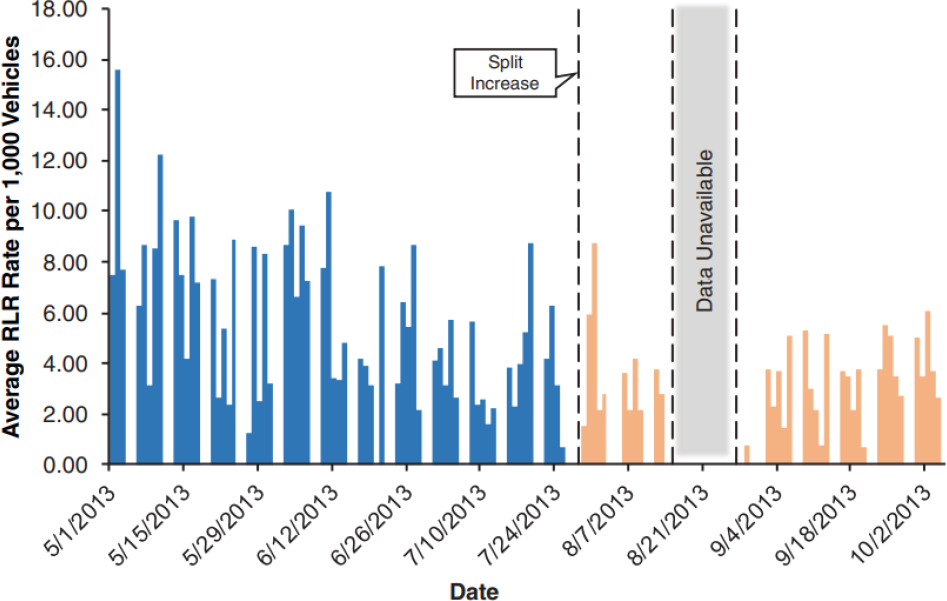
One of the most relevant studies was by Lavrenz et al. (2016), where they used high-resolution signal controller data to estimate red light running (RLR) at signalized intersections. One intersection in Indiana was analyzed in this research to explore the relationship between RLR and level of congestion using split adjustments on a side street that experiences split failures. The study utilized conventional stop bar loop detection from high-resolution signal controller logs with signal state data to identify vehicles that enter the intersection after the start of red. A vehicle was flagged as RLR when the stop bar detector recorded an “on” event and subsequent “off” event after the start of red on the phase. The methodology was validated with on-site video collection at several locations, and the algorithm was refined to reduce the incidence of false RLR indications (Lavrenz et al. (2016)). Results from the study site showed that a change in green split from 20% of cycle length to 24% on the subject side street reduced the RLR rate. This trend is shown in Figure 1.
The study also found that the increase in split duration resulted in a reduction of approximately 34% in daily RLR counts. While this study developed a methodology to estimate RLR events, with the advancements in detection technology, most agencies today can use “count” detectors that are placed just downstream of a stop bar (with a minimum speed threshold) to directly obtain RLR using the Yellow and Red Actuation ATSPM report.
Chen et al., (2017) used high-resolution signal controller logs collected from loop detectors at five intersections in Minneapolis, MN to identify the influential factors associated with RLR and estimate RLR frequency. The study found that RLR is most likely to occur on weekdays during peak periods under large traffic demands and longer signal cycles (which is expected as large traffic demands increase the likelihood of RLR occurrence compared to low traffic demands and congested periods with longer cycles increase vehicle delay, also increasing the likelihood of RLR). The study also found that vehicles following the leading vehicle with short headways during phase transition are also more likely to run the red light. While these findings provide important insights into the factors that cause RLR, they are less relevant for the context of CMF development for this research.
Kabir et al., (2021) evaluated the impact of signal performance on traffic safety along urban arterials using crash data. The study used vehicle trajectory data to create two signal performance measures (percent arrivals on green, or POG, and level of travel time reliability, or LOTTR) for 121 signalized intersections on ten corridors near Columbus, Ohio. In addition to the two performance measures, the study utilized several variables for the crash analysis including major AADT, minor AADT, speed limit, intersection skew presence, presence of dedicated left turn and right turn lanes. Three years of crash data (August 2016 to August 2019) was obtained for the analysis. Results showed that POG is negatively associated with total crash occurrence, in which one percent increase in percent arrivals on green is associated with a reduction of 1.12% in total crashes (Kabir et al., (2021)). Even though the study did not use ATSPM data, the findings from this research could be helpful for case B CMF development (i.e., for Percent Arrivals on Green CMF development)
Key Findings Related to Safety Effects of other Signal System Solutions
Most research related to the CMF development for signal system projects was found in the area of left turn phasing strategies (i.e., permitted versus protected) and adaptive traffic signal control (ATSC) deployment. For the left turn phasing strategies, while ATSPMs were not utilized in these studies, the findings can be beneficial during the development of case B CMFs for the left-turn gap analysis.
Studies Related to Left Turn Phasing Strategies
Srinivasan et al., (2012) estimated CMFs from before-and-after evaluations of two treatments targeted at reducing left-turn crashes at signalized intersections: (1) changes from permissive to protected-permissive phasing, and (2) changes from the implementation of a flashing yellow arrow (FYA) for permissive left turns. For the first evaluation (i.e., from permissive to protected-permissive), data was collected from 59 treated and 626 untreated intersections in Toronto and 12 treated and 49 untreated intersections in North Carolina (various unspecified urban areas). For the second evaluation (i.e., FYA), data was collected from 5 treated and 27 untreated intersections from Kennewick, Washington, and 30 treated and 45 untreated intersections from Oregon (Beaverton, Gresham, Oregon City, and Portland), and 16 treated and 49 untreated intersections in North Carolina. Crash data was collected for at least 3 years from these various sites. To determine intersection related crashes, crashes that occurred within 25 meters (about 82 feet) of an intersection are used in Toronto and within 72 meters (about 250 feet) in North Carolina (other sites were not specified in the study). Table 3 provides a summary of the CMFs for different treatments and under varying groupings.
| Treatment | Grouping | CMF Value by Crash Type and Severity | |||
|---|---|---|---|---|---|
| Total | Fatal and Injury | Left-Turn & Opposing Through | Rear End | ||
| From permitted left to protected-permitted left turn | 71 sites from North Carolina and Toronto | 1.031 | 0.962 | 0.862 | 1.075 |
| From protected on two legs to protected-permitted with FYA | 5 sites from North Carolina | 1.509 | 1.479 | 3.696 | 1.752 |
| From permissive on one-leg and protected-permissive on one leg to protected-permitted with FYA | 5 sites from North Carolina | 0.827 | 0.911 | 0.586 | 1.058 |
| From protected-permissive to protected-permissive with FYA | 6 sites from North Carolina | 0.954 | 0.752 | 0.700 | 1.344 |
Bold values indicate CMFs that are statistically different from 1.0 at the 5% confidence level
FYA ‒ Flashing Yellow Arrow.
Results show that changing from permissive to protected-permissive phasing statistically significant reductions on left turn opposing through crashes with a CMF of 0.862. However, when all crashes were combined or only injury and fatal crashes were considered, CMFs are very close to 1.0 and not statistically significant. Results from the FYA implementation showed that, not surprisingly, when a protected left turn phase was converted to protected-permitted with FYA, crashes increased considerably compared to before conditions. This increase is most likely due to the introduction of the permitted phase rather than the FYA
deployment. Results show that the implementation of FYA provided a benefit at intersections that had some of kind of permissive left turn operation in the before conditions (Srinivasan et al., (2012)).
Goughnour et al., (2021) focused on developing CMFs for improving pedestrian safety for protected or protected/permitted left turn phasing and LPIs. Researchers collected data from four North American cities from over 100 sites both for left turn phasing and LPIs. Data was collected from reference sites as well. Crash data was also collected from these cities with a focus on both vehicle-pedestrian and vehicle-vehicle crashes. Results showed that the provision of protected left-turn phasing reduced vehicle-vehicle injury crashes but did not produce statistically significant results for vehicle-pedestrian crashes.
Studies Related to Adaptive Traffic Signal Control (ATSC) Deployment
A recent study by Avelar et al., (2021) conducted safety effectiveness evaluations of ATSC deployments on urban corridors and developed CMFs for ATSC. Safety data was collected from Florida (87 intersections), Texas (25 intersections), and Virginia (68 intersections). For all three data sets, the research team used several variables to describe each site. These variables are grouped in the following categories:
- Traffic control device and ATSC related variables (e.g., when and where it was installed)
- Roadway design elements (e.g., number of legs, number of through lanes, lane width, number of left turn lanes, presence of bike lanes, median width, etc.)
- Traffic volume (i.e., AADT for major and minor legs), and
- Crash data (e.g., total number of crashes, crash severity)
To select intersection-related crashes, only crashes occurred within a 250-feet buffer around each intersection are selected. A total of 7 to 8 years of crash data (varied by site) were utilized for the before and after analysis. Table 4 provides a summary of the analysis results. For total crashes, CMFs ranged from 0.867 to 1.045 and only for the Virginia site, deployment of ATSC resulted in statistically significant reductions in total crashes. There were no discussions in the study related to why the produced CMF values ranged from one location to another. Additionally, most of the CMFs in the below table are not statistically significant and close to 1.000.
Table 4. Comparison of CMFs for adaptive traffic signal control (Source: Avelar et al., 2021).
| State | Methodology | CMF Value by Crash Type and Severity | ||||
|---|---|---|---|---|---|---|
| Total | Fatal and Injury | Property Damage Only | Angle | Rear End | ||
| Florida | Empirical Bayes | 1.045 | 1.039 | 1.022 | 1.207** | 1.003 |
| Florida | Full Bayesian | 1.042 | 1.033 | 1.027 | 1.239 | 0.940 |
| Texas | Generalized Linear Segmented Regression | 1.000 | 1.105 | 0.953 | 1.028 | 0.560** |
| Virginia | Generalized Linear Segmented Regression | 0.867* | 0.642** | 1.019 | 0.604** | 1.020 |
* ‒ Statistical significance at a 90-percent confidence level.
** ‒ Statistical significance at a 95-percent confidence level.
Tang et al., (2020) also researched the safety effects of ATSC deployments from Pennsylvania. Data was collected from 342 intersections with ATSC deployments. Similar to previous studies, crashes reported within 250 feet of the intersection were included. The “after” data period (after the ATCS were deployed)
ranged from 1 year to 8 years. CMFs were estimated for varying scenarios including crash severity levels and crash types, intersection locations (all intersections and intersections along corridors only), and intersection configurations (3-leg versus 4-leg intersections). The results suggested that ATSCs are associated with a marginal increase in total and angle crashes and a marginal decrease in fatal plus injury crashes and rear-end crashes. Interestingly, all statistically significant CMFs indicated an increase in crashes with ATSC deployments.
Ma et al., (2016) also explored the safety implications of ATCS by examining 47 urban and suburban intersections along 10 corridors in Virginia. Vehicle crash data was collected between 2006 and 2013 for the before-and-after comparison. The study found that installing ATSC resulted in a CMF of 0.83 for total intersection crashes that are statistically significant at a 95 percent confidence level. However, when only fatal and injury crashes were analyzed, crashes did not change by a statistically significant amount. Similar to previous studies, Ma et al., (2016) found that safety benefits varied from corridor to corridor and by volume levels. However, no model is developed, and no discussion is provided regarding the way the results of this study can be utilized for other agencies or corridors with different characteristics.
Key Findings Related to CMF Development
Most studies related to the CMF development for signalized intersection treatments used before-and-after (i.e., before the treatment and after the treatment) evaluations using crash data. For those studies, crash data was also collected from untreated intersections with similar characteristics to the treatment site (i.e., control site or reference site) for comparison. To determine intersection related crashes, researchers typically used crashes that occur within 250 feet of an intersection. To ensure statistically significant CMFs can be developed, at least three years of crash data was obtained and analyzed from several signalized intersections (sometimes over 100 intersections). In addition to crash data, most researchers (Goughnour et al., (2021)) (Tang et al., (2020)) also collected the following data types to understand the effect of intersection characteristics on safety:
- AADT and pedestrian volumes
- Number of intersection legs
- One- or two-way direction of streets
- Number of through lanes
- Number of turn lanes
- Combination of through and turn lanes
- Presence of a crosswalk
- Presence of a median
Most studies found in the literature developed CMFs for various crash types. These include developing CMFs for all crashes, injury/fatal crashes, and target crash types (e.g., left turn opposing crashes for protected and permitted left turns, rear-end crashes for arrivals on green). One main challenge that was raised by researchers in these studies was the difficulties in finding sites with the needed data. Some of the studies indicated that after requesting data and locations from agencies, additional data collection was needed as the initial sites did not meet the desired data needs to develop CMFs (e.g., limitations in completeness of the data, varying data format). To address the data limitations, researchers sometimes utilized different “study designs” by location.
Another common observation related to CMF development is the various analysis methods in the evaluation. Most researchers used Empirical Bayes and Fully Bayesian methods. Other methods utilized in the CMF development include random parameter negative binomial model and generalized linear regression. While not many studies related to CMFs for signalized intersection treatments compared these different methods, a recent study by Avelar et al., (2021) claims that the Full Bayesian method produced better CMF values than the Empirical Bayes.
One main limitation regarding the application of the CMFs produced in some of the studies is that CMFs were developed for each state and not much discussion is provided related to why the CMF values were different for each location. This makes it challenging for practitioners to use the findings as design and intersection characteristics can substantially influence the safety performance of ATSC.
Agency Outreach Summary
The agency outreach task was completed in two sub-tasks as described below:
- A survey was distributed to identify agencies and practitioners who regularly utilize ATSPMs for signal systems and gather some general information about these systems.
- In addition to the survey, the research team reached out directly to targeted agencies and practitioners that are known to use ATSPMs to conduct phone interviews. The objective of these interviews was to obtain information about specific ATSPM systems and the availability of related archival data and potential sites for Phase II of the research.
Agency Survey
The team developed a draft survey for distribution to the agencies to better understand the way agencies use ATSPMs to make signal timing adjustments, especially for safety-based decision making, and whether agencies would be interested in sharing data with us for this project. Additionally, the survey aimed at identifying potential intersections and corridors for use for those agencies that utilize ATSPMs. Based on the Panel comments, the survey is refined and finalized.
The finalized version of the survey was distributed during the monthly ATSPM meeting that is led by the Federal Highway Administration (FHWA). Additionally, the survey was distributed to the members of the AASHTO Committee on Traffic Engineering (CTE) and to the members and friends of the TRB’s Traffic Signal Systems Committee. Finally, the survey was also posted on the ITE’s e-Community.
Following the outreach activities, the research team received 13 responses to the survey. Out of the 13 responses, 11 represent public agencies, one consulting firm, and one data collection vendor. Nine of the respondents indicated that they use ATSPMs. Table 5 summarizes agency type along with their characteristics and the use of ATSPMs for those agencies that utilize ATSPMs.
The highest number of ATSPM-equipped signals are operated by Georgia DOT, followed by Utah DOT, and Minnesota DOT. For cities and counties, agencies operate 100 or fewer ATSPM-equipped signals. Interestingly, when it comes to the type of ATSPM interface used, four agencies use other ATSPM platforms in addition to the Open Source (UDOT) ATSPM software. In terms of the typical detection scheme for ATSPM-equipped signals, each agency provided a different combination of detectors used.
Out of the 11 agencies that operate ATSPM-equipped intersections, 7 agencies reported that they used ATSPM reports explicitly for safety-based decision-making. Each response consists of multiple responses. The frequency of each ATSPM report used for safety-based decision-making is shown in Figure 2.
Table 5. Summary of ATSPM deploying agencies who responded to the survey.
| # | Agency | Agency type | # of signals under the jurisdiction | # of ATSPM-equipped signals | Type of ATSPM interface |
|---|---|---|---|---|---|
| 1 | Macomb County Department of Roads | County | 740 | 40 | Open Source (UDOT) ATSPM Software Iteris Signal Performance Measures (SPM) |
| 2 | Bernalillo County | Country | 63 | 45 | Econolite Centracs SPM |
| 3 | Louisville-Jefferson County Metro Government | Country | 1,012 | 100 | Open Source (UDOT) ATSPM Software |
| 4 | Georgia DOT | State | 6,500 | 4,000 | Open Source (UDOT) ATSPM Software Intelight MAXVIEW |
| 5 | Missouri DOT | State | 2,100 | Several (not specified) | Parsons iNET TransCore/TransSuite Open Source (UDOT) ATSPM Software |
| 6 | City of Albuquerque | City | 655 | 100 | Open Source (UDOT) ATSPM Software |
| 7 | Oklahoma DOT | State | 4 | 4 | Econolite Centracs SPM |
| 8 | Utah DOT | State | 1,373 | 2281* | Open Source (UDOT) ATSPM Software |
| 9 | Minnesota DOT | State | 1,600 | 1,000 | Intelight MAXVIEW Open Source (UDOT) ATSPM Software QFREE Kinetics |
* ‒ UDOT owns 1,373 signals; however, they also have 52 other cities that share the same communications and ATSPM, leading to a total of 2281 signals.
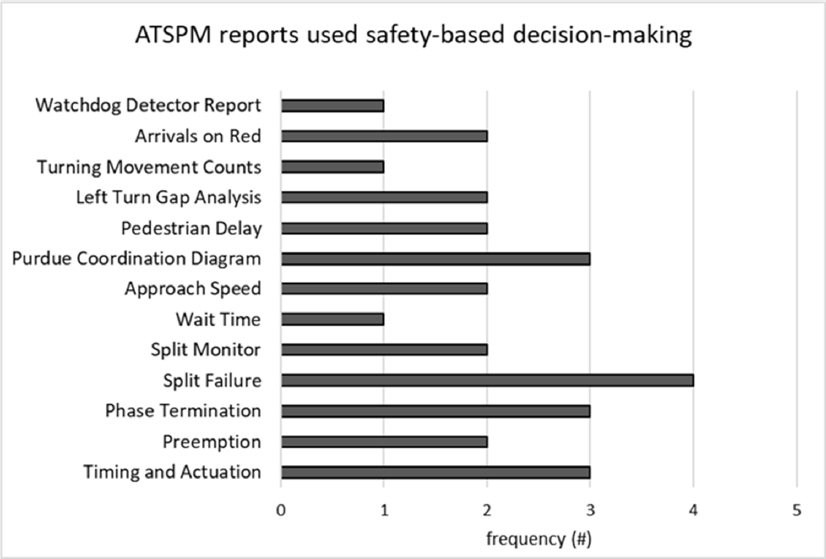
The trends shown in Figure 2 indicate that the Split Failure, Phase Termination, Timing and Actuation, and Purdue Coordination Diagram are the most common ATSPM reports used during safety-based decision making. However, it may be misleading to extrapolate these observations to other agencies due to the limited number of responses to the survey.
Targeted Agency Outreach and Phone Interviews
In addition to the survey, the research team conducted targeted outreach and phone interviews. Table 6 shows the list and provides a summary of key findings related to the potential corridors and intersections that can be used in Phase II.
Table 6. Selected individuals for targeted outreach and a summary of key findings.
| Agency/Vendor | Interview Summary |
|---|---|
| Colorado Springs, CO | Indicated that it is unlikely for their data to be useful for this research. |
| Florida DOT | Indicated that they may have corridors/intersections for case A and case B CMFs. The research team is still in coordination with FDOT. |
| Georgia DOT | Provided two corridors for case A CMFs and three intersections for case B CMFs. |
| Indiana DOT | Indicated that it is unlikely for their data to be useful for this research as they don’t have a systematic deployment of ATSPMs. |
| Maricopa County, AZ | Provided three corridors for case A CMFs, indicated that they can provide several intersections for case B CMFs. |
| Oregon DOT | Indicated that there are no potential corridors or intersections for the research. |
| Pennsylvania DOF | Provided two intersections for case B development. |
| Phoenix, AZ | Indicated that it is unlikely for case A CMFs, but can provide data for potential case B intersections |
| Portland Bureau Of Transportation | Indicated that it is unlikely for their data to be useful for this research. |
| Sebago Technics | Indicated that one potential corridor could be utilized for case A CMFs and a second intersection for case B CMFs |
| Utah DOT | Provided access to LogBook, crash database, and consultant reports to identify potential sites. Several corridors and intersections were identified by the research team both for the case A and case B CMFs. |
| Virginia DOT | Provided three corridors for case A CMFs and several intersections for case B CMFs. |
| Miovision | Indicated that it is unlikely for their clients’ data to be useful for this research. |


