Community-Driven Relocation: Recommendations for the U.S. Gulf Coast Region and Beyond (2024)
Chapter: 2 The Scale of the Threat
2
The Scale of the Threat
This chapter discusses the following:
- The physical environment of the U.S. Gulf Coast Region and environmental hazards, including climate changes (e.g., rising temperatures, changing precipitation), and human-induced hazards (e.g., petrochemical spills and ongoing fossil fuel extractions)
- Disruptive infrastructure and the industrial impacts on regional flood risk
- Displacement projections and population growth
THE GULF COAST PHYSICAL ENVIRONMENT AND THE SCALE OF CLIMATE CHANGE
Introduction
Changes in temperature, precipitation, and the associated sea level rise (SLR) threaten Gulf Coast communities. Compounding these hazards are existing environmental toxins and socioeconomic stressors from the very industries that sustain the region, creating tensions that threaten households and livelihoods. Yet even as risks increase, the scale of the threat of displacement is poorly understood by decision makers and communities, and the disproportionate impact on the most vulnerable communities has yet
to be comprehended in ways other than quantitatively. Moreover, instead of populations withdrawing from environmentally high-risk areas, many places in the Gulf region are increasing in population as individuals, businesses, and government continue to invest in high-risk areas, where the frequency and scale of climate-related disasters are on the rise.
The Gulf of Mexico (as seen in Figure 2-1), one of the largest bodies of water in the world (Mendelssohn et al., 2017), with a watershed consisting “of 33 rivers draining from 31 U.S. states” and much of Mexico (EPA, 2022), is a vast, complex ecosystem of fresh and saltwater marshes, coral reefs, seagrasses, mangrove forests, marine algae, and marsh grasses. The Gulf is connected to the Caribbean Sea through the Yucatán Channel where sea water circulates clockwise, then exits into the Atlantic Ocean through the Florida Straits. About half of the U.S. Gulf Coast Region—spanning the states of Florida, Alabama, Mississippi, Louisiana, and Texas, and continuing south to Mexico—consists of shallow waters of the continental shelf, which has yielded evidence of human presence through anthropogenic shell deposits (i.e., middens) from over 10,000 years ago (Cook Hale et al., 2019).
The physical geography of most of the Gulf Coast is dominated by barrier islands fronting lagoons and low-lying marshy shores. Whereas in southwest Florida, mangrove forests dominate, salt marshes characterize the Big Bend and Apalachee Bay areas of Florida, and the Mississippi River enters the Gulf through a bird’s foot delta (Coultas & Gross, 1975; Lagomasino et al., 2021; Ward et al., 2023).
Over time, these numerous streams and rivers, which drain a humid region, have carved the landscape of the region as they course toward the Gulf. The U.S. Gulf Coast has modest tidal ranges and is a fairly low energy area except when tropical cyclones occur. There are numerous bays, such as Tampa, Pensacola, Mobile, Galveston, and Corpus Christi, where larger rivers enter the Gulf. The bays have typically been the site for urban and commercial development.
Environmental Hazards
The coastal area of the U.S. Gulf Coast Region faces multiple co-occurring, and intensifying, environmental hazards, including climate changes (e.g., rising temperatures, changing precipitation, more intense storms, rising sea level), which in turn can lead to pluvial (surface water) flooding, fluvial (riverine) flooding, modest tidal flooding, greater reach on storm surge, and compound flooding (Sebastian, 2022). Coupled with these climate events, human-induced hazards (e.g., petrochemical spills and ongoing fossil fuel extractions) amplify risks to the area (Kühne & Koegst, 2023) and escalate land subsidence. The committee defines land subsidence as the
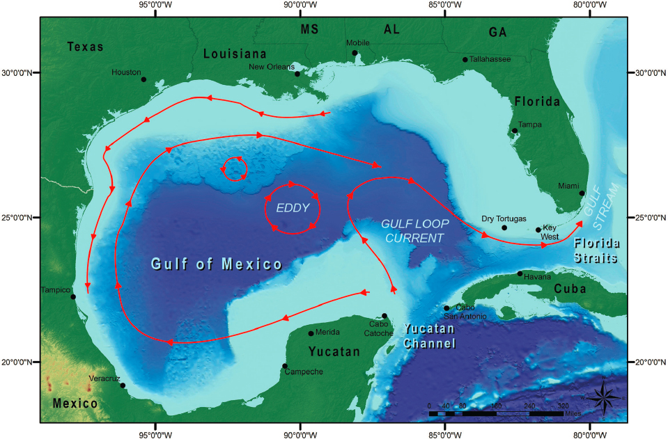
SOURCE: Flower Garden Banks National Marine Sanctuary. (2023). Basic current patterns in the Gulf of Mexico, including the Loop Current. Office of National Marine Sanctuaries, National Oceanic and Atmospheric Administration. https://flowergarden.noaa.gov/about/naturalsetting.html
sinking of land due to compression of sediments, removal of groundwater or other subsurface fluids, or geologic processes such as faulting or isostatic adjustment (a section on subsidence is further below).
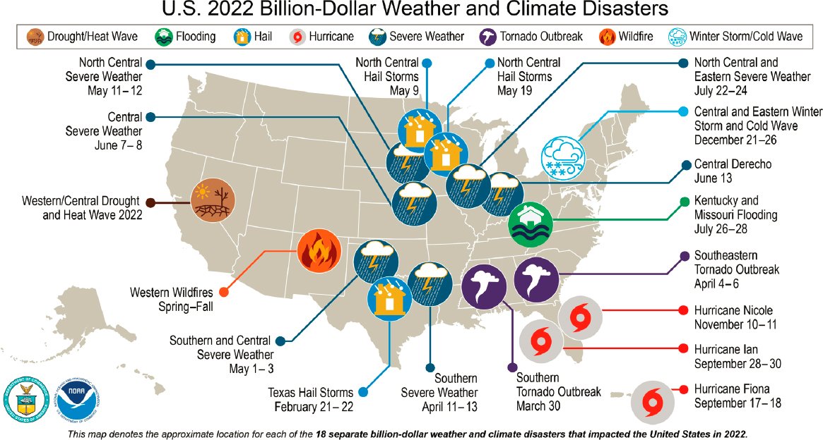
Although these hazards are experienced across the United States in both inland and coastal regions, research shows that the most rapid SLR in the United States can be found in the Gulf Coast (National Academies of Sciences, Engineering, and Medicine, 2018b; Lane et al., 2018). Research has also found that, based on the anticipated effect of projected tropical cyclone climatology change, projected increases in 100-year flood levels are expected to be greater than the effect of SLR for more than 40 percent of Gulf Coast counties (Marsooli et al., 2019). When storm surges are incorporated into these models’ estimation of coastal risks of climate change, increased impacts are seen in the Gulf Coast (Neumann et al., 2015). To better understand the scale of the threat, the National Oceanic and Atmospheric Administration’s (NOAA’s) 2021 summary of billion-dollar weather and climate disasters shows an alarming cluster in the U.S. Gulf Coast Region (see Figure 2-2 below); the year 2022 tied 2017 and 2011 for the third highest number of billion-dollar disasters nationally.
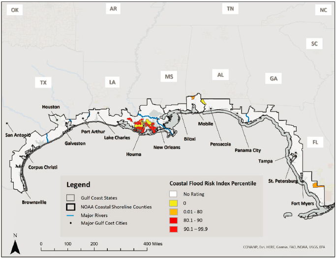
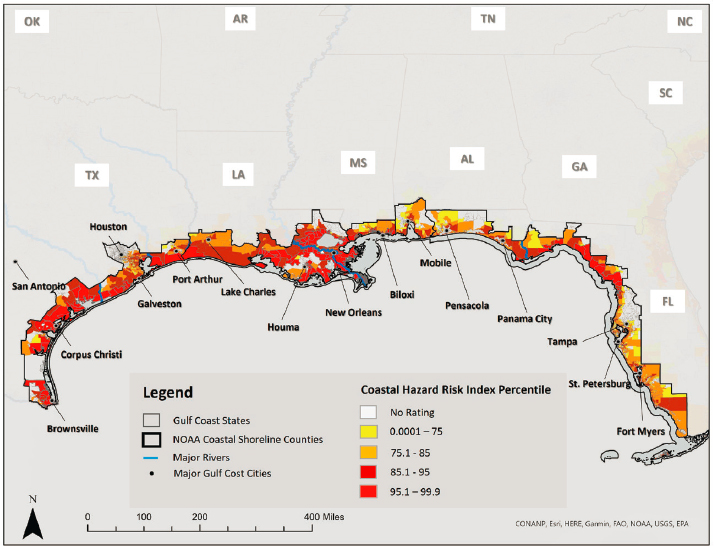
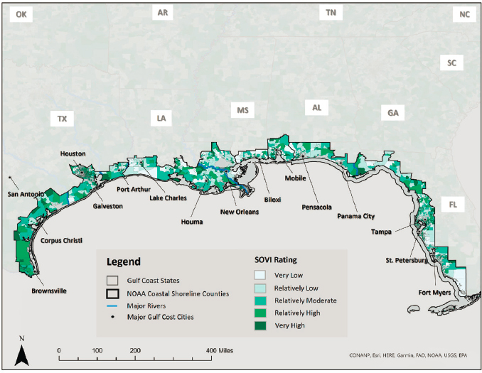
Across the U.S. Gulf Coast Region, climate change,1 combined with natural processes that shift landforms and the impacts of polluting and extractive industries, compounds regional risks and associated vulnerabilities. According to the Federal Emergency Management Agency’s (FEMA’s) National Risk Index (NRI), many Gulf communities have moderate to very high-risk indices, with respectively high economic risks associated (Zuzak et al., 2022). In areas where social vulnerabilities are also high and community resilience is low, according to the NRI, the compounded effect of climate change and other natural hazards challenges community readiness to prepare for, and respond to, events as they occur. Hurricane and coastal flood risks combined with social vulnerabilities estimate high or very high risks in the region. Figures 2-3, 2-4, and 2-5 show these risks, which cascade to worsen public health outcomes and overall well-being (Watts et al., 2018), emphasizing the scale of the threat to the Gulf Coast.
Climate Change and Its Impacts
Projected changes in extreme heat (including more days with higher temperatures), greater storm intensity, inland flooding (pluvial or fluvial), SLR (and associated tidal flooding and storm surge), and groundwater compound and amplify risks in the Gulf Coast.
___________________
1The science of climate attribution is now able to quantify not only the degree to which human-caused climate change is contributing to SLR, but also the impact of heat-trapping emissions on changes in the frequency and severity of extreme heat, drought, and precipitation (National Academies, 2016). See also Union of Concerned Scientists (2017).
SOURCE: Smith, A. (2023). 2022 U.S. billion-dollar weather and climate disasters in historical context. National Centers for Environmental Information, National Oceanic and Atmospheric Administration. https://www.climate.gov/news-features/blogs/2022-us-billion-dollar-weather-and-climate-disasters-historical-context
NOTES: FEMA obtains tribal community data from two sources: (1) “the Homeland Infrastructure Foundation-Level Data American Indian/Alaska Native/Native Hawaiian Areas shapefile that is adapted from the U.S. Census Bureau’s TIGER/Line American Indian Area Geography shapefile. The shapefile includes federally recognized American Indian reservations and off-reservation trust land areas, state-recognized American Indian reservations, and Hawaiian homelands;” and (2) “the FEMA Mitigation Planning Jurisdiction Layer,” which is “adapted from the Bureau of Indian Affairs geographic information system […] data. This data includes Land Area Representations […] and Tribal Statistical Area, among other types of tribal areas […] Census tracts that intersect a tribal area, but with less than 5% coverage in a Census block, were visually inspected to ensure that areas of intersection arose out of natural imprecision in the boundaries rather than valid cases of small tribal areas within the Census tract” (Zuzak et al., 2023, pp. 4-9–4-10).
SOURCE: Committee generated from data at https://hazards.fema.gov/nri/data-resources
Extreme Heat
Rising temperatures introduce three types of changes in how people experience heat: (1) an increase in the average temperature, (2) an increase in the number of extreme heat days, and (3) an increase in the frequency and duration of heat waves and longer heat seasons. While increases in average temperatures allow time for behavioral and environmental changes to accommodate those increases, extreme heat days and/or the frequency and duration of heat waves present much greater challenges. For example,
SOURCE: Committee generated from data at https://hazards.fema.gov/nri/data-resources
in the U.S. Gulf Coast Region by the end of the century, many communities will experience 5–10 times more extreme heat days than 100 years prior, as shown in Table 2-1 (U.S. Federal Government, 2023).
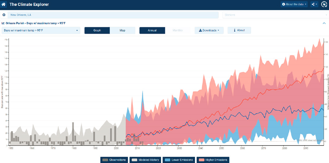
This predicted trend is illustrated in the Climate Explorer’s image of extreme heat days in Orleans Parish, Louisiana (see Figure 2-6). It charts the number of previous extreme heat days experienced from 1961 to 1990, alongside potential scenarios with lower and higher emissions.2 From 1961 through 1990, Orleans Parish had an average of seven days over 95F. Looking forward to the middle of the 21st century, that number is expected to increase to over 46 in both the lower and higher emissions scenarios. Toward the end of the 21st century, as the emission models diverge, that number could be between 57 and 116 days per year.
Extreme heat is a serious threat on multiple levels. On average, extreme heat kills more people annually than any other weather-related hazard
___________________
2More information about the Climate Explorer is available at https://crt-climate-explorer.nemac.org/. The Climate Explorer uses the Representative Concentration Pathway (RCP) 4.5 to represent lower emissions and RCP 8.5 for higher emissions (van Vuuren et al., 2011).
SOURCE: Committee generated from data at https://hazards.fema.gov/nri/data-resources
TABLE 2-1 Days Over 95F (Historic and Projected) Across the Gulf Coast
| Location | 1961–1990 Days/Year Over 95F | 2050–2090 Projected Days/Year Over 95Fa |
|---|---|---|
| Houston, Texas | 20 | 81–130 |
| New Orleans, Louisiana | 7 | 57–116 |
| Gulfport, Mississippi | 8 | 52–108 |
| Mobile, Alabama | 9 | 57–114 |
| St. Petersburg, Florida | <1 | 60–127 |
a Under a higher emissions scenario representing Representative Concentration Pathway 8.5.
SOURCE: NOAA. (2023). U.S. Climate Resilience Toolkit Climate Explorer. https://crt-climateexplorer.nemac.org/faq/
SOURCE: NOAA. (2023). U.S. Climate Resilience Toolkit Climate Explorer. https://crt-climate-explorer.nemac.org/faq/
(National Weather Service, 2022). Beyond its risk to human health, particularly for those with chronic health conditions, extreme heat reduces worker productivity in unconditioned (outdoor workers) or under-conditioned spaces (factories); it also damages crops and fisheries and reduces yields (Kinniburgh et al., 2015; Parker, McElrone et al., 2020).
Extreme heat in the Gulf will continue to increase and in turn increase risks to health, demands for energy via increased cooling loads, and energy cost burdens for households. For the purposes of this study, however, extreme heat is not considered the primary risk but a precursor to the chronic flooding that is driven from increases in storm intensities, rising sea levels, and compounding issues of subsidence that have the greater immediate impact on the ability of Gulf Coast residents and businesses to sustain their existing ways of life.
Precipitation and Storm Intensity
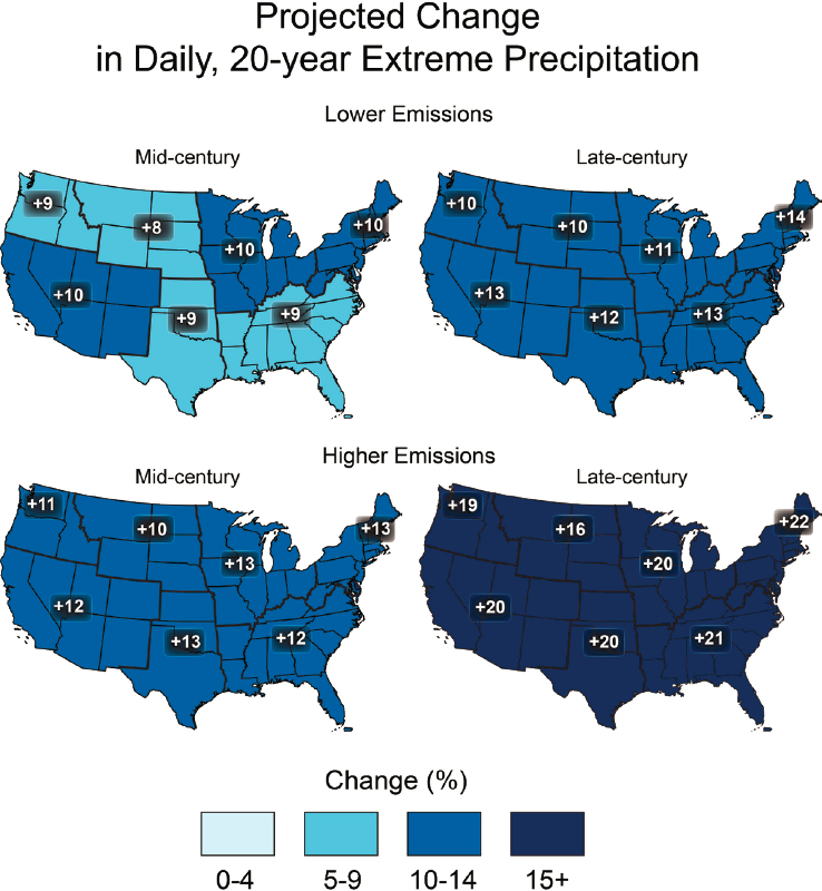
Although net precipitation across the Gulf Coast is not projected to significantly change with either higher or lower emissions, warmer air holds more moisture and can produce more intense storm events. Increases of up to 20 percent in amounts of extreme precipitation are expected under a higher-heat scenario by the end of the century (Easterling et al., 2017; see Figure 2-7 below). Intensifying rainfall, also known as cloudburst events, contributes to inland flooding and exacerbates riparian risk (Statkewicz et al., 2021; EPA, n.d.). Moreover, such storms increase health risks in terms of both direct impacts from drowning or electrocution, for example, and indirect impacts from power loss, increased mold, or increases in vector- and water-borne diseases (Du et al., 2010).
Tropical Cyclones
A recent study simulating hurricanes in the Gulf region found that while there may be somewhat fewer hurricanes, storm intensities are expected to increase in speed of movement inland and intensification near shore, with more category 3, 4, and 5 hurricanes alongside 30–40 percent increases in precipitation (Bruyère et al., 2017). The simulations project an increase of approximately 10 percent in damage for the most intense hurricanes; this would seem manageable until compared to Hurricane Katrina losses, which were estimated based on the adjusted 2023 Consumer Price Index at approximately 194 billion dollars, and Hurricane Harvey losses estimated at 155 billion dollars (NOAA National Centers for Environmental Information, 2023).
The contribution of tropical cyclone climatology change to the 100-year flood level is highest in Gulf Coast parishes and counties, suggesting
SOURCE: Easterling, D. R., Arnold, J., Knutson, T., Kunkel, K., LeGrande, A., Leung, L. R., Vose, R., Waliser, D., & Wehner, M. (2017). Precipitation change in the United States. Climate Science Special Report: Fourth National Climate Assessment, Volume I (pp. 207–230). U.S. Global Change Research Program. https://doi.org/10.7930/J0H993CC
a potential increase in the “frequency, intensity, and/or size of [tropical cyclones] by the end of the 21st century” (Marsooli et al., 2019, p. 5). These findings are especially important given that current FEMA maps for flood risk do not account for the expected impacts of climate change on SLR and the intensity and frequency of tropical cyclones (Marsooli et al., 2019). Bates et al. (2021) estimated that the 100-year flood area (1% annual ex-ceedance, which incorporates fluvial and pluvial flooding) is approximately double that estimated by FEMA maps (1,007,000 km2 vs 572,000 km2). The ability to predict weather events has improved in recent decades; however, rapid intensification of tropical cyclones approaching the coast has reduced forecast reliability and the time for effective evacuation planning (Benedetto & Trepanier, 2020).
Pluvial Flooding
Increased storm intensities introduce extreme rainfall, or cloudburst events, which means more rain falling in shorter time periods. In the U.S. Gulf Coast Region, Easterling et al. (2017) illustrate increases in such events of 9–13 percent between mid- and end of century with a lower emissions scenario and of 12–21 percent with a higher emissions scenario. In 2021, this type of rainfall event introduced significant pluvial flooding in Lake Charles, Louisiana, with a total of 12.49 inches of rain in a 24-hour period, where more than 6 inches fell in two hours (Di Liberto, 2021). Similarly, 26 inches of rain fell during Hurricane Harvey over a 24-hour period over Beaumont and Port Arthur, Texas (Di Liberto, 2021). According to a study of U.S. insurance claims, pluvial flooding is more common than fluvial, and pluvial flood insurance claims are more likely during tropical cyclone floods than non-tropical cyclone floods. This type of flooding often occurs because the volume of water far exceeds the capacities of traditional stormwater management systems (Tonn & Czajkowski, 2022).
Fluvial Flooding
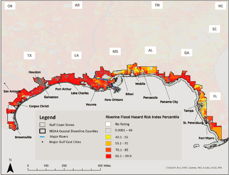
FEMA’s NRI illustrates the projected extensiveness of fluvial flooding in Gulf coastal counties. Also, a recent study identified previously unrecognized channels as contributors to Gulf region fluvial flood risks (Swartz et al., 2022). Figure 2-8 shows these fluvial flooding risks. Moreover, Marsooli et al.’s (2019) study of the impacts of SLR and tropical cyclone climatology change on flood hazards from the Gulf Coast and U.S. Atlantic Coast at the county level found that from 1980 to 2005, Gulf Coast counties not only had the highest 100-year flood levels, averaging 3.03m, but also saw the largest increase in 100-year flood levels, with an average increase of 2m. These historical 100-year flood levels are projected to occur every 5–30 years across Gulf Coast counties (Marsooli et al., 2019).
SOURCE: Committee generated from data at https://hazards.fema.gov/nri/data-resources
Sea Level Rise
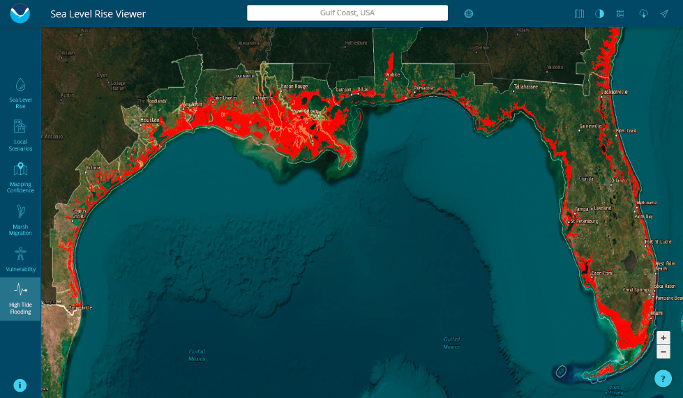
NOAA’s 2022 Sea Level Rise Technical Report describes sea levels rising on average by 10–12 inches along U.S. coasts in the next 30 years, increasing tidal and storm surges, which in turn will reach farther inland (Sweet et al., 2022). In the Gulf Coast, this number is greater, with 14–18 inches projected. Relative sea level (land and ocean height change) is expected to be highest in the Gulf Coast due to subsidence as well as other factors such as “river sediment compaction and withdrawal of subsurface fluids” (Sweet et al., 2022, p. XII). In turn high tide flood events will “continue to occur at or above the national average frequency” (Sweet et al., 2022, p. XIII). For the Gulf Coast, this will yield an increase in the number of flood events (see Figure 2-9; Sweet et al., 2022). More frequent high tide events are also projected across the Gulf (see Figures 2-9 and 2-10). Projections suggest that by 2050, the western Gulf will see the highest number of flood events in the larger region (Sweet et al., 2022). Given that SLR escalation

SOURCE: Office for Coastal Management. (2023c). Sea Level Rise and Costal Flooding at 1’: Gulf of Mexico. https://coast.noaa.gov/slr/

SOURCE: Office for Coastal Management. (2023b). Coastal Flood Exposure Mapper: Gulf of Mexico. https://coast.noaa.gov/floodexposure/#-9725012,3188145,7z/eyJiIjoiZGFyayJ9
is significantly different in the Gulf and Southeast coasts (McLaughlin et al., 2018; Yin, 2023) and appears to be accelerating beyond model assumptions (Dangendorf et al., 2023), the implications for Gulf-wide population displacement warrants far more extensive review.3
Higher sea levels pose the risk of additional shoreline erosion; saltwater intrusion into freshwater environments and their disruption, rendering obsolete structural coastal protections; saltwater intrusion into groundwater supplies; increased flooding (storm surge and blue sky); and damage to transportation and energy infrastructure (EPA, n.d.).
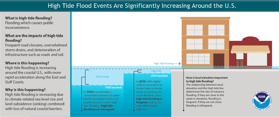
Tidal Flooding
The number of days with minor (otherwise known as nuisance) flooding in the Gulf Coast (according to eight NOAA tide gauges) has been increasing over recent decades (Sweet et al., 2014). By 2050, major and moderate high tide flood events in the Gulf are expected to occur as frequently as moderate and minor high tide flood events occur today (Sweet et al., 2022). Minor high tide flooding in the Gulf is expected to more than triple from 2020 to 2050, from 3 events per year to greater than 10, and moderate and major high tide flooding will increase from 0.3 events per year to 4 and 0.04 events per year to 0.2 in 2050, respectively (Sweet et al., 2022). Projected increases in tidal flooding are important because they are expected to cause chronic flooding in the next 15–30 years, long before communities are “permanently inundated” by SLR (Dahl et al., 2017; Office for Coastal Management, 2023b,c; Thompson et al., 2021; see Figures 2-11 and 2-12 for more information).
Storm Surge
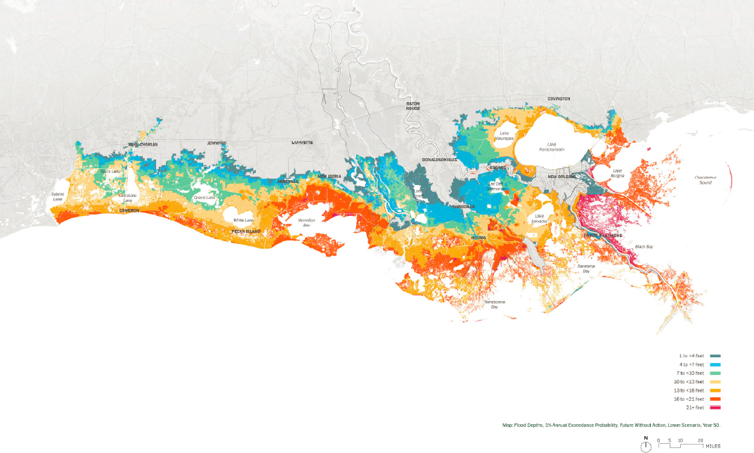
To illustrate the implications, according to the Coastal Protection and Restoration Authority (CPRA) of Louisiana, storm surge flooding will increase (due to a combination of greater storm intensities, higher sea levels, and subsidence). Figure 2-13 shows the 100 year or 1 percent Annual Exceedance Probability in Louisiana, meaning that every year there’s a 1 percent chance of this type of flooding to occur. While this example focuses on Louisiana, there are data on surge trends with SLR, erosion, and marsh health changes across the Gulf, including Bilskie et al. (2018) regarding the northern Gulf; Sheng et al. (2022) for south Florida; and Kyne (2023) for the Rio Grande Valley in Texas. Notable in the consistency of storm surge
___________________
3A map and data viewer about the economic impacts of sea level for the northern Gulf of Mexico (Florida, Alabama, and Mississippi) are available at https://experience.arcgis.com/experience/0aa2ee3b86304fffb6b97f6dd6ffa42b
SOURCE: Office for Coastal Management. (2023c). Sea Level Rise and Coastal Flooding at 12”: Gulf of Mexico. https://coast.noaa.gov/slr/
impacts, these trends substantiate Gulf-wide displacement risks (Neuman et al., 2015; Del Angel, 2022).
Despite ambitious coastal restoration efforts through CPRA, Törnqvist et al. (2020, 2021) report that the Mississippi River Delta has reached a tipping point in terms of the rate of SLR surpassing the delta’s ability to survive.4 Loss of the coastal marshes will subject interior cities, infrastructure, and land uses to increased flood risk.
Groundwater
Arguably understudied, but alarming, are changes to groundwater in the Gulf Coast states. Rising sea levels alongside subsidence contribute to rising groundwater in the Gulf in two ways. First, as seas rise, salt water and groundwater (i.e., fresh water) meet along the coast; sea water is denser than groundwater and so pushes groundwater upward. Second, groundwater typically flows toward the sea as part of the natural discharge cycle. As sea levels rise and push back against groundwater, the fresh water has less ability to flow outward to the sea and instead remains inland and rises further.
Higher groundwater poses health risks beyond flooding, as it may bring contaminants (e.g., sewage, buried toxins) to the surface as it moves upward (Pierre-Louis, 2021). In an ongoing monitoring study, groundwater contaminants are notable in 30–32 percent of the Gulf Coast aquifers (Water Resources Mission Area, 2021). Higher groundwater means that there is less area to absorb increased precipitation during extreme rain events. The Coastal Lowlands aquifer system, which serves the Gulf Coast states of Texas, Louisiana, and Mississippi, already had 12 percent of study areas with high exceedances and 18 percent with moderate exceedances of inorganic contaminants; the Florida aquifer system had 14 percent high and 18 percent moderate, respectively (Water Resources Mission Area, 2021). These issues are pertinent to relocation projects in the region as groundwater and overall aquifer health relate directly to the availability of freshwater resources in the region and to the potential impacts of more extreme storms and SLR on regional flooding.
Compound Flooding
More frequent heavy precipitation events, irregular storm surges, and rising sea levels—all impacts of climate change—also contribute to an extension of coastal influences further inland along river courses. Numerous
___________________
4More information about CPRA’s coastal restoration projects is available at https://coastal.la.gov/
SOURCE: Coastal Protection and Restoration Authority of Louisiana. (2023b). Louisiana’s Comprehensive Master Plan for a Sustainable Coast. https://coastal.la.gov/our-plan/2023-coastal-master-plan/
small river basins drain the Gulf coastal plain and, in the case of extreme rain events, these river basins are prone to flooding. Communities along these waterways tend to have flood mitigation policies and practices that are oriented toward disaster risk reduction, which are often not adequate in the face of the larger threats posed by rising seas induced by accelerated climate change, and many have yet to incorporate robust and longer-term climate adaptation strategies into local and state plans (e.g., formal plans for hazard mitigation and resilience; Cowles, 2021). Furthermore, many of the federal programs that exist to help communities facing these threats provide funding only after a disaster has occurred, thereby limiting the resources available to communities during non-disaster timeframes to conduct adaptation planning (see Chapters 9 and 10).
Compound flood risks, posed by more intense rainfall events and rising seas, strain flood mitigation measures that are not oriented to coastal influences and also pose risks to residents who have moved inland to escape coastal risks. For example, families who relocated from coastal Louisiana after Hurricane Katrina in 2005 to what they thought were safe homes found themselves exposed to riverine flooding in 2016 (Colten, 2021; Cowles, 2021). Therefore, it is imperative that planning to address these risks includes inland areas that may nominally be considered receiving communities, yet that also have inherent risks of their own. The Louisiana Watershed Initiative has quantitative data that showcase how different flooding looks when only single hazards are modeled.5
The Causes and Impacts of Subsidence
Natural processes, such as shifting sediment patterns and subsidence, exacerbate the impacts of climate change and are in turn exacerbated by the impacts of industries that continue to extract fossil fuels and water in the region. Subsidence results from several interrelated factors, including anthropogenic causes (Lane et al., 2018; United States Geological Survey Texas Water Science Center Gulf Coast Program, n.d.). Coastal erosion, water, oil and gas extraction, canal making, and faulting contribute to subsidence and overall land loss of the Louisiana coast (Lane et al., 2018).
Recent research across the Gulf shows variable ranges of subsidence, with a number of Gulf states registering +4mm/year (see Figure 2-14; Wang, Zhou et al., 2020; Zhou et al., 2021), including areas that are densely populated (see Figure 2-16 for more on area population change).
___________________
5More information is available at https://watershed.la.gov/
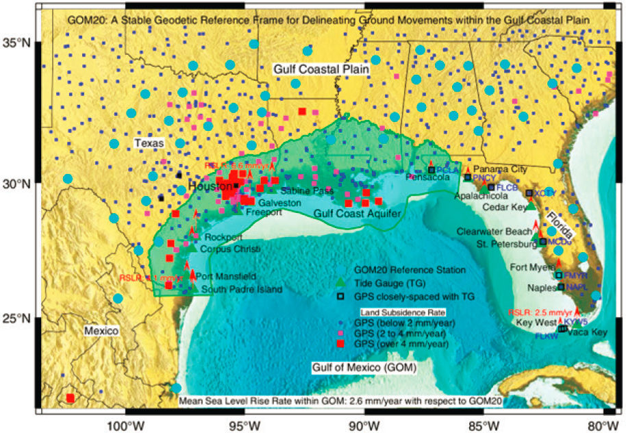
SOURCE: Wang, G., Zhou, X., Wang, K., Ke, X., Zhang, Y., Zhao, R., & Bao, Y. (2020). GOM20: A stable geodetic reference frame for subsidence, faulting, and sea-level rise studies along the coast of the Gulf of Mexico. Remote Sensing, 12(3), 350. https://www.mdpi.com/2072-4292/12/3/350
Industrial Impacts on Regional Flood Risks
Decades of infrastructure investments that have shifted natural ecologies, introduced toxic chemical and oil spills, and amplified nutrient discharges further complicate the Gulf’s flood risks.
Disruptive Infrastructure
The Mississippi River Delta is particularly at risk from storm-induced flooding and SLR. The construction of levees to protect settlements from riparian flooding since the 1700s has reduced annual sediment deposition on the floodplain and on the delta (Louisiana Coastal Wetlands Planning Protection and Restoration Act, n.d). As discussed, natural subsidence without regular rejuvenation contributes to the lowering of land surfaces. Mineral extraction and faulting also play a role. Additionally, carving canals in the coastal marshes permitted salt-water intrusion and accelerated erosion of the wetlands. All these processes contribute to land loss in the Delta region. There are active deltas, however, fed by the Atchafalaya River west of the Mississippi River’s mouth (Lane et al., 2018).
Historical investments in the region have disrupted delta ecologies and amplified climate changes and natural systems shifts: the addition of the levee systems on the Mississippi River; construction of the I-10 corridor through cities, coastal lakes and rivers, swamps, wetlands, and marshes (Florida, Alabama, Mississippi, Louisiana, Texas); dredging and channeling water basins (e.g., Mobile, Alabama; Houston and Port Arthur, Texas; Lake Charles, Louisiana) and ports for shipping, shipbuilding (e.g., Pascagoula, Mississippi), and military installations and civilian airports (e.g., Mobile, Alabama; Biloxi and Gulfport, Mississippi; Chalemtte, Louisiana); and intensive development of shorelines and barrier islands, where the natural island profile has been disrupted by large-scale development on the dune berm and the back bay area, in addition to the groins installed to trap sand (Kobell, 2015). For example, over 10,000 miles of canals carved into the Louisiana coastal marshlands permit salt-water intrusion and the destruction of freshwater marsh plants, and significantly contribute to the erosion of the wetlands (Turner & McClenachan, 2018).
Toxic Chemicals and Flood Risks
The U.S. Gulf Coast faces numerous social and environmental impacts of toxic chemical pollution (Environmental Defense Fund, 2021). The Gulf Coast is especially vulnerable due to the abundance of petrochemical and oil and gas facilities on and offshore (Minovi, 2021). Approximately 97 percent of U.S. offshore oil and gas production occurs off the Gulf Coast (Bureau of Ocean Energy Management, 2023), and Port Arthur on the
Texas Gulf Coast is home to the largest petrochemical industrial complex in the country (U.S. Energy Information Administration, 2023). Like the people and wildlife who call the Gulf Coast their home, many of these facilities are located in flood-prone areas. As of 2018, 1,400 sites that handle toxic chemicals (including polychlorinated biphenyls, heavy metals like lead and mercury, and dioxin; Sharp, 2022) were in areas deemed by FEMA as having the highest flood risk, and another 1,100 more were in areas of moderate risk (Tabuchi et al., 2018). Another report identified 872 chemical facilities that are “susceptible to experiencing a hazardous substance leak triggered by climate change within 50 miles of the U.S. Gulf Coast,” and showed that over 4 million people live within close proximity of these sites (Sharp, 2022). The risks to these chemical facilities grow as increasingly intense and frequent hurricanes and flooding occur. In the committee’s judgment, it is worth mentioning that these assessments only consider single flood risks and not compound flood risks, so it is likely an underestimation of what is exposed.
Oil Spills
Oil spills resulting from the failure of safety systems on offshore mineral extraction have been a periodic but chronic concern since the 1930s. Spills damage ecosystems, which in turn affect Gulf fisheries; they also disrupt tourism. Early near-shore oil spills have damaged oyster populations, forcing the closure of certain beds and disrupting local livelihoods (Grismore, 2018). Larger spills since the 1970s have been disruptive to both oyster and shrimping activity, sometimes impacting harvesting activities for several years (Colten et al., 2012). According to a report by the Center for Biological Diversity, between 2010 and 2020, oil companies dumped over 66 million gallons of fracking fluid into the Gulf, the effects of which include reproductive and behavioral harm and death to aquatic species (Center for Biological Diversity, 2021). Oil spills have also been shown to reduce microbial diversity and increase degradative species in wetlands (Center for Biological Diversity, 2021). In terms of recreation and tourism, a spill near Texas in 1984 disrupted recreational activity in Galveston, and the massive BP oil disaster in 2010 produced serious declines in tourism in Mississippi, Alabama, and Florida, among its many other catastrophic consequences (Colten et al., 2012; National Academies, 2022a). Overall, the fossil fuel industry has had a negative impact on the fishing industry and tourism, which are both significant drivers of the Gulf Coast economy (Center for Biological Diversity, 2021).
Nutrient Discharge
The discharge of nutrients from agricultural practices in the upper Mississippi River basin contribute to a sizable hypoxic zone. This seasonal occurrence is an ecological stress to the shallow continental shelf area, but studies indicate it has not had a significant impact on fisheries (Diaz & Solow, 1999; Rabalais & Turner, 2019). Along the Florida Coast, harmful algal blooms and red tide events have long been increasing in size and duration and continue to do so with warming waters combined with nutrient runoff (Chapra et al., 2017; NOAA, n.d.). Warmer temperatures associated with climate change are a contributing factor (EPA, 2022a). These events can kill marine life and can cause respiratory problems for humans; consequently, they are also particularly disruptive to the tourism industry. NOAA-funded research has estimated that the direct economic impact, based on declines in Airbnb visits, of the 2017–2019 red tides was 184 million dollars in southwest Florida, with “over $45 million in total federal, state, and local tax impacts” and a loss of almost 3,000 jobs (Court et al., 2021, p. 4). Hotel and service industries, including charter fishing and diving operations, suffered most directly (Court et al., 2021).
Summary: The Scale of Climate Change in the U.S. Gulf Coast Region
In the committee’s judgment, climate change increases risks to residents and businesses in the Gulf Coast. Increased temperatures introduce extreme heat exposures at far greater ranges than the region previously experienced. In turn, warming air and waters increase storm intensities, and produce greater fluvial and pluvial flooding, extending coastal influences farther inland. Sea levels continue to rise globally, and at an even greater pace in the Gulf (where ongoing subsidence contributes significantly), furthering erosion and land loss. Compound flooding from increased storm intensities and higher sea levels exposes more people and assets to potential harm. Tropical cyclones are impacting the coastal regions and inland areas with increasing intensities. SLR and other related aspects of land loss will expose more to high water and storm surge. In turn, communities across the Gulf face greater risks to households, livelihoods, and the natural resources that support them. Complicating these risks are existing environmental toxins that worsen the potential impacts of climate exposures.
THE SCALE OF THE CURRENT THREAT OF DISPLACEMENT
As evident in the preceding sections, multiple climate hazards and the number of recent disasters costing more than 1 billion dollars reinforce the ongoing outsized risks to the Gulf region. Threats from storms,
various types of flooding, extreme heat, freshwater resource contamination, industrial toxicity, and subsidence combine with significant social vulnerabilities and amplify impacts to Gulf residents and livelihoods. Future climate projections will worsen the already-challenging recovery environment, rendering it difficult for local and state governments to respond to, and recover from, increasing climate threats. In turn, the scale of these risks will arguably force displacements as households lack resources to continually repair and/or to relocate. Recognizing the scale of this threat warrants the equivalent of a regional displacement vulnerability risk assessment and resulting preparations for region-wide population and industry relocations.
Displacement Tracking
At the end of 2022, the Internal Displacement Monitoring Centre (IDMC) recognized over 8.7 million internally displaced people6 due to natural disasters (IDMC & Norwegian Refugee Council, 2023). Tracking data across the globe, from 2008 to 2022, 202 countries and territories recognized over 13,000 disaster events and 376 million internal displacements.7 The majority of these were related to flooding and storms (IDMC, 2023). In this same period in the United States, there were over 1,000 unique disaster events reported and over 8 million internal displacements due to flooding and storms only. When including all hazards tracked, these numbers rise to 11.1 million displacements (IDMC, 2023). It is generally accepted that these displacements are likely to increase, and consequently, there is a need to better understand the receiving communities where displaced communities and households are likely to move.
In the Gulf region, flooding and storms continue to present the greatest immediate threats to household ability to remain in current locations. While other acute and chronic stressors are co-present, it is the escalating risks of total household loss from flooding or storm events that predominate the regional risk profiles. In coastal Gulf areas, the interrelationships between climate events, their projected increases, and the populations in harm’s way, reveal the need for processes that first characterize the risks to understand the scale of the problem and second, that consider and support relocation planning when other options are no longer possible.
___________________
6“Internally displaced people” indicates the number of people “living in internal displacement at the end of the year” (IDMC & Norwegian Refugee Council, 2023, p. 135).
7IDMC defines internal displacements as “the forced movement of people within the country they live in.” More information is available at https://www.internal-displacement.org/internal-displacement
Future Displacement
Initial small-area population projections (to account for population change, e.g., movement to coastal areas) combined with an SLR vulnerability assessment suggest that over 4.2 million Americans will be at risk of chronic inundation by 2100 with an SLR of 0.9m (Hauer et al., 2016), while other U.S. SLR scenarios range from a few million people affected to tens of millions of people (Hauer et al., 2016; Strauss et al., 2015). These predictions depend on what models account for (e.g., emission reductions, West Antarctic Ice Sheet remaining stable, immigration patterns, population projections) and how they define exposed populations (e.g., under projected sea level/permanently inundated, in projected floodplain, or in a Low Elevation Coastal Zone; McMichael et al., 2020). Another projection (based on ocean thermal expansion, mountain glacier and ice cap melting, and ice sheet decay) estimates that land occupied by 6.2 million people would be inundated by 2100 based on carbon emissions already locked in by 2015 and assuming the West Antarctic Ice Sheet remains stable (Strauss et al., 2015). If business-as-usual levels of emissions continue through 2100, based on these projections, land currently occupied by 26.5 million people would be affected. Further research is needed to understand the interactions among localized SLR and related hazards, social and political contexts, adaptation possibilities, and potential migration and (im)mobility decision making (McMichael et al., 2020; Robinson et al., 2020). Hauer et al.’s (2016) study on climate migrants notes that more than 13.1 million will be displaced in the coastal United States alone in a 1.8m SLR scenario. Bittle’s (2023) work on displacement raises similar challenges given the scale of likely migration needs and the limited planning to date to prepare originating and receiving communities.
Table 2-2 shows the number of properties in Gulf states that are at risk of chronic inundation in the next three decades that could be displaced (i.e., by 2045). While noting that this table only summarizes SLR, not other flood risks nor other climate hazards, it is significant to recognize that over 5 million households, more than the population of any U.S. city besides New York, will need to consider relocation. Combined with other factors, including chronic inland flooding, the number only increases. This is the scale of the threat.
Disproportionate Impact
It is important to recognize that, as elsewhere in history and ongoing in the present, forced or unplanned migrations profoundly and disproportionately impact “communities of color, the elderly, and other at-risk populations that are already experiencing the compounding effects of
TABLE 2-2 Gulf Coast State Homes at Risk of Chronic Inundation in the Next 30 Years (i.e., by 2045)
| Gulf Coast State | Number of Properties at Risk in the Next 30 Years | Percentage of Properties Statewide |
|---|---|---|
| Texas | 1,397,757 | 18 |
| Louisiana | 329,176 | 21 |
| Mississippi | 417,644 | 16 |
| Alabama | 896,910 | 47 |
| Florida | 2,365,064 | 36 |
SOURCE: Union of Concerned Scientists. (2018). Underwater: Rising seas, chronic floods, and the umplications for U.S. coastal real estate. https://www.ucsusa.org/sites/default/files/attach/2018/06/underwater-analysis-full-report.pdf
climate and environmental injustices” (Marandi & Main, 2021, p. 465). For example, the impacts of toxins on the Gulf Coast are not felt equally across the population, presenting an environmental justice issue (Office for Coastal Management, 2023a; Randolph, 2021). Low-wealth, Black, and Hispanic communities are more likely to live near high-risk chemical facilities (Minovi, 2021), which can have far-reaching health effects. A study of children’s physical and mental health following the Deepwater Horizon disaster found that in addition to those children with direct exposure to oil/dispersant, non-White children and those in households earning less than $20,000 annually who were also exposed were at a higher risk of physical and mental health problems, respectively (Meltzer et al., 2021).
Bisschop et al. (2018) make the case that the oil and gas industry in Louisiana, as a major economic interest, has discouraged the public at large and public authorities from adequately considering its role in coastal land loss and the harm it is causing, particularly in at-risk minority communities. Their analysis indicates that these communities are exposed to greater risk of exposure to hazardous materials, their subsistence livelihoods have been disrupted, and land loss exacerbates the impacts of SLR (Bisschop et al., 2018). Hemmerling et al. (2021) found that since 1990, the distribution of hazards associated with the oil and gas industry has become more concentrated, particularly in relation to the geography of Asian, Hispanic, and Native American populations. The lack of sufficient preparation to mitigate the stress and consequences of hazards from the industry and climate change alike only worsens community conditions and increases the likelihood of loss of life and devastation of communities and infrastructure.
NOAA’s Digital Coast Tools (see Figure 2-15) illustrate the combination of projected SLR (2 feet) and vulnerable communities (Office for Coastal Management, 2023d) while Titus (2023) adds some important nuance to
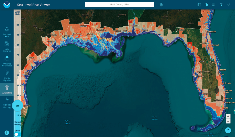
SOURCE: Office for Coastal Management. (2023d). Sea Level Rise Viewer: Gulf of Mexico Vulnerability, 2’ Water Level. https://coast.noaa.gov/slr/#/layer/vul-soc/2/9785443.24747092/3371743.335002211/7/satellite/none/0.8/2050/interHigh/midAccretion
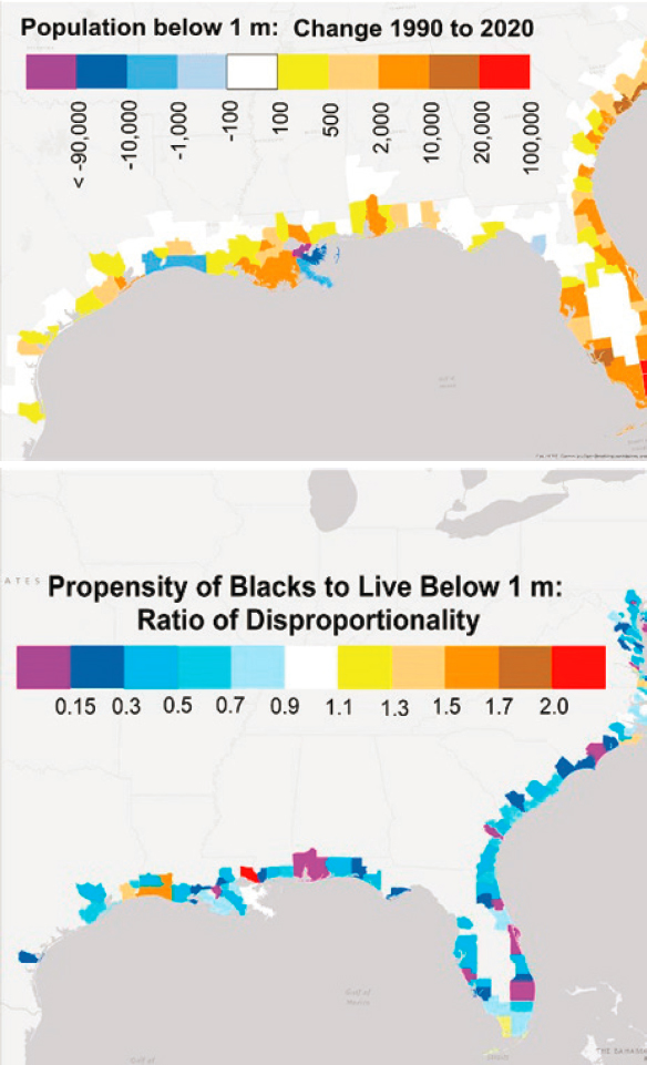
SOURCE: Titus, J. G. (2023). Population in floodplains or close to sea level increased in U.S. but declined in some counties—especially among Black residents. Environmental Research Letters, 18(3), 034001. https://doi.org/10.1088/1748-9326/acadf5
the location of people at risk (see Figure 2-16). Both maps clearly show that at-risk minority populations have been disproportionately impacted.
Growing Populations in Areas Susceptible to Environmental Hazards
Between 2000 and 2016, the Gulf Coast also had the fastest population growth among U.S. coastal regions at a rate of 24.5 percent, compared to 14.8 percent for the United States as a whole (Cohen, 2018). The region’s population increased by over 3 million people, 1.2 million of whom are or were in Harris County, Texas, which includes Houston. This region (as with other coastal regions in the United States) is also more diverse than the United States as a whole, with 47.9 percent of people on the Gulf Coast identifying as something other than non-Hispanic White compared to 38.7 percent in the United States as a whole (Cohen, 2018). While varying somewhat across the Gulf, combinations of multiple hazard risks and social vulnerabilities increase overall vulnerabilities (Oxfam, 2012).
SUMMARY
Climate changes in the U.S. Gulf Coast Region are compounded by existing environmental toxins and socioeconomic stressors, while future climate impacts threaten to exacerbate these stressors. The scale of the threat of displacement looms large and will disproportionately impact vulnerable communities. However, this threat is poorly understood by decision makers and communities. As reflected in the growing literature on the importance of participatory planning, particularly community-led initiatives, addressing Gulf regional risks requires new thinking beyond traditional planning processes and creative ways of leveraging existing federal and state programs, policies, and resources. (These topics are discussed in detail in Chapter 9.) Even with limited modeling available, it is clear that the scale of the current threats to the Gulf Coast far exceeds readiness to respond. The Community-Driven Relocation Subcommittee,8 co-led by FEMA and the U.S. Department of the Interior and launched by the White House in 2022, works across multiple agencies to address programs like hazard mitigation assistance and buyouts. However, the Gulf region lacks a more comprehensive approach, including a multi-scalar and cross-jurisdictional planning response. These challenges are not unique to the Gulf. The next chapter discusses these challenges, and more, by examining historical and current case studies of relocations from the United States and abroad and
___________________
8More information about the Community-Driven Relocation Subcommittee is available at https://www.fema.gov/fact-sheet/fema-efforts-advancing-community-driven-relocation
identifying lessons learned that might be applied to future community-driven relocation efforts.
CONCLUSIONS
Conclusion 2-1: Future Gulf Coast displacements are difficult to project because few models exist to fully characterize the extent of regional risks from climate changes, subsidence, and industrial impacts. Lacking more accurate exposure and risk estimates at the scale of population displacement, the Gulf Coast currently fails to hold a shared understanding of its risks and the enormity of the planning challenges that it faces. Recognizing the scale of threat warrants the equivalent of a regional displacement vulnerability risk assessment and resulting preparations for region-wide population and industry relocations.
Conclusion 2-2: As elsewhere in the United States, recent Gulf Coast displacements occur within the context of the histories of injustices in the region, requiring ever more thoughtful approaches to discussions about risks and potential plans to reduce those risks. Understanding these inequities and their continued and pervasive impact on regional investments reinforces the knowledge that community well-being must be at the center of efforts to address risks.


