Prevention and Mitigation of Bridge and Tunnel Strikes (2025)
Chapter: Appendix B: Technical Memorandum: Data Needs and Sources
APPENDIX B
Technical Memorandum: Data Needs and Sources
BrTS Strike Data
BrTS strikes include multiple types of bridges (e.g., bridges over/under highways, railways, or waterways) and involve various components of a bridge/tunnel being struck by a motor vehicle (in particular, a truck). Reportable BrTS crash data are the most important data source, and they include crash events collected by law enforcement that are filed on an official motor vehicle crash report. BrTS strike data are also collected by the public and private sectors (e.g., toll authorities).
Overview of Reportable BrTS Crashes
The crash report form varies by state in terms of reporting threshold and specific data fields and attributes. To encourage greater uniformity, NHTSA developed MMUCC as a voluntary data collection guideline. According to the MMUCC 5th Edition (2017), a bridge hit can be identified by appropriate data fields (e.g., bridge upper structure, bridge support or pier, bridge rail) along with a bridge/structure identification number that is “linkable to the NBI”. Other standard crash data fields include crash time, location, type, injury severity, sequence of events, first and most harmful event, and so on. If a valid bridge ID (or latitude and longitude) is available, the crash database can be linked to NBI where detailed bridge information (i.e., vertical clearance) is available.
Relevant Crash Data Fields and Attributes in MMUCC
In MMUCC, relevant crash data elements and attributes are listed in Table B1. An example is given in MMUCC 5th Edition in Figure B1 Sequence of Events.
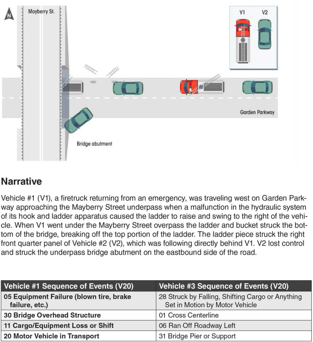
Table B1. Highly Relevant Crash Data Fields and Attributes in MMUCC for BrTS
| Data Field | Description |
|---|---|
| Bridge/Structure ID | A unique federal inspection/inventory identifier assigned to a bridge, underpass, overpass, or tunnel that is also linkable to the NBI. Note in Roadway Data Element, the MIRE Guideline complements MMUCC and greatly expands on the number of MMUCC Roadway Data Elements. |
| Collision With Fixed Object8 |
A motor vehicle in transport strikes an impact attenuator/crash cushion, bridge overhead structure, bridge pier or support, bridge rail, culvert, curb, ditch, embankment, guardrail face or end, concrete traffic barrier, standing tree, utility pole/light support, traffic sign or signal support, fence, mailbox, or other fixed object.
|
| Vehicle Type9 | Includes three subfields. Subfield 1 captures the Body Type Category including values for single unit trucks and truck tractors, and other trucks. Subfield 2 captures the number of trailing units (if this is a combination vehicle). Subfield 3 captures vehicle size in units of Gross Vehicle Weight Rating for single unit trucks and other body types and Gross Combination Weight Rating for combination vehicles or any vehicle with a trailing unit. |
| Other Data Elements | All standard crash data fields are available such as crash time, location, injury severity, weather, pavement condition, and contributing factors for the environment, vehicle, and driver, signage information. |
Reportable BrTS Crash Data at State DOTs
MMUCC is a voluntary guideline, meaning states are free to adopt (or not adopt) any of its data element definitions. Therefore, crash reports in each state can vary from the MMUCC significantly in that they may lack the element entirely, they may have different attributes for an element that has the same or a similar label, or they can exactly match the MMUCC attribute list. For example, all states have data elements that record harmful events; not all will match the MMUCC data elements exactly, but they likely will include “collision with fixed objects” among the attributes of elements for: 1) first harmful event in the crash; 2) sequence of events for each vehicle; and 3) most harmful event for each vehicle. Though states might report on detailed information such as bridge rail strikes, abutments, etc., it should be noted that MMUCC does
___________________
8The same information on “Collision With Fixed Object” appears in multiple places in a MMUCC crash report recorded in both crash and vehicle levels: 1) Crash Data Elements, C7: First Harmful Event; 2) Vehicle Data Elements: V20. Sequence of Events - Collision with fixed object; and 3) V21. Most Harmful Event for this Motor Vehicle - Collision with fixed object.
9V8. Motor Vehicle Body Type Category. In particular, Subfield 3 is about Vehicle Size Note: GVWR is used for single-unit trucks and other body types. GCWR is used for combination trucks or any vehicle with a trailing unit.
- Light (Less than 10,000 lbs. GVWR/GCWR)
- Medium (10,001 – 26,000 lbs. GVWR/GCWR)**
- Heavy (Greater than 26,000 lbs. GVWR/GCWR)**
not distinguish “tunnel” elements versus “bridge” elements. Also, crash data maintained by some states might provide more detailed and accurate information than MMUCC.
WisDOT has made substantial improvements to their motor vehicle crash report form to be more compatible with the MMUCC 5th Edition. The new form, DT4000, was piloted in 2018 and used statewide in 2019. In DT4000, a crash involving a bridge or a tunnel can be identified by “ATCODE” (a code used to identify the type of “structure number” associated with a crash location such as B-Bridge or R-Railroad) and the structure number associated with a crash location is identified as “ATNMBR”.
In DT4000, a bridge collision can be further identified by data fields: MOSTHARM - Event that resulted in the most severe injury or, if no injury, the greatest property damage involving this motor vehicle and SEQEVT[A,B,C,D] - The first four events (A-D) in the sequence of events related to this motor vehicle, including both non-collision as well as collision events. Both fields are recorded at vehicle level which maps to MMUCC (i.e., Vehicle Data Elements: V20. Sequence of Events - Collision with fixed object; and V21. Most Harmful Event for this Motor Vehicle - Collision with fixed object) The relevant attributes are: Bridge Parapet End, Bridge/Pier/Abut, Bridge Rail, and Bridge Overhead Structure. Moreover, Wisconsin uses BadgerTraCS, which has a consistently high level of edit checks that probably matches or exceeds those recommended in the MMUCC 5th Edition.
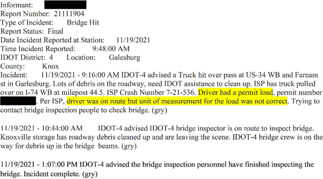
The crash narrative in a report may provide additional information. Figure B2 shows a crash report sent to a permit department in Illinois in which the cause of the bridge strike is due to the incorrect unit of measurement for the load.
In order to gain better information of how BrTS crashes are reported, the project team contacted safety experts from 46 states. Our preliminary screen includes the following five questions.
- Can you directly query bridge strikes by motor vehicles (esp. trucks) from your crash data fields and/or attributes?
- Can you directly query tunnel strikes by motor vehicles (esp. trucks) from your crash data fields and/or attributes?
- If the answer is yes, is the area of a structure (e.g., bridge pier or abutment/support, bridge parapet end, bridge rail, and bridge overhead structure) struck by a motor vehicle identifiable?
- Is the structure ID available?
- Is there any driver permit information (e.g., oversize, overweight) available for the involved motor carrier, such as citations for non-permitted commercial vehicle (CMV) drivers?
Table B2 summarizes the responses from 33 out of 46 states and Table B3 provides more details. The result shows that most states can directly query crashes involving bridge strikes, as well as the part of a structure being struck. Additionally, five states (i.e., NC, NY, MO, WY, AL) can query tunnel strikes from “fixed objects”. Although only four states (i.e., NC, NY, MO, WI) stated that the structure ID is available in the crash database, most responders are positive about identifying the location of a bridge based on coordinates or linear referencing systems. The preliminary screen suggests it is possible to collect BrTS data from many states given the data availability. This information is valuable for the project team to design a feasible data collection plan.
States can locate crashes on their linear referencing systems (LRS). If the structures are properly located on the LRS and the crash location procedures are accurate, this process should work even in the absence of reliable bridge numbers. Most states do have: (a) good bridge inventory data, (b) good roadway inventory data, and (c) established processes for crash location using the same LRS as the roadway inventory. Moreover, increasing use of electronic reporting by most states means crash narratives are available for at least some (if not all) of the crash reports. A text search for key words (bridge, tunnel, rail, etc.) would identify a subset of crash reports that could be examined in detail. Though a more manual process of review is needed to obtain the information, it would result in a short list of crashes involving a bridge or tunnel.
Table B2. Summary of the BrTS Crash Data Inquiries
| States inquired | 1. Can you find any bridge strikes by motor vehicles (esp. trucks)? | 2. Can you find any tunnel strikes by motor vehicles (esp. trucks)? | 3. If the answer is yes, is the part of a structure struck by a motor vehicle identifiable? [Bridge] | 3. If the answer is yes, is the part of a structure struck by a motor vehicle identifiable? [Tunnel] | 4. Is the structure ID available? |
|---|---|---|---|---|---|
| NC | √ | √ | √ | √ | √ |
| NY | √ | √ | √ | √ | √ |
| MO | √ | √ | √ | √ | √ |
| WY | √ | √ | √ | √ | × |
| AL | √ | √ | √ | √ | × |
| MA | √ | √* | √ | × | × |
| TX | √ | √* | √ | × | × |
| FL | √ | √* | √ | × | × |
| CT | √ | √* | √ | × | × |
| NV | √ | √* | √ | × | × |
| SC | √ | √* | √ | × | × |
| UT | √ | √* | √ | × | × |
| ME | √ | √* | √ | × | × |
| WI | √ | √* | √ | × | √ |
| KY | √ | √* | √ | × | × |
| MI | √ | √* | √ | × | × |
| OH | √ | √* | √ | × | × |
| AR | √ | √* | √ | × | × |
| NE | √ | √* | √ | × | × |
| GA | √ | √* | √ | × | × |
| AZ | √ | √* | × | × | × |
| PA | √ | √* | × | × | × |
| NJ | √ | √* | × | × | × |
| VA | √ [Tunnel, Bridge, Underpass, Culvert, etc.] | × | × | × | |
| IL | “Collision with fixed objects” but not specify the type | × | × | × | |
| MD | √ [bridge or overpass] | × | × | × | |
| CA | × | × | × | × | × |
| ND | Information provided is related to FARS and MCMIS, not specific information regarding NDDOT maintained crash data is provided. | ||||
| TN | No response | ||||
| ID | No response | ||||
| HI | No response | ||||
| CO | No response | ||||
| AK | No response | ||||
* Tunnels are considered as other fixed objects in “collision with fixed objects”.
Table B3. Responses to Inquiry of Bridge and Tunnel Crash Data from Each State
| State | 1. Can you find any bridge strikes by motor vehicles (esp. trucks)? | 2. Can you find any tunnel strikes by motor vehicles (esp. trucks)? | 3. If the answer is yes, is the part of a structure struck by a motor vehicle identifiable? | 4. Is the structure ID available? | 5. Is there any driver permit information (e.g., oversize, overweight) available for the involved motor carrier, such as citations for non-permitted CMV drivers? (the notion is that most strikes are committed by non-permitted drivers). | 6. Is crash narrative available for more detailed information? |
|---|---|---|---|---|---|---|
| AL | For Q1 and Q2, YES, in the crash schema, refer to “E Type of Roadway Junction/Feature”, which includes “2 Bridge/Overpass/Underpass” and “10 Tunnel’. | There is no additional information for the tunnel, but there is some information for bridge-related crashes, which can be found in “First Harmful Event” and “Most Harmful Event”, including “30 Collision with Bridge Abutment”, “Rail 31 Collision with Bridge Support”, and “Column 32 Collision with Overhead Object/Bridge/Tree”. | No | YES, please refer to “CU Oversized Load Requiring Permit” and “CU Had Oversized Load Permit”. In addition, overweight can be found in “CU Citation Issued”, which is “Overweight Truck”. | I did not notice any detailed crash narratives in the crash data that are shared with us for general research. There is a chance that such information is classified and requires a special data request under a funded project. | |
| TX | BRIDGE_DETAIL_ID; BRIDGE_IR_STRUCT_FUNC_ID; BRIDGE_RTE_STRUCT_FUNC_ID; BRIDGE_SRVC_TYPE_ON_ID; BRIDGE_SRVC_TYPE_UNDER_ID Regarding trucks versus passenger cars, we need to look into the unit file. We will use vehicle body style to classify. However, the definition of truck is very broad. We use a specific definition in Texas. We have a separate file for citations as well so we can get what you are asking for | OBJ_STRUCK_ID | I check the file, I cannot find | We have a separate file for citations as well so we can get what you are asking for | Not sure | |
| VA | “First Harmful Event” - 7. Tunnel, Bridge, Underpass, Culvert, etc. | Though the data has “FIRST_HARMFUL_EVENT_LOC” in place, but not specify the part of a structure struck by a motor vehicle in the data | No. | Maybe available from DMV regarding driver information | No. | |
| CT | Yes. bridge strikes can be identified by using the “First Harmful Event” filed. The type of vehicles (PC vs. Truck) can also be identified by further querying the vehicle information for each crash. | The tunnel strikes are categorized in the same crash category with some other crashes, which might not be straightforward to be extracted. | Yes. “Bridge Overhead Structure”, “Bridge Pier or Support” and “Bridge Rail” are identifiable in crash data. | No. | Only citation information for alcohol and drug is included in CT crash data. Regarding the driver permit information, there is one field in the person file called “Driver License Jurisdiction” which contains a category “Not Licensed”. It might be possible to use it with the vehicle type to identify any non-permitted CMV drivers. Other than that, no further information for driver permit information is provided in the crash data. | We do have the crash narrative stored in our internal crash database, but that information is currently not available to the public. Initially we deidentified the narrative using the NLP and made it to the public. Later on, some CTDOT departments have concerns about that and we have to take the narrative off from the crash repository that is open to the public. |
| NC | Yes, there is a place on the crash report form (field 69 Road | There is a place in field 69 “Road Feature” to indicate whether it involved | The possible values that can go in fields (52 Crash Sequence-First | Yes, we could determine the structure ID if it is a bridge, but it would not be from the crash | There is a field (83 Overwidth Permit #) for this information | Yes, we have the text of the crash narratives |
| State | 1. Can you find any bridge strikes by motor vehicles (esp. trucks)? | 2. Can you find any tunnel strikes by motor vehicles (esp. trucks)? | 3. If the answer is yes, is the part of a structure struck by a motor vehicle identifiable? | 4. Is the structure ID available? | 5. Is there any driver permit information (e.g., oversize, overweight) available for the involved motor carrier, such as citations for non-permitted CMV drivers? (the notion is that most strikes are committed by non-permitted drivers). | 6. Is crash narrative available for more detailed information? |
|---|---|---|---|---|---|---|
| NC | Feature) to indicate that a bridge strike was involved. Using the vehicle level crash sequence fields (52 Crash Sequence-First Event for This Unit; 53 Crash Sequence-Second Event; 54 Crash Sequence-Third Event; 55 Crash Sequence-Fourth Event; 56 Most Harmful Event for This Unit), we could tell if it was a truck that struck the bridge. | a “tunnel”, but I cannot say with certainty how accurate this might be. | Event for This Unit; 53 Crash Sequence-Second Event; 54 Crash Sequence-Third Event; 55 Crash Sequence-Fourth Event; 56 Most Harmful Event for This Unit) include values like “Bridge rail end” and “Bridge rail face”, but I cannot say with certainty how accurate this might be or how consistently it is filled out. | report form. We would determine that by locating the crash to the roadway, and then using the location cross referenced with our bridge inventory to determine which bridge was involved. | on the second page of the form, but I cannot say with certainty how often this is filled out when it should be. We think that our highway patrol might do this pretty consistently, but maybe not the municipal law enforcement agencies. | available as electronic text. |
| UT | Bridge-related crashes can be identified by one or more of the following attributes (in parenthesis is the number of crashes a given attribute on the first harmful event field from about 11 years of data): - First harmful event, most harmful event, or any event in the sequence of events: - Bridge rail (152) - Bridge pier or support (120) - Bridge overhead structure (161) The “Road Junction or Feature” shows if the location of a crash is near or at a bridge, but it does not necessarily indicate a collision involving the bridge structure (probably not a good parameter to filter by). | No specific coded item identifying tunnel crashes in our crash report. Searching by narrative I only see a few records with the word “tunnel”, and maybe a handful per year that may actually be related to a tunnel. | The three standard parts of the structure indicated by coded values can be identifiable (Bridge rail, bridge pier or support, and bridge overhead structure). Other details can be extracted from the narrative. | The structure ID is not readily available from the crash report. However, using the narrative and other location attributes, the structure ID could be matched to the state’s inventory with some postprocessing. | I don’t see permit information coded in the crash report. Limited data might be received as part of free text in the narrative or the citations, but unfortunately nothing systematically collected on permits. | Crash narratives are available internally for us, but normally restricted to be shared. That being said, in some cases we have manually scrubbed the text, removed personally identifiable information and ultimately shared narratives, so it’s a possibility pending approval from the Highway Safety Office (HSO). For the sample size observed from the quick query on the first harmful events (<500 bridge-related records), we could help with that manual extraction pending approval from HSO. |
| FL |
“Crash Harmful Event” 20 Bridge Overhead Structure 21 Bridge Pier Or Support 22 Bridge Rail (* data field of “Commercial Veh Inv” [Y/N] might be able for identifying truck?) | “Crash Harmful Event” 39 Other Fixed Object (wall, building, tunnel, etc.) | Yes | I don’t see a Bridge Structure ID attribute. My suggestion is to refer to other resources that can be merged together. Here are FDOT GIS database of different types of transportation categories. Bridge information is also listed there. | For the driver permit information and narratives. These should be available in full crash report. However, the full crash report should be requested from FDOT or Florida Highway Safety and Motor Vehicles https://www.fdot.gov/Safety/safetyengineering/crash-data.shtm. We usually granted the access to these data or the database when we have a national/FDOT project and needs FDOT project manager approval. | |
| MA | “Most Harmful Event” Collision with bridge overhead | “Most Harmful Event” Collision with other fixed object (wall, building, tunnel, etc.) | Collision with bridge overhead structure Collision with bridge | No. | Unknown | Unknown |
| State | 1. Can you find any bridge strikes by motor vehicles (esp. trucks)? | 2. Can you find any tunnel strikes by motor vehicles (esp. trucks)? | 3. If the answer is yes, is the part of a structure struck by a motor vehicle identifiable? | 4. Is the structure ID available? | 5. Is there any driver permit information (e.g., oversize, overweight) available for the involved motor carrier, such as citations for non-permitted CMV drivers? (the notion is that most strikes are committed by non-permitted drivers). | 6. Is crash narrative available for more detailed information? |
|---|---|---|---|---|---|---|
| structure Collision with bridge | ||||||
| IL | “collision with fixed objects” but not specify the type | No | No | Unknown | Unknown | |
| CO | Unknown (need to contact CDOT for details) | Unknown | Unknown | Unknown | Unknown | Unknown |
| MO | We’re able to query crashes based on what type of fixed object was struck and what vehicle types were involved. We use the following fixed objects for bridges: Bridge Pier or Abutment/Support, Bridge Parapet End, Bridge Rail, and Bridge Overhead Structure | Missouri has one tunnel. Since we know the location, we can query spatially or by using the travel way and logs, we would also look at fixed objects struck for the crashes at this location. | The current crash report includes the following types of fixed objects related to bridges: Bridge Pier or Abutment/Support, Bridge Parapet End, Bridge Rail, and Bridge Overhead Structure | Yes | Missouri’s crash report includes the type of license the operator has (permit, CDL, unlicensed, expired, etc.). It does not include any citation information. | Unknown |
| ME |
Yes, there are three categories of bridge involved crashes.
| No tunnel strikes (there are not tunnels in the state of Maine) |
| Don’t see an identifier however, each location has a longitude and latitude and could be used to identify location |
Some information about driver’s licenses is available. Likely that information is also available. But I don’t see it in my data. DOT may have more information.
| We have some good details about data but if you need police narratives, I think we need to contact the DOT. I don’t have the police narratives. |
| AZ | Yes, eight crashes with bridge strikes by motor vehicles in 2019. Four of these were passenger car strikes. One was a truck/tractor. Another was a truck with a flatbed or platform for cargo. Another was a truck with garbage or refuse cargo. The last was a truck with no specified cargo information. | None found | Unfortunately, that information isn’t provided. | No | ADOT does not include citation or another other information regarding this unfortunately with the crash data. | It isn’t included in what I have access to. However, I have the incident ID’s available if you would like to try to request those. |
| State | 1. Can you find any bridge strikes by motor vehicles (esp. trucks)? | 2. Can you find any tunnel strikes by motor vehicles (esp. trucks)? | 3. If the answer is yes, is the part of a structure struck by a motor vehicle identifiable? | 4. Is the structure ID available? | 5. Is there any driver permit information (e.g., oversize, overweight) available for the involved motor carrier, such as citations for non-permitted CMV drivers? (the notion is that most strikes are committed by non-permitted drivers). | 6. Is crash narrative available for more detailed information? |
|---|---|---|---|---|---|---|
| PA | Yes there is a flag for hit bridge, and a flag for trucks in the crash database | No. | Cannot tell | Cannot tell | Cannot tell | Yes, it is available, but no this information is not public facing |
| AK | Unknown (need to contact Alaska DOT&PF for details) | Unknown | Unknown | Unknown | Unknown | Unknown |
| NJ | Attached dataset is NJDOT Crashes filtered by “All Vehicle Sequence of Events = Bridge Overhead Structure” However some of the locations don’t look like bridges and may be coded incorrectly. | There is no filter by tunnel. However, there is only one tunnel in NJ managed by NJDOT à https://goo.gl/maps/9vzePkqTqnD3v7Lj8 Tunnels into NYC may be present in their own separate datasets. | The part of the structure hit is not captured in the database. | The structure is not available in the crash database, however a bridge list with Lat and Long can be obtained at https://www.fhwa.dot.gov/bridge/nbi/ascii.cfm and cross referenced. | I have added columns for all relevant information, but the ones requested, Oversize, Overweight, Permit Status, Citations, were not available. | Full crash narratives are not available in the database. |
| NV | V1 All Events or V2 All Events fields ‘BRIDGE OVERHEAD STRUCTURE’, ‘BRIDGE PARAPET END’, ‘BRIDGE PIER OR ABUTMENT’, and ‘BRIDGE RAIL’ | V1 All Events or V2 All Events fields ‘OTHER FIXED OBJECTS (BUILDING, TUNNEL, ETC.)’ | V1 All Events or V2 All Events fields ‘BRIDGE OVERHEAD STRUCTURE’, ‘BRIDGE PARAPET END’, ‘BRIDGE PIER OR ABUTMENT’, and ‘BRIDGE RAIL’ | No, but geocoding is available | Unknown | Cannot release narratives because they may contain personal identifying information |
| HI | Unknown (need to contact HDOT for details) | Unknown | Unknown | Unknown | Unknown | Unknown |
| GA | “Most Harmful Event” (Bridge Rail; Bridge/Pier Abutment; Bridge Overhead Structure; Bridge/Parapet End) | but for tunnel related, key word search did not return any results | for bridge, it should be able to identify | No | Unknown | Unknown |
| TN | Unknown (need to contact TDOT for details) | Unknown | Unknown | Unknown | Unknown | Unknown |
| ND | I always only worked with commercial truck crashes never worked with mote vehicle crash in general. I have two commercial truck crash data sets for ND. One is FARS data and another one is MCMIS data. The data attributes contained in the two data sets are shown in below screenshots. Based on your request, the only possible variable that I think might be useful to you is “first harmful event” from FARS data. Then I run a quick distribution of that variable for ND data, below is what I have. As you can see it did report the other object that the truck struck to and some of them are stationary poles or traffic signs however, I did not see bridge nor tunnel reported. Maybe look at FARS data for the entire USA and not limited to commercial truck might help. Another thing I noticed is it did report “Rollover/overturn” as one first_harmful_event, however we don’t know if the truck hit onto any nearby infrastructures after it overturns. *Information provided is related to FARS and MCMIS, not specific information regarding NDDOT maintained crash data is provided. | |||||
| KY | Yes, by ticking all the options with the word “bridge” under “Event Coll With First” (see attachment 1) and all the options with the word “truck” under “Unit Type Code” (see attachment 2). | No, I don’t see tunnel as a key word | Yes, there are descriptions such as “SLIGHT DAMAGE TO ROCK BRIDGE ABUTMENT” and “DAMAGE TO SUPPORT BEAMS 0-7”. | No, there is not any sign of structure ID in the data. | The only information that I can see related to your question is whether the driver has a CDL or not. In the “Person” tab of the spreadsheet, there is a “HasCDLicense” column which identifies whether the driver has a CDL or not (scroll all the way down to the last row). | Crash Narrative is not part of the publicly available data. |
| MI | Collision With Fixed Object - Bridge Pier/Abutment/Support Collision With Fixed Object - | Not mentioned, probably not? | Collision With Fixed Object - Bridge Pier/Abutment/Support | The structure ID would not be available from the crash database. The DOT would likely have some records, but there are a host of issues I am happy to detail further if you’d | We can get to some general permit-related information. This will take a little bit of a | Yes, we have access to all narratives! You have to limit it so no more than 250 crashes per |
| State | 1. Can you find any bridge strikes by motor vehicles (esp. trucks)? | 2. Can you find any tunnel strikes by motor vehicles (esp. trucks)? | 3. If the answer is yes, is the part of a structure struck by a motor vehicle identifiable? | 4. Is the structure ID available? | 5. Is there any driver permit information (e.g., oversize, overweight) available for the involved motor carrier, such as citations for non-permitted CMV drivers? (the notion is that most strikes are committed by non-permitted drivers). | 6. Is crash narrative available for more detailed information? |
|---|---|---|---|---|---|---|
| MI | Bridge Rail Truck/bus involved separately is doable | Collision With Fixed Object - Bridge Rail | like. (In short, it won’t be easy, and it won’t be complete, and it won’t necessarily match!) | deep dive on my end as I’m not sure how extensive it is. | query...don’t get me started, this is a restriction UMTRI introduced. | |
| OH | 1074 bridge-related crashes in 2018 (285 crashes for trucks) | none in 2018 | yes, for bridge (four location categories: bridge overhead structure, bridge pier or abutment, bridge parapet, and bridge rail) no for tunnel | no, but longitudinal and latitudinal info is available for each crash | not as I know of | not in the crash database, but a link to each original crash report is provided in the database |
| WI | Yes | Yes | Yes | Yes | Yes | Yes |
| NY | Yes | Yes | Yes | Yes | Yes | Yes |
| CA | No way to determine if a vehicle has struck a bridge or a tunnel. The only filter that is available is if a vehicle had struck a fixed object. | No | Unknown | Unknown | ||
| AR | Yes, we can find bridge strikes by motor vehicles, and it is possible to filter those crashes by motor vehicle type such as trucks. This being said, an emphasis is placed on the first harmful event and not necessarily subsequent events. (e.g., A vehicle that first truck another vehicle and then a bridge may simply be labeled as a collision with a motor vehicle and not have the collision with the bridge included.) | We did not find any tunnel strikes by motor vehicles. The data dictionary does not have fields for crashes that involve tunnel strikes. This being said, there may be information included in the narrative, property damage field, or first harmful even section that may identify a tunnel being struck. The issue with this however is it will be near impossible to sort as these are added, written descriptions rather than marking a box or selecting a numerical value that represents a tunnel strike | Yes, the part of a structure struck by a motor vehicle is identifiable. Part of the bridge structure included in data dictionary are overhead structure, pier or support and rail. Additional descriptions may be added by officers if they were to select the ‘other’ option and write out a description, but this is typically not the case and will be difficult to sort for. | No, it is not available. There is no field for structure ID in the crash report | There is a field for driver license class indicating what sort of vehicle they are permitted to drive. For example, driver with license class C is permitted to drive small CMV. There is also a field that indicates what charge was issued to the driver. | There are fields for description of contributing circumstances. For example, one of the crash reports “cargo was too tall”. However, not all crashes have this information. The narrative is available for most reports but varies based on the officer writing it. Another location where information may be added is in the Non-Vehicular property damage section. In the event of a collision with any form of property (possibly including bridges and tunnels), the officer may include additional information including a damage estimate and the owner’s address. |
| NE | Yes | No | Yes | No | No or not sure | Mostly Yes |
| ID | Actually, you need to review the data to determine if the fixed object is a bridge or not. | Unknown | Unknown | Unknown | Unknown | Unknown |
| State | 1. Can you find any bridge strikes by motor vehicles (esp. trucks)? | 2. Can you find any tunnel strikes by motor vehicles (esp. trucks)? | 3. If the answer is yes, is the part of a structure struck by a motor vehicle identifiable? | 4. Is the structure ID available? | 5. Is there any driver permit information (e.g., oversize, overweight) available for the involved motor carrier, such as citations for non-permitted CMV drivers? (the notion is that most strikes are committed by non-permitted drivers). | 6. Is crash narrative available for more detailed information? |
|---|---|---|---|---|---|---|
| WY | Yes, in the crash level report you can find the type of fixed object being struck, in which it includes the four levels provided in the table above with other categories (Bridge Overhead Structure, Bridge Pier or Support, Bridge Rail, and Tunnel). | Yes, we have seven crashes with tunnels by heavy CMV and two with medium CMV from 2010 to 2019. | The provided categories are the only ones related to bridges and tunnels, in which three levels for bridges and one for tunnels. | This information is not provided in the crash data, however, the milepost, date and time are identified. So, it can is easy to identify the bridge or tunnel ID. | There is a variable that could identify if the vehicle was oversized or not, however, none of the crashes above were oversized truck. Information related to permits or citations are not included in the crash reports. | I believe yes! But it is upon request from WYDOT. And I am not sure for how long they archive them. |
| MD | “FIX_OBJ_DESC [bridge or overpass]” “FIX_OBJ_CODE” but not able to distinguish the bridge and tunnel, and also the struck parts | No | Unknown | Narrative can’t be shared because it might include Personal Identifier Information like name, address, phone number, and tag number. | ||
| SC | First Harmful Event COLLISION WITH FIXED OBJECT 40 BRIDGE OVERHEAD STRUCTURE 41 BRIDGE PARAPET END 42 BRIDGE PIER OR ABUTMENT 43 BRIDGE RAIL | First Harmful Event COLLISION WITH FIXED OBJECT 59 OTHER (WALL, BUILDING, TUNNELL, ETC.) *not possible to distinguish tunnel from others | For bridge, it should be able to identify | No | SCDOT will hide the sensitive data from the narrative and share the publicly known information. | Crash narrative can be available, but we need to request SCDOT |
* Contacted 46 states; received responses from 33 states. States who did not respond include WA, IN, LA, OR, NM, MT, SD, WV, OK, MS, MN, KS, IA
** Due to the interest of time, we did not contact RI, VT, DC, DE, and NH.
Traffic Incident Data/Bridge Inspection Data
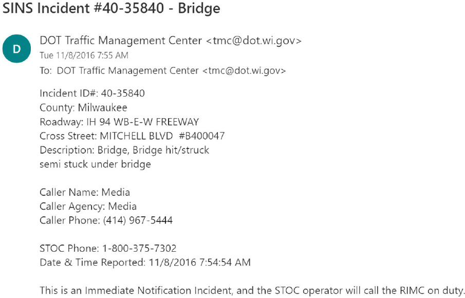
BrTS data can be collected and archived by agencies other than the formal motor vehicle crash report form. For example, during routine bridge inspections by WisDOT bridge engineers, bridge damage cases caused by motor vehicle strikes are often discovered and reported. A bridge strike can also be reported as a real-time incident and entered into traffic incident logs. WisDOT bridge engineers or the OSOW permit unit is usually made aware of structural hits from Division of State Patrol (DSP)/law enforcement through SINS Incident emails (see Figure B3) from the DOT Traffic Management Center.10
After notification, an engineer team will be dispatched to perform a damage inspection and document details in a damage report11. The impact damage may be queried in Highway Structure Information (HSI) through the special notes section. The practice of documenting minor impacts varies from region to region. In the WisDOT S.E. region, an effort is made to enter a damage inspection in HSIS for ever hit, no matter how minor. It is cautioned that the incident data is incomplete. Anecdotally, WisDOT was made aware of bridge hits that aren’t reported to the Traffic Management Center (TMC), sometimes they find out about them from other means and will still have a damage inspection. Other times the responding officer does not report it as a bridge hit or request inspection – this happens often at Mitchell Blvd, where the same City of Milwaukee officers become familiar with the minor hits and don’t report it to TMC. If scrapes of damage are discovered during a normal route, they will be noted in the element notes for the elements that was
___________________
10Edward Lalor, WisDOT permit group under Bureau of Highway Maintenance (BHM) at DTSD. Edward is responsible for posting the vertical clearance data integration into the permit routing system at WisDOT.
11WisDOT Structure Inspection Manual, Chapter 4 Superstructure, page 2-4-28 https://wisconsindot.gov/dtsdManuals/strct/inspection/insp-fm-pt2ch4.pdf,
damaged. However, a term such as “frequent hits” is often used in the route inspection report which does not specify the number of hits.
According to the WisDOT Structure Inspection Manual, Chapter 4 Superstructure “Signs of impact damage include scrapes on member undersides, chips, cracks, spalls, and possibly a broken out section of a member. Particularly strong collisions will expose several reinforcing bars or prestressing strands. Underside scrapes are an indication of vehicle contact with the superstructure, and are typically found above or adjacent to traffic lanes or navigation channels.” If search “impact damage” in Chapter 4 Superstructure, it is mentioned 17 times in pictures, illustrations and texts. Such damages caused by impact or collisions should be recorded in the “condition state commentary”.
In general, WisDOT does not keep a separate log of bridge hits. It is impossible to know the exact number of times a bridge has been impacted by vehicular traffic. Similar on repair costs; if the damage has been found where the repair work is LET, or if an accident claim project has been developed, then the costs for that work could be pulled up. So WisDOT usually doesn’t log such information separately and it’d be difficult to extract that cost data on a network level.
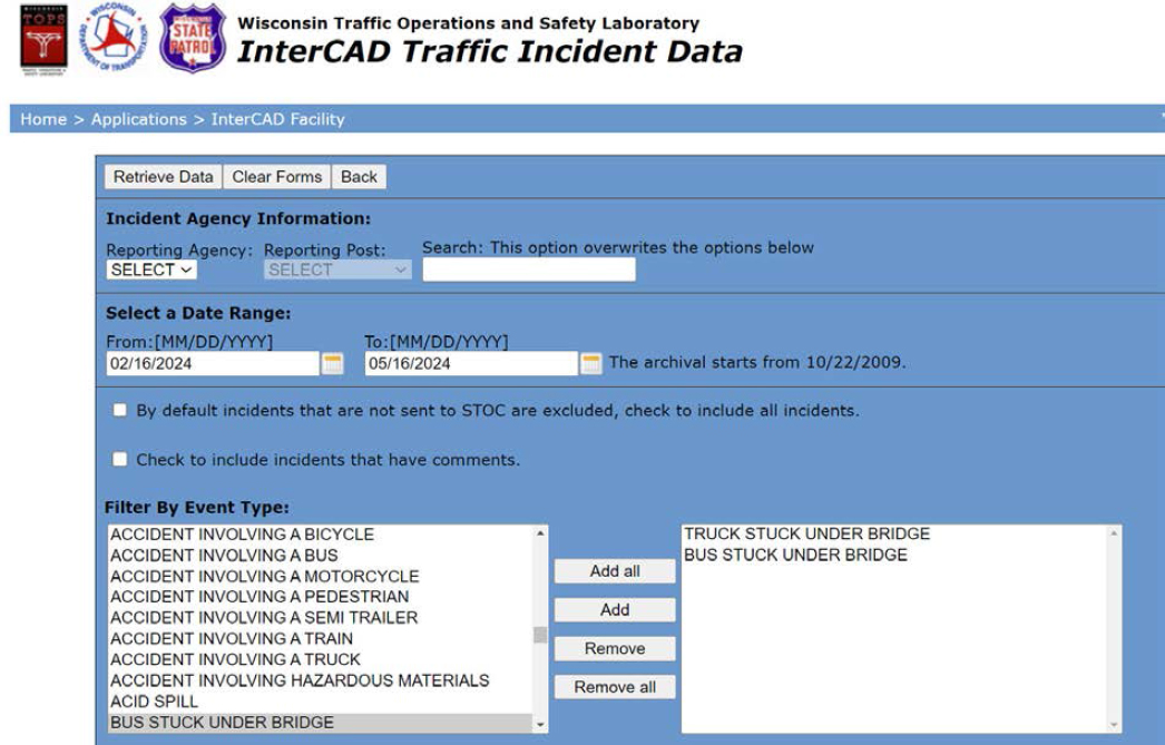
Additionally, these emails are usually sent and logged in the WisDOT InterCAD Traffic Incident Database that is a web-based query and retrieval facility for archived InterCAD traffic incident data. All messages are archived in WisTransPortal on a nightly basis. Messages related to traffic incidents are retained in the archive for long-term research and planning purposes. The WisTransPortal InterCAD system facilitates the real-time exchange of traffic incident data from public safety agency Computer Aided Dispatch (CAD) systems to the WisDOT Statewide Traffic Operations Center Advanced Traffic Management System. Currently, the InterCAD database contains CAD incident data from the Wisconsin State Patrol since October 2009 and more recently from the counties of Waukesha (2012), Dane (2013), and Milwaukee (2013). As shown in Figure B4, incidents such as “truck stuck under bridge” and “bus stuck under bridge” can supplement the BrTS crashes in the crash database. Note that the Event Type selection elements come from IEEE 1512 defined codes. According to IEEE Standards for Common Incident Management Message Sets for Use by Emergency Managements Centers (2006), the alternative rending for “truck/bus stuck under bridge” is “high load hit involving truck/bus”.
However, due to the various levels of filtering and redaction, the InterCAD database may contain incomplete information about a particular traffic incident. Another issue that can occur when crash data are merged with incident data is that an incident may be counted twice due to not knowing that the crash was reportable. Given the limited location information provided in the incident log, an incident case may be linked to a crash if their times and locations match.
NYSDOT maintains a bridge hits database containing information on reported bridge hits. According to a report by (Agrawal, Xu, and Chen 2011), the database contains the following data fields:
- BIN, Span, Region, County, Carried Over, Crossed.
- Date of Collision, Damage, Comments, Collision Class, and Collision Rating.
- Bridge hit data include both crash on bridge and crash under bridge.
- Feature carried under the bridge: reported bridge hits as related to the type of roadway the bridge is over.
- Feature carried on the bridge: reported bridge impacts plotted as related to the type of roadway the bridge is over.
In addition to reportable BrTS, NYSDOT also uses regional “BRIDGE IMPACT REPORT” form from the impact inspection to collect bridge hits data. Figure B5 shows the form.
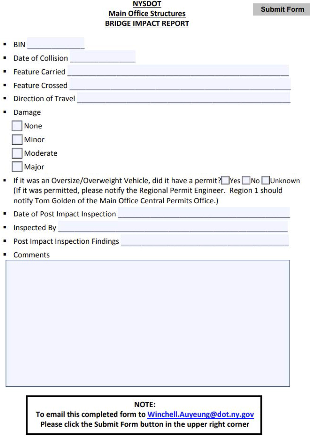
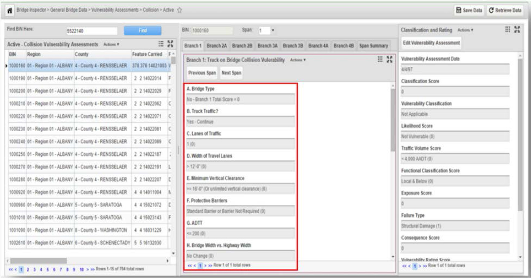
Figure B6 is a screenshot of information from the bridge hits database that is most relevant to BrTS. Additionally, the “BDIS (Bridge Data Information System) User Manual” states (AgileAssets Inc. 2016):
- BDIS provides for assessing bridge vulnerability to the following failure modes: 1. Collision; 2. Concrete; 3. Hydraulic; 4. Seismic; 5. Steel
- The assessment details pane contains the fields corresponding to the rating factors defined in the NYSDOT Collision Vulnerability Manual. This pane is divided into seven tabs, each of which corresponds to a section in the manual dealing with a different type of collision vulnerability (e.g., truck on bridge, pier vulnerability to truck collision, etc.).
Private Sector Data
Private sector entities such as insurance companies and motor carriers may keep their own records for structural strike claims. C.L.U.E. is a claims history database generated by LexisNexis® enabling insurance companies to access consumer claims information when they are underwriting or rating an insurance policy. LexisNexis® C.L.U.E.® Auto is a claim history information exchange containing up to 7 years of personal automobile claims matching the search criteria submitted by the inquiring insurance company. More than 99 percent of insurers writing automobile coverage provide claims data to the C.L.U.E. Auto database.
Data provided in LexisNexis® C.L.U.E.® Auto reports include vehicle information, policy information such as name, date of birth and policy number, as well as claim information such as date of loss, and type of loss and amounts paid.
Vertical Clearance Data
This subsection provides data sources regarding critical bridge/tunnel information, specifically vertical clearance data. The following relevant BrTS data are included: description, general rules, and frequency of measurements and updates.
NBI
The NBI database maintains information about more than 615,000 bridges located on public roads and publicly accessible bridges on federal and tribal lands. NBI keeps inventory and inspection information collected by state DOTs, federal agencies, and tribal governments. The database is used for state-level and national-level analyses and reporting, funding projects, and for accelerating the identification of freight and defense-critical corridors and connectors. The collection of bridge inventory and inspection data are categorized into seven sections: 1) bridge identification, 2) bridge material and type, 3) bridge geometry, 4) features, 5) loads, load rating and posting, 6) inspections, and 7) bridge condition.
Bridge identification information includes a unique number provided by the respective state or agency. It locates the bridges and classifies each into standard categories. The database includes bridge material and type consisting of superstructure/deck, substructure and roadside hardware. Geometry information and features such as route, railroad and navigable waterway are included. The database also includes loads and load rating, inspection data and bridge condition ratings which includes the age of the structure. For example, all information in the Wisconsin NBI is extracted from HSIS. For the most part, the information is identical. There are four bridges on the state border that are in HSIS as having “units” (such as B-16-5-1, B-16-5-2, etc.) that are submitted to FHWA as one structure (such as B-16-5). WisDOT does not submit data for bridges owned by the railroad, only bridges owned by WisDOT and local entities (county, town, city, village) that carry vehicle traffic. There are some railroad bridges in HSIS. However, bridges owned by the railroad are not required to be in HSIS and such data are not maintained, since it may have been entered when the bridge is initially built, and not updated since then. NBI data fields relevant to this project are listed in Table B4.
Regarding the ongoing or proposed efforts to improve the NBI database, a most relevant and recent information that has been found is the one mentioned in FHWA’s “National Bridge Inspection Standards - A Rule by the Federal Highway Administration on 05/06/2022”:
“Fourteen commenters questioned the need for the proposed Maximum Bridge Height item. Multiple commenters also questioned the need to update the reported value for this item when maximum height occurs over water that has a fluctuating bed elevation.
FHWA Response: Bridge height is an attribute that can inform multiple procedures, including inspection planning to identify access equipment needs, seismic vulnerability assessments, and cost estimation associated with work types or needs. To reduce the burden associated with this item, and to facilitate identification of bridges with limited clearance over water, the specification for this item has been revised so that measurement is from the top of deck to the ground line or water surface, whichever yields a higher value.”
Table B4. Most Relevant Data Fields in NBI for BrTS
| Inventory Category | Data Field |
|---|---|
| Bridge Identification | Structure Number (Bridge Number)12 |
| Highway Agency District | |
| County Name | |
| Mile Post | |
| Latitude | |
| Longitude | |
| Year Built | |
| Year Constructed | |
| Bridge Material and Type | Main Span Materials |
| Main Span Design | |
| Number of Spans in Main Unit | |
| Superstructure Configuration | |
| Superstructure Type | |
| Deck Structure Type | |
| Deck Protection | |
| Bridge Geometry | Approach Roadway Width13 |
| Structure Flared | |
| Minimum Vertical Clearance Over Bridge Roadway14 | |
| Minimum Vertical Underclearance | |
| Minimum Lateral Underclearance on Right | |
| Minimum Lateral Underclearance on Left | |
| Pier Abutment Protection | |
| Features | Base Highway Network |
| Bypass or Detour Length | |
| Lanes on the Structure | |
| Lanes under the Structure | |
| Average Daily Traffic | |
| Future Average Daily Traffic | |
| Average Daily Truck Traffic (Percent ADT) | |
| Loads, Load Rating and Posting | Loading Posting Status |
| Inspections | Inspection Date |
| Critical Feature Inspection | |
| Bridge Condition | Deck Condition |
| Superstructure | |
| Condition | |
| Substructure | |
| Condition | |
| Underclearance | |
| Appraisal | |
| Vertical | |
| Horizontal |
___________________
12A 15-digit structure number unique for each bridge within the state. It can be linked to other data set such as crash data.
13Normal width of usable roadway approaching the structure measured in meters.
14The actual minimum vertical clearance over the bridge roadway, including shoulders, to any superstructure restriction, measured in meters.
NTI
The NTI database was established by the FHWA to track the conditions of tunnels throughout the United States and to ensure compliance with the NTIS by containing all of the initial tunnel inventory and inspection data (FHWA, 2015). The inventory and inspection data will be available in the annual report to Congress. This data will also allow patterns of tunnel deficiencies to be identified and tracked, which will help ensure public safety. The NTI database provides information for a data-driven, risk-based approach to asset management that can be used for informed investment decisions.
The NTI is a collection of information describing the more than 500 national tunnels located on public roads, including Interstate Highways, US highways, state and county roads, as well as publicly accessible tunnels on Federal lands (FHWA, n.d.). The inventory data present a complete picture of the location, description, and classification data for each tunnel, as well as any load rating and inspection information. The element data present a breakdown of the condition of structural and civil elements for each tunnel on the National Highway System (NHS). The specifications for the NTI contain a detailed description of each data element, including coding instructions and attribute definitions.
NTI includes eight types of inventory items: identification items, age and service items, classification items, geometric data items, inspection items, load rating and posting items, navigation items, structure type and material items. The Routine Inspection Interval is 24 months. Highly relevant NTI inventory items and attributes include those listed in Table B5.
Table B5. Most Relevant Data Fields in NTI for BrTS
| Inventory Category | Data Field |
|---|---|
| Identification Items | Tunnel Number (15-digit number) |
| State, County, Place codes (FIPS codes) | |
| LRS ID | |
| LRS mile point | |
| Tunnel portal’s latitude | |
| Tunnel portal’s longitude | |
| Age and Service | Year built |
| Year rehabilitated | |
| Total number of lanes | |
| ADTT | |
| Detour length | |
| Classification Items | Direction of traffic |
| Geometric Data items | Roadway width |
| Curb-to-curb width | |
| Minimum vertical clearance over tunnel roadway | |
| Inspection Items | Inspection date |
| In-depth inspection | |
| Damage inspection | |
| Special inspection | |
| Load Rating and Posting Items | Height restriction |
| Other restrictions (include width restrictions or requirements for police escorts for permit vehicles) | |
| Structure Type and Material Items | Tunnel shape & portal shape (oval, horseshoe, rectangular, circular) |
| Ground conditions (soil, rock, mixed face) | |
| Navigation Items (non-relevant) |
Bridge and Tunnel Inventory Practices at State DOTs
State DOTs collect clearance data on every bridge in the state to meet federal reporting requirements and to inform infrastructure improvement needs. State DOTs are obligated to report bridge clearance measurements to NBI as part of the federal requirements. New construction, rehabilitation, and repairs can change bridge clearances, so measurements must be taken consistently to accurately support oversize/overweight permitting and other processes.
Many state DOTs provide specific instructions on how and when clearance information should be measured. Iowa DOT states (Iowa DOT, 2021): “The Vertical & Horizontal Clearance Form should be used to record all new restrictions or any revisions you need to make to existing clearances. Clearances reported on this form are created by structures, truss bridges, pedestrian bridges, skywalks or railroad bridges. Revisions could be due to reconstruction, resurfacing, pavement upheaval, beam repairs or structure deterioration.” “The vertical clearance is measured from the road surface to the lowest point of the structure crossing overhead (or the superstructure if a high truss bridge). Clearance information must be measured at the Left Edge of Pavement, each Lane Line Marking from left to right, and Right Edge of Pavement at the entrance to, middle of, and exit from the underpass or high truss bridge. Thus, the least clearance from these measurements is used to determine the vertical clearance of the structure”.
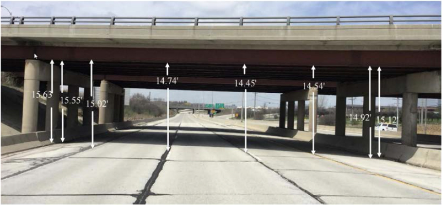
WisDOT states, “Clearances should be taken in every lane, at edge of lanes, edge of paved shoulders, and at barrier edges to determine the low point for vehicular travel”, as shown in Figure B7. “This activity shall be completed every time there is a construction project on or under a bridge. In addition, after a bridge is hit the inspector conducting the damage inspection should determine if they need to re-measure clearances and if so, enter a vertical clearance verification along with the damage report” (WisDOT, n.d.). Additionally, in Wisconsin, bridge vertical clearance is usually initially measured from design plans, then manually verified by bridge inspector after construction is complete and all clearances are entered into HSIS. For a bridge with low vertical clearance, or changed vertical clearance (due to resurfacing project, for example), bridge inspectors and region bridge maintenance engineers are responsible for sending or sharing the information with traffic operations so that a bridge sign for vertical clearance can be replaced or updated. The Bridge Maintenance Engineers would notify the Region signing coordinator when the new measurements are taken. Region Signing Coordinators order the signs from Bureau of Traffic Operations. Typical timeframe to get them manufactured and installed is 4-6 weeks. If needed, they can be expedited in emergency. Traffic signs can be stored in two separated systems, depending if a sign is on a bridge or on a roadway. If it is on a bridge, it is stored in HSIS; otherwise, it is in the roadway sign inventory. WisDOT has a geolocated roadway sign inventory, Traffic Operations Asset Management System.
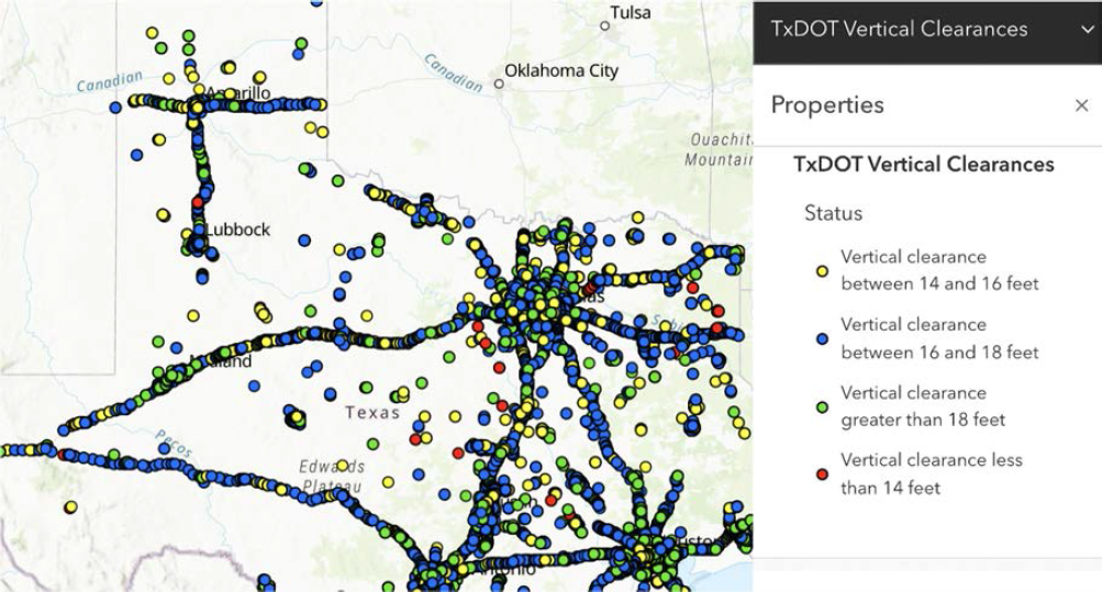
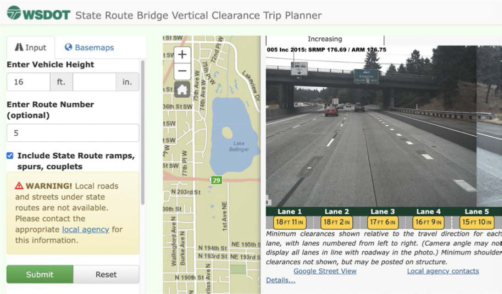
Most state DOTs provide online vertical clearance via a log, a table or a list; some publish a static bridge clearance map (in pdf or other forms), and a few, including Iowa, Indiana, Texas, Washington, Illinois, New York, Alabama, Kentucky, Colorado and Idaho developed an interactive online GIS map free to the public (see Figure B8). Most state DOTs give only the minimal clearance information, but a few states such as Washington provide lane-specific vertical clearance information as shown in Figure B9.
Data quality assurance and requirements vary by state. Some state DOT measure and update bridge vertical clearance only on an as needed basis (i.e., new construction, rehabilitation, or repairs). Some states measure and update the information more frequently. According to Texas DOT, “All vertical clearance measurements of grade separation structures should be verified at least once a year. The measurements taken for “Actual Clearance,” “Signed Clearance,” type of work performed and when it was done should be reported to the Motor Carrier Division and the district bridge inspection coordinator.” (TxDOT, n.d.). WSDOT “recommends use of this interactive map, when possible, mostly because vertical clearance information is regularly updated as a part of bridge inspections. Changes to vertical clearances in the interactive map are updated daily, whereas the clearance information available in this Bridge List is static until a newer edition is published, approximately once per year.”
Some state DOTs check the discrepancies between state bridge data and NBI. Iowa DOT states that the supervisor “will compare the Independent Oversight Model inspections to the NBI inspection reports the team submits and prepare a summary of any differences between the reports” (Iowa DOT, 2015). More specifically, the procedure requires the supervisors to examine consistency in NBI ratings, Bridge Element condition states, sketches, and photographs to determine if data are in-tolerance or out-of-tolerance.
One notable difference is the different techniques and methods used to measure structural vertical clearance data. Some are manually measured from design plans or manually measured by Laser; others use Lidar technology to automatically extract clearance information. Another notable difference lies in how a bridge vertical clearance is signed. In Texas, “In locations where an encroachment over the usable shoulder would significantly reduce the vertical clearance, two clearances may be shown. The travel lane and shoulder clearances should be signed independently on the structure.” The Indiana DOT says, “the roadway may be signed for a lower clearance. Many bridges in Indiana are signed 2 or 3 inches lower than the actual low clearance to factor in snow/ice pack during winter months”. An internet search has also been conducted to explore the measurement and collection of vertical clearance information by each state in the US, and detailed results could be referred to Table B6.
Table B6. States’ Practice on Collecting and Managing Bridge Clearance Data
| Agency | Database Name | Bridge clearance measurement | Accuracy Requirement | Recording Lane-specific vertical clearance during inspection | Lane Specific in the database | Data Collection Frequency | Frequency to update the clearance database | Accessible | GIS capabilities? | ||
|---|---|---|---|---|---|---|---|---|---|---|---|
| Design Plans | Measured by Inspectors | Measured by Consultant | |||||||||
| Iowa DOT | Structure Inventory and Inspection Management System (SIIMS)/Roadway Asset Management System (RAMS) | - | - | mobile Lidar | ±3 inch | Yes | No | New or any Revisions | Annually (log) | To the public | GIS map with minimal vertical clearance |
| Indiana DOT | INDOT Bridge Inspection Application System (BIAS) | X | X | mobile Lidar | ±1 inch | Yes | Yes | Every 2 years | As Needed | To the public | Interactive GIS map with all the clearances |
| Wisconsin DOT | Wisconsin HSI | - | - | - | - | Yes | No | New or any Revisions | As needed | To the public | No |
| Texas DOT | TxDOT Bridge Inspection Management System (BIMS) | - | - | mobile Lidar | - | - | No | Annually or any revisions | As needed | To the public | Interactive GIS map with vertical clearance Intervals |
| Washington DOT | Washington State Bridge Inventory System (WSBIS) | - | - | mobile Lidar | - | Yes | Yes | 1) 8 year (<=16.5 ft); 16 year (>16.5 ft) or 2) any revisions | Daily (interactive map) or annually (Bridge List) | To the public | Interactive GIS map with lane-specific vertical clearances |
| Utah DOT | UDOT Bridge Management System (BMS) | - | - | mobile Lidar | - | - | - | - | - | - | No |
| Arizona DOT | ADOT Bridge Inventory Database | - | Tape measures, survey rods, lase distance finders | - | - | - | - | - | - | To the public | No (only table with minimal vertical clearance) |
| Ohio DOT | ODOT AssetWise System (AWS) | - | - | mobile Lidar | - | - | - | - | - | - | No |
| Florida DOT | FDOT Bridge Management System (BMS) | - | - | - | 1 inch | - | - | - | - | - | No |
| Agency | Database Name | Bridge clearance measurement | Accuracy Requirement | Recording Lane-specific vertical clearance during inspection | Lane Specific in the database | Data Collection Frequency | Frequency to update the clearance database | Accessible | GIS capabilities? | ||
|---|---|---|---|---|---|---|---|---|---|---|---|
| Design Plans | Measured by Inspectors | Measured by Consultant | |||||||||
| California DOT | Caltrans Structure Maintenance and Investigations (SM&I) Database | - | - | mobile Lidar | - | - | - | - | - | - | No |
| Tennessee DOT | TDOT Bridge Management System (BMS) | - | - | mobile Lidar | - | - | - | - | - | - | No (only table with minimal vertical clearance) |
| Hawaii DOT | HDOT Bridge Management database (BrM) | - | - | mobile Lidar | - | - | No | - | As needed | To the public | No (GIS map with no clearance information) |
| Nevada DOT | NDOT Bridge Management database (BrM) | - | - | mobile Lidar | - | - | - | - | - | - | No |
| Connecticut DOT | ConnDOT AssetWise System | - | - | mobile Lidar | - | - | - | - | - | - | No |
| North Dakota DOT | NDDOT Bridge Management database (BrM) | - | - | - | - | - | - | - | - | - | No (only table with minimal vertical clearance) |
| Minnesota DOT | MnDOT Structure Information Management System (SIMS) | - | - | - | - | - | No | - | As needed | To the public | Interactive GIS map with NBI clearances |
| Michigan DOT | MDOT MiBRIDGE | - | - | mobile Lidar | - | - | - | - | - | - | No |
| Illinois DOT | IDOT Structure Information Management System (SIMS) | - | - | - | - | Yes | No | - | As needed | To the public | Interactive GIS map with most NBI information |
| New York DOT | NYDOT BDIS | - | - | - | - | - | No | 1) 6 years (<=25 ft); no direct measurement (>25 ft) or 2) any revisions | As needed | To the public | Interactive GIS map with minimal vertical clearance |
| Alabama DOT | ALDOT Maintenance Management System (MMS) | - | - | - | - | - | No | - | No frequency or cycle for inspection | To the public | Interactive GIS map with minimal vertical clearance and horizontal clearance |
| Agency | Database Name | Bridge clearance measurement | Accuracy Requirement | Recording Lane-specific vertical clearance during inspection | Lane Specific in the database | Data Collection Frequency | Frequency to update the clearance database | Accessible | GIS capabilities? | ||
|---|---|---|---|---|---|---|---|---|---|---|---|
| Design Plans | Measured by Inspectors | Measured by Consultant | |||||||||
| Nebraska DOT | Nebraska DOT Bridge Management database (BrM) | - | - | - | - | - | - | - | - | - | No |
| Rhode Island DOT | Rhode Island DOT Bridge Management database (BrM) | - | - | - | - | - | - | - | - | - | No |
| Alaska DOT | Alaska DOT Bridge Management database (BrM) | - | - | - | - | - | - | - | - | - | No |
| South Carolina DOT | SCDOT Bridge Management System (BMS) | - | - | - | - | - | - | - | - | - | No |
| Kansas DOT | KDOT Bridge Management database (BrM) | - | - | - | - | - | No | - | As needed | To the public | GIS map with minimal vertical clearance |
| New Hampshire DOT | NHDOT Bridge Management System (BMS) | - | - | - | - | - | - | - | - | - | No |
| South Dakota DOT | SDDOT Bridge Management database (BrM) | - | - | - | - | - | - | - | - | To the public | No (only table with minimal vertical clearance) |
| Arkansas DOT | ARDOT Bridge Management System (BMS) | - | - | - | - | - | - | - | - | - | No |
| Kentucky DOT | Kentucky Transportation Cabinet (KYTC) | - | Measuring Rod, waders, sounding rods and weighted line | mobile Lidar | - | - | No | - | As needed | To the public | Interactive GIS map with NBI clearances |
| New Jersey DOT | NJDOT Bridge Management database (BrM) | - | - | - | - | - | - | - | - | - | No |
| Louisiana DOT | Louisiana AssetWise System | - | - | - | - | - | - | - | - | - | No |
| New Mexico DOT | Maine DOT Bridge Management database (BrM) | - | - | - | - | - | - | - | - | - | No |
| Agency | Database Name | Bridge clearance measurement | Accuracy Requirement | Recording Lane-specific vertical clearance during inspection | Lane Specific in the database | Data Collection Frequency | Frequency to update the clearance database | Accessible | GIS capabilities? | ||
|---|---|---|---|---|---|---|---|---|---|---|---|
| Design Plans | Measured by Inspectors | Measured by Consultant | |||||||||
| Colorado DOT | Colorado TAM | - | - | mobile Lidar | 1-2 cm | Yes | No | - | As needed | To the public | Interactive GIS map with maximum & minimum vertical clearance |
| Maine DOT | Maine DOT Bridge Management database (BrM) | - | - | - | - | - | - | - | - | - | No |
| Maryland DOT | Maryland Structural Inventory and Appraisal database | - | - | - | - | - | - | - | - | - | No |
| North Carolina DOT | Wearable Inspection and Grading Information Network System (WIGINS) | - | - | - | - | - | - | - | - | - | No |
| Vermont DOT | Vermont Online Bridge Culvert Inventory Tool (VOBCIT) | - | - | - | - | - | No | - | As needed | To the public | Interactive GIS map with minimal vertical clearance |
| Delaware DOT | DelDOT’s Bridge Management database (BrM) | - | - | - | - | - | No | - | As needed | To the public | Interactive GIS map with minimal vertical clearance |
| Massachusetts DOT | MassDOT’s Bridge Inspection Management System (BIMS) | - | - | - | - | - | No | - | As needed | To the public | Interactive GIS map with minimal vertical clearance |
| Virginia DOT | VDOT’s Bridge Management database (BrM) | - | - | - | - | - | No | - | As needed | To the public | Interactive GIS map with minimal vertical clearance |
| Georgia DOT | Georgia DOT Bridge Management database (BrM) | - | - | - | - | - | - | - | - | - | No |
| Oklahoma DOT | Oklahoma DOT Bridge Management database (BrM) | - | - | - | - | - | - | - | - | - | - |
| Agency | Database Name | Bridge clearance measurement | Accuracy Requirement | Recording Lane-specific vertical clearance during inspection | Lane Specific in the database | Data Collection Frequency | Frequency to update the clearance database | Accessible | GIS capabilities? | ||
|---|---|---|---|---|---|---|---|---|---|---|---|
| Design Plans | Measured by Inspectors | Measured by Consultant | |||||||||
| West Virginia DOT | WVDOT Bridge Inventory Data | - | - | - | - | - | - | - | - | - | No |
| Idaho Transportation Department | Idaho’s Bridge Management database (BrM) | - | - | mobile Lidar | - | Yes | Yes | - | As needed | To the public | Interactive GIS map with lane-specific vertical clearances |
| Missouri DOT | MoDOT’s Bridge Management database (BrM) | - | - | mobile Lidar | - | - | No | - | As needed | To the public | Interactive GIS map with minimal vertical clearance |
| Pennsylvania DOT | PennDOT’s Bridge Management System 2 (BMS2) | - | - | - | - | - | No | - | As needed | To the public | Interactive GIS map with minimal vertical clearance |
| Wyoming DOT | WVDOT Bridge Inventory Data | - | - | - | - | Yes | Yes | - | As needed | To the public | No (only table with lane-specific vertical clearances) |
| Montana DOT | MDT’s Bridge Management database (BrM) | - | - | - | - | - | - | - | - | - | No |
| Mississippi DOT | MDOT Public Accountability Transportation Hub (PATH) | - | - | - | - | - | No | - | As needed | To the public | Interactive GIS map with maximum & minimum vertical clearance |
| Oregon DOT | ODOT Bridge Inspection Database | - | - | - | - | - | - | - | - | To the public | No (only table with minimum vertical clearance) |
Other Useful BrTS Data Sources
Although crash data and structure vertical clearance data are the primary sources for analyzing and preventing BrTS, other sources such as driver characteristics and behavior, OSOW permit data, roadway and traffic characteristics, and weather offer valuable perspectives for developing a data-driven method to evaluate the risk of a motor vehicle strike on any single bridge or tunnel.
Driver Characteristics and Behavior, Citation
Data stored in the FMCSA’s SMS were explored for this study. SMS includes data regarding driver and vehicle violations, crash reports from the last 2 years, and investigation results, which are valuable for performing behavior analyses and identifying behavior-based risk factors. SMS is FMCSA’s workload prioritization tool; it assesses compliance and prioritizes carriers for interventions based on their on-road performance and investigation results. FMCSA uses SMS to identify carriers with potential safety problems and intervene as part of the agency’s safety compliance and enforcement program called Compliance, Safety, Accountability. SMS is designed to incorporate the safety-based regulations related to motor carrier operations. On-road performance includes data collected from roadside inspections and crash reports; investigation results include violations discovered within the previous 12 months.
SMS assesses motor carrier on-road performance and compliance by organizing data into seven Behavior Analysis and Safety Improvement Categories (BASICs): Unsafe Driving, Crash Indicator, Hours of-Service Compliance, Vehicle Maintenance, Controlled Substances/Alcohol, Hazardous Materials Compliance (HM), and Driver Fitness. In each BASIC, SMS calculates a quantifiable measure of a motor carrier’s performance. SMS groups carriers by BASIC with other carriers that have a similar number of safety events (e.g., crashes, inspections, or violations). SMS ranks these carriers based on their BASIC measure, assigning them a percentile from 0 - 100 (the higher the percentile, the worse the safety performance). The SMS dataset includes the following components relevant to BrTS analysis and modeling (Table B7).
Table B7. Most Relevant Components in SMS Dataset for BrTS
| Component | Description |
|---|---|
| Violation Summary | Violation Summary / [name of BASIC] Violations – This tab contains a list of violations included in SMS and acquired by any carrier during the past 24 months. This list displays the violation group description, frequency of each violation, the number of Out-of-Service (OOS) violations related to each violation type, and the severity weight (i.e., number of points) of each violation. |
| Inspections/Inspections with Violations/Relevant Inspections | Inspection information contains the details of the inspection report (e.g., date, state, and report number). |
| Measure information shows how the inspection will impact the carrier’s SMS by listing the inspection and violation severity weights and the time weight. | |
| Driver information lists the driver’s name, license number, and state for up to two drivers. | |
| Vehicle information lists the vehicle identification number (VIN), type of vehicle, license plate number, and state for up to two units. | |
| Violation information contains the violation group description, violation code, description, OOS status, and the unit the violation is linked to. | |
| Crash information contains the details of the crash report (e.g., date, state, crash report number, and number of fatalities). | |
| Crashes (this tab contains five types of information about each crash) | Measure information explains how the crash will impact the carrier’s SMS by listing the crash severity weight and time weight. Crashes with a “Yes” in the Not Preventable Flag column are excluded from SMS calculations. |
| Driver information lists the driver’s name, license number, and State. | |
| Vehicle information lists the VIN, state of license plate, and plate number. | |
| Crash environment lists roadway trafficway, road access control, road surface condition, weather condition, and light condition. | |
| Acute-Critical Violations | This tab identifies the investigation type and date and displays a list and description of each Acute/Critical Violation discovered. In the file that includes all BASICs, this tab will also link each Acute/Critical Violation with the BASIC with which it is associated. |
Permit Data
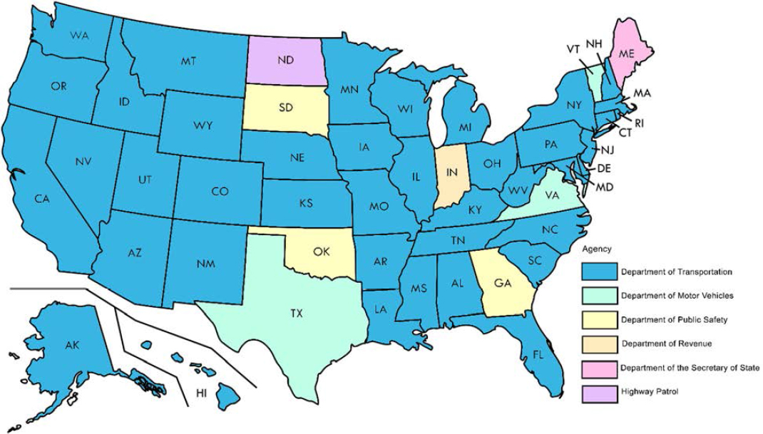
OSOW vehicle routing and permitting is crucial in preventing BrTS because all of the bridge/tunnel vertical clearance data should have been checked against a vehicle’s height, including its loads. However, OSOW permit services can be provided by agencies other than state DOTs who are responsible for measuring, collecting, reporting and updating bridge and tunnel vertical clearance data. Interagency communication is extremely important when bridge and tunnel data are housed in different agencies, as the data need to be accurate and up to date. Figure B10 displays the types of state agencies for OSOW permits based on the review of FHWA’s links to all 50 permit offices (FHWA, n.d.-b).
In Wisconsin, OSOW Permit Unit draws bridge clearance information from a variety of sources. According to Edward Lalor of the WisDOT OSOW permit unit at BHM, the vertical clearance data is integrated into the permit routing system: Superload OSOW permitting and routing system by Bentley). The OSOW Permit unit does at least one full network data draw every spring after the annual State Trunk Highway Network updates have been completed. This data draw also brings in all of the bridge clearance data from HSIS. The OSOW Permit Unit also does at least two more data draws from HSIS throughout the year. HSIS engineers also send the OSOW Permit Unit specific bridge updates as needed thought the year. These would include changes due to resurfacing. DOT Project engineers will often send us clearance information for new bridges as they are being erected. Dr. Parker, the Associate Director of UW-Madison Traffic Operations and Safety (TOPS) Lab said the Lane Closure System also includes temporary height, weight, and width restrictions from work zones. This information is provided automatically to Superload and to the 511 Trucking layer. WisDOT also share data with the trucking industry. William McNary, Section Chief of the Bureau of Traffic Operations told us that WisDOT has shared some curve sign data and probably, vertical sign information with Drivewyze.
The single trip permits require detailed routing and engineering assessments prior to issuance. The annual multi-trip permits do not identify specific routes and as such are not identified on those permits; applicants are responsible for vetting their routes based on weights/geometrics drawing from available system data. As such, “we strongly feel the majority of structural hits emanate from those permit holders and go unreported until region/BOS scheduled inspections identify structural trauma with no way of knowing who did it/when”, said by Dan Mulder, Chief of OSOW Permit Unit. The unit only made aware of structural hits when they are apprised by SINS Incident emails from the DOT TMC.
Roadway Characteristics and Traffic Inventory
Similar to MMUCC for crash data collection, MIRE (“FHWA Office of Safety | Roadway Safety Data Program,” n.d.), the MIRE, is a recommended inventory of roadway and traffic characteristics critical to
safety management. MIRE helps states meet the data requirements (e.g., crash roadway and traffic data) for safety analytical tools. FHWA published the initial MIRE report in 2007 and released MIRE 1.0 in 2010. The following year, FHWA commissioned a MIRE Management Information System (MIS) project to explore opportunities and mechanisms to incorporate MIRE data into states’ MIS. In 2018, FHWA released MIRE 2.0. Additionally, the HSIP and Safety Performance Management Measures Final Rules, published in 2016, identified a subset of the MIRE, known as the MIRE Fundamental Data Elements (MIRE FDE). The MIRE FDE provides enough data to enable agencies to analyze crashes and include roadway and traffic characteristics at each location. MIRE was developed from the following data dictionaries and datasets (Table B8):
Table B8. Data Dictionaries and Datasets Used for Developing MIRE
| Data Dictionary/Dataset | Description |
|---|---|
| NBI | National Bridge Inventory, Recording and Coding Guide for the Structure Inventory and Appraisal of the Nation’s Bridges, 1995. |
| HPMS | Highway Performance Monitoring System Field Manual, 2016. |
| TMG | Traffic Monitoring Guide, 2013. |
| FMIS | Financial MIS Users’ Guide, 2003. |
| LTPP | Long-Term Pavement Performance Inventory Data Collection Guide, 2006. |
| NPS RIP | National Park Service Road Inventory Program Cycle 4 and Cycle 5 Data Dictionary. |
| SHRP2 RID | Second Strategic Highway Research Program, Naturalistic Driving Study: Development of the Roadway Information Database, 2014. |
| HSM | Highway Safety Manual, 2010. |
Hence, traffic inventory for roadway segments in MIRE contain data elements that are relevant to this project, including AADT, AADT Year, AADT Annual Escalation Percentage, Percent Single Unit Trucks or Single Truck AADT, Percent Combination Trucks or Combination Truck AADT, Percentage Trucks or Truck AADT, Total Daily Two-Way Pedestrian Count/Exposure, Hourly Traffic Volumes (or Peak and Off peak AADT), K-Factor, Peak Hour Directional Factor, One/Two-Way Operations, Speed Limit, Truck Speed Limit, Nighttime Speed Limit, 85th Percentile Speed, Mean Speed and roadway lighting.
Since NBI is one of the original data sources in MIRE, NBI includes roadway features such as base highway network, rural/urban principal arterial system and rural minor arterial system, lanes on the structure, lanes under the structure; traffic features such as highway functional classification, bypass or Detour Length, Average Daily Traffic, Future Average Daily Traffic, Average Daily Truck Traffic (Percent ADT).
Weather
As stated in the FHWA’s “Road Weather Management Program”: “Weather acts through visibility impairments, precipitation, high winds, and temperature extremes to affect driver capabilities, vehicle performance (i.e., traction, stability and maneuverability), pavement friction, roadway infrastructure, crash risk, traffic flow, and agency productivity”. Weather can also impact BrTS in a similar manner. This study explored weather databases that are publicly accessible, such as the 15-minute or hourly weather reports published by the National Oceanic and Atmospheric Administration (NOAA)’s National Weather
Service database, the FHWA’s CLARUS (which is Latin for “clear”) system, Weather Underground, and others.
In conjunction with the Intelligent Transportation Systems (ITS) Joint Program Office, FHWA’s Road Weather Management Program developed CLARUS in 2004. The purpose of CLARUS is to provide real-time weather information to all road users to reduce the impact of adverse weather in transportation. According to one FHWA report (Kittelson and Vandehey 2013), the database could be accessed in the following ways: 1) Subscribing to a report that is periodically updated, 2) using the latest quality-checked observations on the map interface, and 3) retrieving an on-demand report for weather observations. Figure B11 shows an interactive weather map of CLARUS.
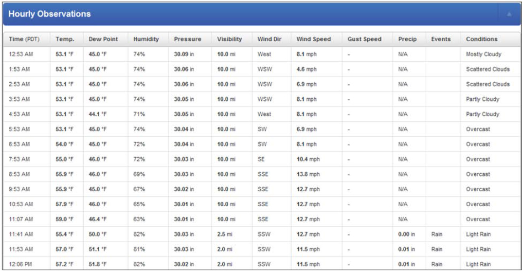
NOAA monitors weather across the United States. NOAA’s Meteorological Aviation Reports (METARs) provide hourly weather data, including relevant data fields such as temperature, visibility, wind speed, and precipitation. Weather Underground’s historical hourly weather reports can be retrieved via https://www.wunderground.com/. These reports rely on METARs data, and archive metrics for almost every town and city in the United States. Figure B12 shows a sample of hourly weather reports from Weather Underground. NOAA is also providing information on PAST weather based on Zip codes, which can be accessed via https://www.climate.gov/maps-data/dataset/past-weather-zip-code-data-table.
Another weather data source, assembled for use with the Urban Streets methodology (Highway Capacity Manual 2010) provides weather estimated for 284 urban areas. The Urban Streets spreadsheet provides simulated hourly weather generated through a Monte Carlo simulation based on monthly weather statistics collected from the National Climatic Data Center.
Applications in NCHRP 08-139
BrTS data provides crucial information on when, where and why a bridge is hit by a motor vehicle. Analyzing BrTS can help identify crash contributing factors and develop appropriate preventive strategies and countermeasures. A motor vehicle crash report form, if in compliance with the MMUCC by NHTSA, should contain key information, including a bridge/structure identification number which can be linked to bridge inventory. The link between crash data and the bridge inventory database means other relevant information (i.e., AADT, vertical clearance under, etc.) can be integrated into the bridge hit database so that the effects of different factors on bridge hits can be studied in detail.
BrTS data can be used to calculate a segment-level crash rate and flag roadway segments that exceed the upper control limit. The crash rate is simply the number of crashes on a given segment over the last several years (or over the entire time the segment has been open to traffic, whichever is lowest) divided by the vehicle miles traveled over the same period. The upper control limit is a value derived by calculating the mean crash rate for all roads of the same characteristics and estimating one standard deviation above that mean.
BrTS data can be used in an economic analysis of BrTSs by motor vehicles to support a Needs Analysis effort. The cost should include bridge repair cost and road user costs such as traffic delay, detour, and vehicle operating costs. In addition, by knowing how a structure was contacted, collision risk models can be developed for: 1) under-bridge collision with superstructure, 2) under-bridge collision with substructure, 3) on-bridge collision, and 4) tunnel collision. Developing separate models better aligns appropriate risk factors with corresponding collision type and facilitates the development of effective safety countermeasures.
Bridge or tunnel datasets (e.g., NBI, NTI, state DOTs’ structural information system) can be linked to other relevant data sets using the structure number (Bridge Number) or coordinates. For example, NBI can be linked to crash data to obtain crash information from bridge collisions. The NBI dataset can provide detailed information on dimension and clearance (vertical and horizontal), which is critical in preventing bridge collisions. The NBI dataset also provides information on deck protection, pier abutment protection, and the condition of each structure. It can also help to estimate the consequences of the bridge collision. Similarly, the NTI dataset can be linked to other relevant datasets using items within the “Identification Items” category (e.g., tunnel number, LRS ID, mile point, tunnel portal latitude and longitude). For example, NTI can be linked to crash data to obtain crash information on tunnel collisions. The NTI dataset can provide detailed information on the portal shape and minimum vertical clearance over tunnel roadway, which are imperative in preventing tunnel collisions.
Compared to national level bridge/tunnel inventory, state-maintained data such as that from WisDOT and INDOT presented in this section, might supply more accurate and up-to-date information for BrTS analysis and modeling, as well as provide an ease of coordination with other local transportation systems and crash databases.
A successful data analysis depends on the ability to link the primary roadway inventory file (i.e., MIRE), crash file, weather and other safety databases. While such linkage is not automatically present, it can be accomplished in two ways: first, the location of the bridge (e.g., route/milepost, spatial coordinates) can be entered on the state’s bridge files using the same location referencing system as the basic inventory files; second, linked elements in these two files (e.g., bridge/structure identification number) can be entered in the agency’s primary inventory database or in a supplemental file used only for linkage purposes. Indeed, the MIRE roadway segment file includes the bridge number as a key attribute. Linking the NBI data to the MIRE segment file might be accomplished with a supplemental file which includes the current location for each bridge number (Lefler et al. 2017). It is possible to link weather data based on the crash location/area and time to the crash data to examine the impact of specific weathers to BrTS. Additionally, linking vehicle violations, investigation results, and crash reports can be instrumental in understanding unsafe driving behavior as well as driver mistakes, lapses and errors that contribute to BrTS.


