Meeting Future U.S. Mineral Resource Needs: The Role of the U.S. Geological Survey Mineral Resources Program (2025)
Chapter: 4 Science Programs
4
Science Programs
MINERAL INFORMATION AND SUPPLY CHAIN ANALYSIS
Overview
Since 1882, the federal government has collected, disseminated, and analyzed information on the production and use of minerals and materials: by the U.S. Geological Survey (USGS) from 1882 to 1924, the U.S. Bureau of Mines from 1925 to 1995, and the USGS from 1996 to the present. The National Minerals Information Center (NMIC) carries on this tradition, providing statistics, information, and analysis on domestic and global production, use, and flows of minerals and materials important for the U.S. economy, national security, and protection of the environment. As part of this work, NMIC develops and maintains the nation’s list of critical minerals and participates in developing a whole-of-government strategy to facilitate sustainable and secure mineral supplies.
NMIC provides indispensable decision support on mineral resources and materials to the rest of the federal government, and since 2002 has increased its activities in this area. This increase reflects, in large part, greater demand for minerals information and analysis during a period of increased public attention to the availability of mineral resources and the role that domestic and foreign minerals can play in satisfying mineral demand. NMIC advises multiple agencies, including the Departments of Commerce, Defense, Energy, Interior, and State, as well as the U.S. International Development Finance Corporation and the U.S. Trade Representative. In addition, state agencies, mining and manufacturing companies, market analysts, and others rely on NMIC data. Internationally, companies, governments, and organizations often start with NMIC data when analyzing specific mineral industries, making it a foundational and valuable source of mineral economics information around the globe.
NMIC activities fall broadly into two categories: (1) data and information, and (2) analysis.
Data and Information
NMIC and its predecessors have compiled and published annual data on minerals and metals production, consumption, international trade, and related areas for more than 100 years. This long-term dataset, unique to NMIC, enables time-series analysis to track evolving supply chain trends, especially for materials critical to advanced technologies and national security (Fortier et al., 2018).
Each year, NMIC administers voluntary surveys sent by mail (to which more than 35,000 entities respond) as the basis for state-by-state and national estimates of mineral production. It estimates the domestic use of minerals in 235 manufacturing sectors. Internationally, it tracks more than 100 mineral commodities in 180 countries (Malakoff et al., 2025).
Although NMIC puts significant effort into these surveys, including anonymizing the collected data to help encourage participation from the private sector, companies are not obligated to respond to the surveys and may be reluctant to share information, resulting in a response rate of approximately 50%. To address some of the resulting data gaps, public domain information on minerals production, use, and trade might be collected from industry disclosures. Additionally, efforts to utilize artificial intelligence (AI) and machine learning (ML) tools could help to automate and increase the rate at which public documents can be scanned and processed.
NMIC could also move to mandatory reporting if it became a principal statistical unit of the federal government, a designation the Department of the Interior and the USGS have requested for NMIC from the Office of Management and Budget. This change, suggested in NRC (2008), could improve the autonomy, resources, and authority for NMIC to enforce data collection. This type of change could include a requirement for timely reporting, as is done in other countries, and involve adding a stakeholder advisory board and a larger workforce to process the increased intake of data.
Based on the data NMIC collects, it generates more than 675 statistical publications annually, all freely available online to the public. The annual Mineral Commodity Summaries is one of the earliest comprehensive releases of key statistics on minerals production and use anywhere in the world, normally published by January 31 each year (USGS, 2025). This authoritative report provides detailed data sheets for more than 90 individual minerals and materials, offering insights into domestic industry structure, federal programs, tariff regulations, and key 5-year statistical trends. The published data are widely used by the U.S. government, academia, industry, and international agencies and have profoundly influenced their decision making (Fortier et al., 2018; Baskaran and Wood, 2025; Rowan, 2025).
NMIC also publishes the Minerals Yearbook with more detail on each commodity than is available in the Mineral Commodity Summaries. The Minerals Yearbook consists of three volumes each year: by commodity worldwide, by country, and by U.S. state. As of March 2025, the latest Minerals Yearbook chapters were for 2020 and 2021, several
years out of date. NMIC might consider what would be necessary to publish the Minerals Yearbooks on a more timely basis or whether the data could be made available more quickly in alternate formats.
Analysis
Closely related to NMIC’s data and information collection function is its analysis of the data. NMIC conducts analyses of mineral supply chains and advises other federal agencies. For example, NMIC has provided subject-matter experts to advise the Department of Defense on its National Defense Stockpile and its Defense Production Act Title III programs, the U.S. Department of Energy’s (DOE’s) Loan Programs Office, and the U.S. intelligence community. NMIC data and analyses also support the National Science and Technology Council’s Subcommittee on Critical Minerals.
Since the last National Academies review of the USGS Mineral Resources Program (MRP) (NRC, 2003) and the minerals information function (NRC, 2008), NMIC has broadened the scope of its analysis to include the entire material supply chain, including material reuse and recycling; become more forward-looking in its perspectives; and incorporated more economics into its analyses. The Energy Act of 2020 provided further impetus to this broadening of scope by directing the USGS to expand its supply chain and scenario analyses. Current efforts include developing scenarios of supply chain disruptions and assessing their potential effects on the U.S. economy and developing supply and demand scenarios that include possible effects of technology development (e.g., process innovations and new materials) and changes to public policy. Other examples of published work include estimates of price elasticity of demand for mineral commodities used in lithium-ion batteries (Shojaeddini et al., 2024), estimates of embedded flows of niobium in internationally traded intermediate and final products (McCaffrey et al., 2023), and world outlooks for several commodities through 2029 (Alonso et al., 2025).
Moreover, the Energy Act of 2020 gives the USGS the responsibility to develop and maintain the whole-of-government list of critical minerals, which is updated every 3 years. The most recent list and underlying analysis were published in 2022.1 Nassar and Fortier (2021) describe the methodology for determining which minerals are designated as critical. Prior to receiving this responsibility through legislation, the USGS provided input and developed a draft list of critical minerals in 2018 (Fortier et al., 2018). Note that this list of critical minerals overlaps with but is different from the list of critical materials for energy identified by DOE (2023) and the list of strategic materials identified by the Defense Logistics Agency due to differences in material scope. The USGS list focuses on minerals from the perspective of the U.S. economy overall, whereas the DOE analysis focuses on materials in selected energy technologies and the DLA list focuses on materials essential for national security during a national emergency.
___________________
1See https://www.federalregister.gov/documents/2022/02/24/2022-04027/2022-final-list-of-critical-minerals, accessed April 3, 2025.
Challenges and Opportunities—NMIC
NMIC data, information, and analysis and the minerals research and supporting geoscientific information functions of the rest of MRP are useful and of interest to different types of audiences, including mineral economists, policy makers, researchers, and industry professionals. Opportunities for NMIC and other MRP focus areas to enhance the impact of their work exist especially in the potential to leverage the interdependence of science and data reporting. That type of shared approach will be particularly important, for example, where previously mined materials become additional potential resources. Incorporating the characterization research conducted by MRP science in these areas is necessary for NMIC to conduct a quantitative valuation.
A specific example that enhances the value of the data and analyses collected and developed by NMIC and the rest of MRP involves the potential economic viability of resources. NMIC could expand its future-looking capacity by producing estimates of realistically achievable quantities of domestic critical mineral production and establishing targets for domestic critical minerals production that might be realized in coming years (see Recommendation 2). Producing such estimates would mirror a goal set forth in the European Union’s (EU’s) Critical Raw Materials Act, which sets goals for EU domestic capacities, including developing sources to meet 10% of the EU’s annual consumption by 2030 (European Union, 2024). This effort would also be similar to roadmaps some Australian states have for reaching targets in a set time frame (Queensland Government, 2023; Government of Western Australia, 2024). This effort would build upon the defunct Minerals Availability System effort of the former Bureau of Mines, the mission of which was “to provide current appraisals of the engineering and economic availability of non-fuel minerals for consideration in the formulation of both domestic and foreign minerals policy” (Bureau of Mines Mineral Supply, 1973). Alongside geologic information, production estimates could involve the length of time needed to begin new operations. They could also consider (1) resources recoverable with modern technology, (2) resources requiring enhanced extraction technology, and (3) mineral occurrences not recoverable today but possible in the future. A further benefit of this effort could be identification of commodities for which reliable estimates cannot be made, thus setting priorities for future research.
Overall, NMIC might continue to devote relatively more of its attention to the entire material supply chain, to forward-looking assessment, and—especially—to incorporating economic considerations into its analysis (see Recommendation 1). Additionally, NMIC would provide a valuable service to data users if it were more transparent about how it benchmarks its data against data from other providers, including other geological surveys, especially data from countries outside the United States and the NMIC system of voluntary surveys.
By addressing these gaps and challenges, MRP–NMIC activities will be able to develop increasingly more reliable, granular, and economically realistic future scenarios of supply and demand of mineral resources. Industry and decision makers currently rely heavily on these data in forecasting globally, and several small changes could make the data and analyses provided by the USGS even more valuable.
Conclusion 4-1: The National Minerals Information Center (NMIC) provides a unique and indispensable service to the nation and the world with its minerals data, information, and analysis. Continuing to refine and enhance the data and information it collects and disseminates and the analysis it undertakes in collaboration with Mineral Resources Program research and assessments will further enshrine NMIC’s critical role in the government’s mineral ecosystem and lead future resource evaluations (see Recommendations 1, 2, 3, and 7).
MINERAL RESOURCE RESEARCH AND ASSESSMENTS
Overview
An important mission of MRP is to conduct research and assessments of mineral resources in order “to evaluate known mineral deposits and estimate undiscovered mineral resources.”2 Undiscovered mineral resources are regions of prospectivity identified through rigorous sampling, testing, geophysical and geochemical analysis, and modeling that can lead to discovery of economically viable resources. MRP scientists examine the full life cycle and supply chains of mineral resources from formation and occurrence through extraction, use, disposal, and recycling.3 They evaluate both current and potential economically extractable mineral resources, as well as those that are yet to be discovered (Rowan, 2025), often within a mineral systems framework (see Figure 4-1). The mineral systems concept (e.g., Hofstra and Kreiner, 2020, and references therein) is based on the premise that the capability to spatially predict the location of major new mineral deposits depends on an understanding of the physical and chemical requirements necessary for their formation. The motivation for developing the mineral systems approach is that, as most if not all near-surface deposits have been discovered, exploration needs to become more predictive and focused on areas that are concealed or traditionally underexplored.
MRP has a reputation for excellence in the area of mineral assessments and research. It performs work related to national mineral resource priorities that would not be conducted otherwise. MRP occupies a unique position in the mineral research space because its research projects can provide long-term, increasingly deep understanding of mineral resources. For example, its research program on the Creede, Colorado, silver, lead, zinc, copper, and gold deposits, which began a century ago, has incorporated emerging technology and newly acquired data into a mineral systems framework to develop an increasingly detailed understanding of this important ore deposit (see Box 4-1).
It should be noted that for MRP, the terms “mineral resource” and “mineral resource assessment” are applied more broadly than common definitions. A mineral resource is typically defined as a “concentration or occurrence of solid material of economic interest in or on the earth’s crust in such form, grade, or quality and quantity that there
___________________
2See https://www.usgs.gov/science/science-explorer/minerals/Assessments-of-Mineral-Resources accessed April 3, 2025.
3See https://www.usgs.gov/programs/mineral-resources-program/about accessed April 3, 2025.
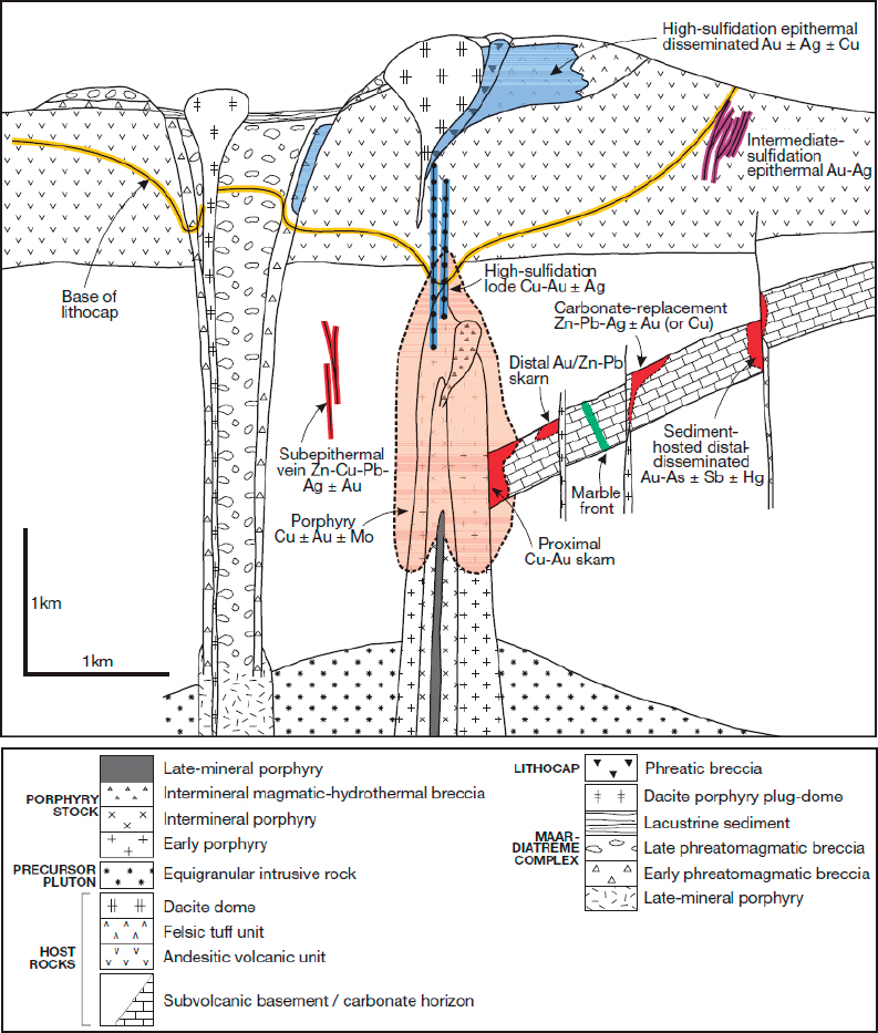
NOTE: This mineral system includes several different deposit types that are genetically related; form in a subduction environment; and are associated with shallow, intermediate composition plutons and magmatic hydrothermal activity. These deposit types include porphyry, greisen, base-precious metal veins, skarns, and epithermal precious metal deposits. Hofstra and Kreiner (2020) presented a modified version of this figure that included potential critical mineral occurrences within the system.
SOURCE: Sillitoe, 2010.
BOX 4-1
The Unique Position of the USGS to Undertake Long-Term Research on Mineral Systems
Understanding the physical and chemical processes behind ore formation requires many years of dedicated research. USGS MRP is uniquely positioned for long-term, spatially extensive, research on mineral systems, exemplified by its thorough study of the Creede mining district in Colorado. Over a century, the USGS has advanced knowledge of its geology, structure, hydrology, and ore genesis, enabling production of nearly 24,000 metric tons of silver, along with lead, zinc, copper, and gold (Barton et al., 2000).
The century-long “Creede project” trained multiple generations of economic geologists and produced classic publications on ore formation. Early USGS studies (Emmons and Larsen, 1923; Larsen, 1930) documented the area’s silver, gold, lead, and zinc resources. Mid-20th-century research focused on the geology, age, and structural controls on ore deposition (Steven and Ratte, 1965; Steven et al., 1967), while later studies provided detailed geologic maps (Steven and Ratte, 1973; Lipman, 1974, 1975, 1976) and insights into geochemical, hydrothermal, and mineralization processes (Steven and Eaton, 1975; Bethke and Rye, 1979; Woods et al., 1982). The most recent geochemical studies would have been far less valuable in terms of understanding the evolution of the ore-forming system had the earlier geology and mapping-focused work not been available. An extensive bibliography of several hundred publications (Hayba and Conte, 1987) shows the breadth of this vast research initiative.
In the 1990s, the U.S. Continental Scientific Drilling Program drilled two core holes to study the hydrothermal system responsible for ore deposition (Bethke and Hay, 2000; Bethke et al., 2001). This effort, supported by the USGS, National Science Foundation, and DOE, was the first to drill through a complete ore-forming system and was successful because of the large amount of previously collected data to guide the drilling. More recently, research shifted to the environmental impact of mining, using Creede as a natural laboratory to study water contamination and inform remediation efforts (Kimball et al., 2006), and geological studies of the caldera continue (Lipman, 2024).
When most of this research was being conducted, there was little interest in critical minerals. However, the mineral sphalerite can contain significant concentrations of critical minerals such as cadmium, germanium, gallium, and indium, and today is the main ore mineral for cadmium. The long-term and detailed research conducted on sphalerite from the Creede District contributes to the nation’s effort to produce these critical minerals, even though the original research was not focused on these materials.
are reasonable prospects for eventual economic extraction” (CIM Standing Committee on Reserve Definitions, 2014). However, MRP study areas may include mineral occurrences that are not currently of economic viability, and thus are not strictly mineral resources by this definition, in order to prepare the nation for possible future demand. As an example, in the early 1900s the lowest grade of copper that could be mined economically was about 4%, whereas in 2010, the average economic copper grade was about 0.6% (Mudd et al., 2013), meaning that deposits that were once not of economic interest now are. Moreover, as technology advances, material that was previously considered to be waste now has potential economic value.
Similarly, the term mineral resource assessments can be defined differently in different contexts. For land-use decision makers, a mineral resource assessment is a report that gathers and analyzes information to determine mineral potential in a particular area at a specified level of detail (e.g., BLM, 1985). This type of mineral resource assessment may be contracted with state agencies, universities, private consultants, and federal agencies, including the USGS. However, MRP includes in its mineral resource assessment studies that are not limited to informing a particular area of interest, such as developing national databases and national maps delineating potential mineral resources.
Both mineral resource assessment and mineral resource research activities are described in more detail below.
Mineral Resource Assessments
According to the 2022 USGS Energy and Mineral Resources Mission Area (EMMA) report (Ryker, 2022), MRP resource assessments and inventories are used for evaluating the potential for known, potential, and undiscovered domestic and global deposits of minerals. Many MRP mineral resource assessments inform land-use planning and management and aid policy makers in understanding global resource issues. For example, the Sagebrush Mineral Resource Assessment provided the Bureau of Land Management (BLM) information on mineral resources in sage-grouse habitat areas considered for mineral closing orders (Frank et al., 2016; see Box 7-1). MRP’s global copper assessment has been used by geological surveys and the private sector around the world, and a tungsten assessment for eastern California and Nevada is guiding BLM land-use plans in the Great Basin region of the United States (Ryker, 2022). MRP is also currently working on nationwide lithium and graphite assessments (i.e., critical minerals needed for batteries for electric vehicles) as well as a program to incorporate AI to improve the speed and accuracy of mineral resource assessments.
MRP’s geological evaluation and assessment of mineral resources uses a mineral systems approach (Wyborn et al., 1994; McCuaig and Hronsky, 2014; Hofstra and Kreiner, 2020). As noted above, a “mineral system” encompasses a group of mineral deposits that are genetically related and form within the same geological and tectonic environment. Thus, developing an understanding of a given mineral system provides a basis for understanding the origin of a particular group of genetically related deposits hosting a variety of critical minerals, with all the members of this group having been formed in the same geologic and tectonic setting but associated with perhaps different
physical and chemical processes. As an example, the porphyry copper-molybdenum-gold mineral system (see Figure 4-1) includes porphyry copper deposits, porphyry copper-gold deposits, porphyry copper-molybdenum deposits, lead-zinc-copper-iron skarn deposits, epithermal gold-silver-mercury-antimony deposits, and others. Additionally, within a given deposit type, several different critical minerals may be produced as byproducts during mining and processing of ores to extract the primary metal. For example, porphyry copper deposits produce copper as the main ore metal but also produce various amounts of other metals as byproducts, including gold, silver, zinc, lead, selenium, tellurium, arsenic, molybdenum, rhenium, and others (see also Figure 4-10). About 80% of all rhenium, selenium, and tellurium production comes from mining porphyry copper deposits (John and Taylor, 2016). Full characterization of all materials in these mineral systems is essential to identifying the potential for co-production of minor but critical constituents.
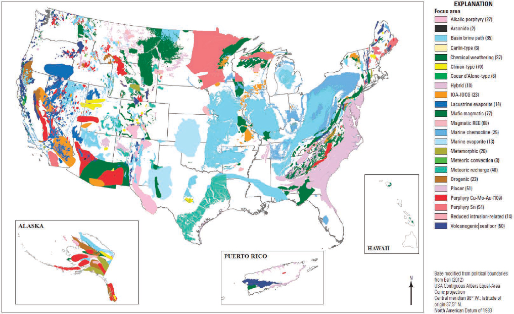
A national map of focus areas for potential critical mineral resources in the United States (see Figure 4-2) provides a framework for more focused mineral assessments. This map focuses on mineral systems’ potential domains. Twenty-three mineral systems are mapped, and 800 areas are identified for focused assessments (Rowan, 2025). Surface mapping, combined with analytical work conducted in MRP laboratories, is ongoing to increase the resolution of and confidence in the mineral resource potential estimates of these systems. For example, the large Marcellus shale district in the eastern United States (labeled as “marine chemocline” in Figure 4-2) contains significant known gas reservoirs but also contains anomalous lithium (Mackey et al., 2024). Coal deposits in West Virginia and Kentucky that are interlayered with clays (identified as the “chemical weathering” focus area in Figure 4-2) could also be a potential source for rare earth elements.
The mineral assessments effort has already yielded new discoveries of potential resources. An example of a recent resource discovery in mine waste is the gallium-niobium discovery in the Arkansas bauxite region, that was identified in above-surface low-grade materials that were related to previous aluminum mining activities (Van Gosen and Choate, 2021). Such discoveries have yet to be quantified in terms of actual resource economic viability, particularly those for which extraction and processing methods need to be defined. Nevertheless, with regard to the mission of MRP, the identification of new potential resources in the United States is important and leads to follow-up work to understand the mineral systems, geometallurgy, and extractability.
Mineral Resource Research
Mineral resource assessments are supported by mineral resource research. MRP conducts a wide variety of research activities, including geological framework studies, geochemistry and geophysics research, studies on the environmental impact and potential for reprocessing of aboveground waste resources from legacy mining, and the development of analytical tools and databases to support mineral resource research and assessments. This research encompasses a wide range of projects from basic to applied and local to global. Based on information provided to the committee, research
SOURCE: Hammarstrom et al., 2023.
projects funded in fiscal year (FY) 2024 illustrate this breadth and include the following: understanding platinum group elements, chromium, nickel, and copper prospectivity in ophiolitic rocks in Alaska; spectroscopic determination of critical elements in sphalerite (see Box 4-1); porphyry copper systems of the Boulder Batholith, Montana; regional metallogeny and framework geology of the Kuskokwim region, Alaska; geophysical exploration of the Basin and Range; and assessment of lithium in granite-related and lacustrine evaporite–related mineral systems. The process for selecting research projects is discussed in Chapter 5.
MRP is well positioned to understand and provide knowledge on the fundamental characteristics and occurrences of future critical minerals distributions. Fundamental research often has no obvious practical applications when the research is being conducted; they often only come to light years later. An example of this is early high-technology National Aeronautics and Space Administration (NASA) telecommunications research that resulted in everyday uses such as color television (Klesman, 2019). Similarly, fundamental mineral characterization research by USGS scientists over the years demonstrated the association of tellurium, which is now a critical mineral used in high-purity semiconductors, with copper ores and waste streams (Watterson et al., 1977). Today, Kennecott Copper and other companies use such data to produce tellurium from copper ores by understanding tellurium element deportment (Rio Tinto, 2022). Fundamental research conducted by MRP scientists on rare earth elements in the minerals monazite and apatite in the Adirondacks, combined with USGS geophysical surveys, revealed potential for economically viable rare earth deposits (Taylor et al., 2019) that are currently being evaluated by U.S. and Chinese companies.
An example of how results from fundamental research were applied in more practical applications is the development of a method to determine trace amounts of silicon in biological and geologic samples. The method involves sample digestion in hydrofluoric acid followed by analysis using inductively coupled plasma–mass spectrometry. Once the technique was developed for rocks and minerals, it could be applied to measure silicon concentrations in plants and soils and is now used to measure silicon in lung biopsy tissue from military personnel and coal miners who had been exposed to silicon-bearing dusts (Arslan and Lowers, 2024).
Challenges and Opportunities—Research and Assessments
MRP’s mineral resources assessment and research activities are widely recognized externally for the quality of their output. As discussed in subsequent sections and chapters, stakeholders, both nationally and internationally and from public and private sectors, attest in surveys that they value and use MRP research. MRP activities provide crucial data on and assessments of national and global mineral resources, including currently recoverable, potential, and as-yet undiscovered deposits of the mineral resources that support national needs now and in the future. MRP’s mineral resources assessment and research products are authoritative and respected both nationally and internationally. They contribute to the USGS’s well-established reputation for providing accurate and unbiased geoscience information. The committee urges MRP to continue and expand on
its excellent work in this area, with the goal of keeping publicly available information on U.S. mineral resources as current and accurate.
Opportunities for Collaboration
The responses to the questionnaire given to MRP staff (Appendix B) indicated some communication and collaboration opportunities that could be explored and adopted to improve efficiency and collaboration across the USGS and across agencies (see Recommendation 7). For example, mineral systems assessments benefit from the integration of results from the Earth Mapping Resources Initiative (Earth MRI), which provides the base data layers needed for comprehensive understanding of mineral systems. More and better opportunities could be created for staff in these two program areas to exchange information and collaborate.
Increased collaboration between mineral resources research and assessment staff and NMIC staff could link available resource and production data to mineral systems models in order to reduce uncertainty related to mineral capacity and production potential. MRP already has a unique opportunity to link mineral systems data for exploration and resource assessment directly to its geoenvironmental models framework, which was originally based on ore deposit models (Plumlee and Nash, 1995) and could be expanded into mineral systems more broadly. This is an example of a conceptually simple and strategic step MRP could take to connect the datasets it already holds.
More collaboration between MRP and the Energy Resources Program (ERP) could add value and strengthen each of these separate units by working together on some synergistic activities. Geoscientists are multidisciplinary scholars, with many science, technology, engineering, and mathematics skills that apply both to minerals and to energy, as well as to biology, chemistry, and environmental science. ERP researchers have expertise that is complementary to the expertise of MRP researchers, and creating opportunities across MRP and ERP would greatly enhance national mineral resource assessments and contribute to a better understanding of energy resources. Potential also exists for increased efficiency in data gathering and characterization of the subsurface, an activity that is performed by both MRP and ERP staff. As an example, understanding the chemistry of brines in deep aquifers is required for gas production from unconventional hydrocarbon reservoirs, for understanding of storage environments for carbon sequestration, and as a potential source of the critical mineral lithium. Additionally, research in areas such as natural hydrogen and geothermal energy (primarily in the domain of ERP) or seafloor mining (primarily in the domain of the Coastal and Marine Hazards and Resources Program within the USGS Natural Hazards Mission Area) can and do benefit from close interaction with MRP.
Advancements in Data Science
MRP could further exploit developments in data science to update assessment techniques and interpretations. MRP is currently developing AI and ML data processing and analytical tools in collaboration with the Defense Advanced Research Projects
Agency.4 The CriticalMAAS (Critical Mineral Assessments with AI Support) program is an early-stage data initiative that holds promise for extracting geospatial data and generating mineral potential maps. The rock-to-metal-ratio for mine waste program in NMIC (Nassar et al., 2022) generates data with environmental predictivity potential that would benefit from science inputs from mineral resource research projects that provide the geological, geochemical, and mineral information necessary for effective predictive models.
A National Atlas
The committee suggests that, in order to expand upon national characterization efforts, MRP consider constructing an evolving, national atlas of resource potential maps (see Recommendation 3). Such an atlas could be constructed over time by starting with a prioritized list of critical minerals but eventually include all minerals and commodities. The product could be a live digitized database that would allow easy access for the public and government entities to access assessments by MRP over large spatial areas. Covering the entire United States, rather than areas currently deemed to be prospective for the current list of critical minerals, would allow flexibility in the future when more data are collected and national needs change. Creation of such an atlas would expand current resource assessment activities; build on the data generated in other areas within MRP; incorporate mineral systems models, metallurgy and mineral economics; and cover the entire nation. While this would be a large, ambitious, long-term goal for MRP, it would serve as a guide for basic and applied research conducted by MRP and would be invaluable to the nation. Furthermore, this national atlas would serve as an excellent deliverable to private industry partners as they work toward defining new domestic sources of mineral resources.
Conclusion 4-2: The mineral resource research and assessments conducted by the Mineral Resources Program (MRP) provide fundamental information on mineral resources—known, potential, and yet to be discovered. This includes information related to the physical (including geological and tectonic) and chemical (mineral system) environment in which deposits form as well as locations and amounts of various mineral resources that are available. MRP’s investigations provide industry-credible, unbiased, and authoritative data on which exploration and resource development are based. These data must be kept current, expanded, and made available to decision makers, industry, and the public for new applications and utilization in a timely manner (see Recommendations 3 and 4).
___________________
4See https://www.usgs.gov/centers/gggsc/science/21st-century-prospecting-ai-assisted-surveying-critical-mineral-potential#overview, accessed April 3, 2025.
EARTH MAPPING RESOURCES INITIATIVE
Overview
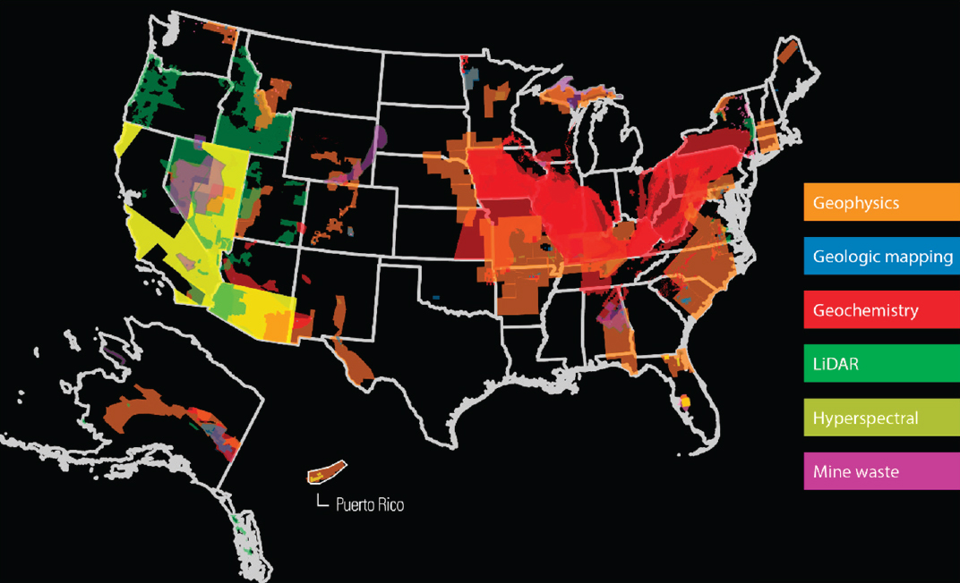
Earth MRI is a core geological and geophysical program of MRP. The overarching goal of the program is to “improve our knowledge of the geologic framework in the U.S. and to identify areas that have the potential to contain undiscovered critical mineral resources” (Day, 2019). Earth MRI, which launched in 2019, represents the most significant effort to characterize the nation’s mineral resources since the National Uranium Resource Evaluation (NURE) program in the 1970s and the Alaska Mineral Resource Assessment Program (AMRAP) in the 1980s (see Box 4-2). In the 6 years since Earth MRI’s inception, 86 mapping and 21 geochemical projects have been carried out (see Figure 4-3) in coordination with 35 state geological surveys.
Earth MRI’s strategy to identify U.S. mineral resources differs significantly from that of previous programs in that it goes beyond describing Earth’s surface to characterize the three-dimensional (3D) volume from which mineral resources could be produced. Historically, mineral potential has been determined by its surface signature, for example, from geological mapping and geochemical characteristics of outcrops or soils. As the mineral deposits identified by these means are developed, the search for additional buried mineral resources requires greater focus on the subsurface. Earth MRI includes both surface and subsurface methods in order to characterize both new and historically important mineral commodities.
Earth MRI began with an annual budget of roughly $10 million in 2019. In 2021, $320 million was added to the program over 5 years, and in 2023 Earth MRI received a small amount of funding specifically for enhancing natural hazard resilience in Puerto Rico. Approximately 75% of Earth MRI funding is sent outside of the USGS to state geological surveys for geologic, geophysical, and geochemical mapping that is focused on locating and defining potentially mineralized systems, and to private industry for the acquisition of datasets to assist that mapping.
Data Collected
The current datasets being acquired through Earth MRI include geologic information and associated geochemistry and 3D geological modeling; airborne hyperspectral imaging surveys using visible, shortwave and thermal infrared wavelengths; airborne electromagnetic surveys; mine waste characterization and inventories; lidar surveys; and airborne magnetic and (aeromag) and radiometric surveys. These datasets are published continuously and will support a wide range of geoscience activities well into the future. The data types collected not only are appropriate and useful for mineral exploration but also benefit myriad other types of investigations as well: identifying sand and gravel deposits (material for the construction of roads and buildings); studying and managing geothermal and water resources; mapping natural hazards; and planning renewable energy, land use, and other infrastructure, specifically energy infrastructure such as
SOURCE: https://www.usgs.gov/special-topics/earth-mri/science/earth-mri-progress, accessed April 7, 2025.
pipelines and buried transmission lines. States participating in Earth MRI will therefore often propose data collection in areas that are high priority for mineral exploration as well as being useful for other synergistic activities. A similar practice is followed by other organizations. For example, the British Geological Survey is using its Tellus geophysical survey to document natural resources as well as the state of the environment (Young, 2016). Similarly, the ancillary Earth MRI datasets collected using gravity, airborne electromagnetics, and magnetotelluric methods can also provide valuable baseline information for a wide range of geological projects. These data are collected if deemed appropriate by USGS researchers and if funding is available.
Datasets collected by Earth MRI provide substantial improvements over previous efforts. Current high-resolution data typically involve flight lines 300 m apart, which is a 10-fold improvement in resolution over that of the NURE program, in which airborne magnetic-radiometric data were collected using flight lines spaced 3 to 6 miles apart (see Figures 4-5 and 4-6). The higher resolution improves the likelihood that smaller areas for prospectivity that would otherwise be missed with the coarser grid spacing may be identified (see Figure 4-5). Additionally, the geochemical analyses of new samples
BOX 4-2
The NURE Program and AMRAP
The NURE program (Hill et al., 2009) was an effort to locate the nation’s radioisotope resources in the dawn of the nuclear age in the 1970s. The program was initially run out of the Atomic Energy Commission and then transferred to the Research and Development Administration (predecessor to the Department of Energy) in 1974. The program consisted of nine components, including radiometric and aeromagnetic data collection and sample collection and analysis over much of the continental United States. The NURE program also funded extensive hydrogeochemical and stream sediment geochemical analyses across the nation (Smith, 1997), focused largely on uranium but also including other elements. Stream sediments were sampled in order to provide an integrated geochemical composition of the surrounding bedrock. The initial goal was to densely sample the entire lower 48 states and Alaska (see Figure 4-4). Slightly more than 50% of that goal was achieved prior to funding termination in 1983–1984. Despite the program not having fully achieved its sampling goals, the existing NURE geochemical datasets continue to be a valuable resource for a range of research programs, and many samples have been reanalyzed using modern techniques.
AMRAP was a collaboration between the USGS and the Alaska Division of Geological and Geophysical Surveys in the 1980s. The program focused on geological mapping and geochemical analyses and did not include a geophysical component.a
SOURCE: McLemore and Chamberlin, 1986.
a See https://dggs.alaska.gov/pubs/project/466, accessed April 7, 2025.
and reanalysis of existing samples include the full suite of elemental compositions, not only elements that may be of current interest. All geochemical analyses are carried out at the same contract laboratory so as to be directly comparable. These hyperspectral surveys are only flown in areas with exposed surface rock, primarily in the southwest of the continental United States. These data are acquired in coordination with the NASA Geological Earth Mapping Experiment (GEMx) mission.
Surveys are conducted both as broad regional reconnaissance and targeted efforts. Additionally, magnetic-radiometric surveys provide high-resolution data over three times more area of the country than when the program began; at the current rate, national coverage could be complete in ~15–20 years (Figure 4-7) if the funding levels for Earth MRI remain at or exceed those since the program received increases in 2021. These
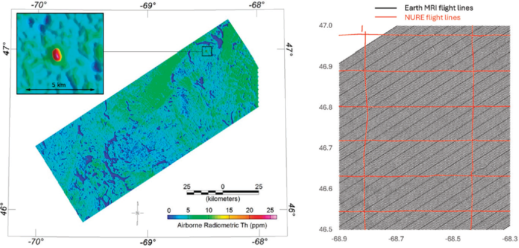
NOTE: The higher resolution of Earth MRI data allows for discovery of prospective areas such as the newly discovered anomaly visible as the red feature in the top left of the figure. Such small features might not be evident in previous generations of data. This NURE dataset was collected in 1980.
SOURCES: https://www.usgs.gov/media/images/pennington-mountain-critical-minerals-earth-mri-geophysical-scan, accessed April 7, 2025 (left); data from Shah (2022) and Hill et al. (2009) (right).
SOURCE: Wyoming State Geological Survey, 2024.
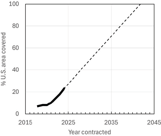
NOTE: The strong uptick results from the Earth MRI supplemental funding increase at that time. The projection line assumes that the average rate from 2022 to 2024 continues.
SOURCE: Data from https://www.usgs.gov/special-topics/earth-mri/science/earth-mri-progress, accessed April 7, 2025.
high-quality datasets will serve the nation’s geoscience community for many years to come and will provide crucially important information for assessing and exploring the nation’s mineral resources. Lidar surveys in particular are nearing completion of national coverage in the framework of the USGS’s 3D Elevation Program (3DEP).
Project Selection and Stakeholder Input
Earth MRI project proposals are developed by state geological surveys in coordination with USGS staff, with the final project selection made by the USGS. The main selection criteria for geologic and geochemical projects include that
- the area has known or suspected mineral endowment,
- the area has potential to host several critical mineral deposit types,
- the area lacks modern geoscience data needed to evaluate the critical mineral potential, and
- the land status will allow mineral exploration and development for the reasonably foreseeable future.
The selection of priority areas for Earth MRI projects is carried out as a collaborative effort between MRP and state geological survey personnel. This process involves annual multiday workshops with broad participation from MRP personnel and up to two representatives from each state survey. Sessions include a summary of past work and extensive discussion of new focus areas.
The questionnaire circulated to state geological surveys by this committee was designed to assess the effectiveness of collaboration, data sharing, focus area identification, and other topics (see Appendix B). With some exceptions, state surveys were generally satisfied with the Earth MRI program and process, particularly the funding levels available to states, the process of identifying focus areas, and the clarity of the USGS’s decision-making process for which projects to fund. As discussed further in Chapter 7, the relationships between MRP and states could be strengthened in some areas. Many state survey responses highlighted the value of the increased funding made available since 2021 and expressed strong interest in maintaining the higher funding levels to allow program goals to be met. Both the USGS and state geological survey staff, in response to the questionnaire, felt that the data collected through Earth MRI, particularly the geophysical data, have broad uses well beyond mineral systems investigations.
Challenges and Opportunities—Earth MRI
A notable strength of Earth MRI is the ability to collect large, high-quality, and multifaceted datasets over a spatially extensive area. However, processing and releasing large datasets, particularly those collected during airborne geophysical surveys, is a time-intensive process. Despite the large amount of data collected, currently no datasets necessary for a national mineral assessment are complete and will not be complete before expiration of the extended funding. The following sections describe some areas where opportunities exist to increase program visibility and effectiveness to help ensure its continued success.
Data Delivery and Use
Since the funding infusion in 2021, MRP has prioritized data collection within Earth MRI over interpretation and release. The amount of data that has already been collected through Earth MRI is remarkable by any measure. However, state survey questionnaire respondents highlighted their desire for faster and better publicized turnaround times from Earth MRI data collection to data release to stakeholders. In some cases, the USGS can take more than a year from when the contractor collected the geophysical data to process and release these data. The causes for release delays are many, and efforts to reduce that time could greatly benefit the program (see Chapter 6 and Recommendation 4 for more information). Precedent exists at the USGS for rapid data delivery—3DEP lidar data serve as a good example of the ability to release a large digital dataset quickly.
Geophysical data are acquired, checked, processed, imaged, and interpreted in many stages. A barrier in any one stage will have cascading effects on the whole process.
Increasing the number of geophysicists focused on data processing, which could include providing funding and training to state geological survey staff, could help streamline and expedite the data delivery process. Developing and testing AI and ML tools could also help speed interpretation and provide a long-term solution. See Chapter 6 (Timely Delivery) and Recommendation 4 for more information and suggestions of how the data delivery process can be improved.
Communication
Effective communication of the myriad results of this program to the broader scientific community, private industry, the public, state legislatures, Congress, and other stakeholder groups is essential to gathering support for continuation of the program. While this is true in all areas of MRP work (Chapter 7, Public Engagement, Publicity, and Outreach), it is especially true of Earth MRI, for which current funding levels are set to expire in 2026. The USGS has initiated efforts to describe the broad value of Earth MRI5 and has begun documenting success stories.6 However, as discussed in other parts of this report, developing high-impact communication strategies, akin to those used by NASA, would help the USGS convey the value of its work, especially Earth MRI. This approach would also allow scientists beyond the mineral resource arena to become aware of the widely useful geophysical data being collected. State geological surveys are valuable partners in communicating Earth MRI successes, particularly through providing numerous examples of how Earth MRI efforts have supported state-level advances in understanding of mineral resources and geological hazards.
Communicating the value of Earth MRI data is essential to building support for the program and conveying its broader relevance to national priorities. One important element is clearly articulating the overarching motivation for the work—how individual data collection and research activities contribute to the broader goals of Earth MRI and MRP (see Chapter 5, Mission and Execution Strategy). Framing the science in the context of a unified vision and national need not only strengthens internal cohesion but also enhances the ability of scientists and staff to serve as effective advocates for the role of Earth science in addressing critical societal challenges.
A further possibility for demonstrating the value of Earth MRI would be to perform return-on-investment or cost-benefit analysis on the funded projects, or the program as a whole, as has been done by the Australian and Canadian geological surveys (e.g., Ernst & Young, 2020; Deloitte, 2023; see also Chapter 7). These studies are complicated and time-consuming but have the potential to illustrate quantitatively the economic and societal value of the research to nonscientists.
___________________
5See https://www.usgs.gov/media/images/earth-mri-first-five-years-accomplishments, accessed April 7, 2025.
6See https://www.usgs.gov/special-topics/earth-mri/science/earth-mri-action, accessed April 7, 2025.
Project Selection Strategy
A target list of 50 critical minerals, a variety of data acquisition methods, and numerous mineral systems models have led to a focus on small, scattered study areas for some Earth MRI data acquisition types. While this approach captures easily accessible opportunities, it may not be the most effective way to achieve a comprehensive national assessment.
From an airborne geophysics perspective, the reliance on localized projects results in incomplete national data coverage, thus weakening national-scale resource potential evaluations. Additionally, justifying future funding can be challenging for projects requiring complex explanations or significant time before their broader impacts are clear. Shifting to a streamlined data acquisition strategy with a focus on nationwide coverage (see Recommendation 3), perhaps similar to systematic data acquisitions like Geoscience Australia’s AusLAMP (Australian Lithospheric Architecture Magnetotelluric Project),7 the USGS 3DEP, and the U.S. Transportable Array,8 could yield more tangible progress and strengthen the case for continued investment. It would also be independent of differences of opinion in potentially prospective areas and the changing landscape of mineral priorities.
The mapping and geochemistry component of Earth MRI could also benefit from a modernized project selection strategy. Although the “full coverage” model suggested for airborne geophysical data collection is not appropriate for geological mapping and geochemical sampling, continuing to integrate the minerals system approach9 favored by the USGS into the project selection process could lead to a more systematic selection of study areas. Furthermore, strategically focusing data collection in order to be able to develop mineral prospectivity maps (Kreiner et al., 2022) for an area would maximize the usefulness of the mapping and geochemical datasets.
Project Selection Process
The original plan for Earth MRI was to “[c]ollaborate with industry, State, and Tribal entities to identify their future science needs” (Day, 2019). Currently, Earth MRI research projects are restricted to collaborations between the USGS and state geological surveys, with supporting geophysical surveys carried out by private industry. No opportunity exists for direct involvement of academic institutions except those that house geological surveys. Greater involvement of academic institutions would have the added benefit of increased student participation in projects over that which is already active at state surveys that include students in their research activities. Opportunities are also limited for other entities such as tribal nations, Alaska Native Corporations, or private industry to be involved in projects except through state surveys. At the time of this report, the USGS has just begun to engage with private industry in project development
___________________
7See https://www.ga.gov.au/about/projects/resources/auslamp, accessed April 7, 2025.
8See https://epic.earthscope.org/content/usarray/transportable-array, accessed April 7, 2025.
9See https://www.usgs.gov/centers/gggsc/science/systems-approach-critical-minerals-inventory-research-and-assessment, accessed April 7, 2025.
(see Chapter 7, Industry), demonstrating an openness to broader input and new collaborations. Encouraging state geological surveys to partner with academia to address more advanced questions regarding mineral systems will add considerable intellectual and analytical capacity and strengthen Earth MRI.
USGS staff involved in Earth MRI generally work closely with state survey geologists to share information and integrate the mapping and geochemical information collected by surveys with the geophysical interpretations done by the USGS. This communication consists of shared field work or data discussion meetings that take place while the research projects are active so as to guide research for both teams. A specific example demonstrating the benefits of this type of collaboration is an instance where geophysical data pointed to the location of a previously unrecognized rare earth element–bearing igneous intrusion in southwestern New Mexico, which was then mapped and sampled by field geologists.
While collaborations with state surveys are essential, more external input into the development and selection of research activities conducted within MRP and Earth MRI would benefit the program on many levels (see Recommendation 5). Gathering and using input from stakeholders demonstrates that MRP is conducting stakeholder-supported research. It ensures that research is more focused on practical needs. It would also align with other agencies’ approaches such as the National Science Foundation’s Directorate for Technology, Innovation, and Partnerships, which focuses on use-inspired and translational research.
More input from private industry, specifically, is encouraged as it could avoid duplicated effort and direct resources to areas more likely to be explored and developed. Efficient targeting via increased private industry collaboration is critical as the United States seeks to remain nimble in response to rapidly changing mineral resource demands (see Chapter 2). Using neutral forums—like the American Exploration & Mining Association conference, the Society of Economic Geologists, or the Prospectors & Developers Association of Canada—to solicit industry input would avoid perceived favoritism while encouraging additional stakeholder engagement. Other mechanisms for external input could include opening the Earth MRI annual planning meeting, which has traditionally involved only state geological survey and MRP staff, to any attendees; hosting Earth MRI open houses at USGS facilities; or others (see Chapter 7 for more details on industry engagement).
Progress Quantification
Because Earth MRI consists of multiple coordinated projects working toward common goals, its progress (and potentially evaluations of staff) could be measured in a more outcome-driven way—not only by papers published or data produced but by also tangible advancements toward the program’s objectives. Easily measurable metrics of progress could include time to data release, the area of Rank 1 geophysical coverage, the area of regions classified as prospective for critical minerals, the number of samples in the sample library that are analyzed for lithogeochemistry, the number of geochemical analyses released to public, the number of data downloads, and the percentage of
the U.S. Mineral Deposit Database (USMIN) remaining to be digitized. Slightly more challenging metrics include the amount of new ground staked and discoveries made as a consequence of Earth MRI. The ideal metrics of success would be those that monitor the objectives defined in the strategic plan developed by the USGS in concert with an external advisory system (see Recommendation 5).
One way to enhance engagement is by gamifying progress. The Earth MRI progress animation10 highlights achievements but does not illustrate what is still required to complete robust critical mineral assessments. For example, Figure 4-8 shows the high-resolution airborne gamma-ray spectrometry map of Australia in 2009 (Minty et al., 2009). The data show detail related to the geological domains as well as coverage gaps. The obvious gaps create an impetus to fill the gaps. Current USGS maps show coverage but not the actual data.
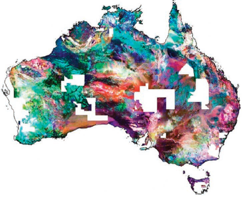
NOTE: Geological and environmental features will be recognizable to many users familiar with local geology. The percentage coverage and locations of missing information are apparent at a glance. Readers will ask, “Why has information for my state not been collected?”
SOURCE: Minty et al., 2009.
___________________
10See https://www.usgs.gov/index.php/special-topics/earth-mri/science/earth-mri-progress, accessed April 7, 2025.
Staffing and Workforce
Earth MRI currently depends heavily on non-domestic contractors for both the acquisition of airborne geophysical data and geochemical analysis. Continued demand for airborne geophysical surveys from the USGS and an expanded U.S. minerals industry could stimulate growth of domestic providers. Diversifying data acquisition sources could help mitigate potential risks associated with changing geopolitical conditions.
Within MRP, staff trained in geophysical data quality control are lacking, with different researchers being used for different project areas. This runs the risk of inconsistent standards being applied or the standards being interpreted differently (see Chapter 5, Staffing, Workforce, and Training for more detail).
Conclusion 4-3: The Earth Mapping Resources Initiative is widely recognized as a huge success from the perspective of the number and geographic breadth of funded and completed projects and amount of data obtained. The continuation and acceleration of this program will provide the foundational data for comprehensive national resource potential assessments as well as support myriad other geological programs, including ones focused on water resources. The information obtained should be made readily available as part of the recommended national atlas of resource potential maps (see Recommendation 3).
MINE WASTE PROGRAM AND UNCONVENTIONAL RESOURCES
Overview
Although not a separate program of MRP, mine waste studies conducted within the broader areas of mineral resource research and assessments and Earth MRI are an important part of the overall MRP science portfolio. Because mine waste studies cut across program areas but were presented to the committee as a thematic unit, they are discussed here as a separate area of MRP science programs. This section covers initiatives in secondary and unconventional mineral resources more broadly.
Mine Waste and the Role of the USGS
Mine waste, a byproduct of mining activities, includes waste rock, processing waste like fly ash or tailings, and mine water. Current U.S. mining activity produces approximately 1.5 trillion pounds of these materials annually,11 and legacy mine features are widespread across the United States (see Figure 4-9). Improperly managed mine waste can lead to severe environmental consequences, such as acid and metalliferous drainage, and has historically contributed to the public’s poor perception of the mining industry (Zielonka et al., 2021; Mencho, 2022). While consideration of the circular economy is
___________________
11See https://www.epa.gov/trinationalanalysis/metal-mining-waste-management-trend, accessed April 7, 2025.
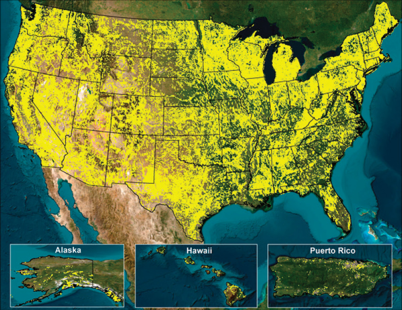
NOTE: The figure shows more than 700,000 current and historical mine and prospect-related features including prospect pits, mines, adits, dumps, tailings, and others.
SOURCE: Horton and San Juan, 2016 (ver. 10.0, May 2023).
critical to the USGS and EMMA (see Chapter 5), environmental stewardship will be increasingly important (IEA, 2021).
In addition to environmental concerns, mine waste has recently gained attention as a potential source of critical minerals. Many critical minerals are not mined directly but are instead recovered as byproducts from primary mineral processing (see Figure 4-10). For example, gallium—a vital component in semiconductors and light-emitting diodes—is exclusively recovered from bauxite and zinc processing (Lu et al., 2017; USGS, 2024). Meanwhile, coal ash in the United States is estimated to contain $8.4 billion worth of rare earth oxides (Reedy et al., 2024). In some cases, mine waste contains primary minerals that were uneconomic to extract at the time of operation. Unmined deposits, active mines, existing processing facilities, and legacy mine sites could potentially meet decades of mineral demand according to a recent USGS report (Vikre et al., 2023). Development of secondary and nontraditional mineral resources like mine waste, coal power byproducts, saline brine from geothermal power plants, produced water from oilfields, and others will likely contribute significantly to meeting U.S. mineral needs (see Recommendations 2 and 3).
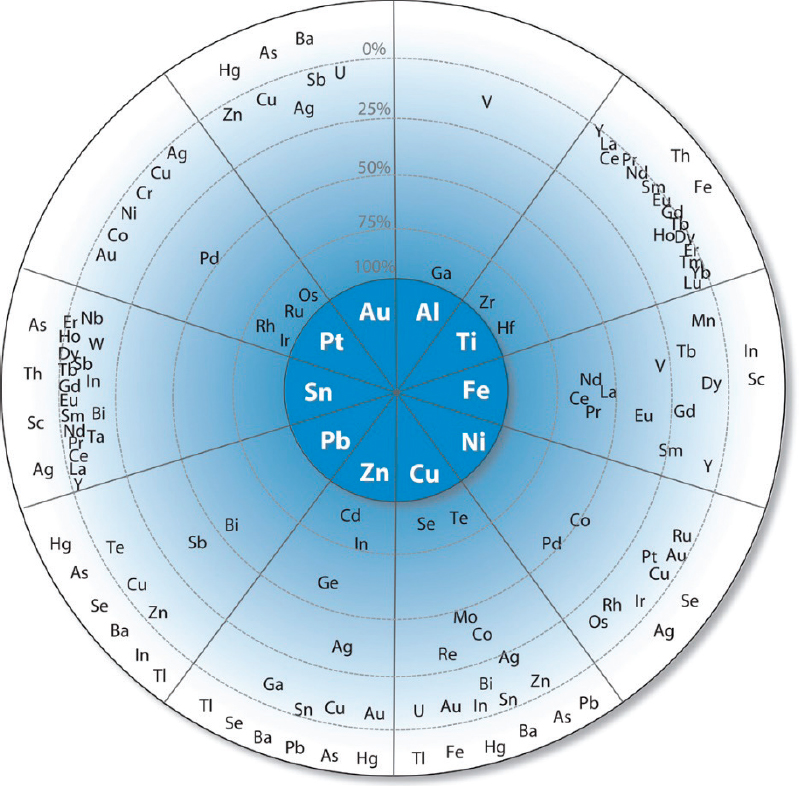
NOTE: The principal host metals form the inner circle. Companion elements appear in the outer circle at distances proportional to the percentage of their primary production (from 100% to 0%) that originates with the host metal indicated. For example, the critical minerals Cd and In plot close to the center next to Zn, indicating that most Cd and In are produced as byproducts in the mining and processing of Zn ores. The companion elements in the white region of the outer circle are elements for which the percentage of their production that originates with the host metal indicated has not been determined.
SOURCE: Nassar et al., 2015.
USGS work on mineral resource sustainability is guided by four goals (USGS, 2024): (1) understanding impacts of mineral development and usage on society, the economy, and the environment; (2) conducting life-cycle studies of minerals to promote efficient use of mineral resources and understanding of their potential impacts during and after use; (3) conducting unbiased research into legacy mine and processing waste sites to identify, prioritize, and facilitate cost-effective reclamation opportunities; and (4) quantifying and characterizing critical minerals in waste products at active and legacy mining sites and processing facilities to promote the recovery of byproduct critical minerals.
The U.S. Government Accountability Office report on critical mineral recovery from nontraditional sources (GAO, 2024) identifies five primary challenges to recovering minerals from nontraditional sources: (1) insufficient characterization of materials; (2) environmental liability concerns; (3) complex permitting processes; (4) economic viability, given low grades and high remediation costs; and (5) social license to operate, including public and tribal engagement. The USGS has a role to play in addressing many of these challenges through research, data, and interagency collaboration.
Current Activities in Mine Waste
Since 2016, MRP has been developing USMIN,12 a comprehensive geodatabase of active and historic mine features in partnership with the BLM. This database is intended to replace the mostly defunct Mineral Resources Data System.13 Although extensive, USMIN remains incomplete and is not yet consistently updated. Additionally, Earth MRI now supports mine waste mapping and sampling to begin to quantify the mineral resource potential in mine waste.
USGS research into mine waste, nontraditional mineral resources, and associated environmental effects spans understanding of major elements and critical minerals in mine waste features, the mineralogy and volume of the resources, and the behavior of mine waste constituents in the environment. Examples include the mineralogical investigation of mine waste to determine the burden of critical minerals and recovery potential from tailings and waste rock; the characterization of coal mine waste and drainage as potential sources of critical minerals; evaluation of oilfield brines for lithium content; assessment of carbon sequestration potential in ultramafic rock; and studies of groundwater flow and metal transport around mine waste features including the behavior of metalloids in surrounding environments. These efforts reflect the effective collaboration across USGS scientists, programs, mission areas, and science centers.
More broadly in the federal government, DOE has been conducting research and development on critical minerals (primarily rare earth elements) from coal waste, ash, and acid mine drainage. Until recently, it had not focused on hard rock mine waste (FECM, 2025). The USGS participates in the interagency Federal Mining Dialogue to coordinate scientific and regulatory efforts related to mine waste and legacy sites
___________________
12See https://www.usgs.gov/centers/gggsc/science/usmin-mineral-deposit-database, accessed April 3, 2025.
13See https://mrdata.usgs.gov/mrds/, accessed April 3, 2025.
(BLM and USFS, 2007; IWG, 2023). Recent “Good Samaritan” legislation, which limits liability for third-party remediation efforts, may open new avenues for the development of legacy sites (Narducci and Reeve, 2024).
Challenges and Opportunities—Mine Waste
The mineral resource potential of mine waste is a nascent area, and in a short period of time the USGS has made significant progress in generating information and developing the science needed to develop mine waste as a critical mineral resource. However, like mineral deposits, mine waste and nontraditional resources more broadly cannot be considered economic resources without quantitative estimates of their mineral endowments and economically viable mining plans and recovery techniques. The committee urges MRP to continue its excellent work in mine waste and suggests expanding its research and assessments within the following areas.
Characterization
Thorough characterization, including mineralogy, geochemistry, and spatial data, is foundational for assessing the potential of mine waste as a resource. These efforts also inform whether post-recovery residues can be reused as construction material or soil amendments, contributing to a circular economy. However, characterization is often expensive, technically complex, and potentially hazardous. Incorporation of geoenvironmental models into mine waste assessments may aid in the prediction of the nature of mine waste and any secondary waste products that may result from the reprocessing of these resources. Additionally, noninvasive geophysical methods (e.g., resistivity, induced polarization, magnetics, seismics, and electromagnetics) offer promising tools to assess tailings structures and subsurface variability and to estimate resource volumes.
Continued coordinated studies to determine which of the many possible waste resources within the United States have the potential for economic recovery will greatly benefit the establishment of national production goals (see Recommendation 2) and potential national resource characterization (see Recommendation 3). A major limitation is the lack of standardized protocols for data collection, integration, and validation. Without these standards, mine waste may require expensive site-specific testing before being treated as a resource. Development of standardized protocols for sampling and statistical methods for estimating the resource endowment of mine waste, such as those being developed elsewhere for tailings storage facilities (Blannin et al., 2022), could greatly benefit this nascent field.
Extractability
Extractability or recoverability is central to assessing the economic potential of mine waste. Although this is true of mineral resources broadly, it is even more crucial to mine waste due to the nonstandard host materials, novel technologies, and special environmental considerations (e.g., Parbhakar-Fox et al., 2013; Blannin et al., 2023).
Geometallurgical prediction of how ore types behave during mine operations and processing could feed into understanding of waste-pile structure, chemistry, evolution, and ultimately extractability. Additionally, fundamental research already conducted by the USGS can contribute to technology adaptation and the development of environmentally friendly technologies for critical mineral extraction from mine waste. For example, the research on microbial communities in and around mine waste could accelerate the development of bioleaching technologies for the recovery of metals from mine waste.
A Holistic Approach to Mine Waste
Hydrological, environmental, and geotechnical assessments that establish the risk associated with mine waste and any post-recovery residues are likely to influence whether a mine waste project will proceed to the development stage. In addition to geochemical characterization, geophysical, hydrological, and environmental background characterization can support safe mine waste development.
Conclusion 4-4: As demand for critical minerals grows, mine waste offers a new opportunity to expand domestic mineral production while addressing legacy environmental issues. The U.S. Geological Survey (USGS) is the only federal entity equipped to lead this research at scale. By building on its strong scientific foundation and integrating mine waste data into national resource assessments (see Recommendations 2 and 3), the USGS can play a pivotal role in unlocking the value of these underutilized resources and advancing sustainable mineral development in the United States.


