The Global Positioning System: A Shared National Asset (1995)
Chapter: The Federal Radionavigation Plan
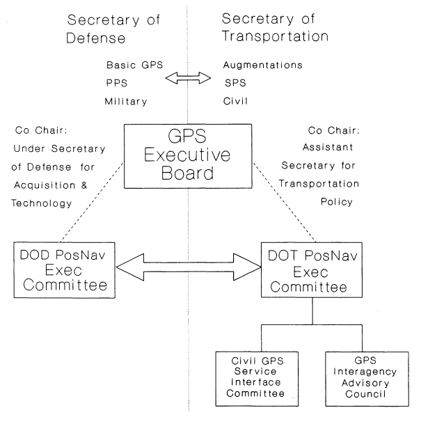
the Secretaries of Defense and Transportation.10 In response to management recommendations made in the report, the DOT has established a DOT Positioning/Navigation Executive Committee to interface directly with the DOD Positioning/Navigation Committee. The duties of the committee chair have been assigned to the Assistant Secretary for Transportation Policy who, along with the Under Secretary of Defense for Acquisition and Technology, will co-chair the newly formed joint DOD/DOT GPS Executive Board. This management structure is illustrated in Figure C-1. The DOT Positioning/Navigation Executive Committee and the Assistant Secretary for Transportation Policy will act as the focal point for GPS plans and policies developed by a number of DOT agencies involved in the use of GPS. These organizations include the U.S. Coast Guard, The Federal Aviation Administration (FAA), the Federal Highway Administration (FHWA), and the Federal Railroad Administration (FRA). The Executive Committee will also receive input from the Civil GPS Service Interface Committee.
The Federal Radionavigation Plan
The Federal Radionavigation Plan is the official source of planning and policy information for each radionavigation service provided by the U.S. government, including GPS. It is jointly developed by the DOD and the DOT, and is updated biennially.11 The Federal Radionavigation Plan represents an attempt to provide users with the optimum mix of federally-provided radionavigation systems, and reflects both the DOD's responsibility for national security, and the DOTs responsibility for public safety and transportation economy. It was first released in 1980 to Congress in response to the International Maritime Satellite Telecommunications (Inmarsat) Act of 1978 (P.L. 95-564).12